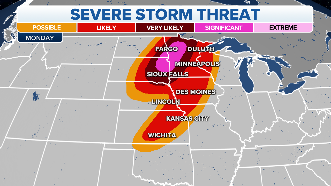
'Particularly dangerous situation' unfolding in Northern Plains, Upper Midwest
'Particularly dangerous situation' unfolding in Northern Plains, Upper Midwest
Download the AppCoverage for this event has ended.

Damage reports
The National Weather Service so far compiled almost 200 reports of storm damage this Memorial Day. Here are a few standouts.
Emergency managers reported that a potential tornado in Starbuck, Minnesota rolled a pick-up truck and trailer. Another potential tornado tore down several farm buildings.
The Appleton Airport in Minnesota clocked a 90 mph wind gust. A wind gust in Dell Rapids, South Dakota blew over a semi. And, 60 mph gusts smashed nickel-size hail into windows.

FlightAware.com Misery Map
The FlightAware Misery Map shows in and outbound flights delayed for the Minneapolis/St. Paul International Airport. So far, 21 flights have been canceled and 189 delayed.

Watches and Warnings
The NWS issued a Severe Thunderstorm Watch for areas of Minnesota and Wisconsin until 2 a.m. (the yellow shading). Cities under threat include Eau Claire and Rochester, Wisconsin.
A Tornado Watch remains in effect for parts of Minnesota until 10 p.m. for cities including Minneapolis, St. Paul and Mankato.

Tornado Watch
The NWS expanded the Tornado Watch that runs through 1 a.m. More Iowa counties are under threat including the cities of Mason City, Clear Lake and DesMoines.

Tornado threat
Over 1.2 million people are under a warning right now. An impressive line of storms is closing in on Minneapolis.
A radar indicated tornado capable of dropping baseball-size hail is over Montrose and moving northeast at 70 mph. Wright County, Minnesota is under a Tornado Warning until 7 p.m.
Itasca, Aitkin and St. Louis Counties are under a tornado warning until 7 p.m.
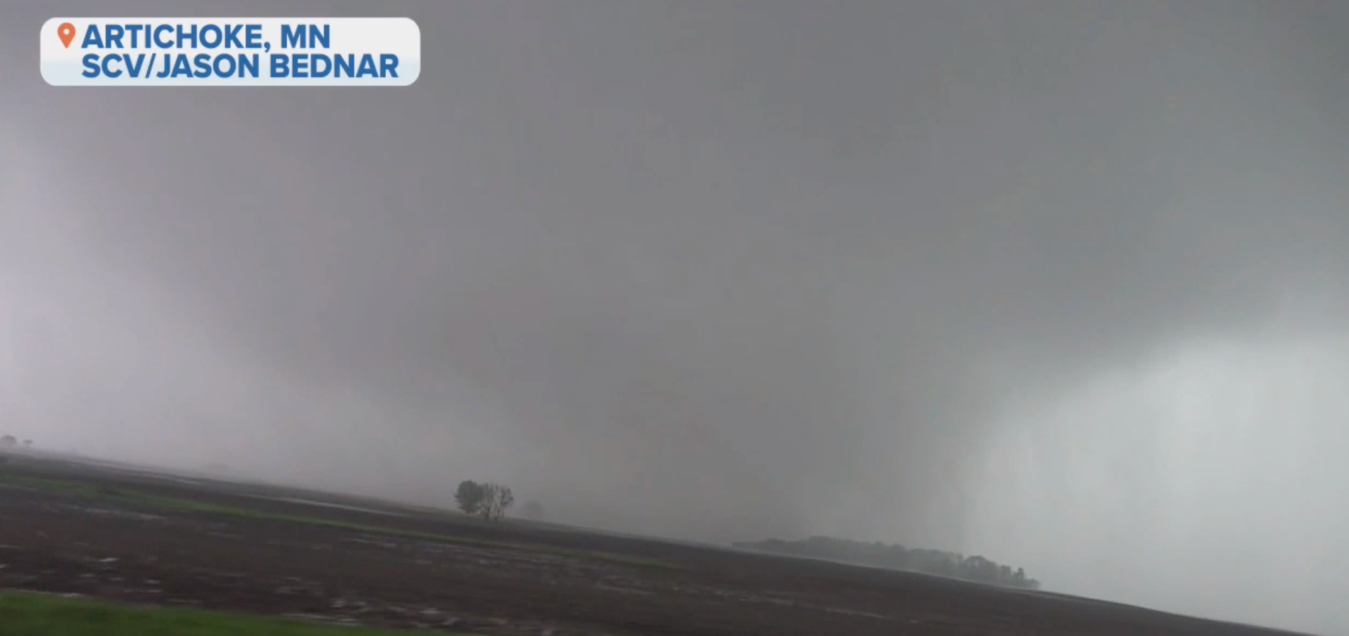
Storm chaser Jason Bednar captures what looks to be a rain-wrapped tornado. From this video, it is easy to see why tornadoes obscured by rain are so dangerous as we can barely see them coming.
According to PowerOutage.US thousands are in the dark.
- Minnesota 28,481
- South Dakota 11,048
- Iowa 5,599
- Wisconsin 4,178
- Nebraska 237
First responders and storm chasers launch drones to get a full idea of the destruction left behind from a confirmed tornado in Forada, Minnesota.

Tornado Watches
The NWS extended the Tornado Watch from Minnesota through Iowa, Missouri and into Kansas. The Minnesota section of the Watch expires at 10 p.m. but the remainder is in effect to 1 a.m.

Tornado Warning
The National Weather Service extended their Tornado Warning for Todd and Morrison Counties in Minnesota until 6 p.m.

Warnings
The NWS identified a tornado by radar near Murdock, Minnesota and moving northeast at 85 mph. Douglass and Todd Counties are under a Tornado Warning until 5:30.
A confirmed tornado near Carlos, Minnesota is moving northeast at 60 mph. That Tornado Warning ends at 5:30 for Todd and Morrison Counties.

FOX Weather Meteorologist Ian Oliver shows an area in Kansas with possible storm development.
FOX Weather is tracking possible storm development near Wichita, Kansas over the next few hours.
If a storm develops, hail, winds and possible tornadoes are possible.
A Tornado Warning is in effect until 4:45 p.m. for south Douglas and west Pope counties in Minnesota.
At 4:17 p.m. the storm line was moving north at 60 mph. If you are in Glenwood, Lowry and Alexandria, take cover now.
The threat continues to move rapidly toward the northeast and is expected to be over Minneapolis around 6 p.m. CDT.

Top wind reports.
As the main line of severe thunderstorms shifts northeast, a top wind gust of 90 mph was recorded at Appleton Airport in Minnesota.
The potentially dangerous situation Tornado Watch continues to bring large hail and wind gusts to eastern Minnesota through Monday evening.
Michael Rios recorded this hail shower video in Sioux Falls, South Dakota as severe storms rolled through the area Monday afternoon.

Severe weather statistics for Monday's storm system.
Top wind reports are rolling in with gusts up to 70 mph reported in Tyndall and Brandon, South Dakota.
Hail reports with golf-ball size hailstones are also coming in from Nebraska and Minnesota.
A tornado was spotted east of Sherman at 3:14 p.m. moving northeast at 35 mph, according to the NWS.
A Tornado Warning was issued for northwest Rock County, Minn. and east central Minnehaha County, SD until 3:45 p.m. CDT.
Those in the area need to take cover now.
Numerous Tornado Warnings are in effect for northeast South Dakota and western Minnesota.
The NWS in Aberdeen, South Dakota has issued a Tornado Warning for parts of Big Stone County in west central Minnesota, and Roberts and Grant counties in northeast South Dakota.
The latest warning continues until 3:45 p.m. CDT.


Hatched hail threat outlook for Monday.
The Memorial Day severe weather threat includes the possibility of large to giant hail.
Reports of large hail have started to come in across South Dakota, Nebraska and Minnesota.
Part of what produces large hailstones is wind. According to the National Weather Service, upward wind speeds of 64 mph will support a hailstone as large as a golf ball, while a grapefruit-sized stone needs a 98-mph updraft.

Tornado Watch for South Dakota and Minnesota until 10 p.m.
Forecasters with the NWS Storm Prediction Center are calling the tornado threat across Minnesota and eastern South Dakota a "particularly dangerous situation" as the severe storm continues to push northeastward.
The latest Tornado Watch from the SPC includes southwest and central Minnesota, including St. Cloud and Grand Rapids. The Watch continues to include northeast South Dakota, including Watertown.
Widespread wind gusts up to 80 mph and tennis-ball size hall are likely. The new Watch continues until 10 p.m. CDT.
Follow live weather alerts in the Northern Plains and Upper Midwest.
The tornado threat is increasing as the storm moves toward the South Dakota-Minnesota state line.
Residents in Dell Rapids, Baltic and Flandreau, Egan and surrounding communities should seek shelter. A Tornado Warning for this area is in effect until 3 p.m. CDT.
Another Tornado Warning is in place for Volga, Arlington and Bruce, South Dakota. That warning continues until 2:45 p.m. CDT.
The tornado threat appears to be increasing across eastern South Dakota, according to forecasters with NOAA's Storm Prediction Center.
A Tornado Warning was issued for Madison, Lake Madison and Ramona, South Dakota until 2:15 p.m. CDT. This includes parts of east McCook county.
The storm was located 7 miles outside of Orland moving north at 55 mph.

Lightning strikes in the last 15 minutes.
More than 3,500 lightning strikes were recorded within the past 15 minutes across the U.S.
The image above shows a concentrated area of lightning in the Northern Plains and Upper Midwest as storms roll through bringing severe weather across four states.
Learn why lightning can rattle your windows here.

Wind Gust forecast for the Northern Plains
Monday's thunderstorms will include potentially damaging wind gusts up to 60 mph or higher in Sioux Falls, South Dakota.
A Wind Advisory remains in effect until 8 p.m. CDT Monday for east central and southeast South Dakota, northeast Nebraska, northwest and west central Iowa and southwest Minnesota, including the Flandreau Santee Sioux Tribal Nation tribal lands.
Intense wind gusts could knock down trees and cause power outages.

Nebraska, South Dakota, Minnesota and Iowa
The first Tornado Watch of Monday's thunderstorm system has been issued by the National Weather Service.
The Watch continues until 6 p.m. for northwest Iowa, southwest Minnesota, northeast Nebraska and southeast South Dakota. About 1 million people are under this watch.
Large hail, damaging winds up to 75 mph and tornadoes are all possible as these storms strengthen.
Potentially dangerous weather is rolling through eastern Nebraska and southwest Iowa throughout Monday and into the night.
The NWS in Omaha is tracking storms off and on throughout the day, with the most severe threat between 10 a.m. and 4 p.m. Some storms could continue past 10 p.m. in far southeast Nebraska and southwest Iowa.
You’ve reached the beginning of this live coverage.