Live updates: Winter storm threatens 200M Americans with potential feet of snow, catastrophic ice
FOX Weather is providing live coverage of a developing winter storm that is forecast to blast 35+ states with dangerous snow and ice through the weekend.
Coverage for this event has ended.
Wednesday's live coverage has ended here, but FOX Weather's comprehensive live coverage of this developing winter storm continues.
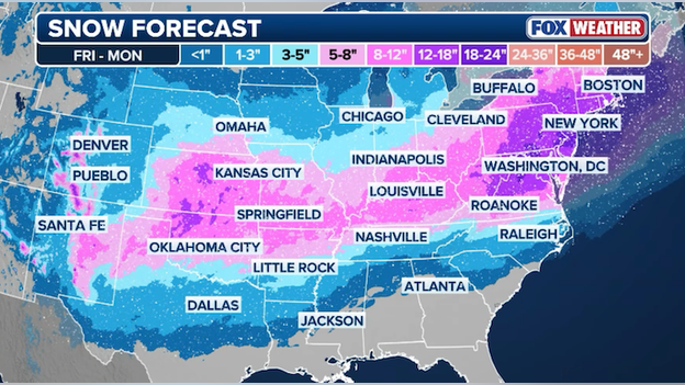
Snow forecast map from the FOX Forecast Center for Friday through Monday.
All eyes are on the snow forecast - and it's a doozy. FOX Weather is calling for more than a foot of snow to fall in portions of the Mid-Atlantic and Northeast, based on current available forecast data. That amount of snow would create a travel nightmare for one of America's most-traveled highways: Interstate 95.
Meteorologists caution that it's still several days out from the first flake flying in the Northeast, so the forecast is likely to change. It's still too early to determine exactly how much snow will fall on Washington, Philadelphia, and New York.
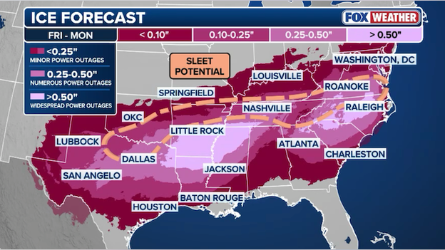
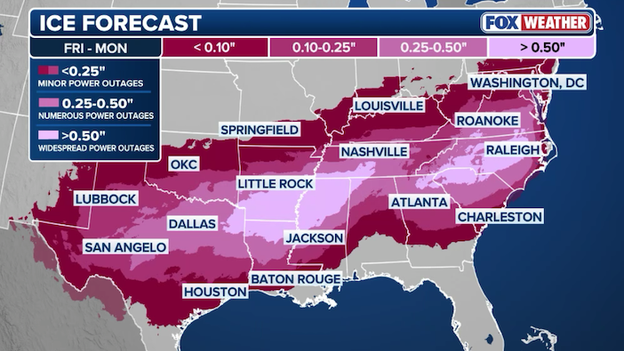
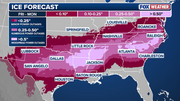
Updated ice accumulation forecast for Friday through Monday from FOX Weather.
The FOX Forecast Center just released a new ice forecast, pinpointing two distinct areas that may see the most freezing rain this weekend. Right now, the focus is on the Ark-La-Tex region, including Memphis, and the Carolinas. These areas have the potential to see catastrophic amounts of ice that could bring down trees and power lines.
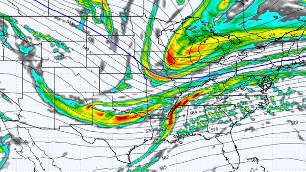
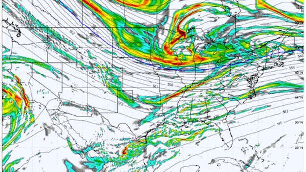
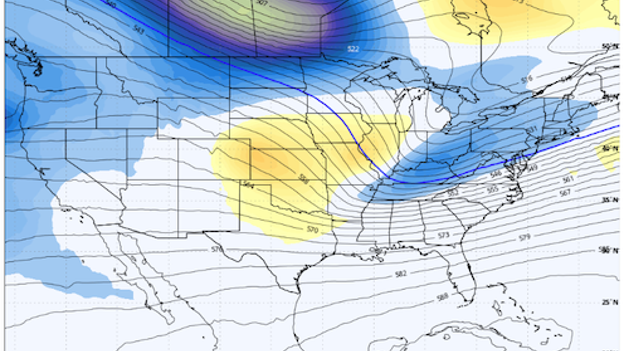
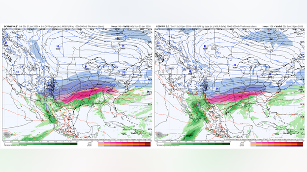
Global Forecast System (GFS) computer model showing upper-level energy on Sunday. (Source: WeatherBELL)
Fresh computer model guidance is coming into the FOX Forecast Center and it reveals just how dynamic this weekend's winter storm will be. Forecasters are now analyzing differences in the new model run compared to earlier runs to identify trends or potential problems in the data. Each new model run shows how the storm may come together, providing meteorologists with better confidence in the forecast. The latest run of the Global Forecast System (GFS) model, known as the 18Z run, shows notable differences in how the storm energy may or may not come together to dump heavy snow in the Northeast.
The FOX Forecast Center is analyzing new computer model guidance that will help drive updated forecasts tonight. Giant supercomputers are ingesting vast amounts of current observation data from around the world right now and are spitting out new forecast models. That data will be used by meteorologists at FOX Weather to provide the most accurate and up-to-date forecast for this weekend's storm.

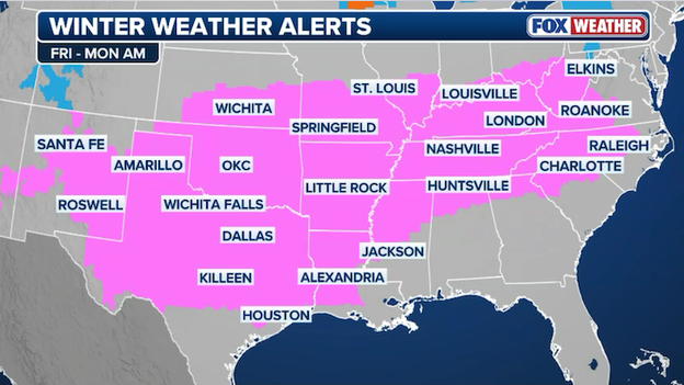
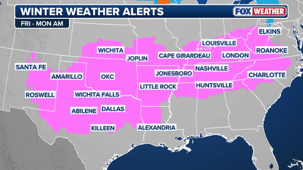
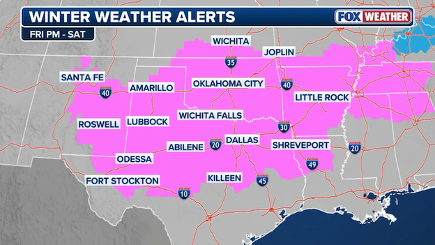
Winter Storm Watches span across the South ahead of the weekend's major storm.
With confidence growing in a colossal winter storm sweeping across America, the National Weather Service continues to issue alerts ahead of the storm. Winter Storm Watches are up for most of the South in anticipation of snow, freezing rain, sleet, and ice. With the storm expected to begin in the Plains on Friday, these watches will be replaced with Winter Storm Warnings in the next 24 hours.
I encourage all North Carolinians to stay home and off the roads this weekend unless absolutely necessary so first responders can do their jobs safely and effectively.
Preparations are underway for winter storm impacts in North Carolina. On Wednesday, Governor Josh Stein declared a State of Emergency to ready state resources ahead of the expected snow and ice.
Preparations are already underway by state agencies, and this State of Emergency ensures Team South Carolina is ready to respond and support communities as conditions develop.
South Carolina's Governor has declared a State of Emergency days before a dangerous winter storm is forecast to hit the region. Governor Henry McMaster is urging people to take precautions now.
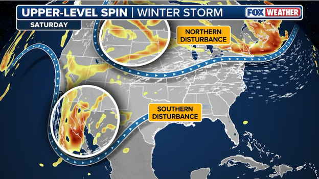
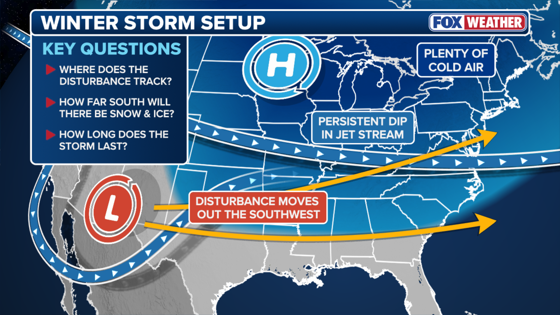
Forecasters are tracking two upper-air disturbances that will merge to fuel this weekend's major winter storm.
FOX Weather meteorologists are working around the clock to determine just how much snow and ice will fall and where across America this weekend. That forecast relies heavily on several ingredients all coming together at the right time and place to spawn a massive winter storm.
You can't see them, but two disturbances high up in the sky will play a key role in the storm's development. A northern disturbance rolling in from Canada and a southern disturbance barreling in from the Pacific will meet up over America's heartland this weekend. As that energy shifts to the East Coast, a new area of low pressure will form near the surface of the earth off the coast. That coastal low will help to drop big snow on the Northeast and I-95 corridor Sunday into Monday.
We're still several days out from snow reaching major cities like New York and Washington, so the exact details remain unclear. Forecasters are working right now to determine exactly where those two disturbances will merge, where the coastal low will form, and how long the low will spin near the coast. New data coming in every few hours helps provide answers to these questions and increase confidence in the overall forecast.
Bottom line: expect to see some changes in the forecast as the storm draws closer, but a significant storm is going to happen.
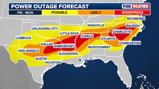
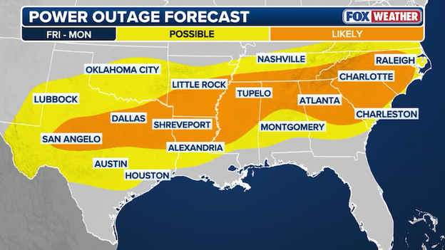
New power outage forecast shows potential for widespread outages in the South.
The FOX Forecast Center just released a new power outage forecast map and it shows just how dangerous this weekend's winter storm will be. Widespread outages are now expected from Texas to Alabama and across portions of Georgia and the Carolinas. Utility crews are already preparing and urging customers in the impacted states to prepare for outages that could last well into next week.
Winter Storm Watches now stretch from the Southwest to Virginia in anticipation of heavy snow and ice.
America's fourth largest city is now under a Winter Storm Watch. The National Weather Service in Houston/Galveston says power outages and tree damage are possible across the Houston metro area from the developing winter storm. Rain is expected to change over to freezing rain as early as Saturday morning. The watch stands as an early "heads up" to prepare for inclement winter weather. FOX Weather expects many of the watches to be replaced with Winter Storm Warnings as the storm gets closer.
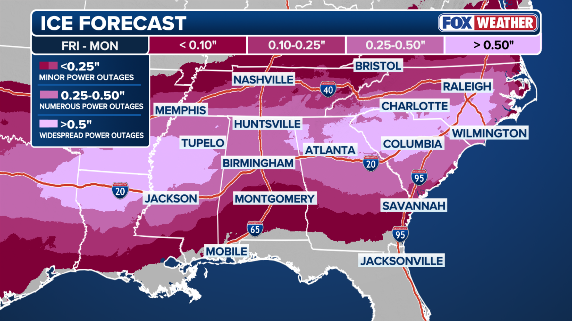
Latest ice forecast from the FOX Forecast Center for Friday-Monday.
It's not all about the snow with this winter storm. Freezing rain and sleet will also be a big problem across multiple states, particularly in the South. Just a few hundredths of an inch of ice can make roads slick, but when that ice adds up, it can become heavy enough to pull down trees and power lines.
FOX Weather's latest ice forecast shows multiple states at risk for more than a half inch of ice accumulating this weekend. This could mean widespread power outages that may last into next week.
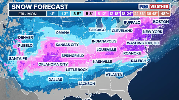
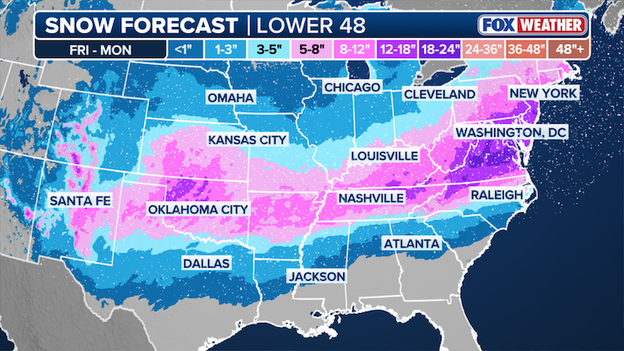
Latest snow forecast from the FOX Forecast Center.
The newest snow forecast from FOX Weather continues the northern trend seen in the overnight computer forecast models. Meteorologists caution that this forecast is not set in stone and subject to additional changes as the storm ingredients come together in the next 48 hours. What is becoming clear is that millions of Americans from the Plains to New England will be seeing significant snow this weekend.
Spirit Airlines has issued a travel waiver ahead of this weekend's big storm. It is waiving change fees for flights in and out of 13 airports.

ECMWF total snow model output through Monday. (Source: WeatherBELL)
The Wednesday morning run of the European Centre for Medium-Range Weather Forecasts (ECMWF) model paints a very snowy picture for millions of Americans this weekend. Widely considered one of the most reliable and accurate computer forecast models available, the ECMWF is used heavily by meteorologists for creating reliable forecasts.
In the past 24 hours, the model has shifted the track of the overall storm farther north. This shift would result in more snow falling from the Central Plains to the Ohio Valley to the Northeast. It also means less snow would fall in parts of the Deep South, which is what you're seeing in the raw model output map shown above.
FOX Weather meteorologists are reviewing this new data now and will be updating the snow forecast this afternoon.
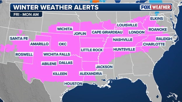
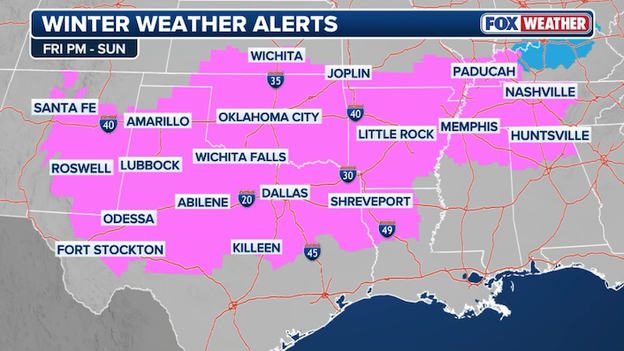
Winter Storm Watches stretch from New Mexico and Texas to Ohio and West Virginia.
The FOX Forecast Center says the developing winter storm will spread across 35+ states and impact an estimated 200,000,000 Americans. As the storm approaches, the National Weather Service is ramping up its alerts to warn people about the snow, ice, and dangerous cold to follow. More than 60 million people are now under some type of winter weather alert - 47 million of which are under a Winter Storm Watch.
Southwest Airlines has issued a travel waiver for 26 airports ahead of this week's massive winter storm. The airline is waiving change fees to and from the affected airports.
Wednesday morning computer forecast guidance from the European Centre for Medium-Range Weather Forecasts model. (Source: WeatherBELL)
The FOX Forecast Center is closely analyzing new data coming in from Wednesday morning's run of the European Centre for Medium-Range Weather Forecasts (ECMWF) model. Considered to be one of the go-to computer forecast models for meteorologists, the data will heavily influence changes to the snow and ice forecast ahead of this weekend's major winter storm.
Stay tuned for updates throughout the afternoon.
Grid conditions are expected to be normal.
ERCOT says it is closely monitoring the cold air forecast to invade Texas this weekend. In an X post on Wednesday, the state's largest electric operator says it will keep Texans informed on grid conditions through various communication channels.
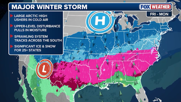
Dangerous snow and ice are expected to blast 30+ states through the weekend.
The FOX Forecast Center is tracking a potentially historic winter storm taking shape later this week. Spanning over 2,000 miles and across more than 35 states, the storm could deliver record-setting snow and dangerous ice from the Southern Plains through the Mid-Atlantic. Forecasters say now is the time to prepare for the storm which is expected to cancel thousands of flights and knock out power in the hardest-hit areas.
Getting a good forecast starts with getting good observations. And that's why the Weather Prediction Center has called upon the Hurricane Hunters for help. An Air Force Reconnaissance C-130J just took off from its base in Biloxi, MS to head toward the developing winter storm. It's goal is to sample the atmosphere in the from top to bottom ahead of the storm so that computer forecast models can get the most clear picture of how things are coming together. The Hurricane Hunters often fly into major winter storms and atmospheric rivers to give forecasters better data that has been proven to improve forecasts.
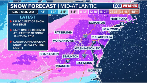
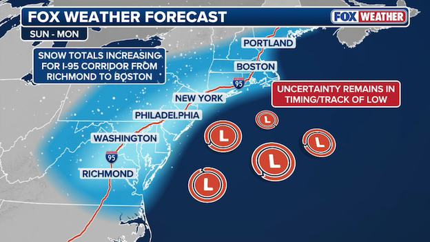
Latest snow forecast for the Mid-Atlantic and Northeast.
The FOX Forecast Center says the threat for heavy snow is increasing along I-95 and I-81 in the Mid-Atlantic and Northeast. It's been 10 years since Washington has seen at least 12 inches of snow from a storm, but that streak could end this weekend. Computer forecast guidance now suggests some spots from Virginia to Connecticut may pick up more than a foot of snow from the storm.
Winter Storm Watches are in effect for Louisville, KY to Memphis, TN for Friday through Sunday.
The National Weather Service wants to make sure Americans are prepared ahead of this weekend's winter storm. New Winter Storm Watches were just issued for portions of Kentucky, Indiana, and Illinois with forecasters warning of potential hazardous travel conditions later this week. As the storm approaches, the watches will be replaced with Winter Storm Warnings to highlight the impending storm.
Wednesday morning Global Forecast System (GFS) computer forecast model data. (Source: WeatherBELL)
Forecasters are closely analyzing the latest global computer forecast model (GFS) for trends in the track of the storm that could point to a shifting forecast. Data is pouring in right now and meteorologists at FOX Weather are stepping through each piece step-by-step to determine how the overall winter storm is evolving. Stay tuned for updates to the snow and ice forecast throughout the day.
United Airlines is waiving change fees for flights to and from 26 airports ahead of this weekend's big storm.
The FOX Forecast Center is awaiting new computer model guidance that will help drive updated forecasts for the afternoon. Giant supercomputers are ingesting vast amounts of current observation data from around the world right now and will begin spitting out new forecast models in the next 3 hours. That data will be used by meteorologists at FOX Weather to provide the most accurate and up-to-date forecast for this weekend's storm.
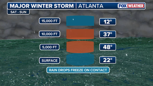
A warm layer of air aloft could lead to significant freezing rain for Atlanta.
The world's busiest airport could face big problems if freezing rain hits on Saturday. Hartsfield-Jackson Atlanta International Airport sees over 1,000 flights each day and a wintry mix of freezing rain or sleet would wreak havoc on airport operations. Computer forecast models have shown startling ice accumulation amounts for the Atlanta metro area in the past few days. A combination of rich, moist air flowing in from the south and frigid, arctic air from the north will create the perfect setup for freezing rain to fall.
Freezing rain happens when raindrops fall to the surface where temperatures are below freezing. This occurs thanks to a layer of warm air aloft in the atmosphere. Snowflakes falling from the clouds melt into raindrops when they reach this warm layer of air. Those raindrops then fall to the ground, but freeze instantly due to a layer of sub-freezing air near the surface.
There is big "bust" potential for Atlanta - meaning the city could see significant freezing rain and ice, or the rain line could shift north and lead to plain old rain in North Georgia. It'll be close as the rain-snow-freezing rain line will be setting up across the area. With the forecast details still uncertain, eyes will be on Atlanta and how the forecast will evolve in the hours ahead.
Widespread power outages could last for days across the Southeast.
A dozen states are at risk for significant ice from this weekend's winter storm. Ice building up on trees and power lines could bring them down, resulting in power outages for thousands of people. The FOX Forecast Center says the storm could drop "crippling amounts of ice" across the South, making travel impossible. And the ice will have lasting power, too. Frigid air will settle in across these areas after the storm, preventing the ice from melting and not lending a hand to crews trying to restore power.
If you've got travel plans this weekend, now is the time to start thinking of a backup plan. With a sprawling winter storm forecast to slam half of America, airports will be working overtime to clear snow and ice from runways and keep flights on time. But the storm will undoubtedly disrupt thousands of flights across the United States.
As of now, FlightAware reports 0 flight cancellations in and out of the U.S. on Friday. But as airlines pinpoint how the storm will impact their schedules, adjustments will be made, meaning flight cancellations will start adding up quickly.
FOX Weather is working to provide the most comprehensive winter storm coverage available to you. The team is working to deploy meteorologists and correspondents across the impact zone from the Plains to the Northeast to cover this impending storm. Live updates and around-the-clock coverage will continue through the weekend.
Confidence is increasing that a significant winter storm will impact the Interstate 95 corridor.
How much snow will New York get? Will I-95 travel come to a standstill? Are major Northeast airports going to see big cancellations? These are all questions that still need answers as the storm's evolution becomes more clear.
Forecasters are closely monitoring trends in how the different ingredients are coming together thousands of miles away from the East Coast and how computer forecast guidance is modeling those ingredients. Right now, it's still too early to say exactly how much snow will fall along I-95 in the Northeast corridor, but confidence is increasing that a plowable snow event is about to occur this weekend.
Because the track of the overall storm and its individual pieces remain unclear, there's no way to determine exactly how much snow will fall and when. The FOX Forecast Center is analyzing new forecast data this morning and will be updating the snow forecast later today.
Delta Airlines just issued a travel waiver for this weekend's impending storm. It impacts 41 airports on January 23-25.
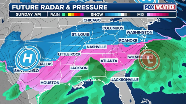
Future radar shows widespread snow, ice, and freezing rain impacting millions of Americans on Sunday.
America's next winter storm will be monstrous. According to the FOX Forecast Center, more than half of America will see snow, sleet, and/or freezing rain simultaneously when the storm reaches its peak on Sunday. Forecast trends show a growing threat farther north that could impact major cities from the Midwest to the Northeast.
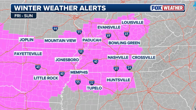
Winter Storm Watches are now in effect for nearly 30 million people across a dozen states.
With confidence increasing in a significant winter storm happening later this week, the National Weather Service has expanded its alerts across the Mid-South. Winter Storm Watches are now up for nearly 30 million Americans from New Mexico to Alabama in anticipation of snow and ice that could disrupt travel. The watch means a winter storm is possible in the next few days and provides an early warning for people to prepare. As we approach the beginning of the snow and ice, these watches will be replaced with Winter Storm Warnings.
Winter Storm Watches are being issued ahead of this week's winter storm.
National Weather Service offices across the Plains and Southeast are getting ahead of this week's winter storm. Winter Storm Watches are now up for 12 states, putting millions on alert for potentially disruptive winter weather that could create hazardous travel conditions. Additional alerts are expected later today.
This trend really has little to no impact on the fact that a widespread and significant winter storm is going to occur... but it does play a big factor in exactly where the rain/ice/snow lines set up.
Meteorologists at the Weather Prediction Center are weighing in on the northern shift in the computer forecast model guidance overnight. Their focus is on the energy that will phase together to spawn this monster winter storm and how that energy is still thousands of miles away. Forecasters say until this energy gets better organized and moves closer to the U.S., the exact details of where the heaviest snow and ice will accumulate won't be settled.
Latest FOX Weather ice forecast for the Southeast U.S.
When you hear "winter storm," most people think of snow. But anyone in the South would tell you it's not all about the flakes. Ice is always a big concern when mild, moist air is predicted to collide with arctic air. Forecasters are warning that this week's storm could put down more than a half inch of ice in the Ark-La-Tex region stretching to the Carolinas. This dangerous ice could pull down power lines, knocking out power to thousands of people. And it could cripple communities by turning roads into an ice rink.
The FOX Forecast Center says this forecast is still subject to change, so keep watching for updates.
FOX Weather snow forecast for a colossal winter storm set to slam the South and East.
A sprawling winter storm is expected to dump snow across 30+ states starting on Friday and lingering into early next week. FOX Weather's latest snow forecast calls for more than a foot of snow falling in spots from Oklahoma to the Mid-Atlantic states. Forecasters say this is an early draft of what to expect this weekend as the numbers will likely go up or down as the finer details of the storm become more clear in the next 48 hours.
Computer forecast models showing forecast differences from Tuesday to Wednesday. Source: WeatherBELL
Forecasters are waking up and quickly assessing how computer forecast models changed overnight in their handling of this week's winter storm. As the FOX Forecast Center cautioned yesterday, this forecast is nowhere near being locked in, meaning there are some finer details that have yet to be resolved and that could have implications on the forecast itself.
The latest computer forecast guidance shifted overnight, showing the storm tracking farther north than previously modeled. This doesn't mean the South will be spared, but it could mean the far-reaching impacts are felt in areas farther north than originally expected.
FOX Weather meteorologists are analyzing this new data now to determine how this shift would impact Americans from the Plains to the Northeast. Keep watching for updates.
You can go back and see how the forecast for this winter storm has evolved with our live coverage from Tuesday.
Live Coverage begins here