Live updates: Extreme winter storm developing, threatening 40 states with heavy snow, crippling ice
Live updates: Extreme winter storm developing, threatening 40 states with heavy snow, crippling ice
Download the AppLIVE Winter Storm HQ Coverage continues
View postCoverage for this event has ended.
LIVE coverage has ended here, but FOX Weather is providing around-the-clock updates through the weekend.
Data from FlightAware shows airlines have canceled 1,200+ flights across the U.S. through Saturday. Right now, airlines are working to adjust schedules as a dangerous winter storm prepares to dump snow and ice across 40 states.
Airlines are making major adjustments to their schedules in preparation of this weekend's major winter storm. With extreme winter weather forecast to slam major airports from the South to the Northeast, operations will grind to a halt as crews work to keep runways clear. So far, nearly 800 flights have been canceled in the U.S. through Saturday - and that number is expected to climb into the thousands.
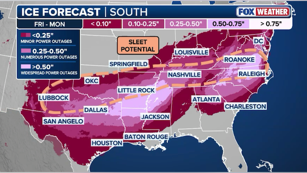
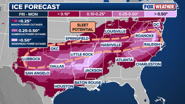
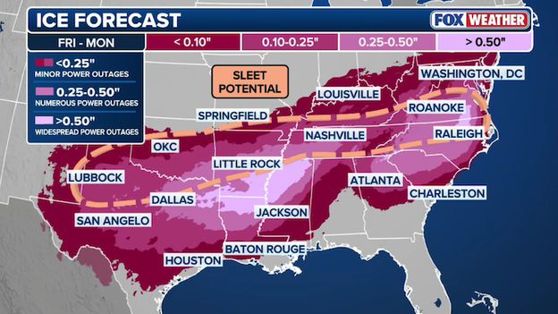
Latest ice forecast from the FOX Forecast Center showing dangerous ice accumulating across the South.
Final preparations should be underway ahead of the massive winter storm set to coat a dozen states in dangerous ice. The newest ice forecast from the FOX Forecast Center doesn't have any major surprises. Crippling amounts of ice are expected from Texas to Tennessee and from the Carolinas to Virginia. This much ice accumulating on roads will create treacherous travel conditions, even making travel impossible in some areas. Utility crews are also gearing up for widespread power outages due to the severity of the ice.
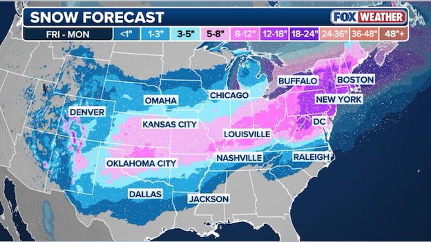
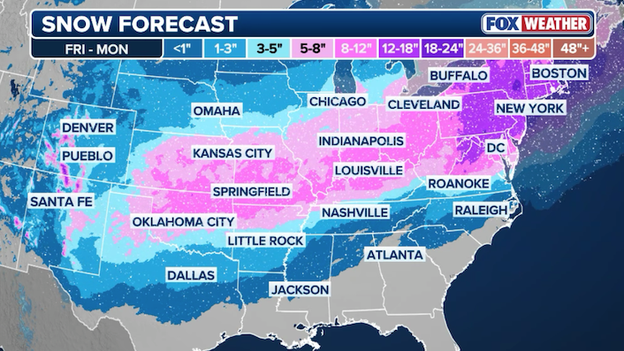
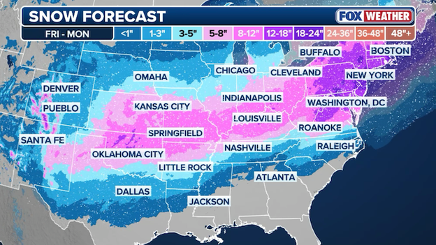
Latest snow forecast from the FOX Forecast Center showing the extent of this major winter storm.
We're just hours away from the start of this brutal winter storm's 2,000+ journey across America and the snow forecast remains on track. The FOX Forecast Center just released an updated snow forecast and there are no major changes. Significant snow will pile up from the Plains to New England over the next few days.
Alabama Governor Kay Ivey has declared a State of Emergency for 19 counties amid the massive winter storm brewing.
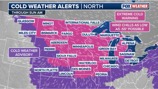
Extreme Cold Warnings and Cold Weather Advisories are in effect from the Plains to the Northeast.
America is facing life-threatening cold weather in the next 48 hours. Temperatures are expected to dip to near -30F in parts of the Northern Plains and Midwest, but it's the wind that will create dangerous wind chill readings in this part of the nation. Wind chills could drop to -55F across North Dakota, Minnesota, and Wisconsin as gusty winds combine with the frigid air. Extreme Cold Warnings and Cold Weather Advisories are in effect for 167 million Americans from the Plains to the Northeast in anticipation of this extreme cold.
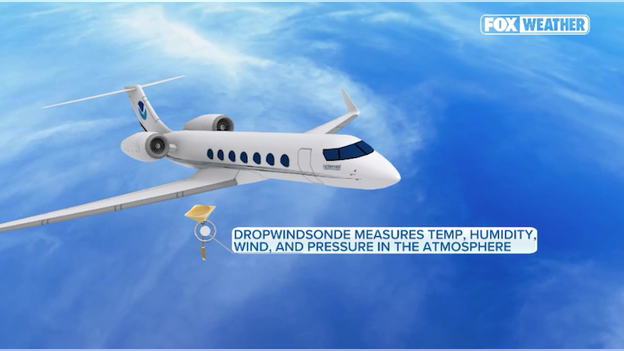
NOAA's Gulfstream IV flies high up into the atmosphere to see how storms are developing.
Getting a good forecast starts with getting good observations. And that's why the Weather Prediction Center has called upon the Hurricane Hunters for help. A NOAA Gulfstream IV just took off from its base in Lakeland, FL to head toward the developing winter storm. It's goal is to sample the atmosphere from top to bottom ahead of the storm so that computer forecast models can get the most clear picture of how things are coming together. The Hurricane Hunters often fly into major winter storms and atmospheric rivers to give forecasters better data that has been proven to improve forecasts.
FlightAware tracking shows major U.S. airlines are actively canceling flights at big airports ahead of the storm.
Major U.S. airlines have been preparing for this week's winter storm for days, and now they're putting those plans into motion. In anticipation of the snow and ice blasting airports across the country, airlines have started canceling flights ahead of the storm. Data from FlightAware shows more than 240 flights have been canceled across the U.S. on Friday and Saturday. That number is expected to climb into the thousands over the weekend, so if you're flying anywhere in the next few days, be prepared for big travel trouble.
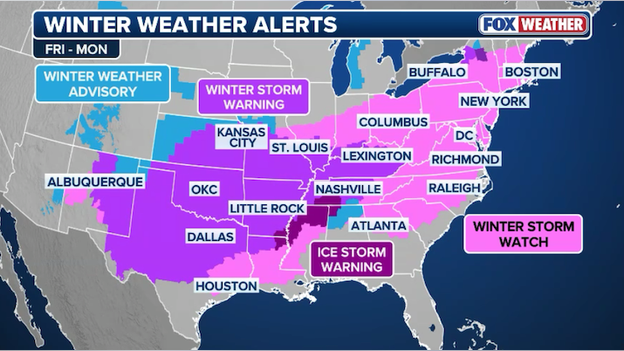
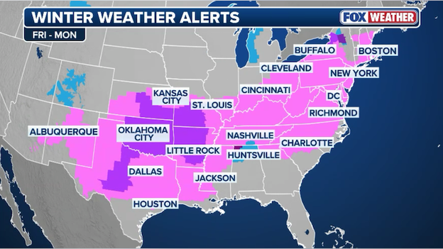
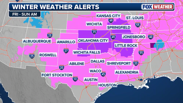
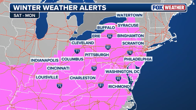
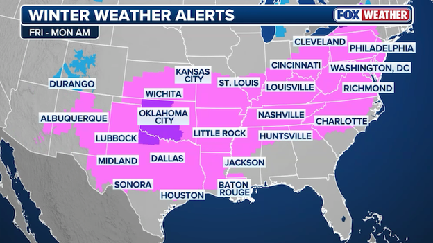
Map showing winter weather alerts spanning from the Desert Southwest to New England.
175 million Americans are now under some sort of winter weather alert - covering more than 2,000 miles from Arizona to Maine. Winter Storm Warnings are being issued across the nation's midsection with the storm expected to begin dumping snow and ice tomorrow. The East Coast won't see snow until Saturday night and Sunday where Winter Storm Watches are currently in effect. Those will be replaced with warnings in the next 36 hours.
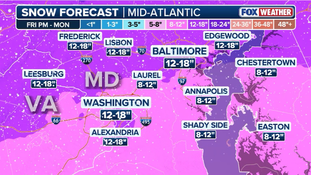
Latest snow forecast from FOX Weather for Washington and Baltimore.
The nation's capital could get buried this weekend if the current forecast holds. Right now, the FOX Forecast Center says more than a foot of snow could fall in and around Washington and Baltimore starting on Sunday. That snow could disrupt flights at major airports and bring travel to a standstill on major interstates.
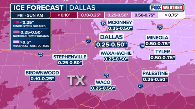
Latest ice forecast from FOX Weather for the Dallas-Fort Worth area.
Freezing rain is expected to coat North Texas and the Dallas-Fort Worth Metroplex with considerable ice starting late Friday. That ice will coat everything - roads, cars, trees, power lines - and could make travel impossible. The weight of that ice will also bring down trees and power lines, knocking out power in many areas. Texans should be preparing now for widespread power outages that could last into next week.
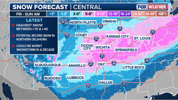
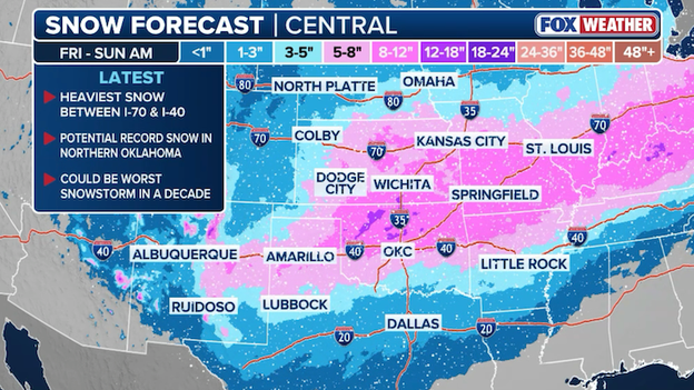
Latest snow forecast from FOX Weather for the Central U.S.
The Show-Me State is getting ready to show off a lot of snow in the next few days. Some spots across Missouri, Kansas, and Oklahoma could pick up nearly a foot of snow through the weekend. Travel along I-35, I-40, and I-70 will become difficult as the snow piles up starting late Friday and lingering into Sunday.
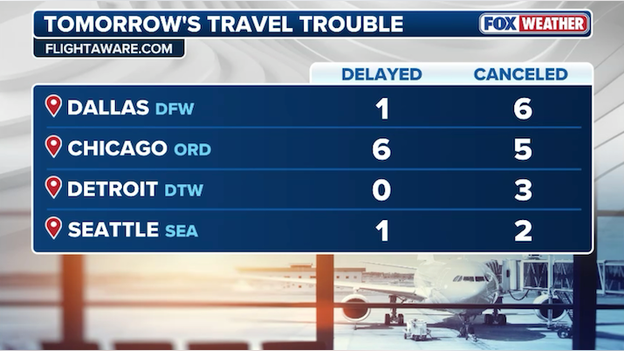
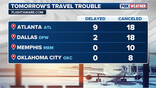
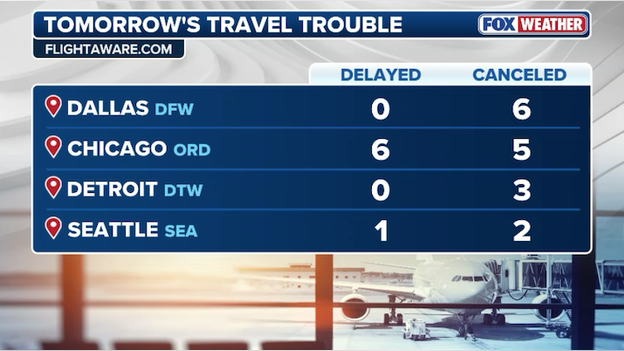
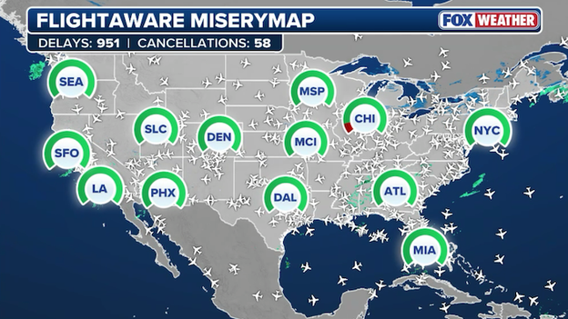
Top delays and cancellations at major U.S. airports on Friday.
U.S. airlines are starting to adjust schedules as a massive winter storm develops. Data from FlightAware now shows more than 100 flights have been canceled on Friday and Saturday. Thousands of flights are expected to be disrupted through early next week.
Virginia Governor Abigail Spanberger has issued a State of Emergency. A state of emergency is a formal declaration by a governor that conditions are severe enough to require state-level coordination and resources to support local response efforts.
Texas Governor Greg Abbott has issued a disaster declaration for 134 counties as a "severe" winter storm prepares to sweep across the state, bringing life-threatening temperatures and hazardous wintry weather beginning Friday and lasting through the weekend.
The National Weather Service has issued a Cold Weather Advisory for New York City, the first since the advisory was introduced in October 2024. That advisory is in effect Friday night into Saturday morning when wind chills could dip to -5F. Wind chills this low could lead to frostbite and hypothermia if unprotected skin is exposed for any prolonged period of time.
Friday's top flight disruptions at major airports in the United States.
The latest data from FlightAware shows major U.S. airlines have begun to cancel flights on Friday ahead of the developing winter storm. Conditions are expected to deteriorate rapidly across the Central U.S. through the day, which will slow down operations at many airports. As operations slow down, airlines will need to cancel flights in order to meet restrictions set by each airport and the Federal Aviation Administration. These numbers are expected to quickly increase over the next 24 hours with thousands of flight disruptions expected over the weekend.
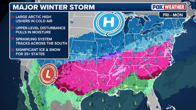
A dangerous winter storm is taking shape that will slam 40 states and 235+ million Americans with snow and ice.
More than 235 million Americans are facing one of the worst winter storms to hit the United States in years. More than a foot of snow is expected to bury some states, while freezing rain and sleet could grind travel to a halt and knock out power to thousands of people. This massive winter storm will start its 2,000+ mile journey on Friday in the Plains, reaching America's East Coast by Sunday. Cities such as New York, Washington, Atlanta, and Dallas are gearing up for what is expected to be an extreme winter storm that will deliver a one-two punch of snow/ice and then life-threatening cold air across the nation.
Winter weather alerts cover much of the nation's Heartland to the Northeast at this hour.
Talk about a massive storm - winter weather alerts now cover 32 states from the Southwest to the Northeast, hours before an extreme winter storm begins to dump heavy snow and ice across America.
The National Weather Service has just issued a Winter Storm Watch for New York City, Long Island, and most of the Northeast from Saturday night through Monday afternoon. The watch calls for heavy snow with a mix of sleet and freezing rain for a time Sunday night especially closer to the coast. More than a foot of snow could fall across the area.
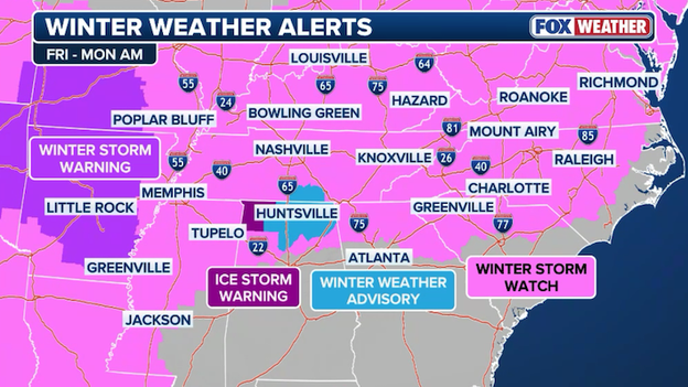
Winter weather alerts span across the South with a newly issued Ice Storm Warning in Alabama.
The National Weather Service in Huntsville, AL just issued the first Ice Storm Warning ahead of this weekend's storm. The warning states that significant ice accumulation is expected on power lines and tree limbs, which may cause widespread and long-lasting power outages. People should expect power outages that last more than a day and extensive tree damage due to the ice. It goes on to say that travel could become impossible Friday night through Sunday.
Latest winter weather alerts across the Central and Southern Plains of the United States.
With less than 24 hours before the first flakes fall in America's Heartland, the National Weather Service is replacing Winter Storm Watches with Winter Storm Warnings. The warnings mean hazardous winter weather is imminent or is already occurring. Additional warnings are expected throughout the afternoon for much of this region.
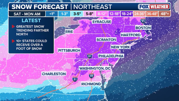
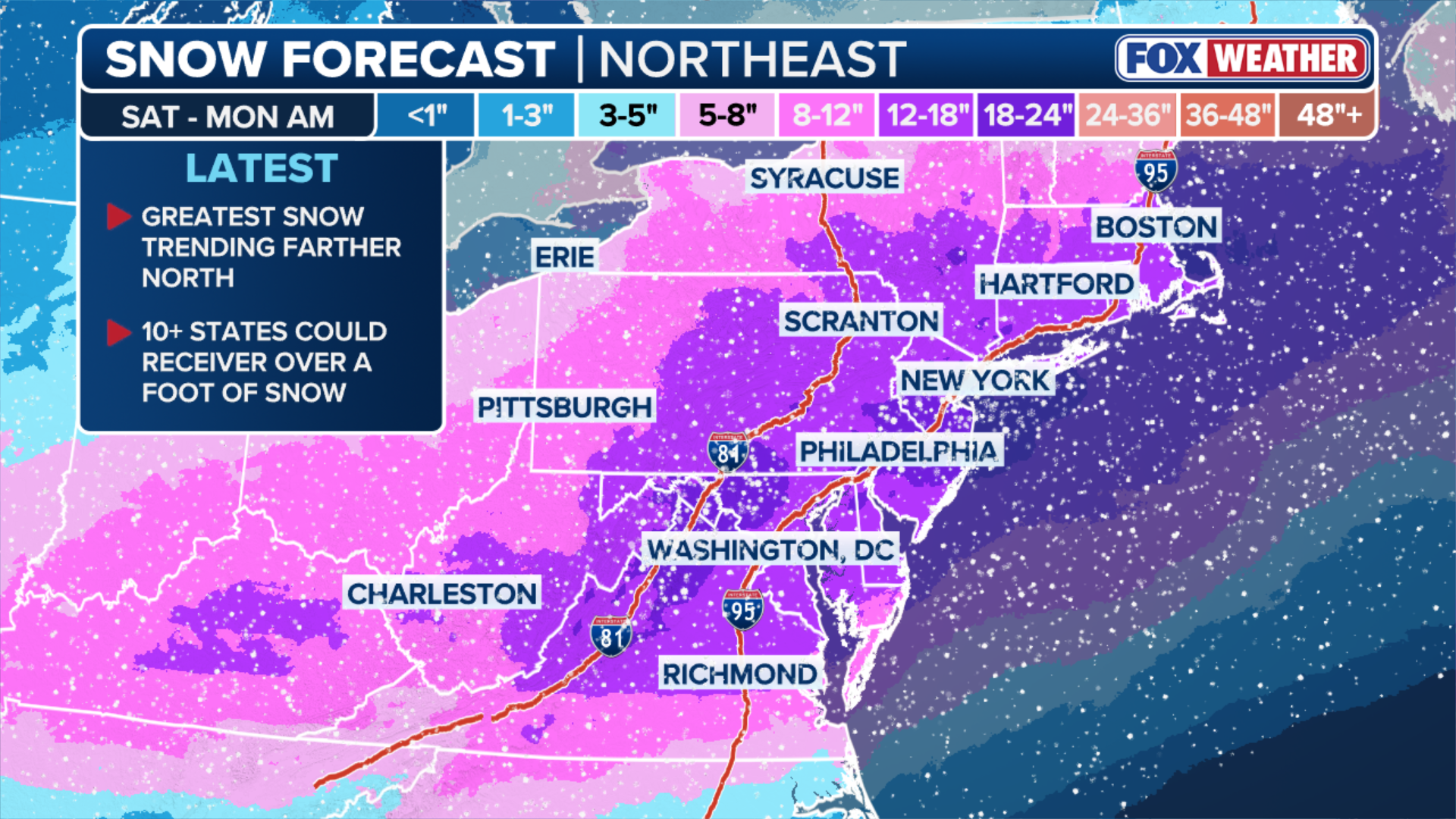
Latest snow forecast from FOX Weather showing more than a foot of snow falling in the Northeast.
New York, Boston, and Philadelphia are now gearing up for the biggest snowstorm to hit the Northeast in years. FOX Weather is calling for 12"+ of snow to fall across a big chunk of the region starting late Saturday and continuing into Monday. Meteorologists are closely tracking a coastal low that will develop off the East Coast, fueling the snow throughout the region. The snow forecast is still subject to changes as the storm system evolves in the next 48 hours.
Latest ice forecast from FOX Weather showing dangerous amounts of freezing rain across the South.
While millions are bracing for the most snow they've seen in years, others are gearing up for an ice storm. FOX Weather just released an updated ice forecast, showing crippling amounts of ice for portions of the South. From Dallas to Little Rock to Memphis, the ice could be significant enough to pull down trees and power lines, resulting in widespread power outages. Freezing rain is expected all the way to the East Coast where the Carolinas could also see major icing through the weekend.
Latest snow forecast issued by the FOX Forecast Center.
Big snow across a big chunk of the country. That's the messaging from the FOX Forecast Center with this morning's newly issued snow forecast. That forecast calls for nearly a foot of snow to fall from the Plains to the Northeast, with parts of the Northeast seeing nearly two feet of snow through early next week.
We're digesting this newest forecast map now and will post additional updates for various regions of the nation shortly.
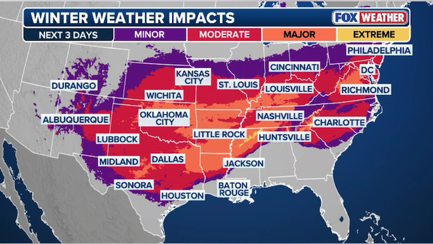
Winter weather impacts map showing moderate-major threat for millions of Americans.
Millions of Americans are facing "moderate" to "major" winter weather impacts starting on Friday and lingering into early next week. Travel may become treacherous to impossible at times and widespread power outages appear likely across multiple states.
The FOX Forecast Center is awaiting new computer model guidance that will help drive updated forecasts for the afternoon. Giant supercomputers are ingesting vast amounts of current observation data from around the world right now and will begin spitting out new forecast models in the next few hours. That data will be used by meteorologists at FOX Weather to provide the most accurate and up-to-date forecast for this weekend's storm.
FlightAware MiseryMap showing few disruptions across America right now.
FlightAware's MiseryMap is mostly "green" right now, indicating few air travel disruptions. That will change dramatically in the next 24 hours as airlines begin canceling hundreds of flights across the U.S.
Airports are preparing now by readying snow removal equipment and deicing trucks to keep planes moving. But the storm will inevitably slow down operations at dozens of major hubs from the Midwest to the East Coast, forcing airlines to adjust schedules and cancel flights. Most major airlines have already issued travel waivers ahead of the storm, eliminating change fees for those affected by flight disruptions. If you are traveling this weekend, now is the time to prepare a backup plan in case your flight is canceled.
I urge everyone to make their own preparations to ensure they and their families can remain safe over the coming days, especially if road conditions prevent travel.
Georgia Governor Brian Kemp has declared a statewide State of Emergency ahead of the winter storm expected to impact the state. According to the state, the executive order authorizes the Georgia Emergency Management and Homeland Security Agency (GEMA/HS) to activate the State Operations Center (SOC) and mobilize any needed resources to address potential impacts.
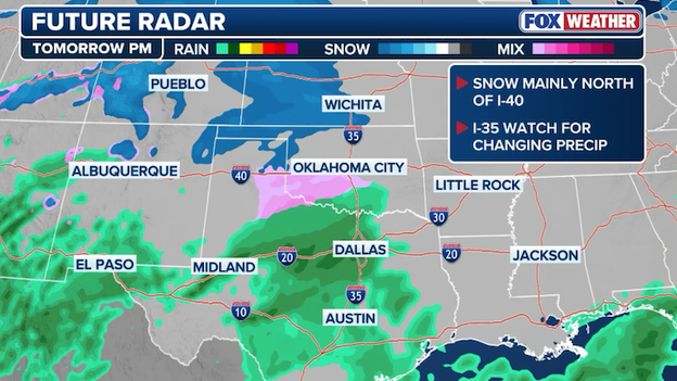
Future radar map showing snow and a wintry mix developing across the Plains on Friday afternoon.
America's massive winter storm starts in less than 24 hours and it all begins in the nation's Heartland. Snow and a wintry mix of freezing rain and sleet are expected to begin falling on Friday afternoon, worsening through the evening and overnight hours.
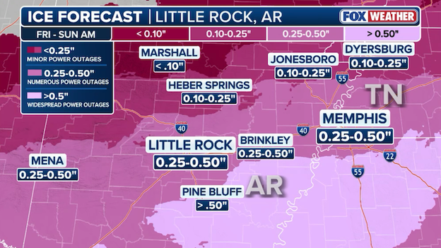
Latest ice forecast for Little Rock, AR and Memphis, TN through the weekend.
The FOX Forecast Center says the amount of ice expected to accumulate in the Ark-La-Tex region could be crippling. Places like Little Rock and Memphis could see widespread power outages and tree damage with more than .25 inch of ice expected this weekend.
We’re about to experience some of the coldest weather Connecticut has had in quite a while, and it cannot be stressed enough that temperatures this low can be fatal if someone is outside for too long.
Governor Ned Lamont has announced that he is activating Connecticut’s Severe Cold Weather Protocol beginning Friday. The state says the protocol is designed to ensure that the most vulnerable populations receive protection from the severe cold.
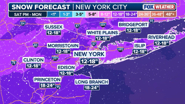
Latest snow forecast for the New York City metro area from FOX Weather.
America's most-populated city is now looking at its worst snowstorm in years. The latest forecast from FOX Weather calls for more than a foot of snow to fall in and around the New York City metro area. The snow would grind travel to a halt for millions along I-95.
FOX Weather meteorologists caution that this forecast is subject to change since the storm is still several days away - the snow doesn't even arrive until Sunday. Changes in the track of the storm, the development of the coastal low, and other factors will result in the snow forecast going up or down in the days ahead.

Latest power outage forecast map showing the potential for widespread outages across the South.
State leaders and emergency management officials across the South are urging people people to prepare for power outages this weekend. With the threat of significant ice accumulating in many areas, power lines may topple and knock out power for thousands of people. And there's growing concern that these outages could last for days. Frigid air will settle in after the storm, preventing any ice from melting, which would make it tough for utility crews to restore power.
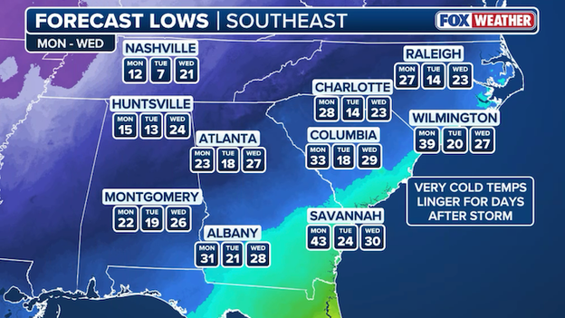
Forecast low temperatures for the Southeast through next early week.
While all eyes are on the threat for heavy snow and ice in the days ahead, we don't want to forget about the brutally cold air coming in behind the storm. Arctic air will blast the Southeast after the snow and ice ends, lingering for days in many places.
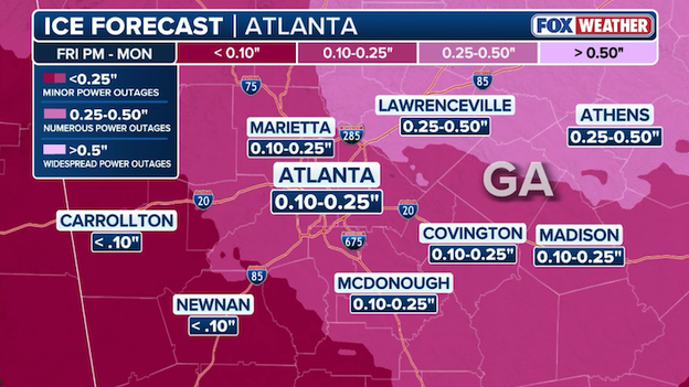
Latest ice forecast for the Atlanta metro area from the FOX Forecast Center.
While the finer forecast details become more clear, Atlanta is not out of the woods when it comes to impacts from this weekend's winter storm. The latest ice forecast from the FOX Forecast Center still calls for up to .25" of ice in and around the Atlanta metro and North Georgia. While 1/4 inch of ice doesn't seem like much, just a few hundredths of an inch of ice can turn roads into an ice rink. That ice could also lead to numerous power outages throughout the area.
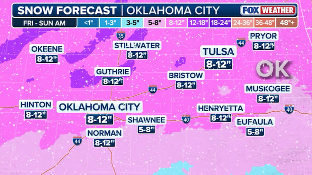
Latest snow forecast for the Oklahoma City metro area from FOX Weather.
Oklahoma City is bracing for one of its biggest snowstorms on record. The latest forecast from the FOX Forecast Center calls for 8-12" of snow in the OKC metro area through the weekend.
I am directing the Department of Emergency Management to coordinate the comprehensive preparation of State government ahead of potential impacts related to the incoming weather system.
Maryland Governor Wes Moore says the safety and security of Maryland residents is his top priority. On Wednesday, the Governor declared a State of Preparedness, which he says enhances the State’s ability to respond swiftly and effectively to potential hazards and threats before escalating response.
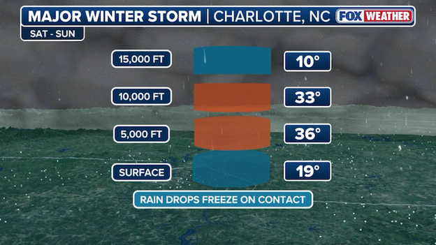
Vertical temperature profile of the atmosphere above Charlotte, NC this weekend.
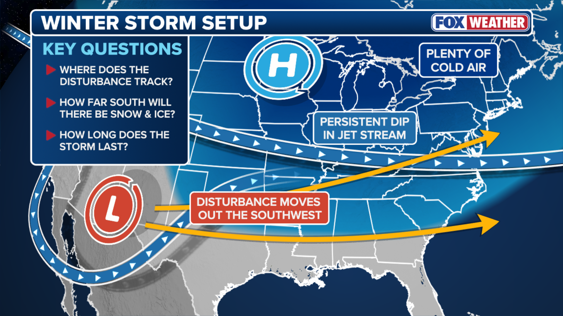
FOX Weather meteorologists are closely analyzing the atmosphere to determine how this winter storm will pan out across the East. Frigid air will collide will moist, mild air from the south and result in big snow and ice across many states. But forecasters aren't just watching the temperature at the surface - they're looking thousands of feet up for trouble.
Charlotte, NC is just one of the places that could see significant freezing rain and ice from this weekend's storm. And that's thanks to a warm air aloft. The air temperature near the ground, where we all live, will be cold. But just a few thousand feet up, the air temperature will climb above freezing. This layer of warm air from 5,000 to 10,000 feet up is why freezing rain is such a big concern. As snowflakes fall from the clouds, they'll encounter this layer of warm air and melt into raindrops. Those raindrops will then fall to the ground, but freeze immediately into ice as they hit the surface. Only a few hundredths of an inch of ice can turn roads into a mess. This weekend's forecast calls for upwards of .50" of ice -- a recipe for disaster.
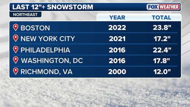
Major cities along I-95 haven't seen a big snowstorm in several years.
New Yorkers will tell you: it's been a minute since the city has seen a big snowstorm. The FOX Forecast Center says the last 12"+ snowstorm in New York was back in 2021. And Washington hasn't seen more than a foot of snow from a single storm in 10 years. With the latest forecast calling for nearly a foot of snow along I-95, these streaks may come to an end in just a matter of days.
Winter Storm Watches are in effect for most of the Mid-Atlantic and parts of the Northeast.
Winter weather alerts now span nearly 2,000 miles across America from Arizona to New York. The National Weather Service has issued Winter Storm Watches for portions of the Mid-Atlantic and Northeast, including Washington and Philadelphia, starting Saturday. The watch means hazardous winter weather is expected and now is the time to prepare.
New York and Boston are not under any weather alert at this time, but we expect that to change later today as confidence increases in the threat to these areas.
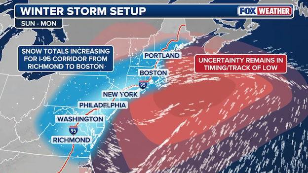
A coastal low will play a key role in determining how much snow will fall in the Northeast.
Anyone claiming they know exactly how much snow will fall in places like New York and Boston this weekend is lying. Even the best meteorologists using the most sophisticated forecast models and Artificial Intelligence technology would tell you the forecast isn't locked in yet. We are still a few days out from this dynamic winter storm even reaching the East Coast and there are some key pieces of the puzzle that must be resolved.
In the past 48 hours, the trend has indeed been upwards for snow amounts along I-95 in the Mid-Atlantic and Northeast. Once the storm shifts from the Plains to the East Coast, it will trigger a coastal low to form and it's that low that will fuel intense snow in major cities along I-95. There remains some uncertainty as to how strong the low will actually get, when it will form, and how long it will stay close to the coast. FOX Weather meteorologists are analyzing new forecast data every few hours to provide the most accurate and reliable snow forecast. Bottom line: the threat for more than a foot of snow in the Northeast is increasing.
Travel trouble is expected across 35 states this weekend as snow and ice pile up - and it's not just the roads that will get slick. Airports in the path of the winter storm are preparing now, readying snow removal equipment and deicing trucks to keep planes moving. But the storm will inevitably slow down operations at dozens of major hubs from the Heartland to the East Coast, forcing airlines to adjust schedules and cancel flights.
Right now, FlightAware shows only a dozen flight cancellations across the U.S. for Friday. That number is expected to go up as forecasters finalize snow and ice forecasts today. Most major airlines have already issued travel waivers ahead of the storm, eliminating change fees for those affected by flight disruptions. If you are traveling this weekend, now is the time to prepare a backup plan in case your flight is canceled.
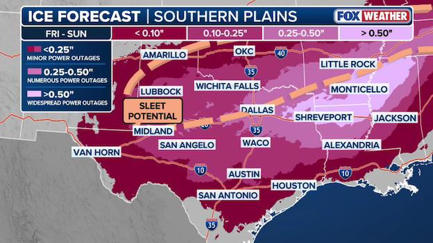
Latest ice forecast for the Ark-La-Tex region showing where significant freezing rain is likely.
FOX Weather meteorologists are growing increasingly concerned with freezing rain and ice building up across Texas into Arkansas and Mississippi. It only takes a few hundredths of an inch of ice to make roads slick and the latest forecast shows more than a half inch of ice could accumulate in these areas. That much ice is heavy enough to weigh down trees, breaking off branches, and taking down power lines. Travel is expected to become treacherous in these areas and power outages could last for days.
Latest snow forecast for the Central and Southern Plains of the United States.
Meteorologists in the FOX Forecast Center say this could be one of the worst snowstorms to hit the Plains in a decade. With more than a foot of snow expected to pile up across Oklahoma and Kansas, records may even be broken. Right now, the worst snow is expected between Interstate 70 and Interstate 40. The snow begins on Friday and is expected to wind down early Sunday.
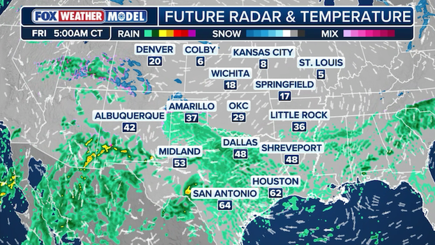
Exclusive FOX Weather Model shows showers popping up across Texas on Friday morning.
Friday morning will start with plain old rain falling in Texas, but as colder air sweeps in through the morning, that rain will begin to change over to freezing rain, sleet, and snow. The exclusive FOX Weather Model shows just that: showers across Texas early in the morning with temperatures in the 40s, 50s, and 60s. By afternoon, conditions will deteriorate rapidly as that colder air arrives and the rain changes to a wintry mix.
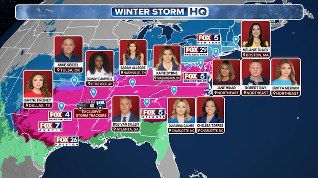
FOX Weather is deploying a team of meteorologists and correspondents across America for the winter storm.
FOX Weather is providing LIVE, around-the-clock coverage of the extreme winter storm. With more than 20 crews deploying into the storm, this is the place for the most comprehensive storm coverage. Our team of meteorologists and correspondents will be Weathering It Together with you, reporting on the latest LIVE developments as the storm unfolds.
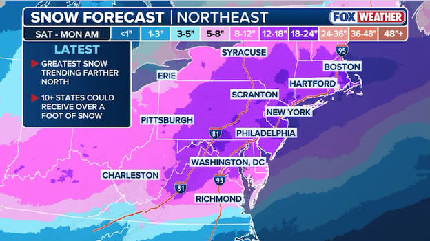
America's heavily-traveled I-95 corridor could see more than a foot of snow through Monday.
Millions of Americans living in the Mid-Atlantic and Northeast could see one of the biggest snowstorms in years this weekend. The latest forecast from the FOX Forecast Center shows 10+ states could see more than a foot of snow, including New York, Boston, and Philadelphia. Anyone living along the I-95 corridor should pay close attention to the forecast in the next 48 hours. With the storm just beginning to form in the West, the forecast snow amounts are subject to change as forecasters see how the storm evolves.
Updated snow forecast map shows heavy snow spanning from the Heartland to the Northeast.
The FOX Forecast Center just put out an updated snow forecast for the developing winter storm. No major shifts in the overall storm track have been observed in the overnight forecast data, so there are no significant changes in this updated forecast. However, it does show increasing confidence that a major snowstorm will bury parts of the Northeast and I-95 corridor in more than a foot of snow from Sunday into Monday.
Latest ice forecast from FOX Weather for the Friday to Monday winter storm.
The FOX Forecast Center just released a new ice forecast map for the weekend. It shows no major changes in the overall forecast - significant ice expected to accumulate from Texas to Tennessee and across the Carolinas. What remains to be seen is just how much sleet will mix in with the freezing rain across these areas, which could limit the amount of ice that accumulates.
On Wednesday, both North Carolina Josh Stein and South Carolina Governor Henry McMaster declared a State of Emergency in preparation of this weekend's winter storm. With snow and ice expected to coat both states, emergency management officials aren't wasting any time in getting ready.
The Electric Reliability Council of Texas (ERCOT) has issued a Weather Watch from Saturday, January 24 to Tuesday, January 27. ERCOT says the winter storm and expected cold temperatures will result in higher electrical demand and the potential for lower reserves. It says grid conditions are expected to be normal. In a press release, ERCOT says it is monitoring weather conditions closely and will deploy all available tools to manage the grid.
The FOX Forecast Center is finalizing updated snow and ice forecasts based on fresh forecast data from overnight. Minor shifts in the overall storm track will result in snow/ice totals going up or down in some spots. As soon as the new forecasts are available, we'll post them here.
Winter Storm Watches and Warnings span nearly 2,000 miles ahead of the developing winter storm.
More than 133 million Americans are now under some type of winter weather alert. The National Weather Service just issued the first Winter Storm Warnings for the storm across Oklahoma and North Texas. The warning starts at 6 a.m. CT Friday and ends at noon CT on Sunday. NWS Norman is warning that travel may be extremely dangerous and is urging people to stay inside until conditions improve.
Additional warnings are expected to be issued across the Plains states later today.
You can go back and see how the forecast for this winter storm has evolved with our live coverage from Wednesday.
You’ve reached the beginning of this live coverage.