Live updates: Vicious storms target the Northeast after derecho blasts the Midwest with 90 mph winds
Live updates: Vicious storms target the Northeast after derecho blasts the Midwest with 90 mph winds
Download the AppTop Wind Gusts: Hurricane-force winds reported in Midwest during severe weather outbreak
View postCoverage for this event has ended.
Amid a severe weather outbreak ripping through the Midwest, good news has come from one hard-hit area in Illinois.
City officials in Streator, Illinois, say there have been no reported fatalities after a tornado moved through the area Thursday afternoon, causing damage in several parts of the community.
In an update issued Thursday evening, city leaders confirmed a tornado touched down in the Streator area and said emergency crews were actively assessing the extent of the damage.
Residents were urged to avoid impacted areas to allow first responders and utility crews to safely conduct recovery operations.
Mayor Tara Bedei said there were no reported fatalities following the storm and thanked emergency personnel for their rapid response.
“At this time, there are no reported fatalities, and we are incredibly grateful for the safety of our residents and the quick action of emergency personnel, both in Streator and regionally,” Bedei said.
City officials cautioned residents to use extreme care when traveling through affected areas, warning that debris and other hazards may still be present.
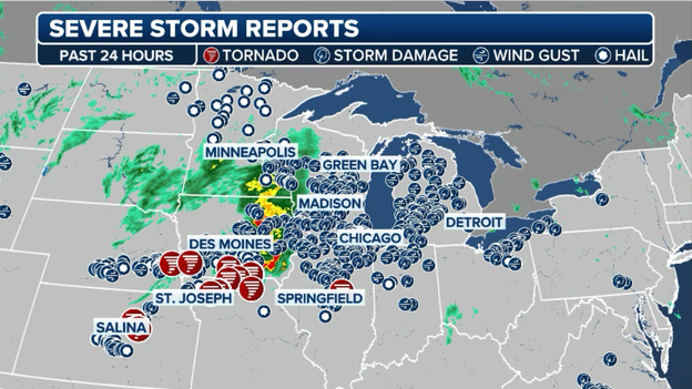
A significant severe weather outbreak continues to unfold across the Midwest, with dangerous thunderstorms producing tornadoes, destructive wind gusts and large hail ongoing across the region.
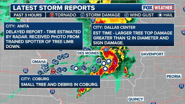
Latest storm reports highlight the widespread severe weather threat over the past six hours as storms continue to expand across the Midwest.
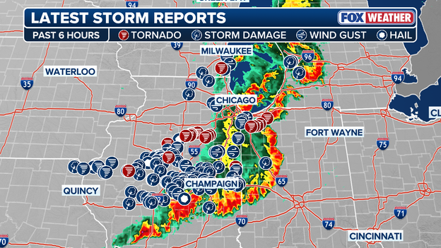
Latest Storm Reports
The severe weather threat is expected to continue for several more hours before gradually shifting east overnight.
FOX Weather will continue to monitor the outbreak and provide updates as new warnings, watches and storm reports are issued.
A confirmed large and extremely dangerous tornado was moving through northwestern Indiana on Wednesday evening, prompting forecasters to issue a Particularly Dangerous Situation (PDS) Tornado Warning.
At 8:32 p.m. CDT, the tornado was located over Wanatah, or about 7 miles southeast of Westville, and was moving northeast at 35 mph. Weather spotters confirmed the tornado, which the National Weather Service warned was capable of causing catastrophic damage.

Confirmed Tornado
"This is a particularly dangerous situation. Take cover now!" forecasters said in the warning.
Residents in the path of the tornado were urged to seek shelter immediately in a basement or an interior room on the lowest floor of a sturdy building and avoid windows.The warning highlighted the potential for flying debris that could be deadly to anyone caught without shelter.
Mobile homes were expected to be destroyed, while considerable damage to homes, businesses and vehicles was likely. Complete destruction was also possible.
Communities in the storm's path included La Porte, Westville, Kingsford Heights, Wanatah, Hamlet, Hanna, Kingsbury and Thomaston.
FOX Weather will continue to provide updates as the situation unfolds.
A confirmed tornado tore through Streator, Illinois, on Wednesday as severe thunderstorms swept across the Midwest, leaving behind "heavy damage" and prompting an emergency response across the north-central Illinois community.
Authorities also announced that Illinois Route 18 entering Streator was closed due to storm damage and hazardous conditions.
The tornado spawned as a powerful severe weather outbreak unfolded across parts of the Midwest, where thunderstorms produced damaging winds, large hail and multiple tornado warnings throughout the day.
Severe storms blasted parts of the Midwest and Mid-Atlantic on Wednesday, producing damaging wind gusts that topped out at 75 mph in Illinois.
According to FOX Weather's top wind reports, the strongest gust of the day was recorded in Mason City, Illinois, where winds reached 75 mph. Ames, Iowa, and Lower Burrell, Pennsylvania, each reported gusts of 72 mph.
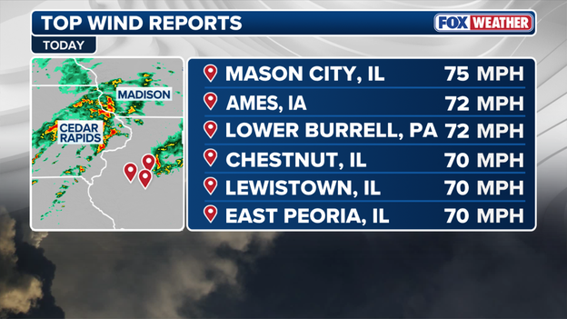
Top Wind Reports
Several other Illinois communities were also hit hard by the storms, including Chestnut, Lewistown and East Peoria, where peak wind gusts reached 70 mph.
The reports come as a line of thunderstorms swept across portions of Iowa, Illinois and neighboring states. Strong winds of this magnitude can down trees, damage power lines and cause localized power outages.
Washington, D.C., along with a corridor encompassing Arlington and Alexandria, Virginia, is now under a Severe Thunderstorm Warning through 8:30 p.m. EDT.

Severe Thunderstorm Warning area
Roughly 6.2 million people are under threat as strong thunderstorms bring the potential for pea-sized hail and damaging wind gusts of up to 60 mph.
Impacted areas should be prepared for damaging wind gusts, torrential downpours, and frequent lightning as a line of strong thunderstorms pushes through the region this evening.
More than 47 million are under Severe Thunderstorm Watch till midnight for portions of Delaware, Maryland, New Jersey, New York, Pennsylvania and Virginia through midnight EDT as a line of strong to severe thunderstorms races across the Mid-Atlantic and Northeast.
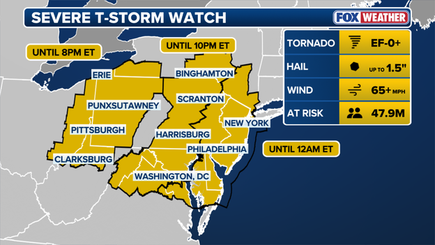
Severe Thunderstorm Watch till 12 a.m.
The watch covers millions of residents along the heavily traveled Interstate 95 corridor, including parts of the Washington, Baltimore, Philadelphia and New York City metropolitan areas.
The FOX Forecast Center warns that the strongest storms will be capable of producing damaging wind gusts, frequent lightning, torrential downpours and isolated hail as they move east through the evening hours.
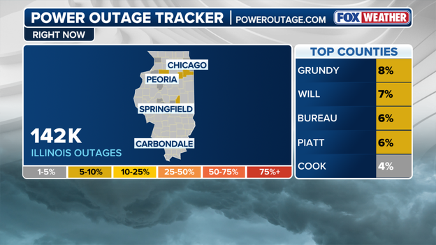
More than 135,000 customers across Illinois are without power Thursday evening as a dangerous multiday severe weather outbreak continues to hammer the Midwest.
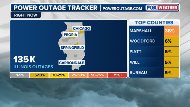
Illinois Power Outages
According to PowerOutage.us, more than 97,000 outages have been reported in Cook County alone, where Chicago and many of its suburbs have been impacted by destructive thunderstorms, damaging winds and tornado-producing storms.
In central Illinois, Marshall County, where a Tornado Emergency was issued earlier, has seen widespread impacts with nearly 40% of customers without power.
A Tornado Watch remains in effect for much of northern Illinois, including Cook County and the Chicago metropolitan area, as a powerful line of storms races eastward.
The threat isn't over, so stick with FOX Weather as we continue to track severe weather throughout the region.
A Tornado Emergency has been issued for Marshall County as a dangerous tornado.
The Emergency has been issued for the communities of La Rose, Toluca and Wenona, and includes Interstate 39, between Mile Markers 29 and 40.
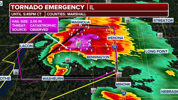
Tornado Emergency
The large, destructive tornado was confirmed near Washburn, Illinois, about 8 miles southeast of Lacon, as it tracked northeast at 40 mph.
The storm poses a catastrophic threat, bringing massive hail and life-threatening conditions.
A confirmed tornado has been reported in Marshall and Woodford counties in north-central Illinois.
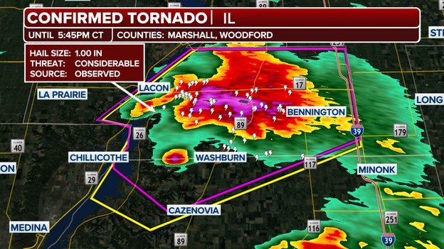
Confirmed Tornado
The tornado was deemed particularly dangerous, prompting the National Weather Service to issue a Particularly Dangerous Situation (PDS) alert.
Severe storm watches span hundreds of miles across the Midwest.
Severe storm watches - including tornado and thunderstorm watches - currently span 900 miles as severe storms are expected to continue.
The 900-mile stretch goes from Wisconsin to Texas, and the watches will remain in effect through 9 p.m.
Areas could see strong wind gusts, hail and possible tornadoes, according to the FOX Forecast Center.
The number of residents in Illinois without power
More than 230,000 customers are without power across the U.S. as another around round of intense severe weather moves over the region.
According to PowerOutage.us, over 138,000 residents in Illinois are still without power, while in Pennsylvania, close to 45,000 customers are experiencing power outages.
These numbers are expected to rise though out the evening as severe weather continues.
This all started on Wednesday as powerful thunderstorms swept through the Midwest, bringing heavy rainfall and wind gusts up to 90 mph.
Numerous states reported significant damaging including down trees and power lines.
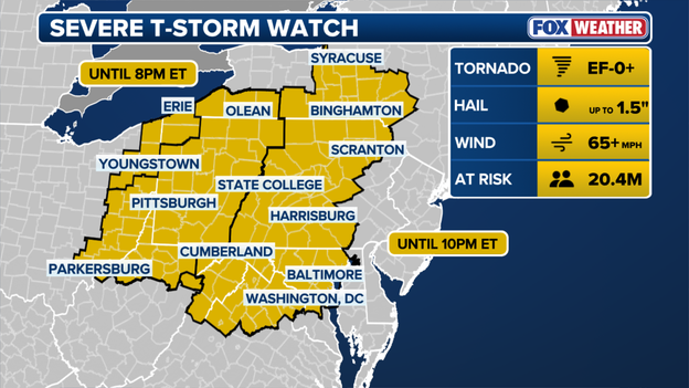
Severe thunderstorm watch expands east to include Washington, D.C. and Baltimore.
A Severe Thunderstorm Watch currently in effect for millions of Americans has expanded east to include portions of the interior Northeast tonight.
Washington, D.C. and Baltimore, Maryland, now fall in the threat zone for potential severe thunderstorms through 8 p.m. ET, according to the FOX Forecast Center.
EF-0+ tornadoes are possible with these storms, as well as strong wind gusts that could exceed 65 mph.
A total of 20.4 million Americans fall under this expanded watch, and hail up to 1.5 inches is also possible.
The FOX Forecast Center is monitoring severe storms that are expected to develop along the East Coast this afternoon.
Cities from Norfolk, Virginia, to Bridgeport, Connecticut, fall in the danger zone.
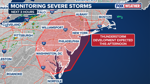
Thunderstorms to develop along the East Coast this afternoon.
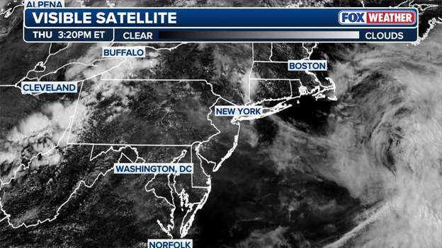
Satellite imagery shows storms moving toward the shoreline.
Satellite imagery shows clouds moving eastward toward the shoreline.
Record heat will help ignite scattered severe storms across the Northeast and Mid-Atlantic today ahead of a greater risk for severe weather on Friday.
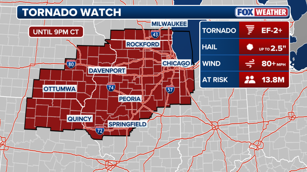
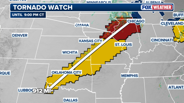
A Tornado Watch covering 13.8 million people has been issued in the Midwest through 9 p.m. CT.
A Tornado Watch has been issued for portions of five states in the Midwest, covering 13.8 million Americans, through 9 p.m. CT tonight.
Cities in Iowa, Illinois, Missouri, Wisconsin and Indiana are in the threat zone. This includes Chicago, Davenport, Springfield, Peoria and more.
Strong tornadoes (Ef-2+) and wind gusts over 80 mph are likely with these storms, according to the FOX Forecast Center.
Any hail that falls could be egg-sized, up to 2.5 inches.
The Storm Prediction Center (SPC) has just issued an update for the central United States, announcing an 80% probability that a Severe Thunderstorm or Tornado Watch will be officially issued shortly.
The risk zone stretches across southeastern Kansas, western Missouri, and northeastern Oklahoma.
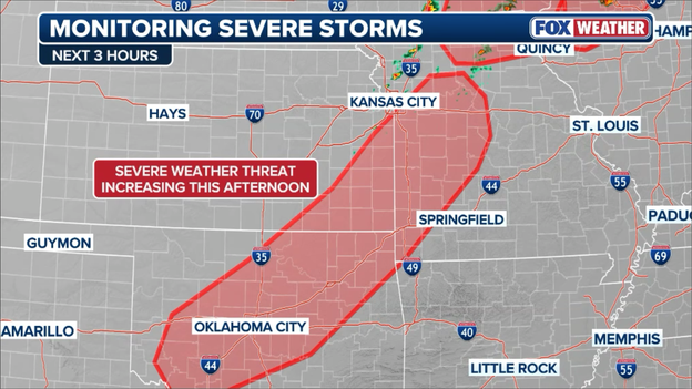
The Storm Prediction Center is monitoring the increasing threat for severe weather across the Plains this afternoon.
Forecasters warn that a rapidly destabilizing atmosphere will spark widespread thunderstorm coverage through the afternoon hours, with destructive wind gusts and large hail serving as the primary threats.
The focal point for today's dangerous setup is a cold front slicing through the region. Ahead of the front, temperatures have soared into the upper 80s and low 90s, completely erasing any capping in the atmosphere and creating massive amounts of energy to fuel explosive storm growth.
While storms are expected to quickly cluster together into a powerful line capable of widespread wind damage, a slightly more favorable wind profile in eastern Kansas and western Missouri could allow for individual, rotating supercell structures.
This means a localized tornado threat cannot be ruled out, particularly into the mid-to-late afternoon hours. Residents in these three states should closely monitor local radar and have multiple ways to receive warnings as these storms rapidly intensify.

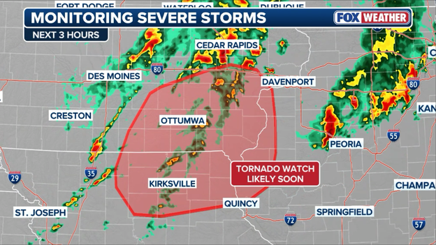
The Storm Prediction Center says it will issue a new Tornado Watch for portions of the Midwest shortly.
The Storm Prediction Center (SPC) has issued a critical update for the Midwest, announcing that a new Tornado Watch is highly likely in the next few hours.
The heads-up specifically covers northeast Missouri, southern and eastern Iowa, and far western Illinois.
Meteorologists monitoring the region note that the environment is rapidly destabilizing, making conditions highly favorable for the development of severe, rotating storms.
The primary culprit behind this growing threat is a rapidly moving cold front colliding with a retreating outflow boundary. Ahead of this front, a surge of tropical moisture has pushed dew points into the low 70s, providing plenty of fuel for storm development.
More concerning to forecasters is the presence of intense low-level wind shear. With strong deep-layer wind shear and favorable spin in the lower atmosphere, storms that fire up this afternoon are expected to quickly organize into dangerous supercells.
Residents within this three-state zone need to be on high alert. Because the atmosphere is so highly energized, these initial supercells will be capable of producing a few strong tornadoes.
Additionally, the extreme moisture in place means any storm clusters that merge will also bring a substantial risk for widespread damaging winds and blinding downpours.
If you live in northeast Missouri, southern or eastern Iowa, or western Illinois, now is the time to review your severe weather plan, ensure your smartphone alerts are turned on, and know exactly where to go if a warning is issued for your community.
Baseball fans at Kauffman Stadium have been left scratching their heads this afternoon when the Kansas City Royals announced a weather delay for their scheduled game against the Texas Rangers.
Despite the official "delayed" status, there were no storms in sight minutes before the first pitch time.
Social media quickly filled with frustrated posts and pictures of dry, cloudy skies, leaving fans asking why a rain delay was called before a single drop had fallen.
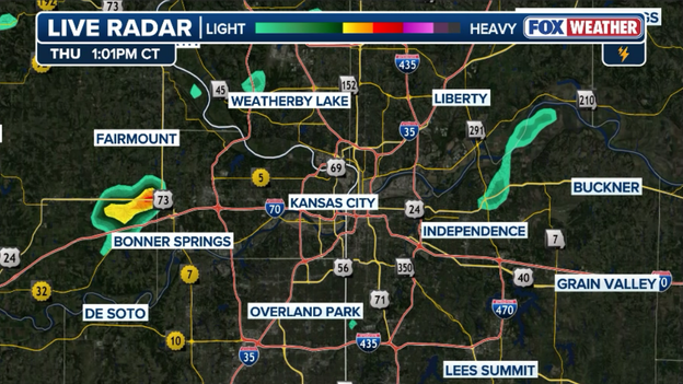
Radar showing one lone shower west of the Kansas City metro at 1:00 p.m. CT on Thursday.
While the pre-emptive pause was likely made out of an abundance of caution due to incoming storms forecast for later in the afternoon, it did little to soothe the confusion of those sitting in dry seats waiting for baseball to start.
The operational headache for air travelers is growing by the hour as a relentless barrage of nationwide thunderstorms continues to cripple the U.S. aviation network.
With multiple ground stops and traffic management programs already bottlenecking hubs in the Midwest and Northeast, the gridlock has officially expanded into the nation's capital.
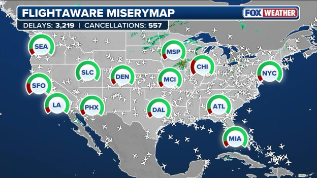
FlightAware MiseryMap showing where flight disruptions are causing headaches for travelers.
Ronald Reagan Washington National Airport (DCA) has just been placed under a ground delay program, leaving passengers facing average delays of nearly one hour as air traffic controllers struggle to space out arrivals around storms.
As these rolling delays stack up and gates become severely congested across the country, travelers should prepare for a very long afternoon of missed connections and frustrating tarmac waits.
Utility giant ConEdison recently shared a video on X highlighting the extensive, behind-the-scenes work that goes into safeguarding the power grid before severe weather even hits.
To prepare for the upcoming storm season, the company conducts rigorous practice drills that simulate real-life emergency scenarios, ensuring their teams remain ready for whatever extreme weather brings.
Staying ahead of severe weather has never been easier, as you can stream FOX Weather live 24/7 on virtually any device without needing a paid cable subscription.
For direct, on-the-go access, simply download the free FOX Weather app on your iOS or Android smartphone or tablet to unlock live video streams, customized alerts, and interactive 3D radar.
If you prefer watching on the big screen at home, you can easily find the FOX Weather app or channel on major connected TV and streaming platforms—including Roku, Amazon Fire TV, Apple TV, YouTube TV, and Pluto TV.
Click here to see how to watch FOX Weather on your favorite streaming device.
Whether you are tracking major storm outbreaks from your living room or checking localized updates on your phone, America's Weather Team is always just a quick tap away.
An ominous, towering shelf cloud put on a dramatic display over Stone Harbor, New Jersey, Wednesday night as a volatile line of thunderstorms swept through the coastal community.
The striking scene was captured on video by Zeke Orzech via Storyful, showcasing the leading edge of the storm as it advanced over the region.
The atmospheric unrest is far from over, as forecasters warn that more thunderstorms are expected to target the Northeast both today and tomorrow, keeping the threat of severe weather alive through the end of the week.
FOX Weather viewer Chelsea Nizzi captured the raw intensity of today's severe weather firsthand, documenting the powerful storms as they rolled right through her neighborhood. Her video shows an incredible amount of large hail stones falling with such volume that they completely blanketed the deck of her home in a thick layer of ice.
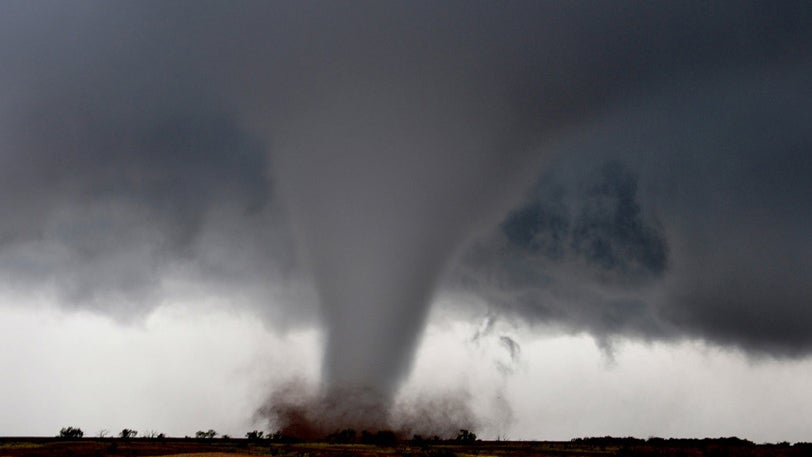
When a devastating tornado strikes a community, you often hear meteorologists assign it an "EF" rating on a scale from 0 to 5. This system is known as the Enhanced Fujita Scale (EF Scale), and contrary to what many believe, it is not a measure of a tornado's physical size or real-time radar appearance.
Instead, the EF Scale is a damage-based ranking system used by teams of expert meteorologists and engineers to estimate a tornado's peak wind speeds after the storm has passed.
Because we cannot safely place traditional wind sensors directly in the path of a violent vortex, scientists use the surrounding destruction as a proxy for wind velocity.
To do this systematically, the EF Scale utilizes 28 distinct Damage Indicators.
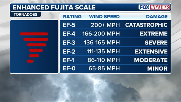
The Enhanced Fujita Scale is used to rate the strength of tornadoes based on the damage they produce.
These indicators represent a wide variety of structures and objects, including single-family frame houses, commercial office buildings, mobile homes, schools, trees, and even free-standing towers.
When conducting a post-storm survey, meteorologists analyze these structures and look for specific Degrees of Damage—ranging from minor shingle loss on a roof to a building being completely swept off its foundation.
This meticulous process ensures that the historical record of severe storms remains accurate, helping engineers improve modern building codes and allowing meteorologists to better understand the true power of these violent atmospheric phenomena.
The system is named after Dr. Tetto "Ted" Fujita, a legendary University of Chicago meteorologist whose pioneering research in the 1970s created the original Fujita Scale (F-Scale) to categorize tornadoes by their destruction.
In 2007, weather officials and engineers formally updated his groundbreaking system to more accurately reflect how modern building materials withstand extreme winds, giving birth to the Enhanced Fujita Scale (EF Scale) we use today.
The name beautifully preserves Dr. Fujita's monumental legacy while signaling that the underlying science and engineering metrics have been significantly upgraded for the modern era.
The Federal Aviation Administration (FAA) has issued a temporary ground stop for Chicago O'Hare International Airport (ORD) as severe weather continues to impact transit corridors.
The traffic pause is scheduled to remain in effect until 2:15 p.m. ET to ensure safety as regional storms move through the area.
The FAA has ordered a ground stop for Chicago O'Hare International Airport until 2:15 p.m. ET.
This particular restriction is highly selective, only impacting scheduled departures heading to O'Hare from certain specific airports within the Midwest.
While the broader national airspace continues to flow, travelers originating from the impacted regional hubs should check their flight status directly with their carriers for potential rolling delays.
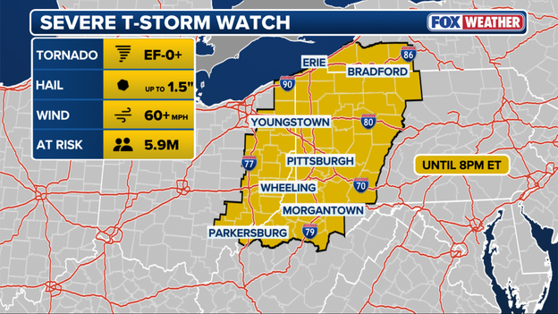
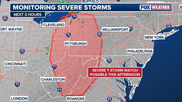
The Storm Prediction Center has issued a Severe Thunderstorm Watch for portions of western New York, western Pennsylvania, eastern Ohio, and northern West Virginia until 8 p.m. ET.
The threat of severe weather is escalating as the Storm Prediction Center issues a Severe Thunderstorm Watch for portions of western New York, western Pennsylvania, eastern Ohio, and northern West Virginia.
The watch is scheduled to remain in effect until 8:00 p.m. ET and encompasses several major population centers, including Pittsburgh and Erie, Pennsylvania.
Residents across these areas should prepare for rapidly developing storms capable of producing damaging wind gusts and localized hail as a volatile air mass recharges this afternoon.
With active alerts stretching across the region, it is crucial to understand the difference between a watch and a warning so you can take the appropriate level of action:
Severe Thunderstorm Watch: This means severe weather is possible in and close to the watch area. Think of it as having all the right ingredients to bake a cake—the moisture, heat, and wind shear are all present in the atmosphere, but the storms haven't fully formed yet. During a watch, you should review your safety plans, keep your devices charged, and closely monitor local radar.
Severe Thunderstorm Warning: This means severe weather has actually been sighted or indicated by weather radar. In the cake analogy, the cake is now baked and out of the oven. A warning means there is an imminent danger to life and property, and you need to take shelter immediately in a sturdy building or interior room.
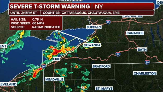
The National Weather Service has issued a Severe Thunderstorm Warning for Cattaraugus, Chautauqua, and Erie Counties in New York until 2:15 p.m. ET.
The active afternoon is officially underway in the Northeast as the National Weather Service has issued the first Severe Thunderstorm Warning of the day for the region.
The warning is tightly focused across western New York, encompassing communities located south of the Buffalo metro area. Forecasters say this initial cell is packing a punch, with the potential to unleash destructive wind gusts up to 60 mph and heavy downpours.
The threat is tracking steadily through the area, and the warning remains in active effect until 2:15 p.m. ET, serving as a clear signal that the region's highly charged atmosphere is beginning to fire up.
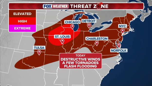
What is the FOX Weather Threat Zone?
When severe weather breaks out across the country, keeping track of overlapping government watches, warnings, and localized risk levels can get confusing. That is where the exclusive FOX Weather Threat Zone comes in.
Developed by the FOX Forecast Center, the Threat Zone is a clear, visual forecasting tool designed to cut through the noise and show you exactly where severe weather—capable of producing tornadoes, giant hail, and destructive straight-line winds—as well as dangerous flash flooding, are most likely to hit through the day and into the overnight hours.
By highlighting the areas at maximum risk, it gives families and travelers an easily digestible, heads-up look at where the atmosphere is primed to turn violent.
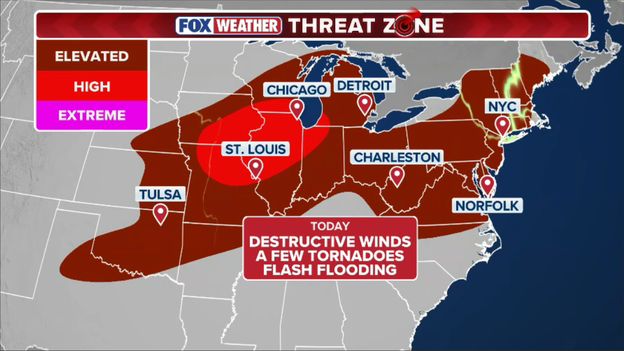
The FOX Weather Threat Zone shows where destructive winds, intense tornadoes, large hail, and flash flooding could impact Americans through tonight.
A 2,000-mile danger zone puts 154 million Americans at risk today
Today, that Threat Zone is highlighting an incredibly expansive and dangerous setup. A powerful upper-level weather system is dragging a cold front through a highly energized, hot, and humid air mass, creating a massive storm corridor that stretches thousands of miles from the Central Plains all the way into the Northeast and Mid-Atlantic.
This sprawling system places a staggering 154 million Americans in the crosshairs of severe weather and flash flooding today.
The atmosphere along this entire track is highly volatile, but it is presenting two distinct flavors of trouble depending on where you live:
- The Plains and Midwest: Communities stretching from Nebraska and Kansas through the Mississippi Valley are facing a renewed severe storm threat. This is particularly dangerous for parts of the Midwest that were slammed by yesterday's violent, 90-plus mph derecho. With hundreds of thousands still in the dark, any new storms tracking over the region today bring a distinct threat of strong tornadoes and large hail that could severely hamper ongoing power restoration efforts.
- The Northeast and Mid-Atlantic : Farther east, intense daytime heating and deep moisture are rapidly destabilizing the air along the densely populated I-95 corridor, stretching through major metro hubs like New York and Washington. Storms firing in this sector are expected to tap into tropical moisture, creating an environment primed for widespread damaging wind gusts and heavy rain rates that could trigger sudden, dangerous flash flooding in urban areas.
With major metropolitan areas under the gun, everyone living within today's Threat Zone is urged to keep their FOX Weather app open, secure any outdoor items, and have a plan to take immediate shelter if warnings are issued for your community.
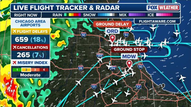
The FAA has ordered a ground stop for Chicago's Midway International Airport for flights arriving from certain airports in the Midwest.
The Federal Aviation Administration (FAA) has issued a temporary ground stop for Chicago Midway International Airport (MDW) as strong storms push through the region.
The traffic pause is scheduled to remain in effect until 2:15 p.m. ET to help manage safety and airspace congestion.
This specific restriction is highly targeted, only affecting scheduled departures bound for Midway from certain select airports across the Midwest.
Travelers within the region are encouraged to check their flight status directly with their airline, as these localized ground stops can trigger short-term delays and scheduling adjustments.
The intense heat and humidity blanketing the Northeast and Mid-Atlantic aren't just making it uncomfortable to step outside—they are setting the stage for a dangerous flash flooding threat.
Any thunderstorms that ignite this afternoon and through the weekend will be tapping into an extraordinarily deep pool of tropical moisture. Because the atmosphere is so heavily saturated, these storms will behave like atmospheric sponges, capable of unleashing torrential downpours that could dump a quick 3 to 6 inches of rain in a very short amount of time.
When that much water falls so rapidly, the ground simply cannot absorb it. Urban areas, low-lying roads, and small creeks across the I-95 corridor will be particularly vulnerable to sudden and dangerous flash flooding.
Forecasters are urging residents from Virginia up through New England to closely monitor radar, avoid driving through water-covered roadways, and remain alert for rapidly issued flood warnings as these high-efficiency rainmakers move through.
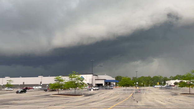
A line of strong thunderstorms is steadily marching toward the Chicago metro area from the west this afternoon, threatening to disrupt outdoor plans across the city.
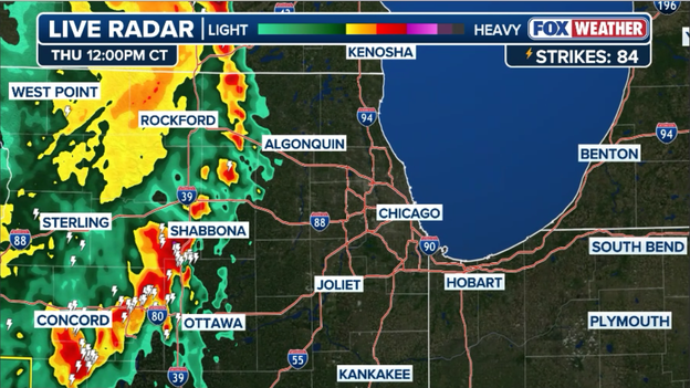
Radar showing strong thunderstorms approaching the Chicago metro area from the west.
Fortunately, these tracking storms are currently below severe limits and do not carry warnings. However, commuters and shoppers along the Magnificent Mile should still prepare for a sudden face-full of gusty winds and brief, blinding downpours as the leading edge of the system makes its way into the heart of downtown.
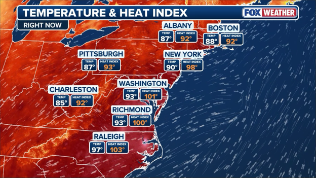
Temperatures are in the 80s and 90s across the Northeast and Mid-Atlantic with heat index values topping 100°F.
An intense wave of searing heat and high humidity is gripping the Northeast and Mid-Atlantic right now, driving heat index values dangerously high.
Actual air temperatures have already hit 90°F in New York and 93°F in Washington, with the stifling humidity creating "feels-like" heat index values of 98°F and 101°F respectively.
The tropical moisture is acting as premium atmospheric fuel, setting the stage for a volatile afternoon and evening as a cold front collides with the sweltering air mass to trigger severe thunderstorms capable of producing damaging winds, frequent lightning, and localized flash flooding across the region.
The explosive severe weather tracking across the central and eastern United States has triggered a major slowdown at New York City's primary aviation hubs.
The Federal Aviation Administration (FAA) has implemented a Ground Delay Program for both John F. Kennedy International Airport (JFK) and LaGuardia Airport (LGA) this afternoon.
Travelers are being hit with mounting disruptions, as arriving and departing flights at both airports are now experiencing average delays hovering around one hour.
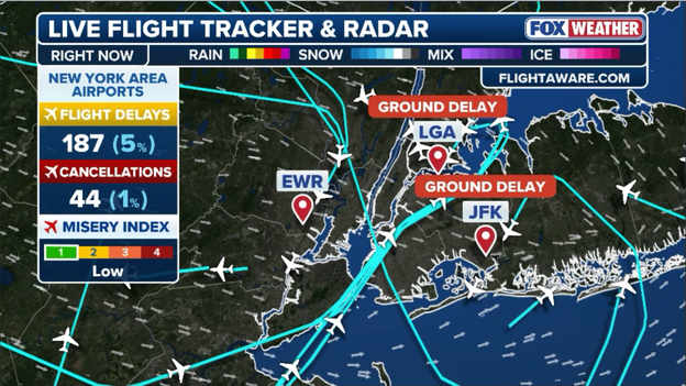
The FAA has issued ground delay programs for both John F. Kennedy International Airport (JFK) and LaGuardia Airport (LGA) this afternoon.
What makes today's travel headache unique is that the gridlock is not just being caused by local weather. The atmosphere across the eastern half of the country is highly volatile, with an intense multi-state storm outbreak tracking through the Midwest and severe, heat-fueled storms firing along the East Coast.
Because the FAA must reroute planes around giant walls of thunderstorms scattered across major national flight corridors, it creates a massive structural bottleneck. This regional "domino effect" means that even if the skies directly over Queens look clear, planes bound for NYC are being held at their originating gates nationwide to prevent overcrowding in the air.
Passengers scheduled to fly through the tri-state area today are strongly urged to check their flight status before heading out, as these hour-long delays can quickly stack up as the afternoon storms intensify.
The Storm Prediction Center is keeping a close eye on a dynamic weather situation unfolding across five states this afternoon.
Forecasters say they're considering a Severe Thunderstorm Watch for western Pennsylvania, eastern Ohio, western Maryland, north-central Virginia, and a large portion of West Virginia.
The Storm Prediction Center is monitoring the Northeast for severe weather in the hours ahead.
Driving this developing threat is a combination of a subtle atmospheric disturbance moving over Lake Erie and central Ohio, combined with intense daytime heating.
At the surface, a steady flow of warm, moist air from the southwest has pushed temperatures into the 80s and sent dew points into the sticky 70s. This influx of moisture is creating a highly unstable air mass with plenty of atmospheric fuel to go around.
While the overall steering winds higher up in the atmosphere are relatively modest for mid-June, they are still strong enough to keep storms organized.
Meteorologists tracking the regional data notice that the air is primed for downbursts—intense, downward-rushing columns of air that can slam into the ground and radiate outward as destructive straight-line winds.
Because the air is so heavy and humid, the threat for large hail is somewhat limited, but powerful storm cores could still drop localized ice.
Residents in the alert zone should keep a close eye on the sky this afternoon and have a reliable way to receive weather warnings as these scattered storms begin to fire up.
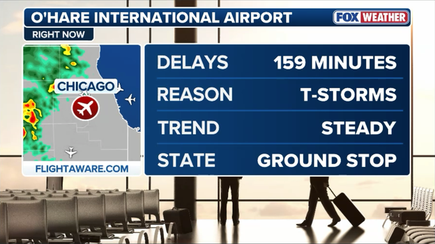
The Federal Aviation Administration (FAA) has implemented a significant ground delay program at Chicago O'Hare International Airport (ORD) as thunderstorms approach northeastern Illinois.
Travelers are facing an operational nightmare, with arriving and departing flights slammed by an average delay of 159 minutes—meaning passengers are sitting tight for nearly two hours and forty minutes past their scheduled times.
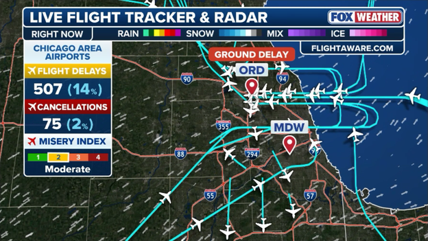
The FAA has implemented a ground delay program, meaning flights destined to Chicago's O'Hare International Airport, are being delayed by nearly three hours due to thunderstorms in the region.
Major carriers with hubs at O'Hare, including United Airlines and American Airlines, are bearing the brunt of the chaos, with hundreds of flights falling behind schedule.
Because O'Hare acts as a vital artery for the entire national airspace network, these hefty 159-minute delays are already causing a massive ripple effect, triggering connection issues and subsequent flight disruptions at airports from coast to coast.
FOX Weather meteorologists are using the phrase "high ceiling, low floor" to describe today's explosive severe weather threat in the Midwest, meaning the atmosphere is capable of two drastically different outcomes.
The "high ceiling" represents a worst-case scenario. If the morning cloud cover clears out quickly and individual, isolated supercell storms can form on their own, the background wind shear and tropical moisture are strong enough to yield a high-end outbreak, including violent, long-track tornadoes and baseball-sized hail.
Conversely, the "low floor" scenario means the event could underperform compared to the worst forecasts. If the thick clouds from this morning's rain linger too long, they will block the sun, keep temperatures cooler, and effectively starve the atmosphere of the unstable fuel it uses to build giant storms.
Additionally, if the storms immediately fire up all at once and cluster into a messy, solid line rather than staying separated, the extreme tornado threat would drop significantly, shifting the primary hazard to straight-line wind damage.
Because the line between a historic outbreak and a localized event is so incredibly thin today, forecasters are emphasizing that residents cannot afford to let their guard down.
While meteorologists often look at morning rain and cloud cover as a "wet blanket" that cools the atmosphere and diminishes storm energy, today's setup across Illinois features a hidden danger.
As the initial cluster of morning storms pushes eastward, it is leaving behind a distinct, west-to-east boundary of rain-cooled air cutting right across northern Illinois.
This boundary creates a localized zone of extreme contrast where warm, unstable air from the south collides with the cooler morning air mass, presenting a major point of concern for severe weather development this afternoon.
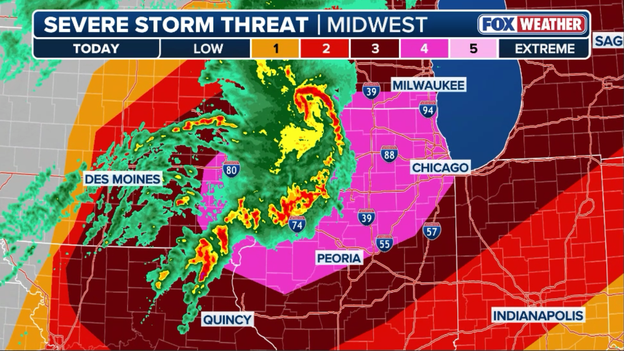
Radar shows where strong storms could create the perfect setup for tornadoes later this afternoon across the Midwest.
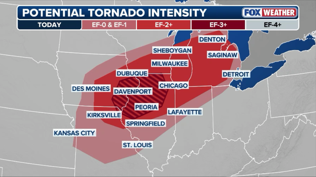
The Storm Prediction Center says EF-3 (or greater) tornadoes will be possible later today across Illinois.
This specific type of boundary acts as a powerful focal point for tornado development. If an isolated supercell thunderstorm manages to cross or track directly along this line, it can tap into a sudden, massive increase in low-level wind shear—the twisting of winds with height. The boundary essentially introduces highly concentrated spin near the ground.
Because the background atmosphere is already incredibly energetic, any strong storm that interacts with this line will have the ability to stretch and intensify that spin rapidly.
This creates a prime environment for producing intense, long-track tornadoes (rated EF-3 or higher), meaning residents in northern Illinois must remain highly vigilant even if their midday skies look deceptively calm.
The multi-day severe weather siege gripping the central U.S. is reaching a dangerous crescendo today, and meteorologists warn that this third consecutive day of storms could easily be the most violent yet.
Since the weekend, an active and relentless weather pattern has already unleashed nearly 1,000 reports of large hail, destructive straight-line winds, and tornadoes across the nation's midsection.
Wednesday alone marked one of the three most active severe weather days of the entire year, punctuated by a ferocious 350-mile derecho that packed hurricane-force gusts up to 94 mph and plunged over 400,000 homes and businesses into darkness.
Severe thunderstorms are forecast to blast across the Midwest this afternoon-evening.

Line of thunderstorms approaches Dwight, Illinois on Wednesday. (Travis Lanham)
Yet, despite the widespread damage already left in its wake, the atmospheric setup today is even more volatile, prompting the Storm Prediction Center to issue a level 4 out of 5 risk upgrade for parts of the Midwest.
What makes today's threat uniquely dangerous—and potentially worse than yesterday—is a transition in the storm structure and location.
While Wednesday was defined by a massive, fast-moving wall of straight-line winds, today’s environment is primed to strong tornadoes and widespread destructive winds.
Today, supercells, isolated, intensely rotating thunderstorms, will have a continuous tap of highly energized, tropical air and unusually strong upper-level winds.
As a result, the atmosphere is capable of producing baseball-sized hail, localized wind gusts over 75 mph, and a few long-track, intense tornadoes.
Today's storms will also target major population centers in the Midwest: Chicago, Milwaukee, St. Louis, and Detroit.
And because these storms will be tracking directly over saturated ground and vulnerable power grids that were compromised less than 24 hours ago, the potential for flash flooding and catastrophic infrastructure damage is exponentially higher, cementing today as the ultimate wildcard of this historic outbreak.
Radar showing a cluster of strong and severe thunderstorms charging east across the Midwest at this hour.
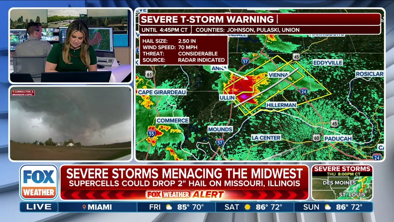
A dangerous, fast-moving cluster of severe thunderstorms is aggressively charging eastward across Missouri, Illinois, Iowa, and Wisconsin this hour.
Fueled by intense atmospheric energy and tracking ahead of an advancing frontal boundary, these potent storms are unleashing a multi-state onslaught of damaging winds, heavy downpours, and localized rotating elements that are keeping millions of residents on high alert.
New York City officials are advising residents to stay weather aware as a volatile combination of extreme heat and severe weather targets the region.
According to a post shared by New York City Emergency Management, the city is tracking an expansive severe weather threat that is expected to trigger storms capable of producing localized heavy downpours, lightning, and strong wind gusts.
The dangerous setup is being supercharged by an oppressive regional heat wave, which has prompted widespread Heat Advisories across the metropolitan area.
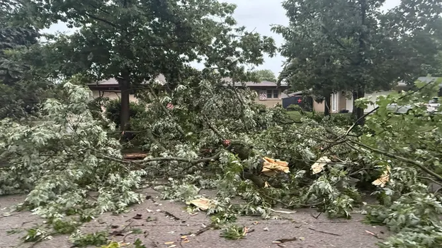
The violent morning storms sweeping through Iowa have turned tragic in Polk County. The Polk County Emergency Management Agency has confirmed a storm-related fatality in the Prospect Park neighborhood of Des Moines, where a man tragically died after a tree fell on him during the height of the severe weather.
The Des Moines Police Department and the Polk County Medical Examiner's Office are actively investigating the incident. The tragedy underscores the extreme danger posed by today's severe weather outbreak, which has repeatedly hammered the region with destructive winds capable of uprooting trees and shredding structures.
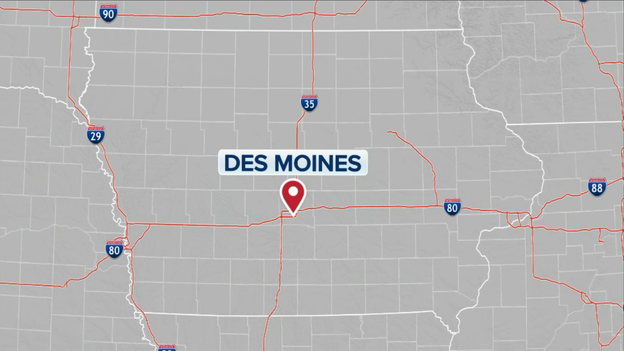
The Polk County Emergency Management Agency has confirmed a storm-related fatality in the Prospect Park neighborhood of Des Moines.
Beyond the deadly incident, emergency officials are managing widespread infrastructure disruptions and extensive property damage across the area.
Power outages peaked at roughly 7,000 customers in the Des Moines metro area earlier this morning, with MidAmerican Energy crews actively working on repairs to restore service.
The Polk County Emergency Management Agency also received reports of severe weather warning siren malfunctions in Polk City; all documented failures have been passed along to city officials for immediate action.
Meanwhile, emergency responders are dealing with countless reports of downed trees, snapped branches, and significant windborne debris—including large trampolines that were lifted and tossed across neighborhoods by the fierce winds.
New York City is feeling a lot more like South Florida this morning as a wave of intense heat and tropical moisture sweeps into the Northeast.
In a striking regional comparison, the FOX Forecast Center says Manhattan is tracking just as muggy as Miami, with both cities registering a soupy dew point of 72°F.
While New York's actual air temperature sits at 83°F, the moisture has pushed the local feels-like temperature to 88°F.
Down in Miami, the temperature stands at 86°F with a heat index making it feel like a sweltering 92°F, proving that the Big Apple is giving the subtropics a serious run for its money today.
Wednesday's relentless severe weather outbreak left a path of extensive destruction across Wisconsin, keeping emergency crews and disaster relief volunteers working around the clock.
In Sheboygan, the storms turned dangerous when a lightning strike ignited a fire at a home near 9th and Georgia Avenue, according to the fire department.
Meanwhile, the American Red Cross has stepped in to assist displaced families in Horicon, where the severe weather caused substantial structural damage.
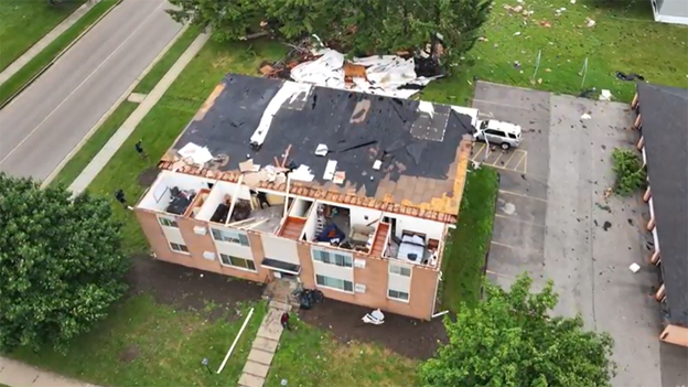
Severe storms ripped the roof off of Mary Lane Apartments in Lomira, Wisconsin on Wednesday, (FOX6 SKYFOX)
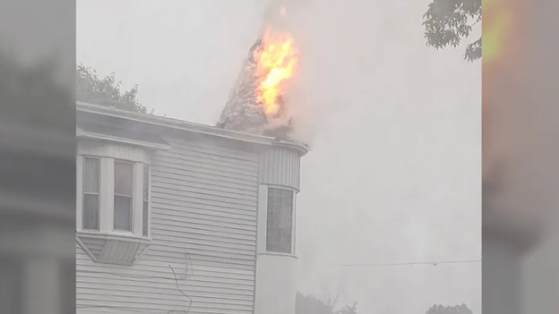
Fire near 9th and Georgia in Sheboygan, Wisconsin. (Carrie Bitters)
FOX6 News viewer Kelly O. shared dramatic video from Horicon that appears to show a roof completely blowing away after it was ripped off a building during the height of the storm.
Further south, the Village of Lomira was also heavily battered by the system. While officials initially suspected a tornado had touched down, the Village of Lomira later clarified that "significant wind" was the culprit behind the severe damage, which was primarily concentrated in the north and northeast portions of the village.
The straight-line winds were powerful enough to rip the entire roof off the Mary Lane Apartments, a scene captured by FOX6 SKYFOX.
Emergency responders in Lomira reported that while power was knocked out for many residents, thankfully no injuries have been reported.
To support the community during the recovery, a reception center has been opened in the village's community room, providing a safe space for affected residents to rest, charge electronic devices, gather information, and meet directly with emergency responders.
An intense wave of extreme heat and high humidity is gripping the East Coast and Northeast, sending afternoon temperatures soaring into the mid-90s.
Heat Advisories have been widely issued across the region, including New York and Philadelphia, as heat index values climb past 100 degrees, creating a highly energized and volatile atmosphere.
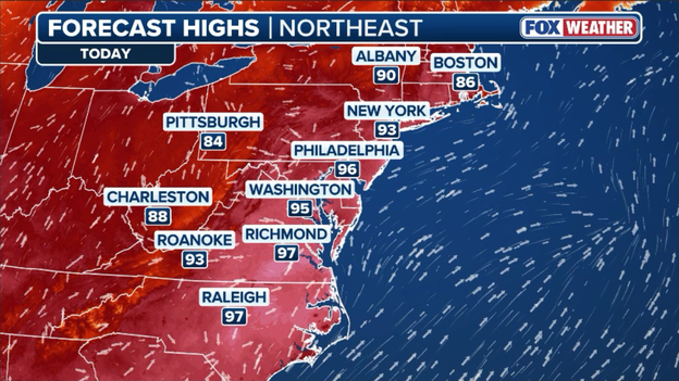
Forecast high temperatures for Thursday across the Northeast and Mid-Atlantic.
The FOX Forecast Center warns that this extreme heat will act as premium fuel for severe weather today and tomorrow, threatening the densely populated I-95 corridor with scattered severe thunderstorms capable of unleashing damaging wind gusts, frequent lightning, and large hail.
The sheer scale of Wednesday's destructive severe weather outbreak is now officially reflected in the record books. According to data from the FOX Forecast Center, June 10 ranked as the third-busiest day for severe storms so far this year in terms of the total number of official storm reports.
Fueled by the massive 350-mile derecho that ripped through five states, a staggering 410 storm reports of tornadoes, high winds, and large hail were logged across the central United States, cementing the day as one of the most widespread and impactful convective events of the season.
Hundreds of severe weather reports were sent into the National Weather Service on Wednesday.
A closer look at the data shows that June 10 only trails two highly prolific spring outbreaks: March 15, which still holds the top spot for the year with 620 reports, and April 17, which occupies the second spot with 529 reports.
Wednesday's historic derecho comfortably surpassed other notorious storm days from earlier in the spring, including April 27 (392 reports) and May 18 (366 reports).
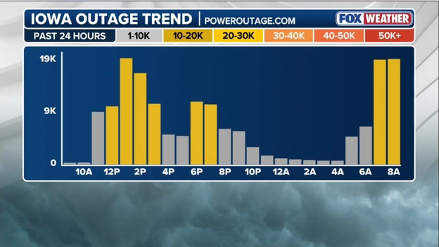
Latest power outage tracker showing another spike in outages this morning. (PowerOutage.com)
Power outages are soaring across Iowa once again this morning as a dangerous new wave of severe thunderstorms batters the region just hours after Wednesday's destructive derecho.
The fresh onslaught of hurricane-force wind gusts and tornadoes has heavily targeted the southwestern corner of the state, placing a secondary, crushing blow on an already vulnerable power grid.
Utility crews who had been working through the night to restore services are now facing a brand new wave of blackouts, with counties like Mills County reporting that over half of its residents have been thrust right back into darkness.
A dangerous complex of early morning severe thunderstorms dropped significant hail across parts of Iowa on Thursday, adding to the state's mounting storm damage.
FOX Weather viewer Chelsea Nizzi captured the intense weather firsthand, sending in images of large hail stones completely blanketing the deck of her home as the storms moved through.
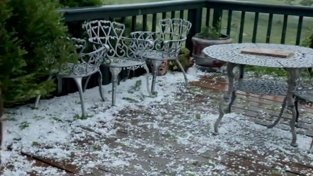
Hail covers a deck of a home in Van Wert, Iowa. (Chelsea Nizzi)
These freezing, fast-falling stones were part of a volatile morning system that also unleashed intense straight-line winds and triggered widespread power outages across the region.
A striking and ominous shelf cloud was spotted looming over Michigan on Wednesday evening, signaling the arrival of a violent line of severe storms.
FOX Weather viewer Izzy Swanson captured the eerie image from Mount Pleasant, Michigan, around 8 p.m. CT as the derecho began racing into the state.
Shelf cloud invades Mount Pleasant, Michigan on Wednesday evening. (Izzy Swanson)
These low-hanging, well-defined cloud formations typically serve as a dramatic visual warning, marking the leading edge of a storm's powerful and potentially destructive downdraft winds.
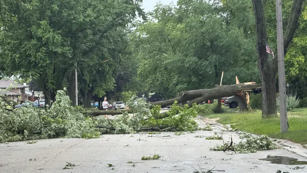
Numerous reports of storm damage and downed trees in Iowa are coming into the FOX Forecast Center this morning.
The FOX Forecast Center is tracking an onslaught of storm damage reports as severe thunderstorms continue to pummel waterlogged Iowa communities this morning.
Relentless straight-line winds and rotating storms have left a widespread trail of destruction, resulting in hundreds of reports of mature trees being completely uprooted or snapped.
Falling trees have blocked major roadways, smashed into structures, and tangled with utility lines, creating hazardous driving conditions and significantly complicating recovery efforts for local emergency crews.
Intense daytime heating will quickly recharge the atmosphere, causing a brand new, vicious round of severe storms to ignite by this afternoon.
This dangerous wave is expected to peak during the late afternoon and evening hours as it tracks eastward toward Lake Michigan, pushing severe hazards and tornado threats into parts of Illinois, Indiana, and Lower Michigan well into the night.
Computer forecast models show a line of destructive storms slamming the Midwest this afternoon.
If you look outside today, you might notice the air feels incredibly heavy and humid—and that is just the first ingredient in what is turning into a historic weather day.
The Storm Prediction Center has upgraded parts of the Midwest to a Level 4 out of 5 risk because the atmosphere is essentially acting like a powder keg.
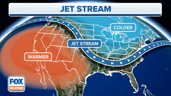
Driving this outbreak is a combination of rare, high-powered ingredients. A strong river of wind high up in the atmosphere, known as a jet streak, is moving directly over the Corn Belt. This is unusually powerful for mid-June, and it is acting like a giant engine, pulling air upward and giving these storms incredible strength and organization.

Intense upper-level winds from the jet stream will help fuel today's severe weather outbreak in the Midwest.
At the same time, a high-speed "moisture highway" of warm, unstable air is rushing up from the Gulf of America, fueling a massive cluster of storms that has been barreling east from Nebraska and Iowa since the overnight hours.
This cluster is being guided by its own localized spinning weather system, which is keeping the storms highly organized. Because these winds are rotating and strengthening as you go higher up in the sky, we are looking at a dangerous multi-hazard afternoon.
While widespread, destructive straight-line winds are the main threat, the atmosphere is so twisted that any individual storm that breaks away from the main line could easily start spinning and produce strong, long-track tornadoes.
The big wildcard that meteorologists are watching right now is the leftover clouds and rain-cooled air from this morning's storms. Think of morning storms like a wet blanket; they can temporarily cool the ground and rob the atmosphere of the afternoon sun it needs to fuel new storms.
However, today’s upper-level winds are so powerful that they will likely overcome that cooling effect. As a cold front pushes into the region later this afternoon and evening, the atmosphere will rapidly recharge.
This will spark a brand new, vicious round of storms that will track toward Lake Michigan, Illinois, Indiana, and Lower Michigan, keeping the severe weather and tornado threats alive well into the night.
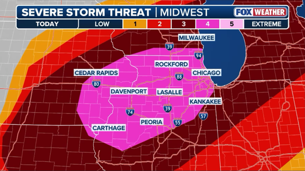
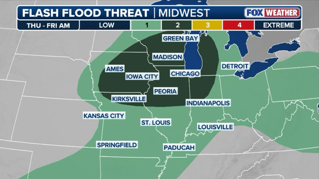
The Storm Prediction Center has officially upgraded the severe weather threat to a rare Level 4 out of 5 Moderate Risk for parts of northern Illinois and eastern Iowa.
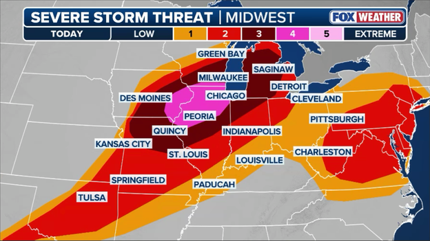
The Storm Prediction Center has issued a rare level 4 of 5 severe weather threat for portions of the Midwest on Thursday.
Forecasters raised the alarm after the latest atmospheric data revealed a highly volatile and dangerous environment primed for explosive storm development later today.
This significant escalation places high-population corridors on maximum alert, with the FOX Forecast Center warning that atmospheric ingredients are perfectly aligned to support multiple intense, long-track EF-3 or stronger tornadoes.
In addition to the heightened tornado threat, the upgraded zone faces a severe risk of destructive straight-line winds and giant hail.
This upgraded threat is materializing just hours after a powerful derecho knocked out power to hundreds of thousands in the same region, meaning today's storms will be striking vulnerable infrastructure and waterlogged communities.
Emergency officials are emphasizing that a Level 4 risk is not a typical severe weather day; residents in the risk zone need to treat this situation with the utmost urgency, review their severe weather plans immediately, and have multiple ways to receive life-saving warnings as the afternoon progresses.
Timelapse video shows a severe storm moving into Chicago bringing heavy rain, gusty winds and thunderstorms.
Increased damaging wind threats loom for millions across the Northeast as record heat and humidity build, fueling a multiday severe weather risk. Scattered storms are expected to ignite this afternoon, with an even greater risk of severe storm hazards Friday.
Stunning morning satellite imagery from NOAA's GOES-East (GOES-19) is tracking a highly volatile weather setup stretching across the central and eastern United States.
The FOX Forecast Center is tracking a mounting number of storm damage reports as severe thunderstorms continue to tear through Iowa this morning. Destructive winds have left a trail of widespread destruction, with numerous reports coming in of mature trees down, structural damage, and blocked roadways across the hardest-hit counties.
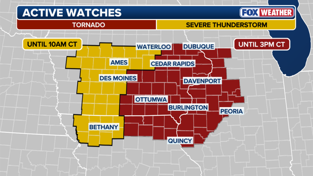
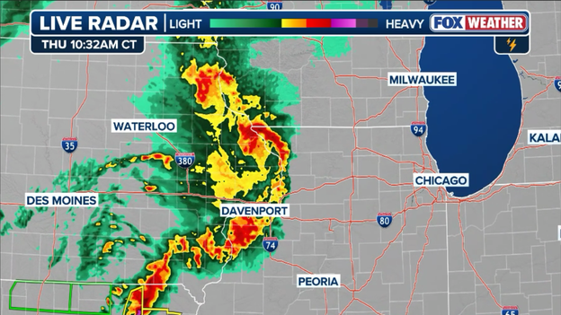
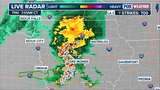
The Storm Prediction Center has issued a new Tornado Watch for parts of Iowa, Illinois, and Missouri until 3 p.m. CT.
The volatile weather setup across the nation's midsection has prompted a newly issued Tornado Watch for parts of eastern Iowa, western and central Illinois, and northeast Missouri.
The watch, issued Thursday morning by the Storm Prediction Center, remains in effect until 3 p.m. CT.
Meteorologists warn that a rapidly destabilizing environment ahead of an advancing cold front is creating prime conditions for discrete supercells and broken line segments capable of spawning tornadoes, scattered large hail, and destructive straight-line wind gusts.
Residents in the watch area—including major corridors near Peoria and the Quad Cities—are urged to have multiple ways to receive warnings and to know their severe weather safety plans as storms rapidly intensify midday.

Latest power outage tracker showing significant outages in southwest Iowa this morning. (PowerOutage.com)
A dangerous cluster of severe thunderstorms tracking through southwest Iowa this morning has caused power outages to rapidly spike across the region.
Following yesterday's destructive regional derecho, these fresh morning storms have brought another round of intense wind gusts and heavy rain to saturated communities, putting severe strain on local utility infrastructure.
According to PowerOutage.com, statewide outages have climbed to nearly 10,000 customers, with the vast majority of the damage concentrated heavily in the southwestern corner of the state.
The tracking data reveals that Mills County has been hit the hardest so far, with a staggering 51% of the county currently left without electricity. Neighboring communities are also experiencing significant disruptions, including Cass County at a 25% outage rate, Adams County at 18%, Fremont County at 11%, and Taylor County at 8%.
The severe weather threat broadens significantly today as a powerful upper-level trough pivots eastward, dragging a cold front into a highly energized environment stretching over 600 miles from eastern Missouri to northern Michigan.
The FOX Forecast Center says the Threat Zone for severe weather encompasses major metropolitan hubs like Chicago, Milwaukee, New York, and Washington, and places more than 150 million Americans in the danger zone.
Exclusive FOX Weather Threat Zone showing where severe weather and flash flooding are possible through tonight.
Intense daytime heating coupled with a continuous tap of moisture from the Gulf of America will rapidly destabilize the atmosphere. This setup is expected to ignite scattered to numerous severe thunderstorms by Thursday afternoon.
Forecasters note a potential wildcard: the exact timing and intensity of this afternoon's outbreak could heavily depend on how Wednesday night's storm complex evolves, as leftover morning cloud cover or rain-cooled air could delay or alter the peak threat.
Because today's storm mode will likely feature a dangerous mix of broken line segments and embedded supercells, residents must remain vigilant for all severe hazards.
Widespread damaging wind gusts exceeding 70 mph represent the primary threat, but large hail and tornadoes remain a distinct danger, particularly within any persistent supercells that manage to develop away from the main line.
Compounding the risk is a significant potential for flash flooding through tonight. These moisture-rich storms are forecast to produce widespread rain totals of 1 to 2 inches across Wisconsin, Iowa, and Illinois, with localized amounts topping 3 inches where storms stall or repeatedly track over the same areas.
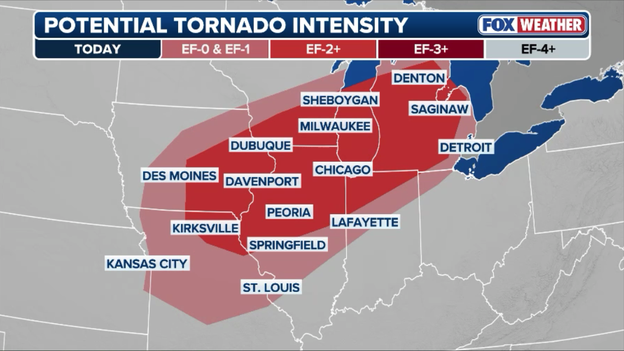
Forecasters say strong tornadoes (EF-2 or greater) will be possible across the Midwest through this evening.
Torrential rain could trigger flash flooding from the Great Lakes to the Central Plains through early Friday.
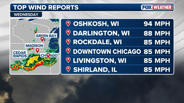
Top wind gusts recorded during Wednesday's severe weather outbreak in the Midwest.
The true, terrifying power of Wednesday evening's severe weather outbreak is coming to light as the FOX Forecast Center unpacks the staggering wind reports left behind by the historic derecho.
Packing straight-line winds equivalent to a Category 1 hurricane, the massive storm complex blasted through a 350-mile stretch from Iowa to Indiana.
To put the sheer intensity of this system into perspective, a storm is officially classified as a derecho when it produces a damage swath at least 250 miles long and 60 miles wide—a threshold this system easily shattered as it flattened trees, ripped apart structures, and obliterated regional power grids.
An examination of the top wind reports shows that Oshkosh, Wisconsin, bore the brunt of the storm's fury, clocking an incredible peak wind gust of 94 mph.
The destructive gusts were remarkably widespread across the region; Darlington, Wisconsin, was slammed by an 88 mph gust, while Livingston, Rockdale, and Shirland, Illinois, all recorded ferocious 85 mph winds.
Even the concrete jungle of downtown Chicago was not spared, matching the 85 mph mark as the bowing line of thunderstorms ripped directly through the metro area.
These prolonged, violent winds are the primary culprit behind the massive blackouts that initially left over half a million customers in the dark.
Video captured by FOX Weather exclusive storm tracker Brandon Copic shows the raw, terrifying power of the destructive derecho as it blasted through the Midwest on Wednesday.
Hundreds of thousands of Americans are waking up in the dark this Thursday morning after a violent, 350-mile derecho tore across the nation's midsection on Wednesday night.
The hurricane-force straight-line winds and scattered tornadoes completely shredded regional power grids, leaving widespread destruction in their wake.
According to data from PowerOutage.com, there are currently more than 416,000 total U.S. outages, with the vast majority concentrated in the storm-weary states of the Midwest.
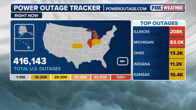
Latest power outage tracker showing significant outages across the Midwest following Wednesday's destructive storms. (PowerOutage.com)
Utility crews have been working through the night, but the sheer volume of downed trees, snapped utility poles, and tangled wires means restoration efforts will be a multi-day process for the hardest-hit communities.
Illinois remains the epicenter of the blackouts, with a staggering 208,000 customers currently lacking electricity. Michigan is also facing a massive recovery effort with 83.0k reported outages, while Ohio (13.2K), Indiana (11.2K), and Kansas (10.4K) round out the top five most severely impacted states.
Compounding the misery for residents without air conditioning or refrigeration, a secondary round of vicious storms is already targeting many of these same exact areas today. This renewed threat could not only hamper ongoing restoration efforts but potentially trigger a fresh wave of dangerous utility disruptions.
Radar showing severe storms slamming Iowa this morning with destructive winds, tornadoes, and torrential rain.
The storm-weary Midwest is getting no relief this morning as a dangerous complex of severe thunderstorms is tearing through Iowa.
Following yesterday's destructive 350-mile derecho, the Storm Prediction Center has placed southern, central, and eastern portions of the Hawkeye State under the gun for a multi-round severe weather threat today.
The morning's initial wave has prompted multiple Tornado Warnings and Severe Thunderstorm Warnings across southwest Iowa, with meteorologists warning of a volatile environment capable of producing localized tornadoes, large hail, and destructive straight-line winds tracking up to 80 mph.
Compounding the wind and tornado threats, torrential rain rates have triggered Flood Watches across a state where the soil is already saturated from Wednesday's system.
A destructive severe weather outbreak hammered the central U.S. on Wednesday evening, officially confirmed by the FOX Forecast Center as a powerful derecho.
This massive, long-lived windstorm carved a path of destruction stretching over 350 miles, igniting in Iowa before blasting through Illinois, Wisconsin, Michigan, and Indiana with hurricane-force gusts. The storm meets the official criteria for a derecho, which requires a swath of damaging winds at least 250 miles long and 60 miles wide, punctuated by multiple extreme wind reports.

Peak wind gusts recorded across the Midwest on Wednesday
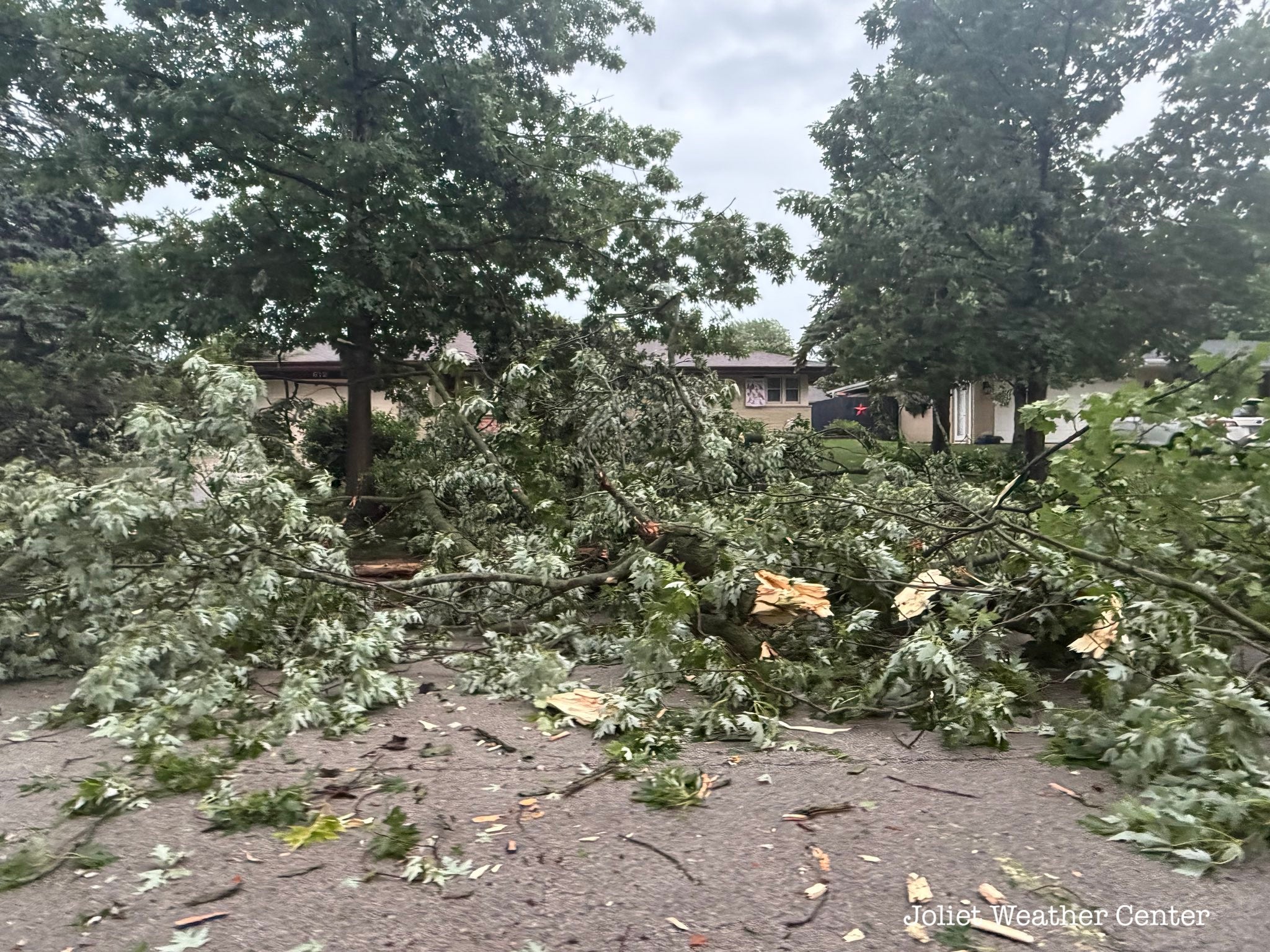
Countless trees down across the west side of Joliet, IL after severe weather impacted the city. (@JolietWeather/X)
Downed trees blocking roads in Joilet, IL. (@JolietWeather/X)

Trees down in Joilet, IL after severe thunderstorms. (@JolietWeather/X)
Peak gusts clocked in at an astonishing 94 mph in Oshkosh, Wisconsin, while both downtown Chicago and areas of northern Illinois were rocked by 85 mph winds.
Beyond the straight-line wind damage, the volatile system also spawned nearly a dozen confirmed tornadoes across Kansas, Missouri, and Iowa, with the heaviest concentration of twisters striking northern Missouri.
The violent storm system took a massive toll on the region’s infrastructure, leaving more than 500,000 customers without power across five states at the height of the storm. Illinois bore the brunt of the blackouts, with 300,000 homes and businesses thrust into darkness, followed closely by Michigan with 139,000 outages and Wisconsin with 100,000.
Sizable power failures were also tracked across Ohio and Indiana as trees and utility lines were shredded by the historic winds.
Utility crews are actively working to restore services today, but extensive grid damage means a long road to recovery for the hardest-hit communities.
You’ve reached the beginning of this live coverage.