Live updates: Tracking holiday weekend snow threat as El Niño signals grow for 2026
Live updates: Tracking holiday weekend snow threat as El Niño signals grow for 2026
Download the AppLIVE Severe Weather HQ coverage continues
View postCoverage for this event has ended.
FOX Weather is your Severe Weather HQ, providing around-the-clock live coverage this weekend.
For lucky couples across America, Valentine's Day will be yet another picturesque February day, other's can't be so sure. Let's have a look how the most romantic day of the year will look in some of the United States' most romantic towns and neighborhoods.
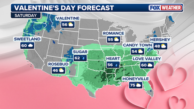
FOX Forecast Center's Valentine's Day Forecast in America's most romantic towns.
According to the FOX Forecast Center, it will be partly cloudy in Romance, Wisconsin, temperatures will over around 55 degrees, with forecasts lining up similarly in Valentine, Montana.
Hopefully the rain is the only waterworks happening in Heart, Arkansas, and Sugar, Colorado, where a strong storm will likely bring rain to soak any outdoor dates or activities planned.
Love will be in air in Honeyville, Florida, where beach picnics and sunset cruises are on the table a high of 75.
Love Valley, NC, Candy Town, OH, and Hershey, PA will all see similar conditions in the East.
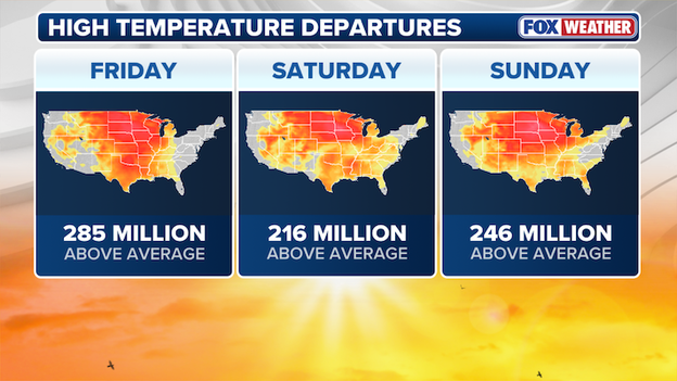
FOX Forecast Center is monitoring high temperature departures this weekend.
Into this weekend, over 200 million people will see warmer than average temperatures in the U.S. from Friday to Sunday.
The "Sunshine State" is rapidly becoming the "Dry State" as new data confirms Florida is battling its most severe drought conditions in over two decades. With 95% of the state now experiencing significant moisture deficits, the situation has escalated into a full-blown water crisis that is triggering emergency measures from the Panhandle to the Keys.
"Extreme" drought now covers nearly half of the state, including a massive expansion this week across Northeast Florida and the southern Everglades. (U.S. Drought Monitor)
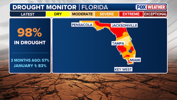
Latest Drought Monitor showing 98% of Florida is now experiencing some level of drought.
Lake Okeechobee has plummeted to just 12.63 feet—nearly two feet below its seasonal average—threatening the primary water source for South Florida’s agriculture and millions of residents.
The St. Johns River Water Management District has declared a Phase I Water Shortage, urging voluntary conservation as groundwater levels hit the bottom 15th percentile.
With the dangerously dry conditions, the Florida Forest Service is warning of extreme wildfire potential. Already, dozens of counties have implemented mandatory burn bans to prevent a catastrophic start to the spring fire season.
Governor Ron DeSantis recently signed an executive order to expedite recovery for farmers who have seen livestock ponds dry up and winter crops stunted by the dual-threat of January freezes and ongoing lack of rain.
Computer forecast models aren't showing much snow for the millions that live along Interstate 95 this weekend - so why is anyone still talking about it?
Meteorologists in the FOX Forecast Center say this could be a case of a 'boom or bust' setup for someone in the Northeast.
Looking across the publicly available ECMWF, ECMWF-AI, GFS, and CMC ensembles, there are 150 total members. Of those, 107 members show little to no impactful snow. But 43 members crank out 8"+ somewhere in the region. That’s a pretty sharp split.
Computer forecast model ensembles are weather forecasting tools that run multiple simulations (members) of a model simultaneously, each with slightly different initial conditions or physics, to predict a range of future atmospheric possibilities rather than a single, likely outcome. By analyzing the spread of these scenarios, forecasters can assess the uncertainty of a forecast and determine probabilities for events like rain or extreme temperatures.
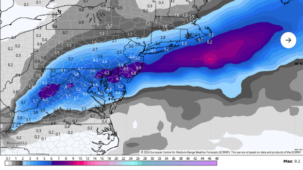
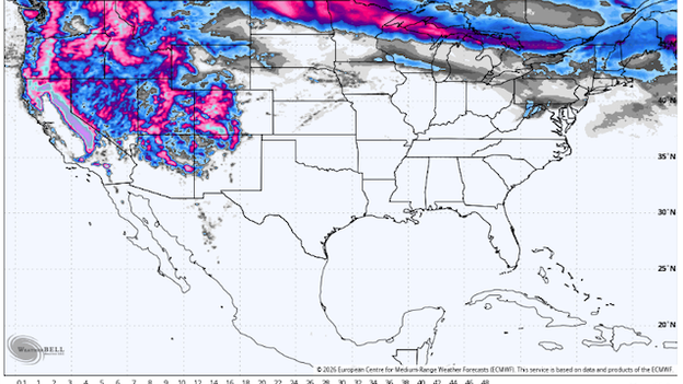
One member of the European Centre for Medium-Range Weather Forecasts (ECMWF) ensembles showing huge snow amounts for the Northeast this weekend. (Source: WeatherBELL)
Roughly one-third of the members are high-end solutions. That’s enough to skew the ensemble mean upward, even though the majority of members show minimal impacts. So when you see the mean snow total tick up, it doesn’t necessarily mean confidence in widespread snow has increased, but it does mean a smaller cluster of big solutions is pulling the average higher.
If you shift your focus to the 50th percentile (median), you get a much different story. The more representative numbers land closer to 1-2", because most members are clustered around little or no snow. That’s a much more realistic baseline given the distribution until we get higher confidence.
That doesn’t mean the 'boom' scenario can be dismissed. It clearly exists in the data. But statistically speaking, it’s the lower-probability outcome.
And the risk zone happens to be the most populated in America: I-95 between DC and NYC. That alone is the main reason we are closely watching.
Forecasters say temperatures are marginal, or close to 32°F. Snow ratios would probably be 10:1 or less, meaning wetter, heavier snow if it does fall.
Bottom line: this is a high-impact, low-probability snow threat. The mean snow map isn’t the story. The story is in the distribution. In these setups, the mean can mislead while the percentiles and probabilities tell you what’s really going on.
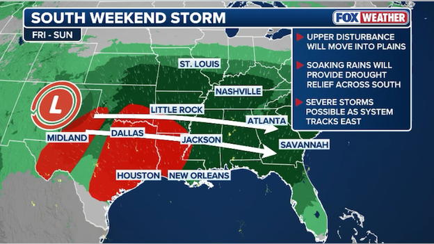
While Friday focuses on the Southern Plains, Saturday marks a significant expansion of the severe weather threat as a potent atmospheric disturbance slides toward the Mississippi Valley.
Meteorologists are tracking a shortwave trough—essentially a pocket of intense energy—that is expected to tap into a surge of humid, 60-degree air flowing off the Gulf of America.
This collision is set to ignite a line of storms that will stretch from Texas and Oklahoma through Louisiana and Mississippi.
As the cold front surges eastward on Saturday afternoon, a line of storms is likely to form. The primary danger with this setup is damaging straight-line wind gusts that could knock out power or down tree limbs.
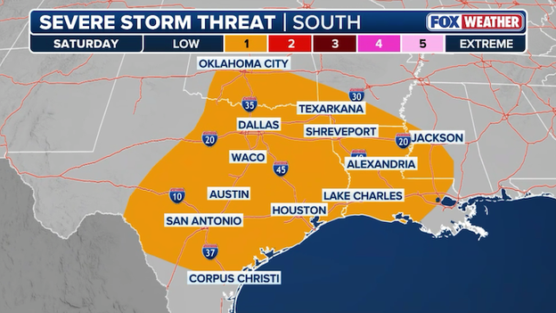
Severe storm threat has increased across Texas and Oklahoma for Saturday afternoon.
While the atmosphere isn't perfectly primed for a major tornado outbreak, there is a low-probability risk for a couple twisters along the middle Texas Coast and into southwest Louisiana, particularly if any individual cells can form ahead of the main line.
Communities in East Texas and the Ark-La-Tex region should remain weather-aware by late Saturday afternoon, with the threat shifting into Mississippi and Alabama during the overnight hours.
For those with Valentine's Day dinner reservations or travel plans, this is a weekend to keep the FOX Weather App's notifications turned on.
While the storms may be modest compared to springtime outbreaks, the combination of high moisture and strong upper-level winds means any storm that develops will have the potential to disrupt your holiday plans.
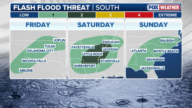
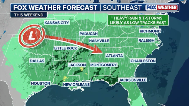
Heavy rain and strong thunderstorms will increase the threat of flash flooding this weekend in the South.
A relentless multi-day weather system is set to turn Valentine’s weekend into a widespread washout for millions across the South. Moisture surging from the Gulf of America is providing high-octane fuel for a series of slow-moving storms stretching from Texas to the Carolinas.
FOX Weather meteorologists are particularly concerned about the risk of training thunderstorms—repeated rounds of heavy rain hitting the same locations—which could lead to significant flash flooding in urban areas and low-lying neighborhoods through Sunday.
The heaviest rain is expected to fall in a broad swath across Louisiana, Mississippi, Alabama, and Arkansas, where widespread totals of 1 to 4 inches are likely. However, in areas where these storms stall or overlap, localized totals could spike as high as 5 or 6 inches.
With abundant moisture streaming northward, this "February Fire" setup means the rain will be exceptionally efficient, turning romantic outdoor plans into indoor-only affairs for the duration of the holiday weekend.
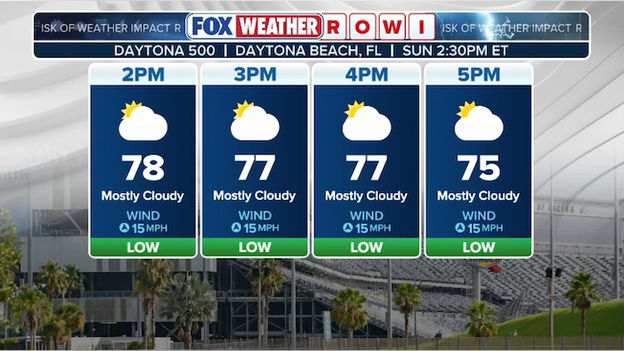
FOX Weather's Risk Of Weather Impact (ROWI) is currently "low" for Sunday's Daytona 500.
NASCAR officials are keeping a close eye on the forecast for the 2026 Daytona 500 as a low-pressure system threatens to bring showers and to the track this Sunday.
Because racing at 200 mph is impossible on a damp surface, the sanctioning body has the authority to shift the green flag time to an earlier window if it means outrunning an approaching storm—a move they successfully executed for the 2025 race.
If rain does materialize during the event, the Speedway’s elite Air Titan drying systems can typically have the 2.5-mile asphalt oval race-ready in roughly 90 minutes to three hours, depending on the humidity.
However, if persistent rain prevents the track from drying, NASCAR may utilize its Weather Protection Program, which allows fans to exchange tickets if the "Great American Race" is ultimately postponed to Monday.
Right now, FOX Weather's Risk Of Weather Impact (ROWI) is "low," meaning weather is not expected to impact the race. Forecasters warn that even isolated showers could threaten the race and the forecast is still subject to change a few days out.
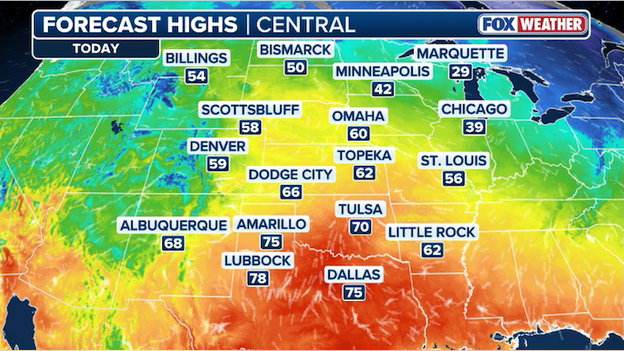
Temperatures are expected to surge into the 60s and 70s throughout the Central U.S. this afternoon.
Millions of Americans are feeling the heat ahead of Valentine's Day as a "blowtorch" of warm air kicks winter off the map today.
FOX Weather meteorologists expect high temperatures to reach into the 60s and 70s this afternoon from Texas to North Dakota - some 30 degrees above average for mid-February. That heat is expected to persist through the weekend as a powerful storm sweeps across the South.
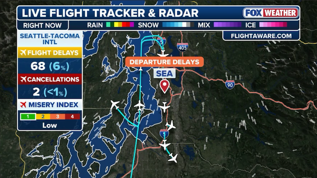
SeaTac Airport is experiencing delays due to low clouds in the Washington area.
Seattle-Tacoma International Airport (SeaTac) is currently facing operational constraints due to low ceilings. This typical Pacific Northwest gray-out means clouds are sitting low enough to force air traffic controllers to increase the spacing between arriving aircraft, naturally leading to a backlog of flights.
Currently, general arrival and departure delays are remaining relatively manageable at 15 minutes or less, though this number is expected to increase through the afternoon.
While the current delays are minor, low ceilings often result in "gate holds," where your plane is held at its origin to manage the volume of arrivals in Seattle.
If you are heading to the airport, keep a close eye on your airline's app for real-time gate changes or pushback adjustments.
The four-person crew will launch to the International Space Station aboard the SpaceX Dragon spacecraft tomorrow morning.
NASA and SpaceX had delayed the launch of the Crew-12 mission on Tuesday due to weather.
The previous Crew-11 mission was cut short due to an undisclosed medical issue with one of the crewmembers.
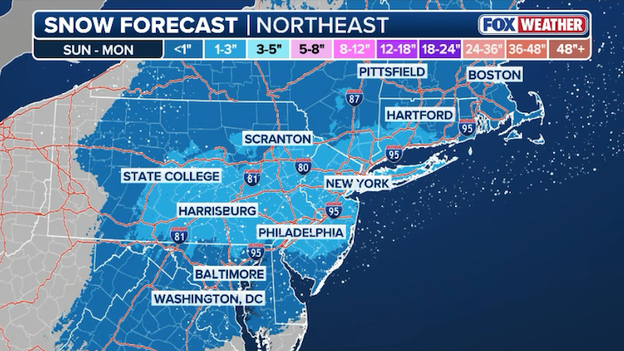
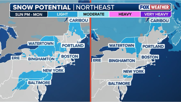
Latest snow forecast from FOX Weather showing an inch or two of snow possible for the Mid-Atlantic and Northeast through Monday.
While the chance of a blockbuster blizzard has faded, the FOX Forecast Center warns that the I-95 corridor isn't entirely in the clear for the upcoming holiday weekend.
Despite an ongoing thaw, pushing temperatures into the 40s and 50s, a complex storm system tracking through the South is expected to graze the Mid-Atlantic and Northeast late Sunday into Monday.
Meteorologists are closely monitoring the transition zone, where just a slight shift in the storm's track could determine whether cities like Washington, D.C. and New York City see a cold rain or a couple inches of snow.
According to the latest analysis, there is notable model ensemble support for a light snow event along the I-95 corridor.
While individual operational models have vacillated on the exact rain-snow line, the broader ensemble means—which average dozens of potential outcomes—suggest that enough cold air may linger at the surface to support a few inches of accumulation.
This wintry fringe remains the primary forecast hurdle for President's Day travel, as even minor accumulations could create slick spots on roads that have only recently begun to melt out from January’s deep freeze.
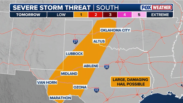
Latest severe storm threat map showing the threat for hail extending into Oklahoma on Friday night.
According to the FOX Forecast Center, high-resolution models have just pulled the threat zone further north as unseasonably warm air and Gulf moisture surge into central Oklahoma faster than initially anticipated.
This updated setup provides the fuel needed for storms to turn severe as they collide with an advancing boundary, placing the Oklahoma City metro in the path for potential large hail and damaging wind gusts through Friday night.
A potent storm system will sweep through the South with potential severe storms and flash flooding this weekend.
Millions across the South are bracing for a Valentine's Day washout as a powerful 1,000-mile-wide storm system sweeps through the region, bringing a risk of severe thunderstorms and flash flooding. FOX Weather is tracking widespread rain totals of 1 to 4 inches from Texas to the Carolinas, with localized pockets of up to 6 inches where storms train over the same locations. The most intense activity is expected on Saturday, particularly across Louisiana, Mississippi, and Alabama, where Gulf moisture could fuel damaging wind gusts and isolated tornadoes, potentially disrupting holiday travel and outdoor celebrations.
After weeks of dry weather across the West, the Rockies are finally beginning to receive much-needed snow.
Many snowpacks throughout the region are between 25-60 percent below their average — a critical deficit for ski resorts, as well as the water supply for drinking and agriculture in the summer months.
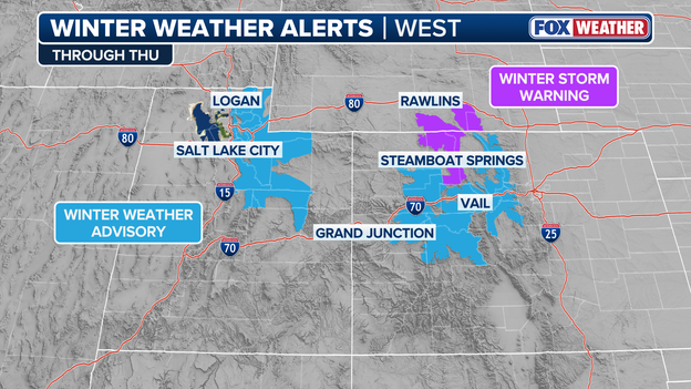
Winter Weather Alerts
Winter Weather Alerts are in place across parts of Utah, Wyoming and Colorado through Thursday.
After a historically dry January that saw California’s snowpack plummet to just nearly half of normal, a major pattern shift is finally delivering the "insane" snow totals needed to rescue the state’s frozen reservoir.
The FOX Forecast Center is tracking a series of relentless storms that could dump 5 to 10 feet of snow in the high country through next week.
Until this week, the Sierra Nevada was enduring a critical moisture deficit. A warm, dry January wiped out early-season gains, leaving the statewide snowpack at a third of typical numbers.
The Northern Sierra has been the hardest hit, sitting at just 39% of normal to date, while the Southern Sierra has fared slightly better at 72%.
This week's snow is just the opening act. While the first wave is delivering a refresh of 12 to 36 inches, a much more potent, slow-moving system is forecast to arrive late Saturday.
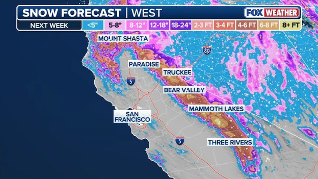
Latest snow forecast from FOX Weather showing more than 8 feet of snow for the Sierra Nevada through next week.
This "monster" storm is projected to bring feet of heavy snow to mountain passes over several days, potentially boosting the statewide snowpack by double digits in a single week.
Since the Sierra snowpack traditionally supplies 30% of California’s freshwater, this "insane" February surge is critical for replenishing the state's water infrastructure before the dry summer months.
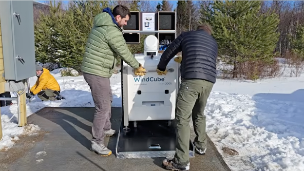
Mount Washington Vaisala WindCube 200S LiDAR Installation (Source: YouTube)
A new era of high-definition weather tracking has arrived in the White Mountains of New England. In a first for New Hampshire, the Mount Washington Observatory (MWOBS) has installed a ground-based scanning LiDAR system at Bretton Woods to map the atmosphere in unprecedented 3D detail.
This cutting-edge "laser radar"—a Vaisala WindCube 200S—allows meteorologists to peer into the boundary layer, the turbulent slice of air where terrain meets sky and fuels the region's notoriously lethal weather.
This doppler scanner is monumental for our wind, cloud, and general lower-atmosphere studies, especially regarding the boundary layer, which heavily influences Mount Washington’s uniquely extreme weather.
Situated at 1,600 feet, the scanner sends vertical and horizontal laser beams several kilometers into the sky, measuring how winds shift as they collide with the Presidential Range.
The system provides 360-degree data coverage for nearly nine miles, meaning researchers can now monitor wind profiles directly over the summit of Mount Washington in real-time.
By tracking clouds, aerosols, and turbulence, the LiDAR helps scientists understand why winds intensify so dramatically over complex terrain, providing a bankable look at atmospheric dynamics that traditional stations simply can't capture.
The project, funded by a congressional request from U.S. Senator Jeanne Shaheen, is designed to serve both the scientific community and the public.
Beyond improving high-resolution forecasting, the data will be used to enhance safety for the thousands of hikers and skiers who visit the range each year.
MWOBS says it plans to integrate this 3D mapping into their public website, allowing anyone to see the invisible forces shaping the "home of the world's worst weather."
As the Pacific Ocean shows signs of a rapid shift, FOX Weather meteorologists are closely watching how a brewing El Niño could rewrite the script for the 2026 Atlantic hurricane season.
While El Niño is often viewed as a "shield" for the Atlantic, history proves that even in a "quiet" year, it only takes one breakthrough storm to define a season.
The transition from our current La Niña to a likely El Niño by late summer 2026 creates a hostile environment for tropical systems.
The primary mechanism is vertical wind shear—the change in wind speed and direction with height. During El Niño years, the subtropical jet stream strengthens, sending high-speed westerly winds across the Atlantic and Caribbean. These winds act like a scissors, effectively cleaving the tops off developing tropical depressions before they can organize into powerful hurricanes.
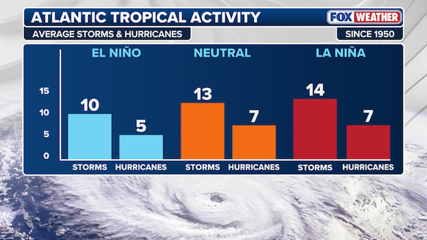
El Niño years typically produce fewer tropical storms and hurricanes in the Atlantic Basin.
While the statistical probability of a major hurricane landfall drops during El Niño, this protection is never a guarantee. History is littered with catastrophic exceptions like Hurricane Andrew (1992), which became one of the most destructive Category 5 hurricanes in U.S. history, and Hurricane Alicia (1983) which clobbered the Texas coast, causing billions in damage.
The current 2026 outlook suggests that while we could see a lower total number of named storms, the presence of exceptionally warm Atlantic sea surface temperatures could still allow any storm that avoids the wind shear to intensify rapidly.
For residents along the Gulf and East Coasts, the brewing El Niño might lower the odds, but it doesn't lower the stakes.
NASCAR drivers and fans are eyeing this weekend's cross-country storm, ahead of the unfurling of the green flag Sunday afternoon at the Daytona 500.
Zach Dean, NASCAR columnist for Outkick.com, discussed the impact of rain on the big race with FOX Weather Meteorologists Stephen Morgan and Marissa Torres.
Heavy rain and severe thunderstorms are expected to slam the South this weekend.
A powerful, 1,000-mile-wide storm system is set to sweep across the South this Valentine’s Day weekend, bringing widespread drenching rain and the threat of severe thunderstorms from Texas to the Carolinas. Rain totals are expected to reach 1 to 4 inches, with localized "training" storms potentially dumping up to 6 inches, which could trigger flash flooding in urban areas and low-lying neighborhoods.
Click here for live updates from FOX Weather on this growing storm threat.
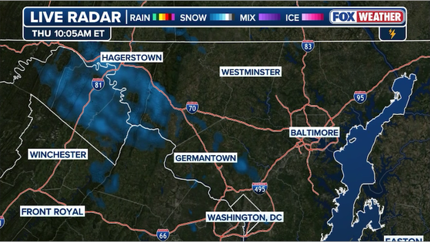
Latest radar image showing flurries flying west of Baltimore and Washington this morning.
Flurries are flying west of Interstate 95 this morning under a deck of thick clouds. Those flurries are expected to continue into early afternoon, but accumulating snow is unlikely.
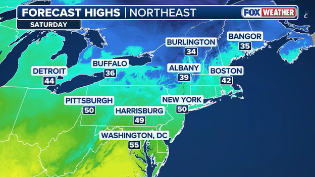
Temperatures are predicted to warm into the 40s and 50s in the Northeast on Saturday.
"Slush season" has arrived. Temperatures in major hubs like Philadelphia and NYC are flirting with the mid-30s and 40s today, but the ground remains chilled from the recent deep freeze.
This creates a "slushie" effect where the top layer of snow melts into a gray soup while the bottom layer remains a treacherous sheet of ice.
Even with temperatures rising, the February sun angle is still relatively low. This means that while your lawn might look clear, north-facing stoops, alleyways, and parking spot savers (those giant piles of gray snow) will likely linger for days as frozen obstacles.
As we head into the Valentine's and President's Day weekend, a shift toward even milder air and potential rain will turn those remaining snowbanks into mini-lakes, making high-quality waterproof boots the must-have fashion accessory of the week.
A pattern change is shifting America's weather with coast-to-coast impacts.
- El Niño 2026 watch: A new report from the Climate Prediction Center reveals how likely El Niño will develop this summer, potentially suppressing Atlantic hurricane activity this year.
- Sierra snow surge: After weeks of unusually dry weather, several rounds of mountain snow are impacting California. An even stronger, slower-moving system is expected to arrive late Saturday, potentially dropping feet of heavy snow through Washington’s Birthday weekend.
- Northeast snow threat: While the Atlantic corridor is seeing warmer temperatures now, forecasters are closely watching for more wintry weather to arrive this weekend.
- Valentine's flash flood risk: Deep Gulf moisture is set to collide with a slow-moving front, threatening holiday plans from Texas to the Carolinas. Major hubs like Atlanta and Dallas are under the gun for heavy rain and flight delays starting Friday night. Click here for live updates from FOX Weather.
After weeks of relentless arctic blasts and impactful winter storms, a significant pattern flip is providing the Northeast with a much-needed thaw. High-pressure is replacing deep-digging troughs, shifting the focus of cold and snow to the Western U.S. and allowing unseasonably mild air to flood the Atlantic corridor.
For millions from D.C. to Boston, this means a break from the shovel; daily highs are projected to climb into the 40s and even 50s through next week, effectively putting winter on a temporary hiatus.
European Centre for Medium-Range Weather Forecasts (ECMWF) model showing little to no snow in the East over the next 7 days. (Source: WeatherBELL)
The upcoming week’s forecast is remarkably quiet, with most major metro areas seeing little to no snow accumulation. While this weekend's big storm may bring spotty rain or a light wintry mix to the interior mountains late this weekend, coastal hubs like New York City and Philadelphia are trending toward a snow-free stretch through next week.
This prolonged reprieve is helping to dent the glacial shell that has covered the region, providing ideal conditions for travel and outdoor plans as we head toward the President's Day holiday.
The multi-year grip of La Niña is finally loosening. According to the latest update from the Climate Prediction Center, there is now a 60% chance that the Pacific will transition to "ENSO-neutral" conditions between in the weeks ahead.
While chilly sea surface temperatures still linger in the central Pacific, a significant surge of subsurface warmth is moving eastward—acting like an underwater heater that is rapidly eroding the cold La Niña base.
This shift means the reliable "steering wheel" of our winter weather is being removed, likely leading to a more variable and unpredictable spring for much of the U.S.
Looking further ahead, the "neutral" phase is expected to persist through the summer, but a bigger flip is on the horizon.
Forecast models are now signaling a 50-60% chance of El Niño forming by late summer or fall of 2026.
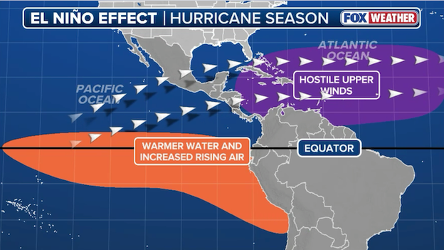
El Niño typically increases wind shear across the Atlantic Basin, suppressing tropical development.
If this rapid transition verifies, it could have major implications for the 2026 hurricane season, as El Niño typically increases wind shear in the Atlantic, which can help suppress storm development.
For now, we are in a "wait and see" period as the atmosphere begins to decouple from the old La Niña pattern and resets for the year ahead.
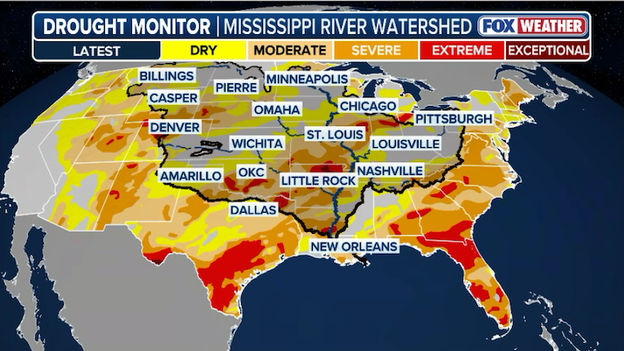
Latest U.S. Drought Monitor shows much of the South is experiencing significant drought conditions.
FOX Weather has just received the latest weekly U.S. Drought Monitor and it shows worsening drought conditions across the Southern U.S.
According to the report, conditions worsened followed another mostly dry week in the High Plains, western Midwest, the eastern southern Plains of Oklahoma and Texas eastward into the Lower Mississippi Valley and the western Carolinas.
Despite scattered precipitation in some locations, rain and snow deficits continue to grow, with drying soils and low streamflows supporting intensification of drought conditions.
In southern Georgia and Florida, fire danger continues to rise.
Wildfire activity increased during the week, and multiple water management districts, including the South Florida Water Management District, have issued water shortage advisories or warnings due to declining groundwater and surface water levels.
The report says from August 14, 2025, through February 10, 2026, Rio Grande City, Texas ranks as the fifth warmest and third driest on record dating back to 1928, while McCook, Texas ranks as the second warmest and sixth driest since 1942 according to NWS and NOAA data.
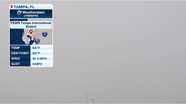
Weatherstem camera at Tampa International Airport showing very dense fog shrouding the airport.
Tampa is experiencing travel trouble this morning as a Dense Fog Advisory remains in effect until 10:00 a.m. ET, covering Hillsborough and surrounding counties.
Visibility at Tampa International Airport (TPA) and across major corridors like I-75 has dropped to a dangerous quarter-mile or less, forcing several early morning flights into delays. The fog is expected to thin out by late morning, leading to a mostly sunny afternoon.
The Climate Prediction Center is set to release an update on the current status of La Niña in the Pacific, and the expected development of El Niño later this year.
FOX Weather will provide comprehensive coverage when the report is released later this morning.
While millions in the South prepare for a rainy washout, the Northeast and Mid-Atlantic are eyeing a complex forecast for the Valentine’s and President's Day weekend. After a brief thaw earlier this week, a clash of seasons is set to unfold as a sprawling weekend storm brings the threat of snow back to the region.
Forecast confidence is currently split between "wet and white" as a surge of milder air battles lingering cold entrenched in the interior. The FOX Forecast Center says most computer model guidance has pulled back when it comes to snow for the region. As of now, it appears the higher terrain of West Virginia and Maryland could still see flakes late Sunday into Monday.
Computer forecast models show little snow accumulation across the Northeast this weekend.
For major cities like Washington D.C., Philadelphia, and New York City, the forecast is welcome news. While early guidance suggested a major hit, the most recent trends favor a brief rain-snow mix or just plain rain altogether. Accumulating snow appears unlikely, though a slight shift in the storm's track could easily push numbers higher.
You’ve reached the beginning of this live coverage.