Live updates: Nor’easter ‘bomb cyclone’ hammers Carolinas with record snow, intense winds
Live updates: Nor’easter ‘bomb cyclone’ hammers Carolinas with record snow, intense winds
Download the AppWinter Storm HQ LIVE coverage continues
View postCoverage for this event has ended.
LIVE coverage has ended here, but FOX Weather is providing 24-7 updates all day and night to help keep you and your family safe.
After suffering a 5 point loss to the Charlotte Hornets in North Carolina, winter weather kept the San Antonio Spurs in town for longer than planned.
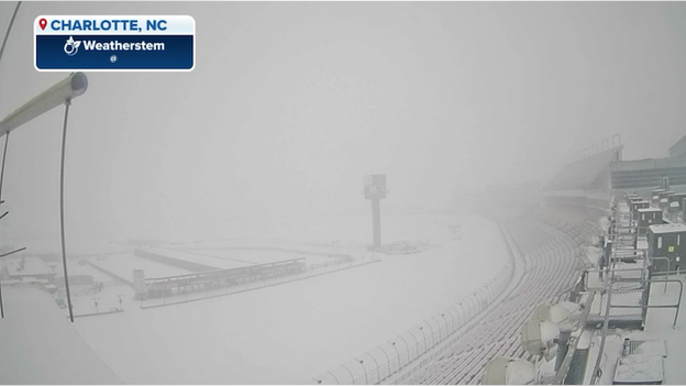
Heavy snow courtesy of a strong nor'easter slammed the Carolinas, dumping snow in Charlotte, causing severe delays and over 1,000 flight cancellations at Charlotte Douglas International Airport.
The NBA announced Saturday that the Spurs home game against the Orlando Magic in San Antonio originally scheduled for 3 p.m. on Sunday had been pushed back three hours to tip off at 6 p.m. due to the inclement weather.
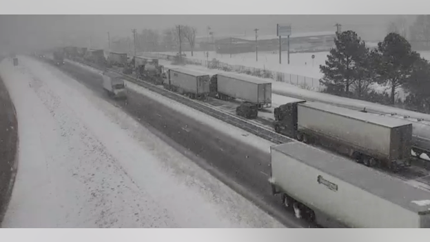
The North Carolina State Emergency Response Team has deployed resources from the North Carolina National Guard, North Carolina Department of Transportation and the North Carolina State Highway Patrol to respond to a major pile-up that closed portions of Interstate 85.
According to the North Carolina State Highway Patrol, the northbound lanes of I-85 between mile markers 60-63 have reopened in Cabarrus County.
Local authorities announced that dozens of vehicles, including over two dozen tractor trailers, were stranded on the highway on Saturday.
For the latest conditions, visit drivenc.gov.

NC Emergency Management announced on Facebook that the North Carolina State Emergency Response Team was deployed to clear up a pile up on I-85.
The North Carolina State Emergency Response Team has deployed resources from the North Carolina National Guard, North Carolina Department of Transportation and the North Carolina State Highway Patrol to respond to a major pile-up that has closed portions of Interstate 85, according to NC Emergency Management.
According to drivenc.gov, I-85 is currently closed between the Exit 60 and Exit 63 due to weather conditions.
Local authorities announced that dozens of vehicles, including over two dozen tractor trailers, were stranded on the highway.
The emergency response team is collaboratively working to clear the stranded vehicles form the roadway in order to reopen I-85.
For the latest conditions, visit drivenc.gov.
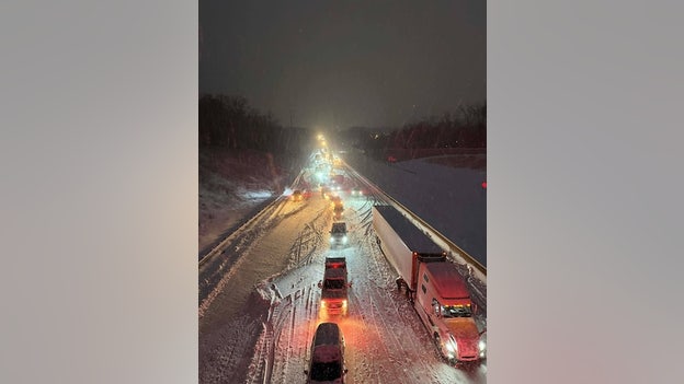
Image courtesy of the City of Kannapolis.
Local police, the North Carolina State Highway Patrol and the North Carolina National Guard are responding and assisting stranded motorists on Interstate 85, as a stretch of the major highway has been closed, local officials announced on Facebook.
According to drivenc.gov, I-85 is currently closed between the Exit 60 and Exit 63 due to weather conditions.
Dozens of vehicles, including over two dozen tractor trailers, are stuck on the highway.
The North Carolina State Highway Patrol responded to 750 collisions and 817 calls for service across an 18 hour window from midnight to 6 p.m. on Saturday as winter weather impacts from the powerful nor'easter continue to create chaotic travel conditions across parts of North Carolina.
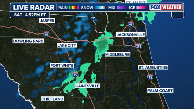
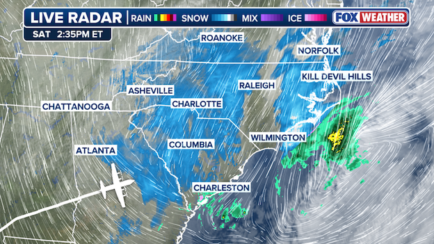
Radar showing light snow and flurries approaching Jacksonville and Gainesville, Florida.
The FOX Forecast Center says snow is on the move in North Florida this afternoon. Radar shows light snow or flurries approaching the Jacksonville and Gainesville areas as dangerously cold air sweeps south across the Sunshine State.
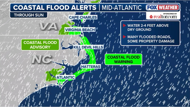
Coastal Flood Warnings are in effect for North Carolina's Outer Banks and Hatteras Island through Sunday.
As the "bomb cyclone" intensifies off the coast tonight, eastern North Carolina is facing a dangerous surge of water. 2 to 4 feet of inundation is forecast for low-lying shorelines and tidal waterways. A Coastal Flood Warning remains in effect for the Northern Outer Banks and Hatteras Island, where peak impacts are expected between overnight and early Sunday morning as hurricane-force gusts up to 75 mph drive water both from the ocean and the Pamlico Sound. Travel along Highway 12 is expected to become impossible or even life-threatening due to significant ocean overwash and flooding.
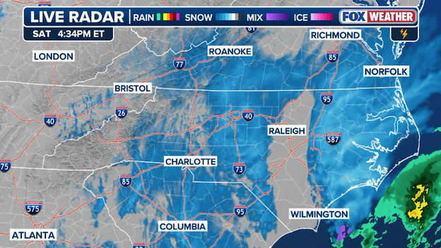
As a massive nor'easter rapidly intensifies into a bomb cyclone off the East Coast, residents in Raleigh are asking "where's the snow," while their neighbors to the west endure a record-shattering snowfall.
Charlotte has already shattered its daily record for January 31 with over 6 inches of snow, parts of the Triangle have been plagued by a stubborn "dry slot"—a pocket of dry air that effectively starves the region of significant moisture.
Radar image showing the "dry slot" over Raleigh, North Carolina where snow totals are expected to be significantly less than original forecasts.
This atmospheric snub is the difference between the 5-to-8-inch totals FOX Weather officially called for and the more modest 3-5 inches currently materializing in the Piedmont.
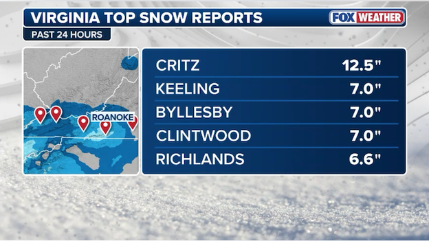
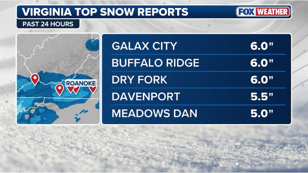
Top snow reports from Virginia as of 4:30 p.m. ET Saturday.
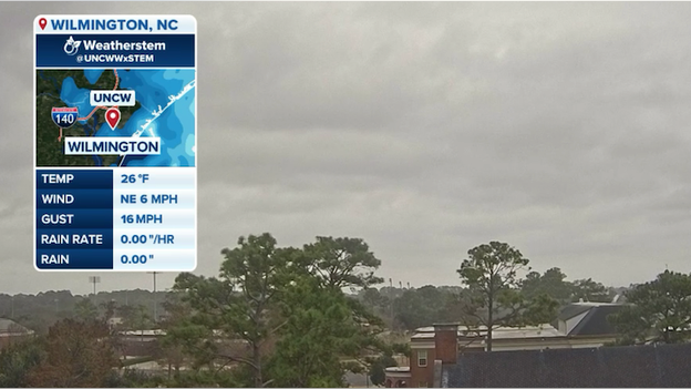
Weatherstem camera on the University of North Carolina Wilmington campus.
Snow is now visibly flying on the University of North Carolina Wilmington campus as the intensifying nor'easter "bombs out" off the coast. The university's Weatherstem camera captures the deteriorating conditions in real time, showing flakes and increasing winds as the region prepares for heavy snow.
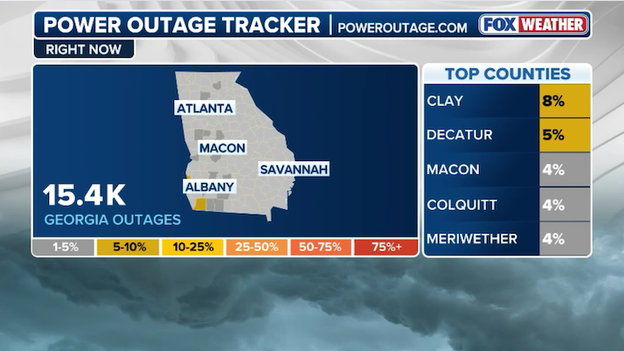
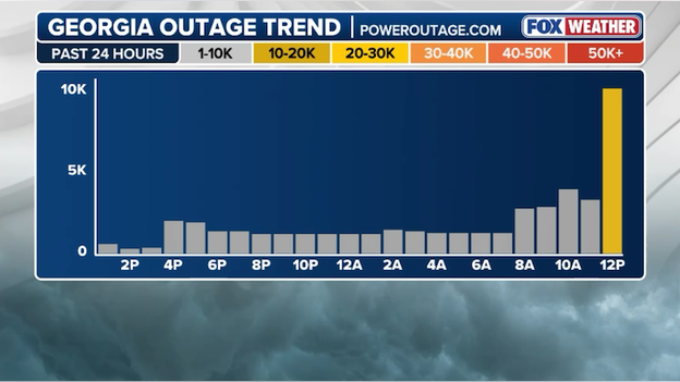
More than 15,000 customers are now without power across Georgia. (PowerOutage.com)
Data from PowerOutage.com shows thousands of people are without power across Georgia as snow and frigid air charge across the state. More than 15,000 utility customers are without electricity right now, a number that has steadily increased in recent hours.
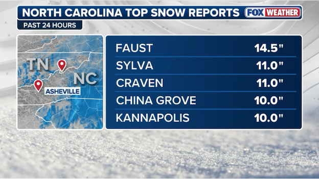
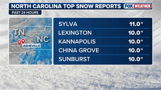
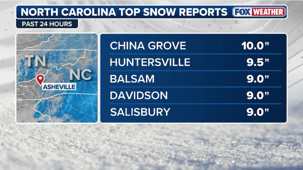
Top snow reports from North Carolina as of 4:15 p.m. ET Saturday
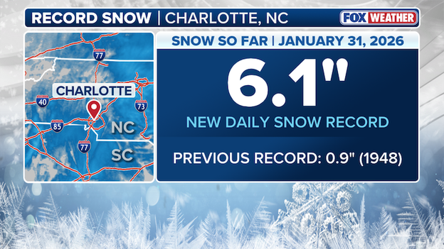
6.1 inches of snow has already been recorded at Charlotte Douglas International Airport, shattering the daily snow record for January 31.
Charlotte, North Carolina has officially shattered its daily snow record for January 31, with 6.1 inches of accumulation already reported at the airport, easily surpassing the previous 1948 record of 0.9 inches. The storm is far from over, as heavy snow bands continue to linger over the metro area, potentially pushing final totals toward an impressive 8-12 inches before it winds down.

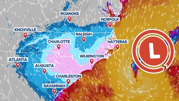
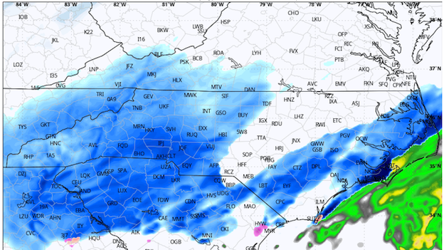
Radar image showing widespread and heavy snow falling throughout the Carolinas, Virginia, and Georgia.
A powerful nor'easter is rapidly intensifying into a bomb cyclone has clobbered the Carolinas, delivering the region's heaviest snow in years. Charlotte has officially shattered its daily record for January 31, with a reported 6.1 inches of snow already accumulating at the airport, far surpassing the previous 1948 benchmark of 0.9 inches. Across North Carolina, the storm has created hazardous travel on major interstates like I-77 and I-85 and triggered more than 12,000 flight disruptions across America. With heavy snow banding expected to continue through Saturday evening, some areas of the Carolina Piedmont could see final totals reaching 12 inches before the storm pulls away.
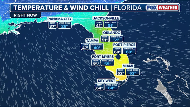
Temperatures are tumbling across North Florida as arctic air rushes south.
Temperatures are plummeting across North Florida as crazy cold air surges south. In Panama City, Florida, the temperature has tumbled to 37°F as of 4 p.m. ET, but feeling like 26°F thanks to icy northwest winds. That frigid air will make it all the way to Miami on Sunday with temperatures approaching the freezing mark (32°F) by sunrise.
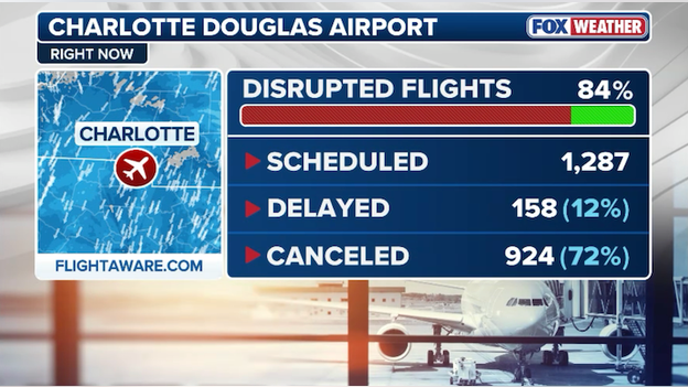
Nearly three-quarters of all scheduled flights have been canceled at Charlotte Douglas International Airport today.
Flight operations at Charlotte Douglas International Airport (CLT) have ground to a near-halt as a powerful nor'easter continues to intensify. According to the latest data from FlightAware, 72%—nearly three-quarters—of all scheduled flights at the airport have been canceled so far today. These widespread disruptions come as heavy snow and intensifying winds from the "bomb cyclone" overwhelm ground operations, forcing major carriers to proactively slash their Saturday schedules.
Top snow reports from Virginia as of 3:45 p.m. ET Saturday.
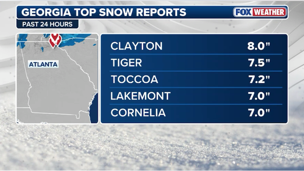
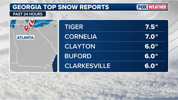
Top snow reports from Georgia as of 3:45 p.m. Saturday.
Top snow reports from North Carolina as of 3:45 p.m. Saturday.
Cape Cod, Massachusetts residents are breathing a sigh of relief as a potentially high-impact nor'easter has shifted its track, sparing the region from a worst-case "snow-pocalypse" scenario.
While the storm is rapidly intensifying into a bomb cyclone currently burying the Carolinas in heavy snow, the latest data from the FOX Forecast Center shows the storm center tracking significantly farther east into the Atlantic. This slight shift of just 50 miles has drastically reduced predicted snow totals, with FOX Weather now calling for a mere 1 to 3 inches across the Cape and Islands on Sunday, rather than the foot or more initially feared.
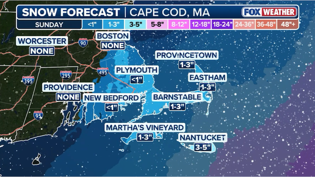
Latest snow forecast from FOX Weather showing just 1-3 inches for Cape Cod and southeastern Massachusetts.
So why the shift in recent days? The primary "savior" for New England is a stubborn area of dry high pressure over central Canada and interior New England. This high-pressure system is acting like an atmospheric defensive wall, diverting the storm’s energy and moisture shield further out to sea. This "game of miles" has left most of the region on the dry side of the action, though some light snow and powerful winds are still expected on Sunday.
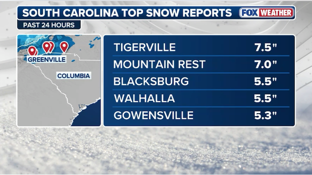
Top snow reports from South Carolina as of 3 p.m. ET Saturday.
Top snow reports from North Carolina as of 3 p.m. ET Saturday.
As a massive nor'easter intensifies into a "bomb cyclone" along the Eastern Seaboard, FlightAware data reveals that more than 12,200 flights have been disrupted nationwide this weekend. The historic storm has left major hubs like Atlanta (ATL) and Charlotte (CLT) struggling with near-total operational shutdowns. Major carriers including Delta, American, and Southwest have issued wide-ranging travel waivers as they wait for conditions to improve.
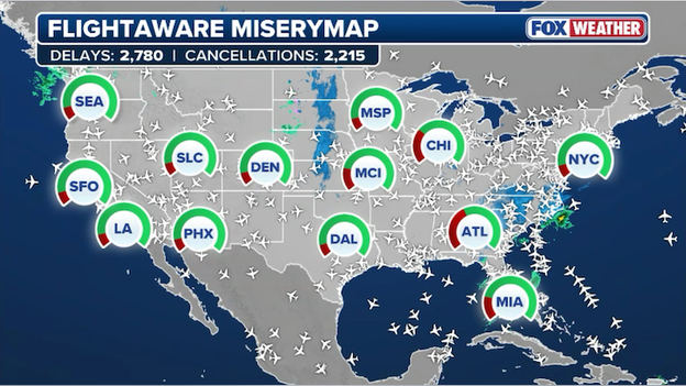
FlightAware MiseryMap showing flight disruptions across the U.S. as the nor'easter rages along the East Coast.
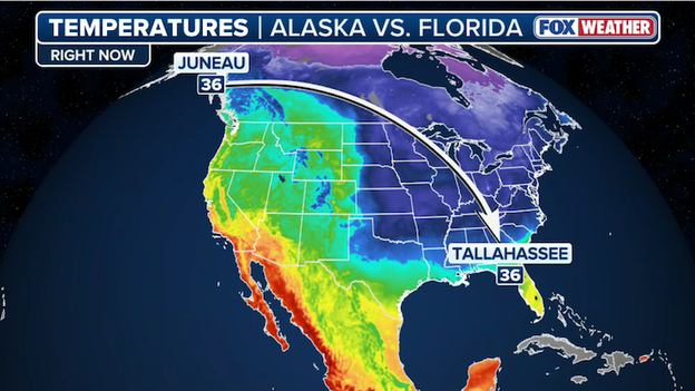
The temperature in Juneau, Alaska mirrors that of Tallahassee, Florida right now (36°F).
In a rare atmospheric alignment, the temperature in Tallahassee, Florida, has plummeted to match the 36°F reading in Juneau, Alaska, as of Saturday afternoon. This unusual convergence occurs as a massive Arctic blast triggers widespread Extreme Cold and Freeze Warnings across the Florida Panhandle, while the Alaskan capital experiences a relatively mild mid-winter day.
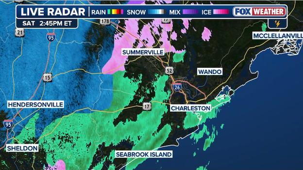
Radar image showing snow moving into Charleston, South Carolina.
The flakes are flying in Charleston, South Carolina this afternoon as the powerful nor'easter intensifies off the East Coast. The National Weather Service in Charleston reports it is snowing at its office at the Charleston International Airport.
Hurricane Hunters are flying into the nor'easter to gather vital atmospheric data for computer forecast models.
An Air Force Reconnaissance C-130J is heading into the dangerous coastal storm right now to gather vital data for forecasters. It will gather measurements about the atmosphere from top to bottom so that computer forecast models can get the most clear picture of how the storm is intensifying. The Hurricane Hunters often fly into major winter storms and atmospheric rivers to give forecasters better data that has been proven to improve forecasts.
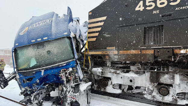
Photo from Gastonia Police Department on X showing a train that smashed into a semi truck.
On Saturday afternoon, a Norfolk Southern freight train collided with a semi-truck near downtown Gastonia at the intersection of Poplar Street and Airline Avenue. While the crash caused significant damage to the truck, the driver was able to escape without injuries.
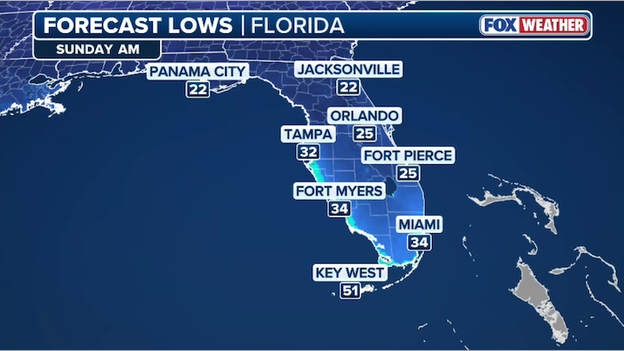
Forecast low temperatures for Florida on Sunday morning.
South Florida is bracing for a historic weather event as an unyielding blast of arctic air plunges the region into its coldest temperatures in over 15 years. The National Weather Service in Miami has extended Freeze Warnings into the metro areas of Broward and Miami-Dade counties, where temperatures are forecast to drop into the mid-30s overnight Saturday into Sunday morning. This rare "Super Bowl of cold" is expected to bring wind chills as low as the mid-teens and 20s, potentially shattering cold records that have stood for decades.
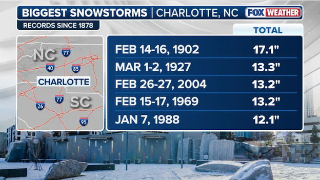
Charlotte's top 5 snowstorms on record.
As a powerful nor'easter intensifies into a bomb cyclone off the coast, Charlotte, North Carolina is currently facing its most substantial winter threat in over two decades. The latest FOX Weather forecast indicates the Queen City could pick up nearly a foot of powdery snow, a total that would rival the historic 13.2-inch storm of February 2004.
PowerOutage.com reports power outages have spiked in Georgia over the past two hours.
Data from PowerOutage.com shows power outages spiking across Georgia in the past few hours. Right now, more than 12,000 customers are without power, mostly across Fulton and Gwinnett Counties in the Atlanta Metro area.
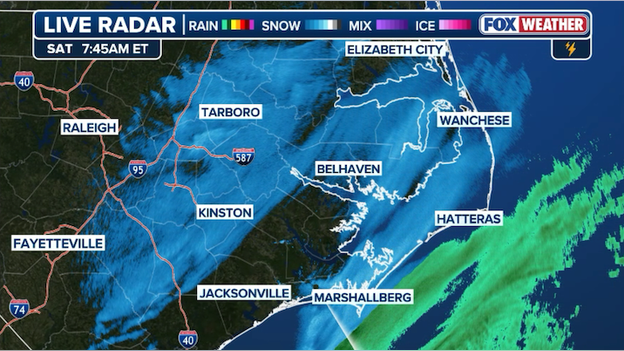
Radar showing heavy snow hitting eastern North Carolina with limited visibilities throughout the region.
The FOX Forecast Center is tracking a band of intense snow moving into eastern North Carolina right now. That snow is so heavy that area observation sites are reporting visibilities under 1/4 mile. Conditions are rapidly deteriorating and drivers are being urged to stay off the roads.
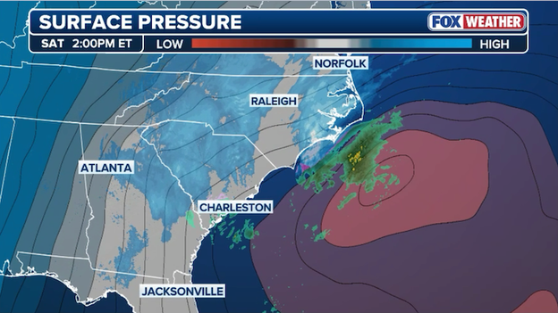
Radar and pressure analysis showing the nor'easter now rapidly intensifying over the Atlantic Ocean.
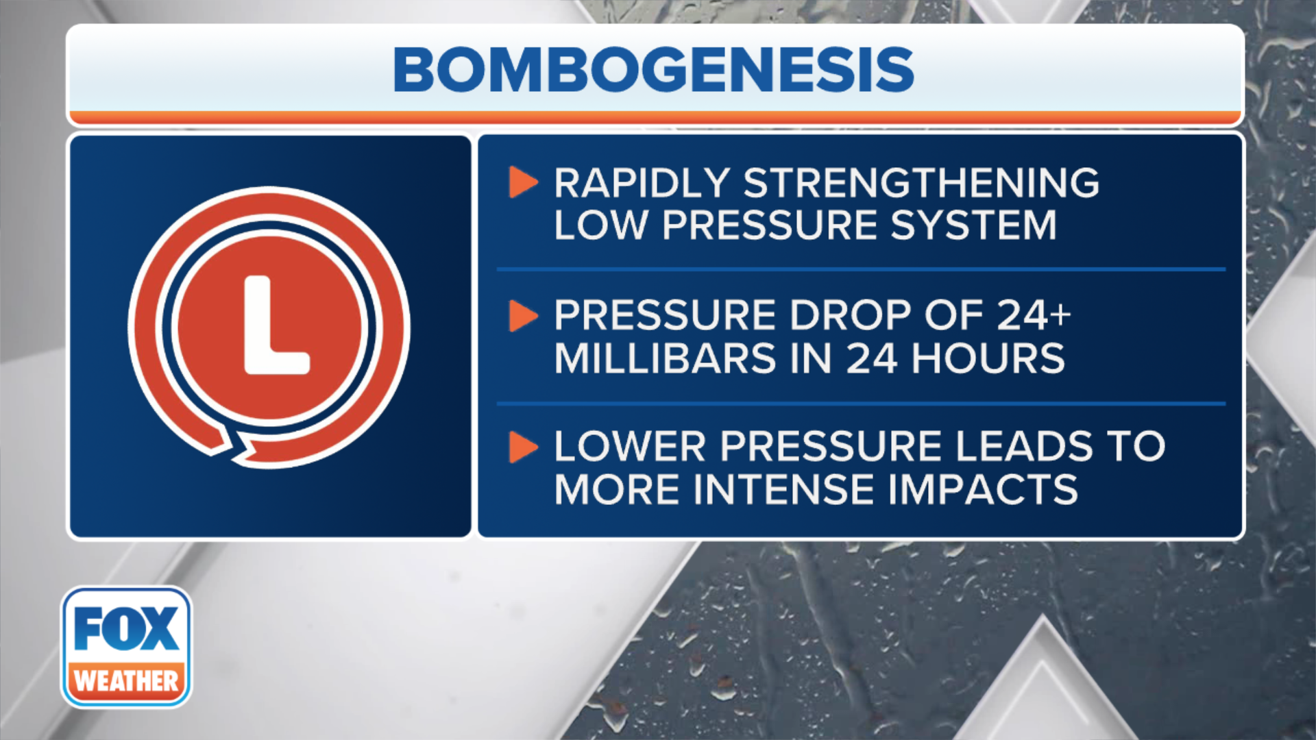
FOX Weather meteorologists say this weekend's nor'easter is now rapidly intensifying right on schedule. An area of low pressure is quickly strengthening off the coast of the Carolinas and is expected to undergo "bombogenesis" in the next 24 hours.
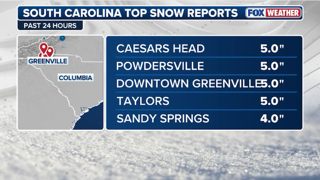
Top snow reports so far in South Carolina as of 2 p.m. ET Saturday.
An Air Force Reconnaissance C-130J just took off from its base in Biloxi, MS to fly into the nor'easter. It's goal is to sample the atmosphere in the from top to bottom ahead of the storm so that computer forecast models can get the most clear picture of how the storm is intensifying. The Hurricane Hunters often fly into major winter storms and atmospheric rivers to give forecasters better data that has been proven to improve forecasts.
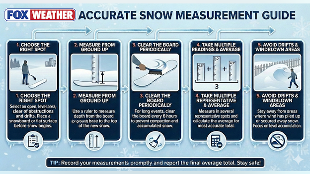
FOX Weather's guide to accurate snow measurement.
To get the most accurate snow total, skip the grass and find a flat, level surface away from buildings and wind-swept drifts. Use a sturdy ruler to measure straight down to the base, taking several samples across your yard to calculate a true average. For the best results during long storms, clear your "snow board" every six hours to prevent the weight of new flakes from compacting your totals.
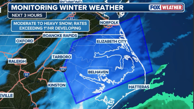
Radar showing where heavy snow could accumulate at more than 1"/hour in eastern North Carolina this afternoon.
The FOX Forecast Center says heavy snow is developing across eastern North Carolina this afternoon. Snow rates could reach 1" per hour from Elizabeth City to Belhaven in the hours ahead.

Hartsfield-Jackson Atlanta International Airport recorded a 59 mph wind gust on Saturday afternoon.

Radar showing flurries and very light snow moving into Tallahassee, Florida this afternoon.
The FOX Forecast Center says snow has reached as far south as Tallahassee, Florida this afternoon. Flurries are being reported in the city as arctic air surges south into the Sunshine State.
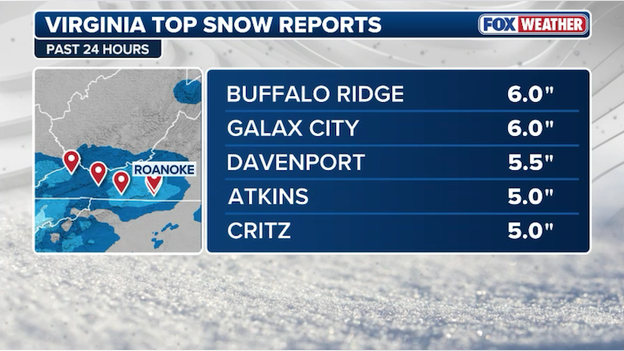
Top snow reports from Virginia as of 1:30 p.m. Saturday.
Top snow reports from North Georgia as of 1:30 p.m. ET Saturday.
Top snow reports so far from the major nor'easter slamming the Southeast.
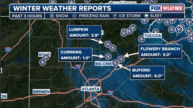
Winter weather reports showing the latest snow reports from around North Georgia.

An image from the South Carolina Department of Public Safety shows an overturned vehicle following a crash in snowy conditions.
South Carolina leaders are urging everyone to stay home as heavy snow creates treacherous travel conditions. In a post on X, the South Carolina Department of Public Safety says road conditions are deteriorating rapidly.
Folks, THIS is why we're asking you to stay home.
The department says it is seeing an increase of service calls for cars losing control and in ditches across a large portion of the Upstate, northern Midlands and Pee Dee.
Radar image showing the heavy snow falling across Upstate South Carolina.
Near-whiteout conditions are making for treacherous travel conditions in the Greenville-Spartanburg region of South Carolina. Weather observation sites in the area are reporting visibilities under one mile as snow rates reach exceed one inch per hour at times.
South Carolina Department of Transportation camera showing traffic at a standstill on Interstate 85 near Spartanburg.
A serious crash on I-85 North near the Greenville-Spartanburg corridor in South Carolina has brought traffic to a complete standstill as heavy snow continues to hammer the Upstate. Emergency crews are responding, and authorities are urging all motorists to avoid the area as conditions remain impassable.
In a post on X , Gwinnett County Police is urging everyone to stay off the roads. The agency says road conditions across Gwinnett County are "bad." Gwinnett County Police, Code Enforcement, DOT, and many other partners are working hard to address conditions; however, due to the current weather, Gwinnett County Police are strongly urging drivers to stay off the roads.
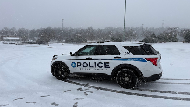
Gwinnett County Police squad car parked in snowy, icy conditions from a post on X.
It says officers are responding to a high number of crashes across the county, many involving multiple vehicles, due to the icy and hazardous conditions. And some roads are impassable at this time.

Gastonia Police Department photo from X post showing a car into a sign.
The Gastonia Police Department near Charlotte, North Carolina is urging drivers to stay off the road as snow hammers the area. In a post on X, GPD says there are icy spots leftover from last weekend's storm, now hidden under the snow from this weekend's storm. The post included an image of a car into a Food Lion sign, which the department says happened on South New Hope and Redbud. Fortunately, there were no injuries reported.
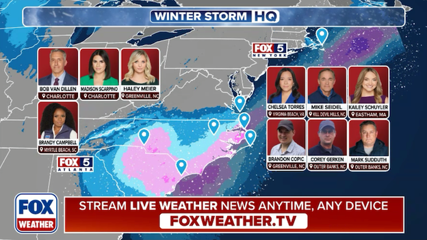
FOX Weather has deployed a team of meteorologists and correspondents along the East Coast for the nor'easter.
FOX Weather is providing LIVE, around-the-clock coverage of the nor'easter. With more than a dozen crews deployed into the storm, this is the place for the most comprehensive storm coverage. Our team of meteorologists and correspondents will be Weathering It Together with you, reporting on the latest LIVE developments as the storm unfolds.
Radar image showing light snow falling in North Florida.
The FOX Forecast Center says the powerful nor'easter and arctic air have combined to produce snow in the Sunshine State. Light snow and flurries in Marianna, Florida north of Interstate 10 in the state's panhandle.
In a post on X, Florida Governor Ron DeSantis wrote about the potential for "falling iguanas" in the Sunshine State as temperatures plummet this weekend.
These invasive reptiles need to “let us alone!"
According to the Florida Fish & Wildlife Conservation Commission, a new Executive Order allows people to remove the invasive reptiles from their property and take them to one of five designated FWC offices without a permit.
The FOX Forecast Center has increased snow projections for Charlotte, warning that the Queen City is bracing for a historic winter event. As a powerful nor'easter undergoes bombogenesis off the Atlantic coast, the metro area is now anticipating 5-8 inches of powdery, wind-driven snow through early Sunday. If these totals are realized, it will mark the most significant snowfall for Charlotte since the "monster" storm of February 26-27, 2004, which dumped nearly a foot of snow on the city.
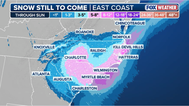
Latest snow forecast for the Carolinas showing 5-8 inches for the Charlotte, North Carolina area.
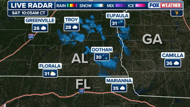
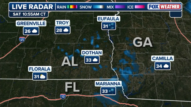
Radar showing flurries flying across southern Alabama as frigid air surges south.
Snow flurries are being reported as far south as Dothan, Alabama as a powerful surge of arctic air plunges deep into the Wiregrass region. While measurable accumulation is not expected, these rare flurries serve as a stark reminder of the frigid air mass that has sent temperatures across the Deep South surging 30-40 degrees below average.
A dangerous nor'easter is spinning into a bomb cyclone with heavy snow and powerful winds lashing the Southeast.
The intensifying nor’easter is currently undergoing a process called bombogenesis off the Carolina coast, with its central pressure dropping a staggering 35 to 40 millibars in just 24 hours. This "bomb cyclone" will blast the Southeast with hurricane-force gusts reaching 60 to 80 mph and heavy, wind-driven snow that could trigger blizzard conditions across the Outer Banks and coastal plains. Up to a foot of snow is expected alongside destructive waves and major coastal flooding. The storm’s rapid intensification has already forced three states into emergency declarations and disrupted over 10,000 U.S. flights, creating a rare and historic winter emergency for a region unaccustomed to such extreme conditions.
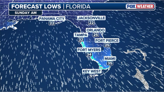
Low temperatures are expected to plummet into the 20s and 30s across Florida on Sunday.
The incoming arctic air mass is expected to bring the coldest temperatures to Central Florida since 2010, with a hard freeze forecast for three consecutive nights. Lows are predicted to dip into the 30s for South Florida's metro areas and reach the 20s near Lake Okeechobee, with wind chills potentially plunging as low as 9° to 20°F.
This extreme cold poses a severe risk to the state's agriculture, particularly for citrus growers who face crop damage if temperatures remain below 28°F for more than four hours. Winter vegetable crops like snap beans, sweet corn, and bell peppers are already reporting frost damage, including leaf burn and flower drop, which can lead to total field losses depending on the duration of exposure.
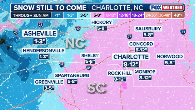
Latest snow forecast from FOX Weather showing 8-12 inches for Charlotte, North Carolina.
FOX Weather's latest snow forecast for Charlotte, North Carolina shows the Queen City could pick up as much as a foot of snow from the strengthening nor'easter. Snow totals can vary from neighborhood to neighborhood as microscale features impact the placement of heavier snow. The city is under a Winter Storm Warning as the snow continues to add up.
Radar image showing where 1"/hour snow rates are expected through the afternoon in North Carolina.
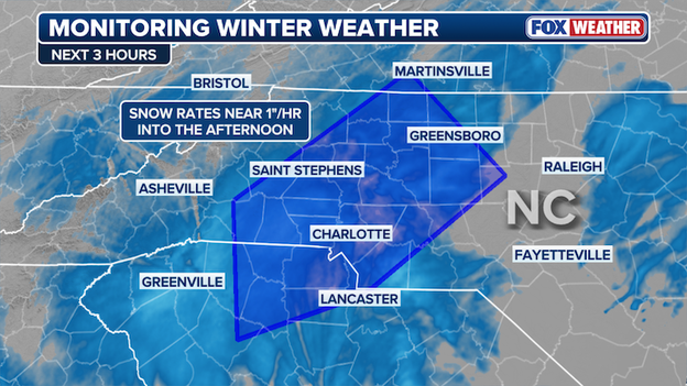
Heavy snow is hitting Charlotte, North Carolina right now and it's expected to add up quickly over the next few hours. The FOX Forecast Center says snow rates of 1 inch per hour are likely across the Carolina Piedmont area through the afternoon. As the snow piles up, road conditions are quickly worsening throughout the region.

FlightAware MiseryMap showing the travel headaches across the Southeast.
Flight tracking data shows that more than 10,000 U.S. flights have now been disrupted by the intensifying nor'easter, with impacts including both cancellations and significant delays. As the storm rapidly strengthens into a dangerous bomb cyclone, major airlines have proactively slashed their schedules to prioritize safety. Hard-hit hubs like Hartsfield-Jackson Atlanta International Airport (ATL) have seen hundreds of cancellations already this morning, while other critical coastal hubs like Charlotte (CLT) and Raleigh-Durham (RDU) face near-total shutdowns as heavy snow overwhelms ground operations.
Days after a historic ice storm crippled the Deep South, roughly 190,000 customers in Mississippi, Tennessee, and Louisiana remain without electricity as of Saturday morning, according to PowerOutage.com. The catastrophic event, which peaked a week ago with over one million nationwide outages, left a trail of broken power poles and snapped tree limbs across the region. In Mississippi alone, more than 70,000 residents are still in the dark, with some utility providers reporting that over half of their tracked customers are still awaiting restoration.
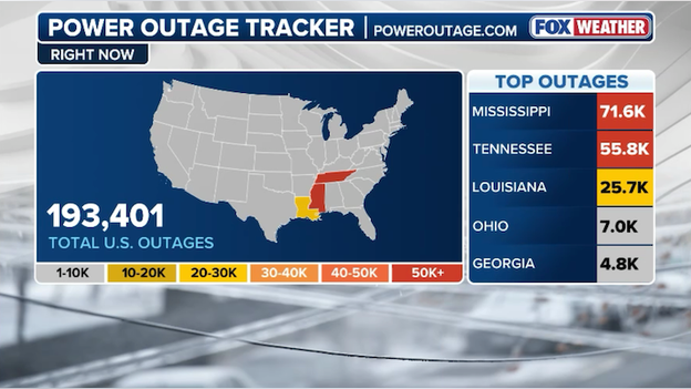
Latest power outage tracker shows widespread power outages across Louisiana, Mississippi, and Tennessee. (PowerOutage.com)
The slow recovery comes at a perilous time as a powerful nor'easter intensifies into a "bomb cyclone" off the Atlantic coast. While this new system is lashing the Carolinas and Virginia with hurricane-force gusts and heavy snow, it is simultaneously pulling a fresh blast of Arctic air into the South. For the thousands still without heat in Nashville and northern Mississippi, this deep freeze is expected to bring subzero wind chills through the weekend, complicating restoration efforts and prompting officials to open dozens of emergency warming centers.
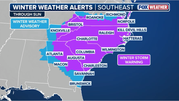
Winter Storm Warnings stretch from Virginia to Georgia as a powerful bomb cyclone blasts millions across the Southeast.
Right now, a nor'easter is rapidly intensifying off America's East Coast and will strengthen into a powerful bomb cyclone this weekend. As governors in South Carolina, North Carolina, and Georgia declare states of emergency, the storm's core is lashing the Carolinas with hurricane-force gusts and heavy snow. State leaders across the Southeast are telling people to stay home until conditions improve.
Weatherstem camera showing heavy snow falling in Charlotte, North Carolina.
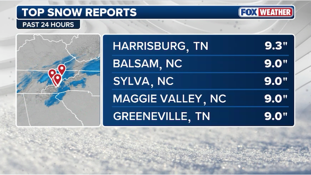
Latest top snow reports from this weekend's nor'easter.
Radar image showing snow falling across the Carolinas and southern Virginia.
Snow is becoming more widespread and heavier in response to low pressure forming off the Carolinas coast. As the nor'easter intensifies into Sunday, the snow will get heavier and wind speeds will continue to increase.
FOX Weather is often asked "do winter storms get names?" The answer is no.
The National Weather Service (NWS) and the National Oceanic and Atmospheric Administration (NOAA) do not recognize or use names given to winter storms by media outlets or private organizations in official forecasts.
The National Weather Service issues detailed forecasts and alerts to communicate specific impacts from winter storms, but we do not name them.
Unlike hurricanes, which are well-defined systems with a single clear center, winter storms are often broad, unorganized, and can have multiple centers that shift or redevelop. A single winter system can produce vastly different conditions across a region—such as a blizzard in one area and just rain in another—making a single name potentially misleading to the public.
The names you may have seen were developed without collaboration or consultation with official global weather authorities like the World Meteorological Organization (WMO) or the American Meteorological Society (AMS). Official agencies argue that naming winter storms is driven more by social media needs, such as creating hashtags, and marketing rather than sound meteorological science. The NWS has advised its forecast offices to avoid these names because they can create confusion, as the names are not used on official government warnings or safety bulletins.
In a statement to FOX Weather, the National Weather Service said, "The NWS will name tropical systems, but does not do this unilaterally - these names are from a list established by an international committee of the U.N. World Meteorological Organization.
Spokesperson Marissa Anderson told us, "This naming is contingent upon well defined and universal criteria (eg: an organized area of low pressure with top winds of at least 39 mph). Names are given to these systems because they are discrete and naming provides a common link as these storms traverse international boundaries and multiple languages, and to distinguish between multiple storms that may threaten a region concurrently. Unlike tropical systems, winter storms are more diverse with impacts that evolve throughout the storm’s life."
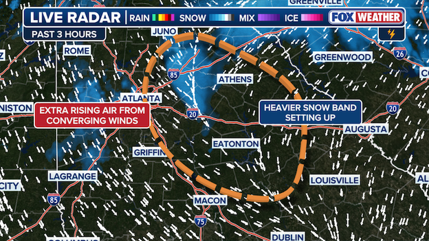
Radar analysis showing a convergence zone of winds producing heavier snow near the Atlanta metro area.
The FOX Forecast Center is tracking a band of heavier snow developing east of Atlanta, Georgia right now. Forecasters say it's an interesting setup, a convergence zone of northwest and northeast winds forcing air to rise more rapidly. This band is expected to lay down several inches of snow in the next few hours.
South Carolina Department of Transportation plow on Interstate 77. (@SCDOTpress X post)
The South Carolina Department of Transportation says its crews are working around the clock to clear roads from this weekend's nor'easter. With snow picking up in intensity, state leaders are asking everyone to stay off the roads and let the plows do their work.
With winds now whipping up along the North Carolina coast, flooding becomes a big concern for the people near the water. A Coastal Flood Warning is in effect for the Outer Banks and Hatteras Island where 2 to 4 feet of inundation above ground level is expected in low-lying areas near shorelines and tidal waterways. The warning is in effect through Sunday.
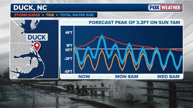
FOX Forecast Center says peak water rise could reach 3.2 feet in Duck, North Carolina early Sunday.
That water rise will increase the threat of property damage. Flooding is expected to extend inland from the waterfront threatening some homes and businesses. Numerous road closures and flooding of vehicles will be possible. Ocean overwash may lead to inundation of vulnerable portions of the coast, especially around times of high tides. And portions of Highway 12 could become inundated and impassable at times of high tides.
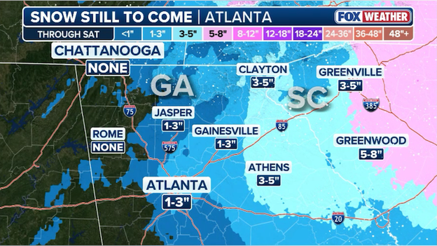
Latest snow forecast from FOX Weather showing significant snow across North Georgia.
The FOX Forecast Center is closely monitoring the snow falling across North Georgia right now. Computer forecast model guidance has trended forecast snow amounts upward in the last 24 hours, with up to 5 inches expected along the South Carolina border. Atlanta isn't missing out either - an inch or two of powdery snow is predicted to pile up in the metro area.
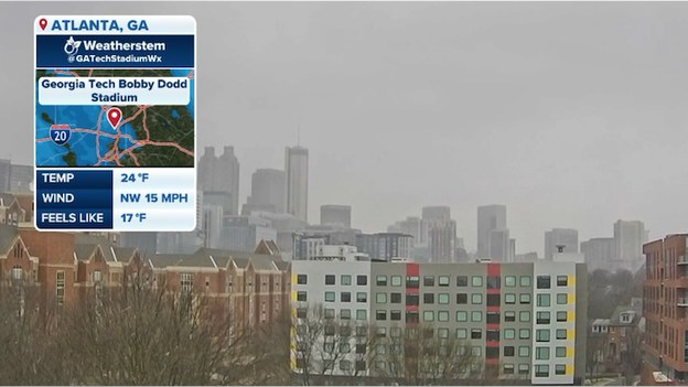
Weatherstem camera showing snowflakes falling in the Atlanta Metro area.
Most of North Georgia, including the Atlanta Metro area, is under a Winter Storm Warning as the powerful coastal storm sends snow flying across the Southeast. Weatherstem cameras in the Atlanta metro area show the snow falling with temperatures in the 20s. The snow is expected to add up quickly with the freezing temperatures throughout the region.
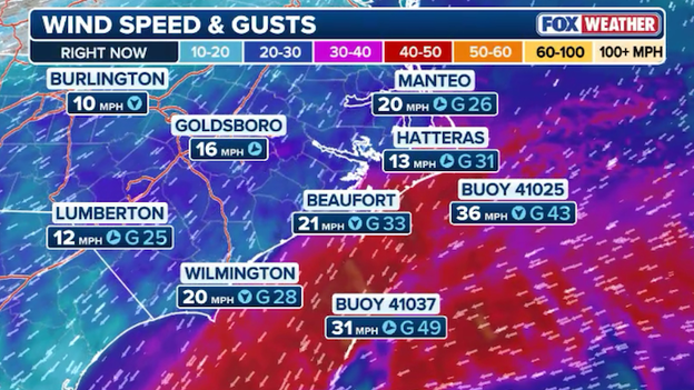
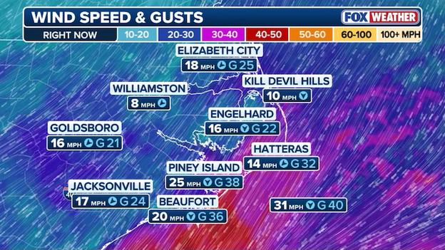
Wind speeds are steadily increasing along the coast of North and South Carolina this morning.
The storm is actively "bombing out" off the Carolina coast now with winds steadily increasing along the Carolinas coastline. FOX Weather meteorologists say hurricane-force gusts reaching 60 to 80 mph are possible as the storm undergoes rapid intensification today into tonight.
The nor'easter is severely disrupting U.S. air travel as it intensifies into a bomb cyclone off the Southeast coast. Data from FlightAware shows that over 9,400 U.S. flights are already delayed or canceled due to the storm's impact since Friday.
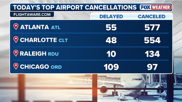
FlightAware reports more than 575 flights have been canceled at Hartsfield-Jackson Atlanta International Airport through Monday.
Major carriers are proactively slashing schedules to prioritize safety, with Delta Airlines cutting approximately 16% of its schedule at key hubs. Critical hubs such as Charlotte (CLT) and Raleigh-Durham (RDU) face near-total shutdowns this weekend as heavy snow overwhelms de-icing and snow removal capacities. Significant schedule adjustments are underway at Atlanta Hartsfield-Jackson (ATL), where even minor snow amounts can lead to major cancellations due to limited winter infrastructure.
Delta, American, Southwest, and United are just a few of the major airlines currently offering flexible travel waivers for dozens of cities, allowing passengers to rebook weekend flights without change fees or fare differences. Even after conditions improve, delays are expected to persist through Monday as airlines work to return aircraft and crews to their proper positions.
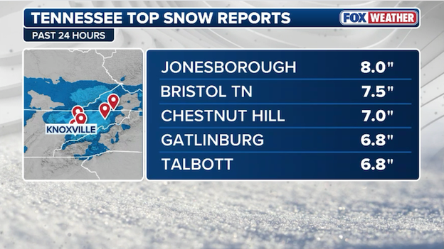
Latest top snow reports from Tennessee.
Weatherstem camera showing snow falling on the University of North Carolina-Chapel Hill campus.
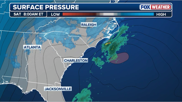
Analysis map showing pressures dropping along the Coast, indicating the nor'easter is forming.
The FOX Forecast Center says the nor'easter is developing right now. Analysis shows pressures dropping off the Carolinas coastline, a sign that low pressure is forming. As this intensifies rapidly in the hours ahead, the snow and wind will increase across the region.
It turns out that for Cape Cod, Massachusetts the "snow-pocalypse" is looking more like a "snow-maybe." While the Carolinas are getting buried, the forecast for the Cape has hit a snag.
The primary culprit for the shrinking snow totals is a classic offshore track shift. Nor'easters are notorious for being "games of miles," and this storm has decided to take a more easterly route than originally feared. The FOX Forecast Center says current data shows the storm center tracking farther out into the Atlantic. In the weather world, a shift of just 50 miles is the difference between "shoveling for hours" and "barely needing a broom."
And that's partly thanks to a stubborn area of dry high pressure over interior New England acting like a defensive wall. It’s pushing back against the storm’s moisture shield, keeping the heaviest snow bands suppressed to the south and east—leaving most of the Cape on the "wrong side" of the action.
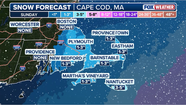
Latest snow forecast from FOX Weather showing 1-3 inches of snow for Cape Cod, Massachusetts.
While the snow totals are being downgraded, don't put away the winter gear just yet. Even if the snow "busts," the storm is still a bomb cyclone. This means wicked winds with gusts of 40–60 mph, which can feel just as intense without the snow. And the wind direction is shifting from North to Northwest, which will still push water into vulnerable eastern-facing shorelines during high tide.
Early Sunday morning, Tampa, Florida could witness rare light snow or flurries because of a staggering temperature contrast; while Gulf waters remain in the 60s, the air temperature at cloud level (roughly 5,000 feet up) is forecast to be nearly 40 degrees colder.
If these narrow bands of "Gulf-effect" precipitation move onshore while surface temperatures in Tampa hover near the freezing mark, the moisture will fall as snow before it has a chance to melt. While accumulation is not expected, any visible flakes would mark a historic event for a city that hasn't seen flakes fly in 16 years.
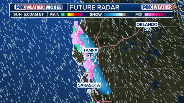
Exclusive FOX Weather Model showing a "Gulf-effect snow" rolling over Tampa, Florida early Sunday.
"Gulf-effect snow" is a rare meteorological phenomenon that mirrors the "lake-effect" snow common in the Great Lakes region. It occurs when a powerful arctic air mass surges southward over the relatively warm waters of the Gulf. As the freezing air passes over the water, it picks up heat and moisture, which rises rapidly to form narrow, intense bands of convective clouds. When the prevailing winds—steered by the nor'easter currently off the Atlantic coast—shift to the west or northwest, they push these moisture-laden bands inland toward the Florida peninsula.
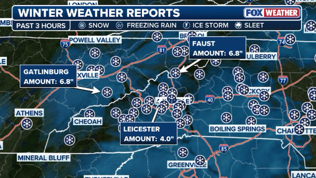
Winter weather reports showing 6.8" of snow recorded in Gatlinburg, Tennessee.
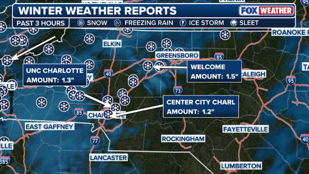
Winter weather reports showing 1.2" of snow recorded so far in Charlotte, North Carolina.
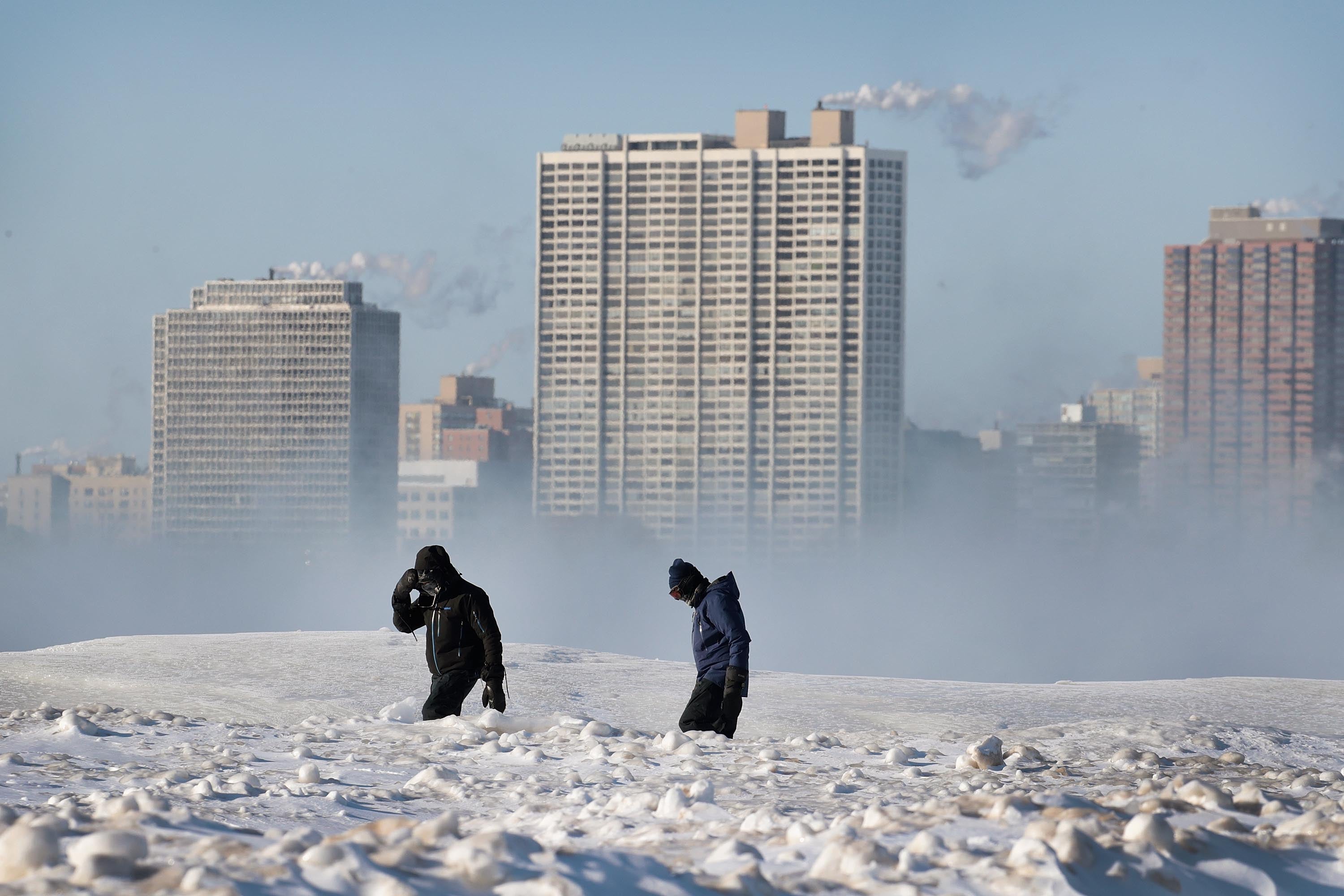
A historic arctic blast is currently gripping the eastern United States, with a lobe of the polar vortex pushing dangerously cold temperatures as far south as Florida. More than 185 million Americans are waking up under some type of cold weather alert.
Dangerously low wind chills, expected to dip between -5°F and -10°F across the Mid-Atlantic and Southeast, have prompted widespread Extreme Cold Warnings and Cold Weather Advisories through the weekend. This record-setting "deep freeze" is not only challenging century-old daily lows in cities like Pittsburgh and Miami but also threatens to keep major metros like New York, Washington, and Philadelphia below freezing for over a week—one of the longest such stretches in decades.
Radar image showing snow increasing in intensity and coverage across eastern North Carolina.
The FOX Forecast Center is tracking the snow increasing across eastern North Carolina and the Outer Banks right now. Radar shows the snow picking up in coverage and intensity this morning as the nor'easter develops.
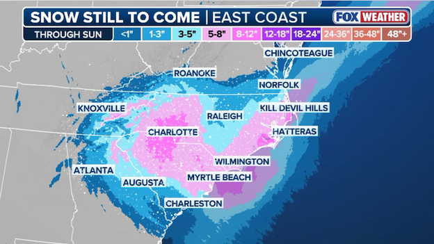
Latest snow forecast from FOX Weather showing up to a foot of snow falling across the Carolinas.
The FOX Forecast Center says this weekend's nor'easter remains on track to dump heavy snow across the Carolinas. Up to a foot of snow could fall in portions of the Southeast as a powerful nor'easter bombs out along the East Coast of the U.S.
One notable change this morning: a drop in snow amounts across central North Carolina. Forecasters say a "dry slot" will reduce the snow in this part of the Carolinas. Raleigh, North Carolina may end up with just a few inches of snow, while places to the west and east pick up significantly more.
NASA has decided to delay the launch of Artemis II as dangerously cold air invades the Sunshine State. According to the agency's website, NASA is targeting Monday, February 2, as the tanking day for the upcoming Artemis II wet dress rehearsal at the agency’s Kennedy Space Center in Florida. This pushes the first potential opportunity to launch to no earlier than Sunday, February 8.
Managers have assessed hardware capabilities against the projected forecast given the rare arctic outbreak affecting the state and decided to change the timeline.
NASA says a launch date will be set pending the outcome of the dress rehearsal. Originally, Saturday, February 6 and Sunday, February 7 were considered viable opportunities for launch.
Right now, the Artemis II crew remains in quarantine in Houston and NASA says managers are assessing the timeline for crew arrival.
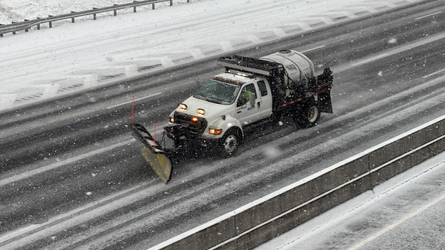
The North Carolina Department of Transportation says it is ready to tackle whatever Mother Nature brings this weekend. In a post on X, it reminded residents that plows operate on scheduled, priority-based routes.
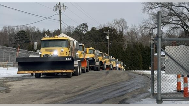
North Carolina Department of Transportation plows are ready for this weekend's nor'easter.
They're also reminding North Carolinians that if sustained wind speeds reach 35 mph or greater, their plows cannot operate. The FOX Forecast Center says wind speeds up to 70 mph are expected in eastern North Carolina late Saturday into Sunday, which could suspend plowing efforts.
While this weekend's nor'easter is poised to bring widespread heavy snow to the Southeast, a specific meteorological phenomenon known as a dry slot could leave Raleigh and central North Carolina with significantly lower totals than neighboring regions.
A dry slot is a region of clear, dry air that is pulled into a strengthening low-pressure system from the mid-to-upper levels of the atmosphere. In a nor'easter, this dry air typically originates from the southwest and wraps around the southern and eastern sides of the storm's center.
High-Resolution Rapid Refresh Model (HRRR) showing a dry slot over North Carolina on Saturday. (Source: WeatherBELL)
When this dry air infiltrates the system, it acts like a wedge, evaporating moisture before it can reach the ground as snow. If the dry slot positions itself directly over the Triangle, it would essentially shut off the snow engine, "busting" the snow original snow forecast for this area.
The only factor that could save Raleigh's snow totals is if the upper-level trough remains sharp enough to force the moisture to wrap further inland, filling in the dry slot. However, as of Saturday morning, the trend in high-resolution modeling favors the dry air intrusion as the storm moves into its most intense phase.
Wind speeds are steadily increasing across the Carolinas as the nor'easter intensifies off the coast.
The FOX Forecast Center says the nor'easter has begun its rapid intensification off the Southeast coast. Wind speeds are steadily increasing across North and South Carolina this morning. Right now, sustained winds range from 10-25 mph along the coast with gusts nearing 40 mph.
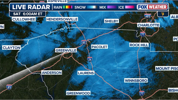
Radar image showing light snow falling around Greenville, South Carolina.
Light snow is falling across central and western South Carolina right now. That snow is starting to add up and will make roads slick as the morning progresses.
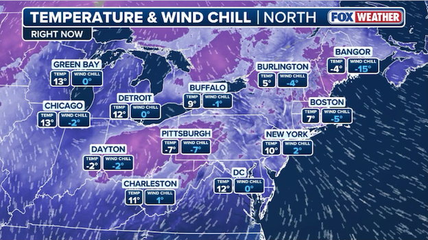
Temperatures are in the 10s and single digits across the Northeast and Great Lakes.
Millions of Americans are waking up to life-threatening cold air this morning. Air temperatures are in the single digits and teens across the Northeast and Great Lakes, while wind chills are near 0°F. Exposure to this extreme cold can result in hypothermia and frostbite within 30 minutes.
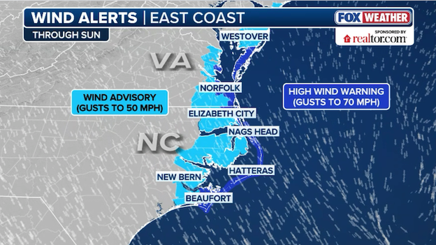
High Wind Warnings and Wind Advisories are in effect along the coast from Delaware to North Carolina.
Forecasters say this weekend's nor'easter will pack a punch when it comes to wind. The storm system responsible for all the snow in the Southeast will rapidly intensify over the Atlantic Ocean in the hours ahead. This rapid strengthening will produce powerful winds, particularly at the coast. High Wind Warnings and Wind Advisories are up for coastal Virginia and North Carolina. Occasional wind gusts to 70 mph are expected, but the FOX Forecast Center says hurricane-force wind gusts to 75 mph are likely, too.
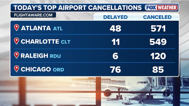
FlightAware reports more than 550 flights have been disrupted at Atlanta's Hartsfield-Jackson International Airport.
For the second weekend in a row, U.S. airlines are being forced to cancel hundreds of flights due to wintry weather. This weekend's nor'easter will dump heavy snow on the Carolinas and as far south as Atlanta, home to one of the world's busiest airports. Data from FlightAware shows more than 570 flights have been canceled at Hartsfield-Jackson Atlanta International Airport so far today. In total, more than 8,500 U.S. flights have been disrupted (delayed or canceled) since Friday.
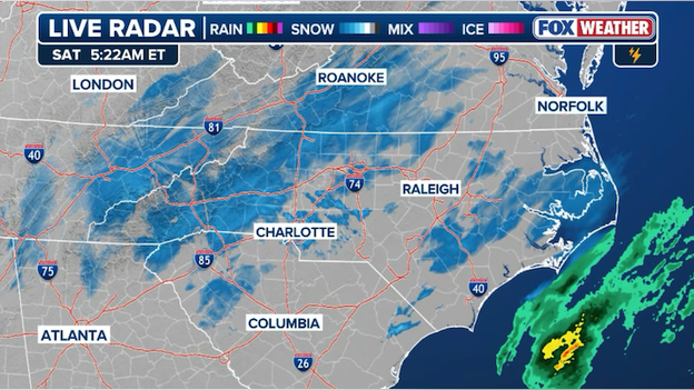
Latest radar image showing light snow starting to develop across North Carolina.
Radar reveals snow starting to break out across North Carolina. Most of this is light snow, but the intensity will pick up through the morning as the nor'easter gets going off the coast.
You can go back and see how the forecast has evolved with live updates from Friday's coverage.
Click here to see the minute-by-minute updates from FOX Weather.
You’ve reached the beginning of this live coverage.