Live updates: More snow wrecks morning commute in the Northeast as millions dig out from blizzard
Live updates: More snow wrecks morning commute in the Northeast as millions dig out from blizzard
Download the AppLIVE Winter Storm HQ coverage continues from FOX Weather
View postCoverage for this event has ended.
FOX Weather is your Winter Storm HQ, providing around-the-clock live coverage to help keep your family safe.
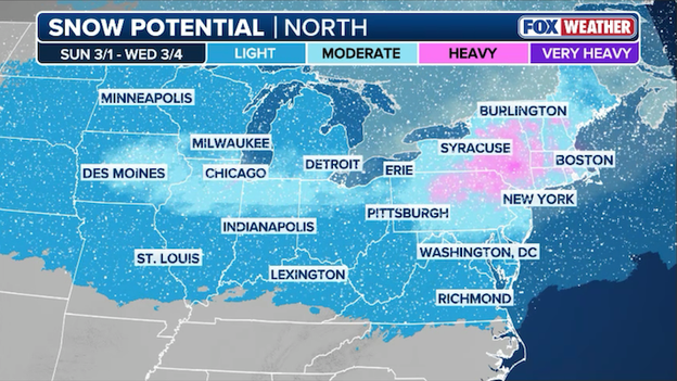
Computer forecast models are showing a moderate-to-heavy snowstorm from the Midwest to the Northeast through early next week.
As the Northeast digs out from the Blizzard of 2026, the FOX Forecast Center is already tracking a complex winter storm slated to arrive as March kicks off. While the threat of a major event is far from negligible, meteorologists are highlighting several atmospheric hurdles that make this particular forecast a significant challenge.
The primary difficulty lies in the interaction between a shot of cold air moving across the northern tier on Saturday and a disturbance ejecting from the Rockies on Sunday.
Because this system is pulling in humid, warmer air from the south, a process called "overrunning" will occur as that moisture glides over the dense cold air near the surface.
The biggest wildcard for snow totals remains the transition line where cold air meets warm moisture. Forecast models are currently grappling with the depth of the cold air mass; if the layer of freezing air is too shallow, many major cities could see snow transition into sleet, freezing rain, or plain rain.
This mixing is a major concern along the I-70 corridor and the Ohio River Valley, where the threat of a disruptive ice storm is highest, based on current data.
Even slight shifts in the jet stream's position could determine whether a city like New York or Philadelphia sees a half-foot of fresh powder or a messy, slushy mix that cuts down accumulation but increases the risk of power outages from ice-heavy lines.
The FOX Forecast Center is closely monitoring three specific factors that will decide the storm's ultimate impact:
- Rockies energy: The amount of energy that successfully ejects from the Western trough will dictate the overall strength and moisture content of the storm. Think of the energy coming out of the Rockies as the engine of the storm. Meteorologists are watching to see how much fuel (energy and moisture) this system picks up as it moves toward the East. If the storm emerges from the mountains with a lot of energy, it will be stronger and capable of carrying much more moisture. However, if that energy stays trapped out West or peters out, we could end up with a much weaker, less impactful system.
- Jet stream positioning: If the jet stream dip over the Northeast holds firm, it could block Pacific moisture from reaching the coast, resulting in a much weaker system. The jet stream is like a high-altitude river of air that steers weather systems. Currently, there is a dip in that river sitting over the Northeast. If that dip stays strong and rigid, it can act like a defensive wall, blocking the moisture coming from the Pacific and the Rockies from reaching our coast. If that wall holds, the storm could be pushed out to sea or fizzle before it hits, but if it shifts or weakens, the door opens for a major snow event.
- Temperature depth: Meteorologists are tracking whether the "cold dome" over the Great Lakes and Northeast is deep enough to prevent rain from infiltrating the snow bands. For it to snow, it doesn't just need to be cold on the ground; it needs to be cold all the way up through the atmosphere. Meteorologists call this the cold dome. As warm, humid air tries to push north, it will ride up over this dome of cold, heavy air. If that cold air is deep (meaning it extends from the ground all the way up to the clouds), the precipitation stays as snow. If the cold air is too shallow or thin, the warm air can melt the snow into rain or sleet before it hits the ground, which is how we end up with a slushy mess instead of a winter wonderland.

For now, everyone from the Midwest to New England should be closely monitoring the forecast as forecasters fine tune where the heaviest snow and ice will fall.
A new snow report from Shelton, Connecticut, reveals 2.5 inches of fresh accumulation has fallen as this morning's clipper system moves through Fairfield County.
This quick burst of snow is adding another layer of difficulty for local crews who are still working to clear the massive drifts left behind by the recent blizzard.
Now that the snow has ended, New York City's Central Park has officially recorded 1.4 inches of fresh snow from this morning's quick-hitting clipper system.
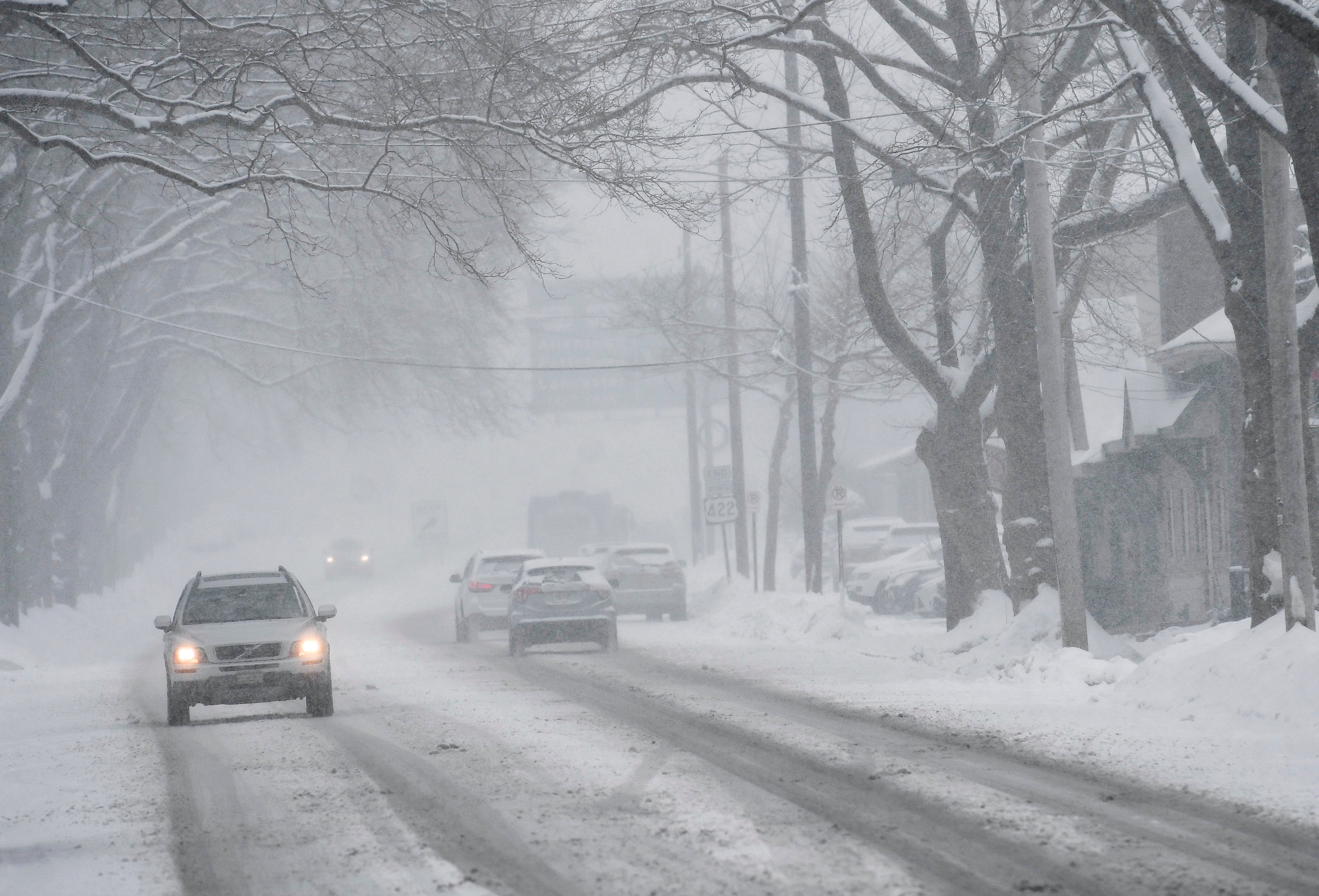
A fresh coating of snow from a quick-hitting clipper system has transformed the Tri-State area’s morning commute into a hazardous obstacle course.
From Connecticut to New Jersey, state police and local authorities are responding to dozens of incidents as vehicles struggle with untreated, icy surfaces and visibility that has dropped to 1/4 mile or less.

Screenshot of 511NY traffic map showing numerous crashes and incidents across the NYC Tri-State area Wednesday morning.
Numerous crashes and slideoffs have been reported from Connecticut to New Jersey, bringing the already-slow commute to a halt.
While road crews pretreated most roads and highways ahead of the first flake, the intense snow that hit just before 7 a.m. ET overwhelmed the best snow-fighting equipment.
Even in areas where snow has tapered off, like New York City and Northeast New Jersey, officials warn that lower level snow-fighting operations are ongoing as more than 700 salt spreaders battle slick patches of ice.
A fresh snow report from a National Weather Service weather observer in Blenheim, New York, confirms that 3.0 inches of snow has fallen this morning.
A new snow report from Armonk, New York, confirms the quick-hitting clipper system packed a punch.
2.5 inches of fresh snow was reported by a trained spotter as this morning's quick-moving system swept through Westchester County.
This localized total is slightly higher than the 1.2 inches recorded in Central Park, further complicating cleanup efforts for northern suburbs still recovering from the recent blizzard.
As of 7 a.m. ET, New York City's Central Park has officially recorded 1.2 inches of fresh snow from this morning's quick-hitting clipper system.
While this total is modest compared to the recent blizzard, it marks yet another layer of accumulation for a city still in the middle of a massive recovery effort.
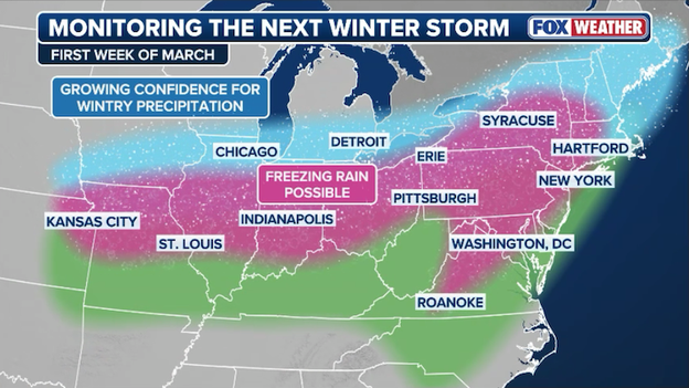
FOX Weather meteorologists are monitoring a winter storm that could deliver snow, freezing rain, and ice to millions in the first week of March.
A powerful new winter storm is set to roar into the Northeast just as March begins, potentially burying the region under fresh layers of snow while millions are still digging out from the Blizzard of 2026.
The setup kicks off this Saturday as a blast of cold air takes hold of the northern third of the country, setting the stage for a moisture-heavy disturbance rolling in from the Rockies on Sunday.
As warm, humid air is funneled north, it will override the dense cold air in place—a process known as "overrunning"—creating a messy shield of snow, sleet, and freezing rain across the Mississippi Valley, the Great Lakes, and eventually the Northeast.
While major cities like Chicago, Cleveland, and Pittsburgh could see impacts as early as Sunday, the storm is expected to track toward Philadelphia, New York, and Boston shortly after.
Meteorologists at the FOX Forecast Center warn that while the threat of a significant storm is clear, the exact magnitude remains a work in progress. The severity of the impacts will depend on how much Pacific energy makes it east and how strongly the jet stream holds over the Northeast, but with the current data, the risk of a major winter event is far from negligible.
See the Blizzard of 2026 recovery with FOX Weather's LIVE Winter Storm HQ coverage from Tuesday.
Restoration efforts are facing another hurdle this morning as a fresh coating of snow sweeps across a region already struggling with widespread power failures.
According to the latest data from PowerOutage.com, over 215,000 customers remain without electricity as of Wednesday morning.
While utility crews have made significant progress since the height of the blizzard, the arrival of this new clipper system—bringing an additional 1 to 3 inches of snow—is complicating the final push to get everyone back online.
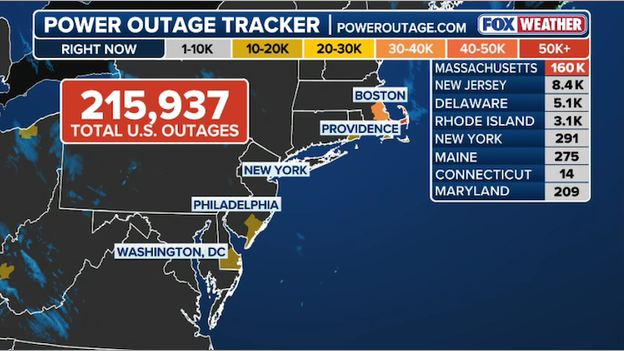
Latest power outage tracker showing more than 215,000 customers without power across the Northeast.
The burden of these outages continues to fall most heavily on Massachusetts, where a staggering 160,000 customers are still waiting for the lights to come back on. Other states in the region are also seeing persistent issues, including New Jersey with over 8,400 outages and Delaware with approximately 5,100.
With temperatures remaining below freezing, local authorities are urging those without heat to seek out warming centers as crews battle the new snow and icy conditions to reach damaged lines.
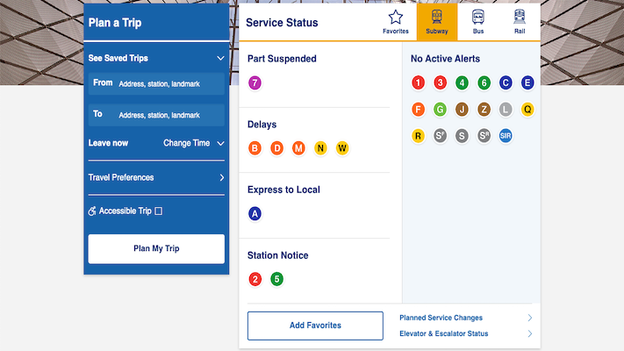
MTA website showing multiple delays and service changes as the system recovers from the Blizzard of 2026.
The MTA is still locked in a high-stakes cleanup following the Blizzard of 2026, and while most lines are moving, your ride to work might feel a little different today.
To keep the system safe while crews clear lingering ice and monitor frozen switches, the agency is currently running A and D trains express-to-local in several sections.
Transit leaders say these service changes are essential for protecting the equipment on outdoor tracks that were buried under nearly 20 inches of snow earlier this week.
While the city braces for a secondary "clipper" system today, de-icing trains and "Darth Vader" snow-fighting equipment are circling the tracks to prevent new buildup.
If you're heading to the platform, check the MTA app frequently—service patterns are shifting by the hour as the massive recovery continues.
A quick-hitting burst of snow is moving through the Northeast this morning, and while it isn't another monster blizzard, it’s packing enough punch to catch drivers off guard.
The FOX Forecast Center warns that these bands can drop visibility to 1/4 mile or less in an instant, making for a treacherous finish to the morning commute.
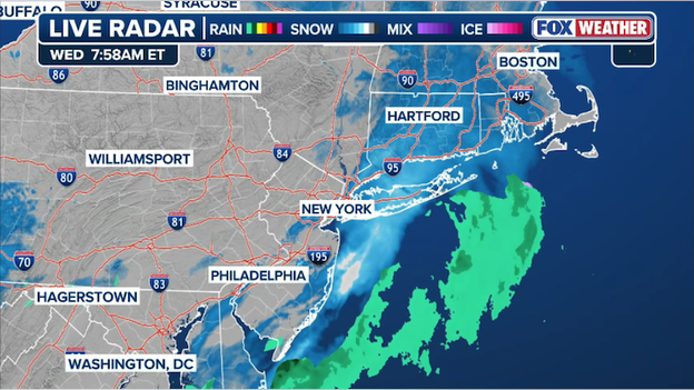
Radar showing widespread snow throughout the Northeast now shifting east of New York City.
The bulk of the system is expected to leave behind a fresh 1 to 2 inches of accumulation, though a few lucky (or unlucky) spots could see up to 3 inches before the clouds clear.
If you're in Northeast New Jersey, the Lower Hudson Valley, or New York City, the worst of the moderate-to-heavy snow has already pushed to your east.
The focus now shifts toward Long Island and Southern New England, where this quick-hitting snow is on the move.
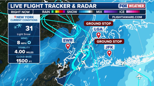
Ground stops were ordered for major New York City airports this morning due to the quick-hitting snow.
Just as the Northeast began its massive dig-out from the Blizzard of 2026, a quick-hitting clipper system has triggered fresh ground stops at New York’s major hubs.
This morning, the Federal Aviation Administration (FAA) ordered ground stops for both John F. Kennedy International Airport (J.F.K.) and LaGuardia Airport (L.G.A.) as new snow and icy conditions hampered efforts to clear runways.
For travelers, a ground stop means that flights destined for an affected airport are temporarily prohibited from taking off, essentially hitting "pause" on air traffic to prevent overcrowding or safety issues at the destination. Even if the weather is perfectly clear where you are, you may be held at your departure gate or on the tarmac because the destination airport lacks the runway capacity or gate space to safely handle your arrival.
Travelers are facing a difficult morning as these operational pauses compound the already historic backlog of more than 11,000 regional flight cancellations since Sunday.
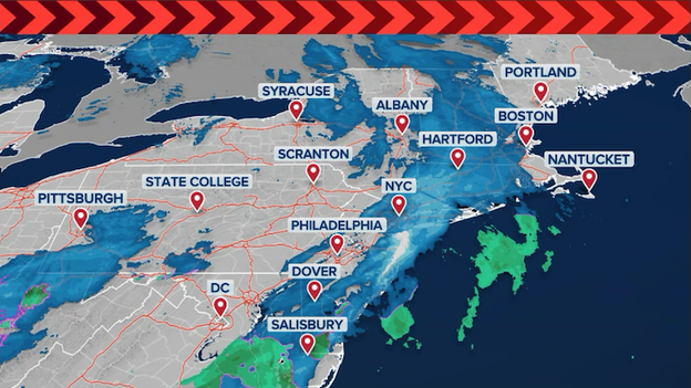
A quick-hitting clipper is dropping snow on the Northeast as millions commute to work and school.
- Commuter chaos returns – A fast-moving Alberta Clipper is dropping a fresh 1 to 3 inches of snow across the Northeast this morning, creating slick roads and compounding travel issues for millions still digging out from the historic blizzard.
- Power crisis lingers – Approximately 200,000 customers remain without power across the region. Massachusetts is the hardest hit with roughly 160,000 outages, particularly on Cape Cod where restoration may not be complete until Friday.
- Flights halted – Ground Stops have been ordered at New York's LaGuardia and JFK Airports as a fresh coating of snow slows down operations.
- Schools reopening – Most major districts are attempting to return to normalcy today, with Boston Public Schools reopening for the first time since the storm. New York City schools remain open for a second day despite ongoing "unplowed street" complaints, especially on Staten Island.
You’ve reached the beginning of this live coverage.