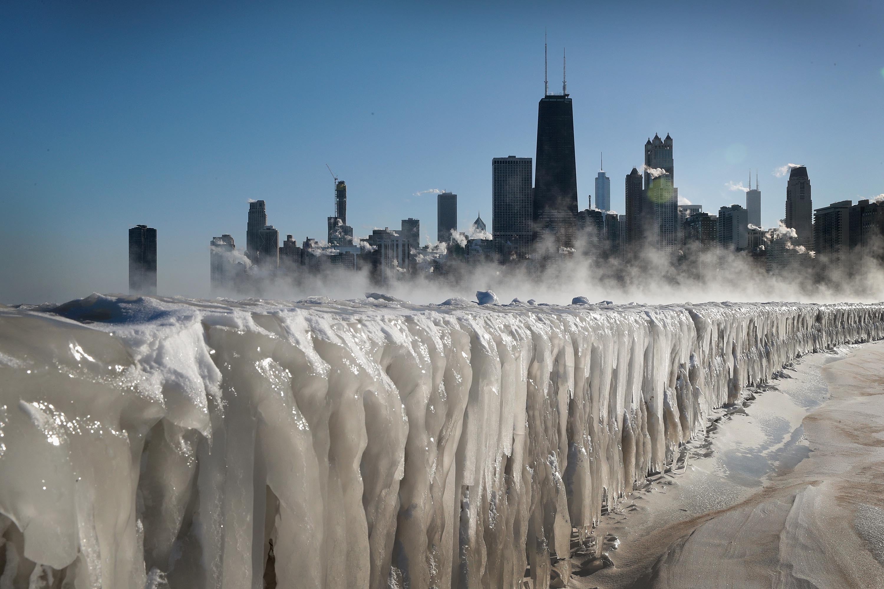
Live updates: New snowstorm targets Northeast as blizzard cleanup continues, thousands without power
Live updates: New snowstorm targets Northeast as blizzard cleanup continues, thousands without power
Download the AppLIVE Winter Storm HQ coverage continues from FOX Weather
View postCoverage for this event has ended.
FOX Weather is your Winter Storm HQ, providing around-the-clock live coverage to help keep your family safe.
The National Fire in Southwest Florida has resulted in the partial closure of Interstate-75, as dense smoke has created dangerous driving conditions.
The National Fire reached 25,000 acres in Big Cypress National Forest near Naples amid bone-dry conditions on Tuesday, according to the National Weather Service (NWS).
Rhode Island Governor took to X to share his thanks to the state of Pennsylvania, honorably mentioning Punxsutawney Phil and his prolonged winter prediction, for providing snow-removal after the historic blizzard slammed the Northeast.
After a request for assistance through the national Emergency Management Assistance Compact, Pennsylvania Governor Josh Shapiro and PennDOT responded to the call.
PennDOT sent over 30 pieces of equipment and associated operators, mechanics, foremen, and managers from its Harrisburg, Clearfield, Indiana, and Uniontown based regions to Rhode Island to assist in snow-removal efforts, the Governors Office announced in a press release.
“We’ve had historic winter storms in the Northeast this year, and Pennsylvania is proud to lend a helping hand to our friends in Rhode Island as they continue their recovery from the most recent snowfall,” said Governor Shapiro.
After completing work in Pennsylvania, PennDOT crews traveled to Rhode Island Wednesday to assist in some of the areas hit hardest by the monster nor'easter that slammed the region.
“Governors understand how complicated an emergency response can be—and they are often the first to step up and help other states in need,” said Rhode Island Governor Dan McKee.
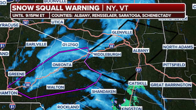
Over one million people fall under these Snow Squall Warnings.
Snow Squall Warnings are in effect for parts of New York and Vermont until 9:15 p.m.
The FOX Forecast Center said the squalls are moving east at 35 mph. Winds can reach up to 35 mph and visibility in the area is down to a quarter of a mile.
The warnings are in effect for Albany, Rensselaer, Saratoga and Schenectady counties.
There are nearly 900 flight delays and a handful of cancellations at Denver International Airport today as the area experiences strong winds.
The FOX Forecast Center said winds gusted over 50 mph near the airport around 12:50 p.m. MST, and gusts have consistently stayed in the 30 mph range all day.
The airport said the Federal Aviation Administration (FAA) has implemented a ground delay program for arriving flights.
Travelers are being advised to check with their airlines for the latest flight status before heading to the airport.
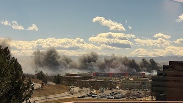
A grass fire breaks out near a high school in Thornton, Colorado.
Four firefighters and one civilian were injured in a grass fire that erupted in Thornton, Colorado, this afternoon, according to officials.
A high school right next to the fire was evacuated, and the blaze temporarily closed a major highway outside Denver.
Residents in the area were also evacuated. The fire has since been contained.
Officials said the injuries are non-life-threatening.
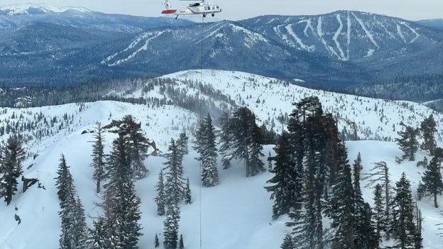
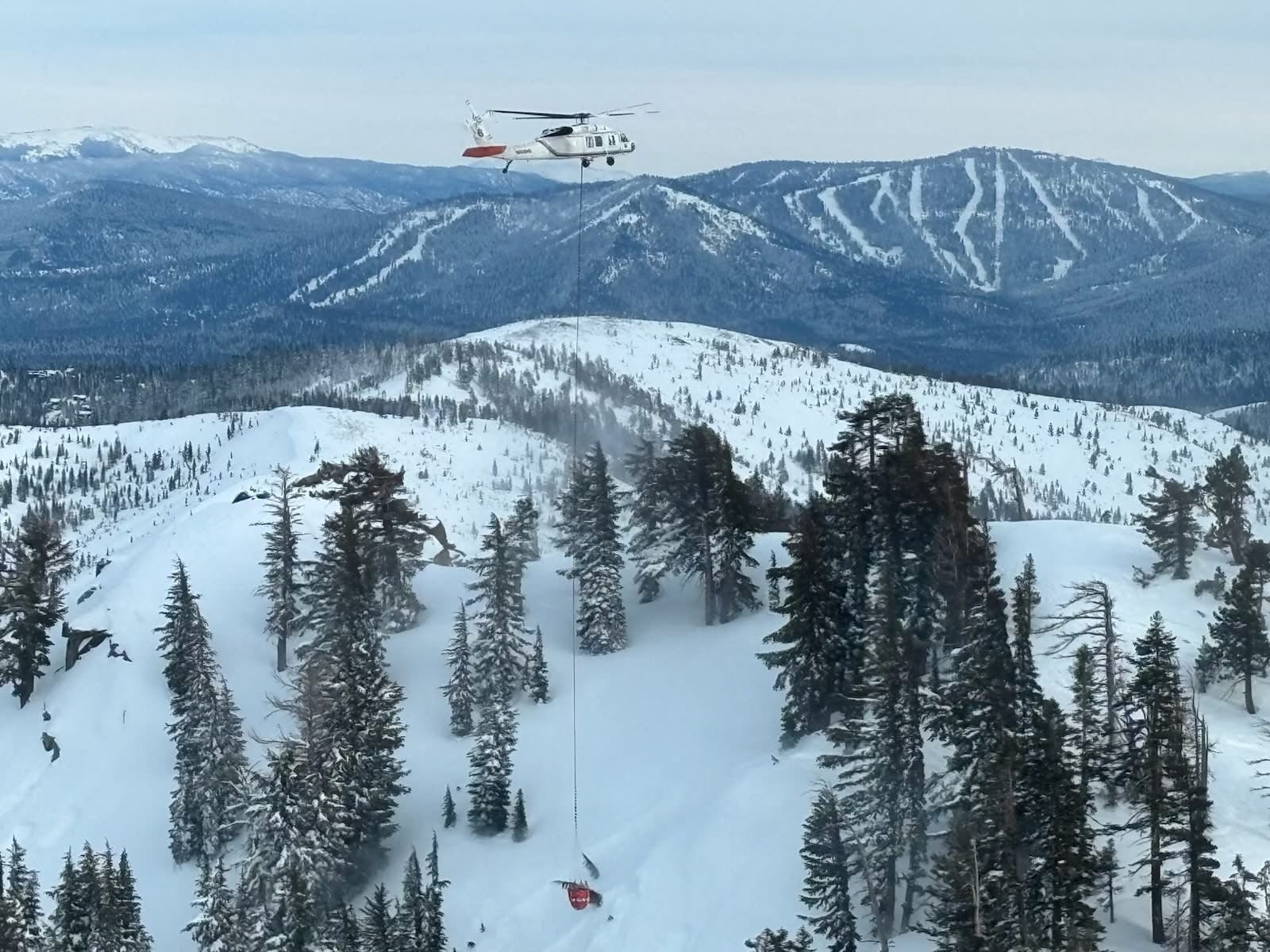
Crews conduct a rescue following a deadly avalanche that happened on Tuesday, Feb. 17, 2026.
A new report is giving insight into the deadly avalanche that claimed the lives of nine people in the Sierra Nevada last week.
Authorities initially said that eight skiers were killed during the historic avalanche on Castle Peak, but the Sierra Avalanche Center confirmed that a ninth person reported missing was found dead a few days later.
The ninth skier was found buried in the snow prior to nightfall on Friday, Feb. 20, the avalanche center said.
Rescue operations concluded on Saturday, Feb. 21, once the final four skiers' bodies were recovered.
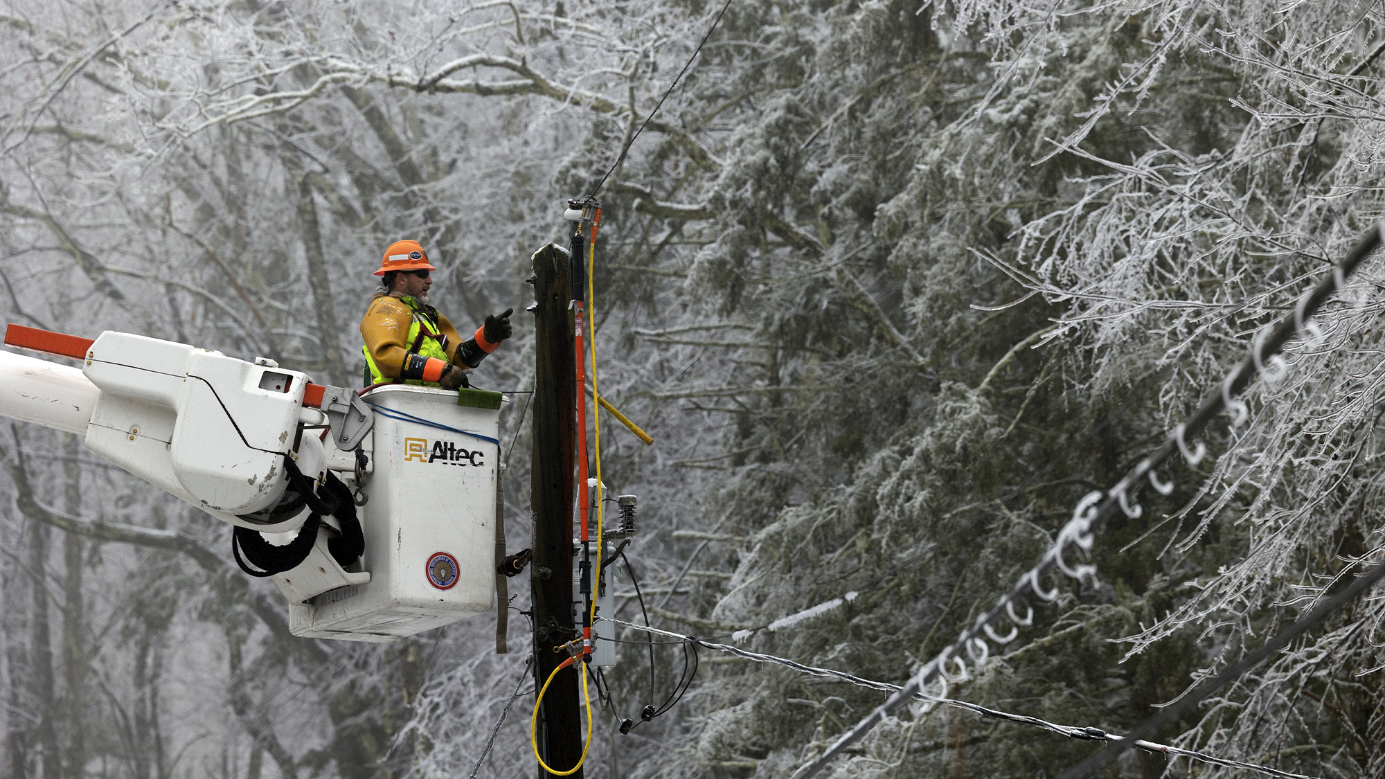
The power company, Eversource, said they've restored electricity to more than 295,000 customers in Massachusetts since the snowstorm this weekend.
"Our crews are continuing to work nonstop to assess and repair difficult-to-access damage in our hardest-hit communities," they said on social media.
More than 130,000 households remain without power in Massachusetts, with a majority of those outages being in Cape Cod, according to poweroutage.us.
A timeline for restoration can be found on Eversource's website.
Providence police said a citywide parking ban remains in effect following the historic blizzard.
The police department said they are actively ticketing and towing vehicles that are interfering with plow operations and delaying snow removal.
One of the biggest records broken during the snowstorm that slammed the Northeast is in Providence, which has recorded its biggest snowstorm of all time.
The city recorded a whopping 37.9 inches of heavy snow during the event.
"If you can stay off the roads, please do so. Keeping streets clear allows plow crews to work safely and helps emergency responders reach those who need assistance," police said on social media.
While the Eastern U.S. continues to dig out from record-breaking snow, a different kind of weather threat is emerging across the Central Plains this evening.
FOX Weather meteorologists are tracking a weak disturbance sliding through the region that could spark a few isolated, gusty thunderstorms across portions of Nebraska and Kansas through sunset.
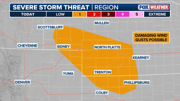
A few strong or severe thunderstorms are possible across portions of Nebraska, Kansas, and Colorado through this evening.
Even though these storms aren't expected to be widespread or traditionally severe, they are capable of producing localized damaging wind gusts between up to 60 mph. Because the lower levels of the atmosphere are quite dry, much of the rain may evaporate before hitting the ground (a phenomenon known as virga), but the resulting cooling can accelerate wind toward the surface with surprising force.
Even a weakening shower could kick up a sudden, strong gust—enough to toss loose patio furniture or create a hazard for high-profile vehicles on east-west routes like I-80.
And these gusty winds are overlapping with low humidity (around 25%), keeping fire weather conditions elevated across western Kansas and southwestern Nebraska until the front fully passes.
Commuters across the interior Northeast are being urged to stay weather-aware this afternoon as a quick-moving cold front threatens to trigger a series of intense snow squalls during the drive home.
These localized bursts of heavy snow are notorious for causing "instant winter" conditions, often dropping visibility to near zero and turning dry pavement into a sheet of ice in a matter of seconds.
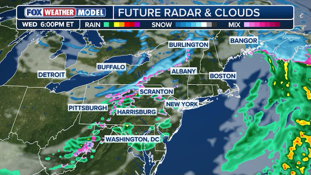
Exclusive FOX Weather Model showing snow squalls sliding east across the interior Northeast this evening.
The FOX Forecast Center has highlighted a particular risk for a flash freeze as temperatures plummet behind the front. Any wet surfaces from this morning's light snow or this evening's squalls will quickly refreeze, making braking almost impossible for those caught in the squalls.
Unlike a steady snowstorm, these squalls are brief—often lasting less than 30 minutes—but their intensity can be as severe as a full-blown blizzard.
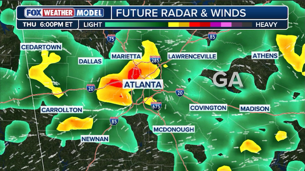
Exclusive FOX Weather Model showing thunderstorms rolling into Atlanta for the Thursday evening commute.
Travelers passing through Hartsfield-Jackson Atlanta International Airport tomorrow should prepare for potential air traffic disruptions.
The FOX Forecast Center is tracking a wave of afternoon thunderstorms expected to move through the region on Thursday, with the highest threat for storms concentrated just west of the airport.
While the most intense activity may stay slightly west, the proximity of these storms to America's busiest airport often triggers ground stops or departure delays to ensure aircraft can safely navigate around convective activity.
Door-to-door evacuations are currently underway north of Denver as high winds and unseasonably dry conditions fuel a fast-moving grass fire.
The Thornton Fire Department and neighboring agencies have cleared Pinnacle High School and surrounding neighborhoods as the fire threatens the area, forcing the closure of I-25 at 84th Avenue.
Courtesy: Thornton Fire Department on X (@ThorntonFire)
Emergency crews in Thornton, Colorado are currently battling a fast-moving grass fire that has forced the evacuation of Pinnacle High School and triggered major traffic chaos across the north Denver metro area.
Thornton Fire Department, supported by several neighboring agencies, is on the scene as heavy smoke from the blaze remains visible for miles, driven by the same high winds that have put much of the region under a Fire Weather Warning today.
In an effort to protect public safety and allow first responders better access to the scene, officials have taken the major step of closing I-25 in both directions at 84th Avenue.
The situation remains fluid as firefighters work to contain the flames near the school and surrounding businesses.
While the evacuation of Pinnacle High School was completed as a precaution, the closure of a primary artery like I-25 is causing massive delays for those traveling between Denver and the northern suburbs.
Local police are asking motorists to avoid the area entirely and seek alternate routes like Federal Boulevard or Highway 85 as the firefighting efforts continue into the afternoon.
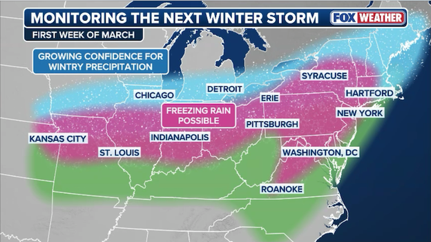
As the Northeast continues the massive task of digging out from the historic Blizzard of 2026, the FOX Forecast Center is already sounding the alarm on a complex, multi-day winter storm that could stall recovery efforts. This looming system is expected to sweep across nearly two dozen states, beginning in the Midwest this Sunday before shifting its focus toward the Northeast and Mid-Atlantic through early Wednesday.
Meteorologists are warning that this won’t be a simple snowstorm, as it is expected to arrive in two distinct waves, each packing the potential for heavy snow and dangerous ice.
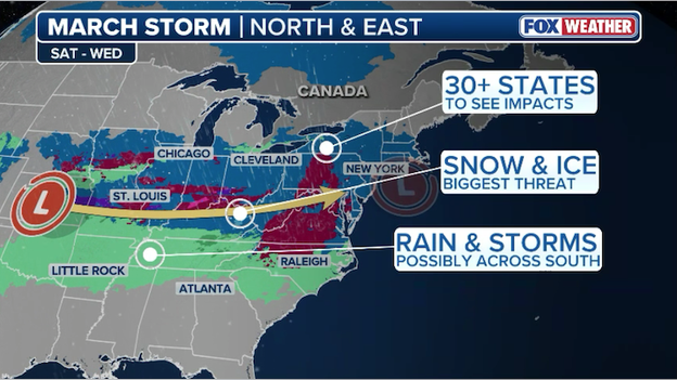
A complex multi-day winter storm is threatening to drop snow and ice on more than 30 states to start March.
The trouble starts with the timing, as the first wave is set to ignite in the Midwest on Sunday and reach the busy I-95 corridor by Monday morning. Just as commuters are navigating that first round, a second wave will focus its energy on the Northeast and Mid-Atlantic on Tuesday.
The setup is what weather experts call "overrunning," which happens when warm, moisture-rich air from the south tries to climb over a dense dome of cold air locked at the ground. This battle between air masses will keep winter hazards on the table for the duration of the event.
Right now, the forecast hinges on two major atmospheric hurdles that meteorologists are watching closely.
The first is a disturbance moving along the jet stream. Think of this as a kink in the atmosphere that provides the lift and spin needed to get a storm organized. The two main computer models are currently in a bit of a tug-of-war over how this plays out.
The GFS model is leaning into a more aggressive scenario, showing a stronger disturbance that could dump broad swaths of heavy snow and ice. On the other hand, the European model is staying "flatter" and weaker, which would mean much lighter precipitation and far less of a headache for travelers.
The second big question mark is the depth of the "cold dome" sitting over the Great Lakes and Northeast. For a major snowstorm to take shape, it has to be freezing not just at your front door, but all the way up into the clouds. If that cold air is too shallow, snowflakes will melt into sleet or freezing rain before they hit the ground.

This transition zone is particularly concerning for those along the I-70 corridor and through the Ohio River Valley, where the risk for disruptive ice is currently highest.
While the exact track is still evolving, the difference between a high-end and low-end scenario is stark. In a high-end outcome, we could see a stripe of 10 inches of snow from the Ohio Valley straight into the I-95 cities. If the storm wobbles or the air stays too warm, those totals could drop to a mere 1 to 3 inches, replaced by a slushy, icy mix that threatens power lines and trees.
Whether cities like New York and Philadelphia get buried again or just deal with a messy commute will come down to fine-scale details that are still shifting.
With critical fire conditions building across the Front Range, Black Hills Energy has declared an Emergency Public Safety Power Shutoff (PSPS) Watch for parts of Southern Colorado.
The watch is in effect for isolated portions of Fremont and Pueblo counties. If high winds and low humidity continue to escalate, the utility may be forced to proactively cut power to approximately 850 customers starting.
This "last-resort" measure is designed to prevent electrical equipment from sparking a wildfire during extreme weather.
If you are in one of the affected zones in Fremont or Pueblo counties, take the following steps immediately:
- Prepare for outages: Ensure your phones and essential medical devices are fully charged.
- Backup medical plans: If you rely on electricity for oxygen or refrigerated medicine (like insulin), have a plan to relocate or use a backup generator.
- Stay informed: Black Hills Energy will notify customers via text, email, and phone if the "Watch" is upgraded to a "Warning," which means a shutoff is imminent.
- Manual access: Make sure you know how to open your electric garage door manually so you aren't trapped if you need to evacuate.
The National Weather Service has issued a Fire Weather Warning for the region today, with gusts expected between 45 and 60 mph and humidity values as low as 5–10%. These conditions mean any fire that starts could spread uncontrollably and be extremely destructive.
Millions from the Midwest to the Northeast are on alert for a potential major winter storm to start March.
- Commute chaos: A quick-hitting Alberta Clipper has dropped an additional 1 to 3 inches of snow across the Tri-State area this morning, including 1.4 inches in Central Park and 2.5 inches in Shelton, CT.
- Ongoing power crisis: Over 245,000 customers remain without power following the blizzard. Massachusetts is the hardest hit with 160,000 outages, with some coastal restoration not expected until Friday.
- Next major threat: The FOX Forecast Center is already tracking a complex winter storm for Sunday–Tuesday that could bring heavy snow and significant ice to the same weary regions currently digging out.
- Record-breaking hurricane: The NHC's final report on Hurricane Melissa confirms it reached 190 mph sustained winds, tying for the strongest Atlantic landfall in history. It also verified a 252 mph wind gust, the highest ever recorded globally by a dropsonde.
- Catastrophic costs: Melissa is now officially Jamaica’s costliest disaster at $8.8 billion in damage, nearly 41% of the country's GDP—dwarfing the impact of 1988's Hurricane Gilbert.
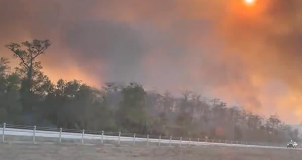
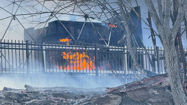
- Alligator Alley smoke alert: Visibility is dropping to near zero on I-75 in Collier County as smoke from the 25,000-acre National Fire drifts across the roadway. Florida Highway Patrol is urging drivers to use extreme caution, reduce speed, and use low-beam headlights.

Florida Department of Transportation camera along 'Alligator Alley' (I-75) in Collier County.
Drivers traveling through Collier County are being warned of life-threatening driving conditions this afternoon.
Thick smoke from the National Fire has settled over a critical stretch of I-75 (Alligator Alley), reducing visibility to near zero in some areas.
The Florida Highway Patrol and fire managers are urging extreme caution for anyone traveling between Mile Marker 76 and Mile Marker 80.
Southerly winds are expected to continue pushing dense smoke plumes directly across the highway for the remainder of the day, creating a smoke trap that can catch drivers off guard.
The National Fire, which sparked in the Big Cypress National Preserve, has exploded to approximately 25,000 acres and remains at 0% containment as of Wednesday afternoon.
While no structures are currently under threat, the heavy smoke is expected to linger into the evening hours, potentially impacting the Wednesday night commute and lowering air quality across South Florida.
As we turn the calendar to March, the atmosphere is shifting from winter's grip to the volatile energy of spring. Forecasters are already signaling that the 2026 severe weather season is ready to launch, with several key factors coming into alignment.

March serves as the traditional start of the severe weather season in the U.S., as the collision between retreating Arctic air and surging moisture from the Gulf of Mexico creates a battleground across the southern states.
While many people focus on "Tornado Alley" in the Plains, March is typically the peak time for Gulf Coast states—a region including Mississippi, Alabama, and Tennessee that faces a high risk of fast-moving, often rain-wrapped tornadoes.
With the jet stream expected to remain active and Gulf of America waters already unseasonably warm, the "fuel" is in place for a volatile month.
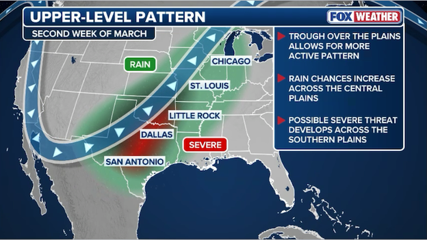
FOX Weather meteorologists are eyeing the second week of March for a rise in potential severe weather across the South.
FOX Weather meteorologists are already eyeing the second week of March for a rise in potential severe weather. While the exact details of any threat are limited, long-range models indicate a favorable pattern may develop that could spin up tornadoes and spark dangerous storms across the Southern Plains and Deep South.
Residents from the Gulf Coast into the Ohio Valley should ensure their emergency kits are ready and their FOX Weather App alerts are turned on as the pattern shifts toward its spring peak.
To gain a deeper perspective on these historic findings, Hurricane Specialist Bryan Norcross will join FOX Weather today to break down the National Hurricane Center’s final report on Hurricane Melissa.
Norcross is scheduled to appear on FOX Weather NOW at 4:30 pm ET to discuss the storm's record-breaking 190 mph winds and the unprecedented 252 mph wind gust that has redefined tropical meteorology.
The National Hurricane Center (NHC) has released its final "best track" analysis for Hurricane Melissa, officially upgrading the storm to a staggering peak intensity of 165 knots (190 mph).
This upgrade, supported by a mix of satellite data and harrowing Hurricane Hunter missions, confirms that Melissa reached its terrifying zenith on the morning of October 28, 2025, just 40 nautical miles off the coast of Jamaica.
Accurately measuring a Category 5 hurricane is a logistical nightmare. While both Air Force Reserve and NOAA aircraft flew into the heart of the storm, they were physically unable to sample every quadrant. Specifically, the northeast quadrant—typically the most violent part of a North Atlantic hurricane—remained out of reach during the storm's peak.
Despite being unable to reach the strongest winds, the data that was collected was record-breaking:
- Flight-level power: A NOAA P-3 aircraft measured a 10-second average wind speed of 173 knots (199 mph) at flight level in the southern eyewall.
- Extreme dropsondes: One eyewall dropsonde recorded a mean wind of 188 knots (216 mph) in the lowest 150 meters of the atmosphere.
- A new global record: The same dropsonde captured an instantaneous wind gust of 219 knots (252 mph) at an altitude of 906 mb. This is officially the strongest wind ever recorded by a dropsonde in a tropical cyclone anywhere on Earth.
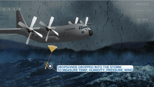
Hurricane Hunters fly a WC-130J into hurricanes to gather critical data about the storm's strength and movement.
So why the upgrade to 190 mph? Since the aircraft couldn't reach the strongest quadrant of the storm, meteorologists had to look at the blend of available evidence.
Objective satellite estimates (ADT) peaked as high as 185 knots (213 mph), while SATCON estimates reached 174 knots (200 mph).
By combining these high-end satellite estimates with the record-shattering dropsonde data and accounting for the un-sampled northeast quadrant, the NHC determined that 165 knots (190 mph) was the most accurate representative surface wind speed.
This intensity ties Melissa for the highest one-minute sustained wind speed ever recorded in the Atlantic Basin.
A final assessment from the World Bank and the Inter-American Development Bank (IDB) has confirmed that Hurricane Melissa is now the costliest natural disaster in Jamaica's history.
The storm caused an estimated $8.8 billion in physical damage, a staggering figure that represents roughly 41 percent of the nation's GDP.
This total far eclipses the previous record held by Hurricane Gilbert in 1988, which caused approximately $2.5 billion in losses (adjusted).
While Gilbert was long the benchmark for destruction on the island, Melissa’s Category 5 intensity and direct hit on critical infrastructure and tourism hubs have created an economic footprint unlike anything the country has seen before.
While the National Hurricane Center is celebrating its forecast precision with Hurricane Melissa, a new artificial intelligence challenger has proven it can go toe-to-toe with the world's top meteorologists.
In the NHC's final report on Hurricane Melissa, the agency touted its remarkable track accuracy, noting that its four-day forecast predicted the Jamaica landfall with a staggering error of just 11 nautical miles—far better than the typical margin for a 96-hour window.
Overall, the official NHC forecasts outperformed almost all traditional computer models, maintaining a skill level of over 80 percent.
However, the human experts met their match in the Google DeepMind ensemble mean (GDMI).
The official forecast outperformed nearly all available model guidance at all forecast lead times. The exception was the Google DeepMind ensemble mean (GDMI) which performed remarkably well at all time periods and was considerably more skillful than most of the other track guidance.
According to the report, the Google AI performed remarkably well across the board, proving to be considerably more skillful than the majority of other track guidance available during the storm.
While the official NHC forecast managed to edge out the AI at the 120-hour mark, the Google DeepMind model was comparable to the human experts through the 96-hour lead time, signaling a major shift in how the world's most dangerous storms will be tracked in the future.
Courtesy: NOAA
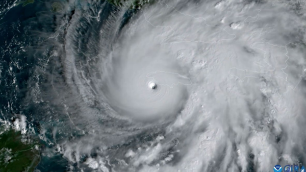
The National Hurricane Center just officially confirmed that Hurricane Melissa has secured its place as one of the most terrifying storms in meteorological history.
When the Category 5 monster slammed into New Hope, Jamaica, on October 28, 2025, its 185 mph sustained winds officially tied it for the strongest landfall on record in the Atlantic Basin.
Melissa now shares this grim top spot with only two other historic storms: the 1935 Labor Day hurricane and 2019’s Hurricane Dorian.
Beyond its landfall intensity, Melissa has set a staggering new global benchmark for sheer wind power. Verified data from a NOAA Hurricane Hunter dropsonde captured a 252 mph wind gust as the storm approached the coast—the highest wind speed ever recorded in a tropical system globally.
This unfathomable measurement surpassed the previous record of 240 mph set by Typhoon Megi in 2010 and ranks as one of the highest wind gusts ever recorded on Earth.
Record-breaking stats for Hurricane Melissa
- Strongest in the Atlantic: 190 mph (Tied for #1 in Atlantic history)
- Landfall sustained winds: 185 mph (Tied for #1 in Atlantic history)
- Peak wind gust: 252 mph (Highest ever recorded in a tropical cyclone)
- Minimum central pressure: 892 mb (Tied for #3 strongest in the Atlantic)
- Impact: Strongest storm to ever hit Jamaica, surpassing 1988's Hurricane Gilbert
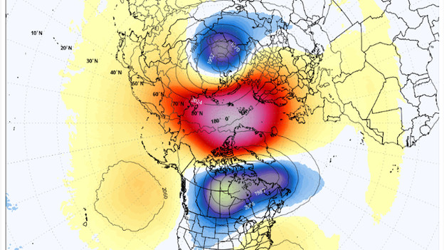
Global Forecast System (GFS) model showing a Sudden Stratospheric Warming event over the North Pole in early March.
Just as the Northeast is beginning to surface from a historic blizzard, a new atmospheric shake-up is brewing high above the North Pole.
The FOX Forecast Center is closely monitoring a potential Sudden Stratospheric Warming (SSW) event for early March, which could once again destabilize the polar vortex and send Arctic air surging back into the U.S.
The polar vortex is a massive, rotating expanse of cold, low-pressure air that always exists near the Earth's North and South Poles. While it is a permanent feature high in the atmosphere (found in the stratosphere and troposphere), it becomes most influential in the winter as it strengthens and occasionally expands, sending frigid Arctic air southward into the United States.
This isn't just a standard winter update—it’s a rare atmospheric "double-header." Major SSW events typically occur only once every other year, and seeing two distinct major warmings in a single winter season happens roughly once every 10 years.
Having already experienced a significant disruption in January that contributed to the recent record-breaking cold, a second collapse of the polar circulation in early March would be an extraordinary bookend to the 2025–2026 winter season.
A second major stratospheric warming event of the season would likely have a profound impact on weather patterns across the United States throughout the month of March.
When the stratosphere warms this significantly, it often leads to prolonged cold spells across the Central and Eastern U.S. as the weakened polar vortex allows frigid Arctic air to bleed southward into mid-latitudes.
These disruptions typically weaken the jet stream, creating blocking patterns in the atmosphere that can stall weather systems and significantly increase the frequency and intensity of major snow events.
Perhaps most frustrating for those eager for warmer weather is that these atmospheric changes often lead to a delayed spring. Because it can take anywhere from four to six weeks for the effects of an SSW to filter down from the stratosphere to the surface where we feel them, an event occurring in early March could keep winter's grip firm well into the month of April.
FOX Weather meteorologists says we don't know yet whether or not this SSW will result in an outbreak of frigid air across the United States, but say this rare atmospheric double-whammy essentially will ensure that the transition to milder temperatures could be a slow, rocky process for much of the country.
A new snow report from East Meadow, New York, confirms 1.8 inches of fresh accumulation has fallen as this morning's clipper system moves across Long Island.
This additional snow adds another layer of difficulty for Nassau County residents who are still working to clear massive drifts from the Blizzard of 2026.
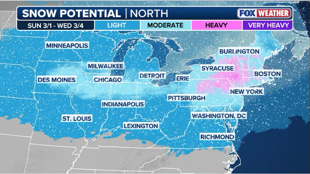
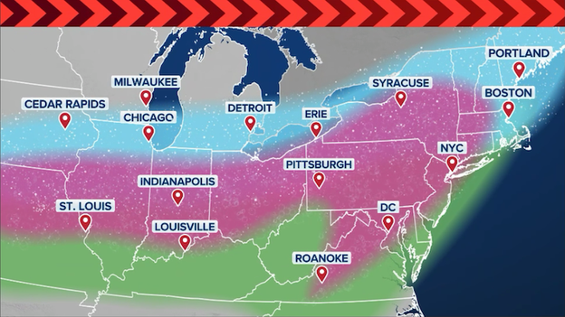
Computer forecast models are showing a moderate-to-heavy snowstorm from the Midwest to the Northeast through early next week.
As the Northeast digs out from the Blizzard of 2026, the FOX Forecast Center is already tracking a complex winter storm slated to arrive as March kicks off. While the threat of a major event is far from negligible, meteorologists are highlighting several atmospheric hurdles that make this particular forecast a significant challenge.
The primary difficulty lies in the interaction between a shot of cold air moving across the northern tier on Saturday and a disturbance ejecting from the Rockies on Sunday.
Because this system is pulling in humid, warmer air from the south, a process called "overrunning" will occur as that moisture glides over the dense cold air near the surface.
The biggest wildcard for snow totals remains the transition line where cold air meets warm moisture. Forecast models are currently grappling with the depth of the cold air mass; if the layer of freezing air is too shallow, many major cities could see snow transition into sleet, freezing rain, or plain rain.
This mixing is a major concern along the I-70 corridor and the Ohio River Valley, where the threat of a disruptive ice storm is highest, based on current data.
Even slight shifts in the jet stream's position could determine whether a city like New York or Philadelphia sees a half-foot of fresh powder or a messy, slushy mix that cuts down accumulation but increases the risk of power outages from ice-heavy lines.
The FOX Forecast Center is closely monitoring three specific factors that will decide the storm's ultimate impact:
- Rockies energy: The amount of energy that successfully ejects from the Western trough will dictate the overall strength and moisture content of the storm. Think of the energy coming out of the Rockies as the engine of the storm. Meteorologists are watching to see how much fuel (energy and moisture) this system picks up as it moves toward the East. If the storm emerges from the mountains with a lot of energy, it will be stronger and capable of carrying much more moisture. However, if that energy stays trapped out West or peters out, we could end up with a much weaker, less impactful system.
- Jet stream positioning: If the jet stream dip over the Northeast holds firm, it could block Pacific moisture from reaching the coast, resulting in a much weaker system. The jet stream is like a high-altitude river of air that steers weather systems. Currently, there is a dip in that river sitting over the Northeast. If that dip stays strong and rigid, it can act like a defensive wall, blocking the moisture coming from the Pacific and the Rockies from reaching our coast. If that wall holds, the storm could be pushed out to sea or fizzle before it hits, but if it shifts or weakens, the door opens for a major snow event.
- Temperature depth: Meteorologists are tracking whether the "cold dome" over the Great Lakes and Northeast is deep enough to prevent rain from infiltrating the snow bands. For it to snow, it doesn't just need to be cold on the ground; it needs to be cold all the way up through the atmosphere. Meteorologists call this the cold dome. As warm, humid air tries to push north, it will ride up over this dome of cold, heavy air. If that cold air is deep (meaning it extends from the ground all the way up to the clouds), the precipitation stays as snow. If the cold air is too shallow or thin, the warm air can melt the snow into rain or sleet before it hits the ground, which is how we end up with a slushy mess instead of a winter wonderland.
For now, everyone from the Midwest to New England should be closely monitoring the forecast as forecasters fine tune where the heaviest snow and ice will fall.
A new snow report from Shelton, Connecticut, reveals 2.5 inches of fresh accumulation has fallen as this morning's clipper system moves through Fairfield County.
This quick burst of snow is adding another layer of difficulty for local crews who are still working to clear the massive drifts left behind by the recent blizzard.
Now that the snow has ended, New York City's Central Park has officially recorded 1.4 inches of fresh snow from this morning's quick-hitting clipper system.
FOX Weather meteorologists are monitoring a winter storm that could deliver snow, freezing rain, and ice to millions in the first week of March.
A powerful new winter storm is set to roar into the Northeast just as March begins, potentially burying the region under fresh layers of snow while millions are still digging out from the Blizzard of 2026.
The setup kicks off this Saturday as a blast of cold air takes hold of the northern third of the country, setting the stage for a moisture-heavy disturbance rolling in from the Rockies on Sunday.
As warm, humid air is funneled north, it will override the dense cold air in place—a process known as "overrunning"—creating a messy shield of snow, sleet, and freezing rain across the Mississippi Valley, the Great Lakes, and eventually the Northeast.
While major cities like Chicago, Cleveland, and Pittsburgh could see impacts as early as Sunday, the storm is expected to track toward Philadelphia, New York, and Boston shortly after.
Meteorologists at the FOX Forecast Center warn that while the threat of a significant storm is clear, the exact magnitude remains a work in progress. The severity of the impacts will depend on how much Pacific energy makes it east and how strongly the jet stream holds over the Northeast, but with the current data, the risk of a major winter event is far from negligible.
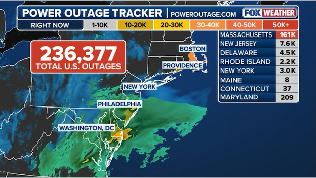
More than 235,000 customers are still without power as more snow hits the Northeast.
Restoration efforts are facing another hurdle this morning as a fresh coating of snow sweeps across a region already struggling with widespread power failures.
According to the latest data from PowerOutage.com, over 235,000 customers remain without electricity as of Wednesday morning.
While utility crews have made significant progress since the height of the blizzard, the arrival of a new clipper system—bringing an additional 1 to 3 inches of snow—complicated the final push to get everyone back online.
The burden of these outages continues to fall most heavily on Massachusetts, where a staggering 160,000 customers are still waiting for the lights to come back on.
Other states in the region are also seeing persistent issues, including New Jersey with over 8,400 outages and Delaware with approximately 5,100.
With temperatures remaining below freezing, local authorities are urging those without heat to seek out warming centers as crews battle the new snow and icy conditions to reach damaged lines.
See updates from the Blizzard of 2026 recovery with FOX Weather's LIVE Winter Storm HQ coverage from Tuesday.
You’ve reached the beginning of this live coverage.