Live updates: Nor'easter bomb cyclone threatens millions on East Coast with heavy snow, intense wind
Live updates: Nor'easter bomb cyclone threatens millions on East Coast with heavy snow, intense wind
Download the AppLIVE Winter Storm HQ coverage continues
View postCoverage for this event has ended.
LIVE coverage has ended here, but FOX Weather is providing 24-7 updates all day and night to help keep you and your family safe.
In Benton, Arkansas, a pool hall fully collapsed, causing three offices to partially collapse.
"It is very probable that the collapse was caused by the weight of accumulated snow and ice on the structure," Pulaski County Government wrote on Facebook.
Mississippi Governor Tate Reeves said three more deaths have been reported, bringing the total to 10 statewide.
The addition of three more deaths brings the U.S. death toll to 60.
The governor also said the Mississippi Emergency Management Agency has received reports of 208 homes, five businesses and seven farms damaged or destroyed due to last weekend's storm.
Reeves said that 20 public roads have sustained major damage and 12 have been destroyed.
On Tuesday at 3:30 p.m. local time, the Saline County Fairgrounds rodeo arena collapsed under the weight of snow and ice after a major winter storm brought rare winter weather to Arkansas and other areas across the South on it's more than 2,300-mile-long path across the US.
Saline County Judge Matt Brumley provided an evening update near the collapsed rodeo arena, and said, "It's just a sign of how thick, dense and heavy the elements and what is left behind of this winter storm are."
According to Brumley, the arena seems to be a total loss. The prolonged impact of dangerous winter weather is beginning to take a toll across the region, as frigid temperatures lock in snow and ice across the South.
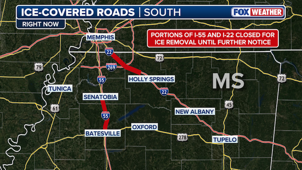
This graphic displays the two ice-covered major highways in Mississippi. The dark red line highlights the portions of each highway that are closed.
The Mississippi Department of Transportation announced the temporary closure of I-22 and I-55 until further notice to allow MDOT crews access to work on ice removal efforts.
The closure includes the northbound lanes of I-55 from Batesville (Exit 243) to Senatobia (Exit 265) as well as the entirety of I-22 / U.S. 78 from Red Banks (Exit 21) to the Tennessee state line.
Governor Andy Beshear reported on X that Kentucky's winter storm-related death toll had risen to 11 after a 55-year-old man died in Livingston County.
There has been at least 57 deaths reported across more than a dozen states in the aftermath of the major winter storm that rolled over 2,300 miles across the Southern Tier of the U.S. and brought dangerous winter weather to the doorstep of millions of Americans.
The Oxford campus at the University of Mississippi announced they'll be closed through Sunday, Feb. 8 due to the extreme impact and ongoing recovery efforts following last weekend's winter storm.
This closure means all classes, events and activities will be canceled. The university said they'll continue to evaluate conditions and will notify the campus community of any updates.
People in Oxford are seeing crippling effects from the winter storm, including an inch of paralyzing ice that caused widespread power outages and a plethora of downed trees and power lines.
There are still over 16,000 power outages in Lafayette County, where Oxford is located, according to poweroutage.us.
Click here for more information.
The winter storm-related death toll now exceeds 50, with eight additional deaths reported in Kentucky on Wednesday.
Kentucky Governor Andy Beshear announced that eight more people have died due to last weekend's winter storm, bringing the total death toll to 56.
With two prior deaths confirmed in the state, the announcement means 10 total deaths have been reported in Kentucky.
The South Carolina Department of Public Health confirms that two people have died as a result of the winter storm last weekend.
An 83-year-old woman died from hypothermia while outside on Sunday. This follows another death that happened on Monday, where a 96-year-old woman died in Greenwood County, according to officials.
This marks the 48th death caused by last weekend's catastrophic storm. Local officials across 16 states have confirmed the deaths are attributed to the extreme weather.
Click here for more information.
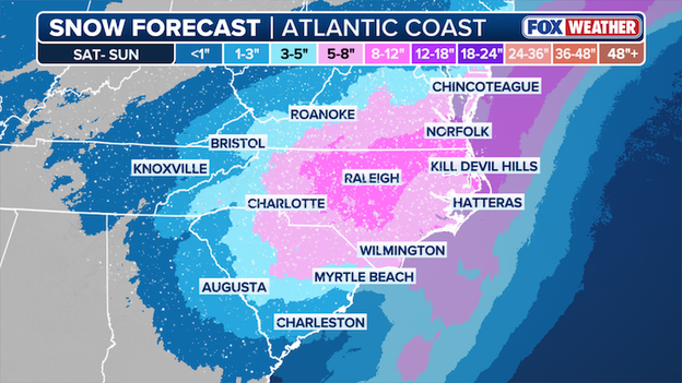
A powerful nor'easter is forecast to bury parts of the Carolinas and Virginia in nearly a foot of snow.
Millions along Interstate 95 on America's East Coast are bracing for a powerful nor'easter this weekend that could bury portions of North Carolina and Virginia in heavy snow. The storm is expected to take shape late Friday, with snow spreading across the Appalachians and into North and South Carolina by the evening. As the coastal low strengthens offshore, bands of heavy, wet snow will setup over the Carolinas and into Virginia through Saturday. The initial snow forecast from the FOX Forecast Center calls for up to a foot of snow to fall near Raleigh, North Carolina and into southern Virginia.
FOX Weather's snow forecast for the upcoming weekend nor'easter.
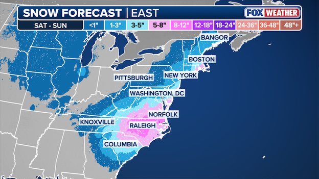
A major winter storm is brewing that will dump heavy snow on America's East Coast this weekend. The FOX Forecast Center just released its first snow forecast which calls for up to a foot of snow to fall on North Carolina. The heavy, wet snow could make travel impossible by early Saturday morning across the state.
The storm is then expected to slide up the coast and "bomb out," as it intensifies rapidly over the Atlantic Ocean. Based on this first snow forecast, it appears the heavily-populated I-95 corridor from Washington to New York will miss out on the worst snow - just an inch or two for the nation's capital and New York City. But Massachusetts and Cape Cod could bear the brunt of the storm with snow totals near a half foot and dangerously strong winds up to 70 mph on Sunday.
At least 46 deaths have been reported from last weekend's historic winter and dangerous cold. Local officials across 16 states have confirmed the deaths are attributed to the extreme weather.
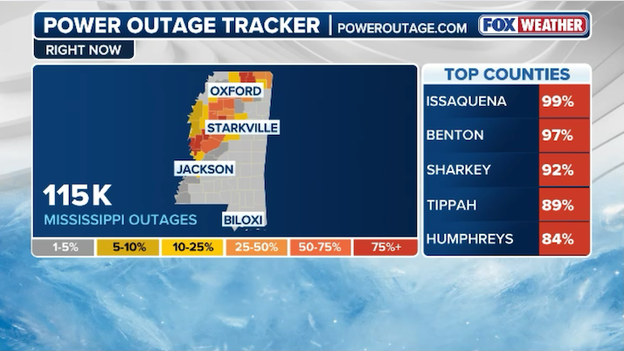
Power outage tracker showing current outages across Mississippi. (PowerOutage.com)
Utility crews are working around the clock to restore electricity to the thousands left without power from last weekend's historic winter storm. Data from PowerOutage.com shows more than 115,000 customers are still without power at this hour. Extra lineman and additional crews have been brought in to repair the hundreds of power poles and major transmission lines damaged by the ice that coated North Mississippi.
A nor'easter is expected to develop along America's East Coast this weekend.
While thousands across the South are still without following last weekend's historic winter storm, forecasters warn time is running out to prepare for the next one. The FOX Forecast Center has been tracking a new potential threat for days and says this next storm could dump heavy snow and whip up intense winds for coastal communities along America's East Coast.
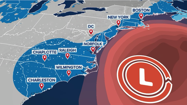
The latest forecast from FOX Weather shows this storm developing on Saturday just off the coast of the Carolinas. Places like Charlotte, Raleigh, and Wilmington in North Carolina may be looking at a significant snowfall, with Charleston, Greenville, and Columbia, South Carolina getting in on some snow, too.
FOX Weather is providing around-the-clock coverage as this new storm threatens millions along the Eastern Seaboard.
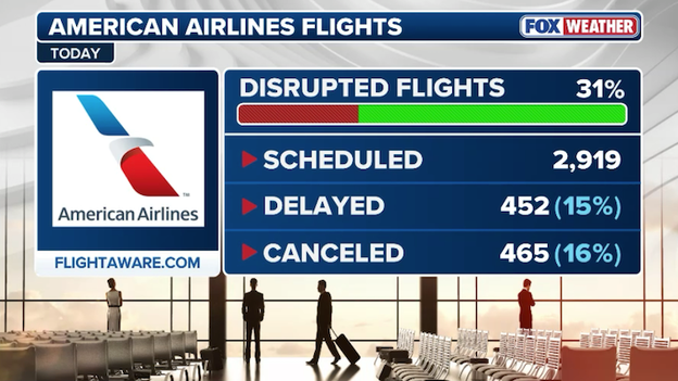
FlightAware data shows more than 30% of American Airlines' flights have been disrupted today.
American Airlines says its operation faced some of the worst weather this past weekend with snow and ice blasting many of its major hubs. The airline has been working ever since to get things back on track, but data from FlightAware shows it is still struggling today. Nearly 1/3 of American's total schedule has been disrupted (canceled or delayed) today.
The airlines says customers are encouraged to check the American Airlines app and the company's website for the latest flight status. It also says its passengers should take advantage of the additional flexibility provided by the two travel alerts issued for the storm, which was extended through Thursday.
For the first time in several years, frigid temperatures have caused ice to form in New York Harbor and in New York's Hudson and East Rivers. The huge chunks of ice have forced NYC Ferry to suspend all ferry service until further notice. NY Waterway, which operates ferry service between New York and New Jersey across the Hudson River, says that dense ice is causing delays on all routes.
The safety of all crew, passengers, and vessels is of the utmost importance, and NYC Ferry crew continues to monitor evolving waterway conditions and prepare the fleet to ensure service can resume once conditions improve.
The United States Coast Guard is now working to break up the dangerous ice and clear pathways for ferries and other ships to pass through safely, but the continued cold weather will lead to additional ice building up in the days ahead.
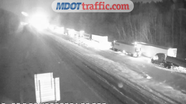
MDOT camera showing stranded vehicles on I-22 and Victoria Road near Olive Branch, Mississippi.
Road conditions went from bad to worse overnight in Mississippi as temperatures dropped back below freezing. After briefly warming warming up to near 37°F on Tuesday afternoon, temperatures tanked after the sun set and standing water on many roads turned to ice.
Right now, Interstate 22 is at a standstill. Mississippi Department of Transportation cameras show stranded vehicles lined up on the road. Some of the drivers have been stuck since before midnight. We're told a similar situation can been seen on Interstate 55 in the northern part of the state.
In an X post overnight, Mississippi Governor Tate Reeves said emergency responders were swarming the area. Drones and emergency rescue vehicles were being brought in to clear the stalled vehicles and assist those stranded on the road.
Governor Reeves is telling everyone to take all measures to avoid the still-dangerous conditions in his state.
In response to the winter storm, FEMA, under the leadership of President Trump and Secretary Noem, is rapidly deploying specialized “hotshot crews” from the U.S. Forest Service to Mississippi and Tennessee to assist local and state-led teams with removing debris from roadways, allowing emergency access. This will help ensure power can be restored in the most affected areas.
President Trump approved 12 federal emergency disaster declarations for Arkansas, Georgia, Indiana, Kentucky, Louisiana, Maryland, Mississippi, North Carolina, South Carolina, Tennessee, Virginia and West Virginia, enabling states to access critical federal resources to supplement their response efforts.
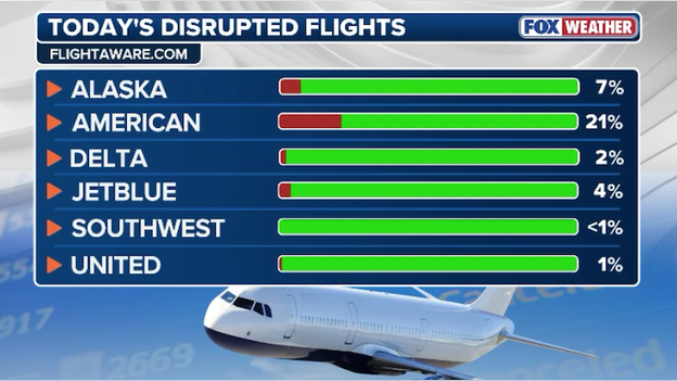
FlightAware data showing more than 20% of American Airlines flights have been disrupted so far today.
Airlines were forced to cancel more than 20,000 U.S. flights between Friday and Monday as the historic winter storm hit dozens of major airport hubs. Since then, airline operators have worked around the clock to get things back on schedule, moving equipment and crews to the right places across the country. This morning, data from FlightAware shows significant improvement from recent days. Less than 1,000 flights have been canceled so far today.
American Airlines has faced some of the worst problems with snow and ice blasting many of its major hubs. In a press release late Tuesday, the airline said ramp conditions are improving, departures are increasing, and taxi times are normalizing, allowing the airline to ramp up its schedule again. FlightAware data shows more than 20% of American's flights have been disrupted (canceled or delayed) so far today.
Cancellations are not what we want for our customers or our team members, and teams across the airline are working diligently to minimize them.
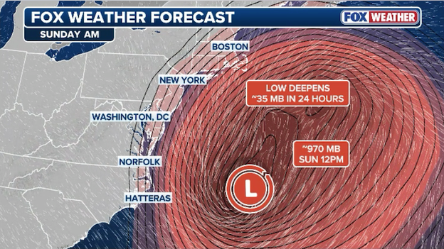
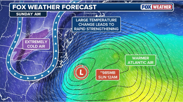
A powerful nor'easter is expected to rapidly intensify into a bomb cyclone this weekend.
You've probably heard the term "nor'easter," but few actually know it's meaning. It's strong low-pressure system that impacts the East Coast of the U.S., particularly the Northeast and mid-Atlantic. A storm is considered a nor’easter if its winds blow from the northeast off the Atlantic Ocean. If the winds are out of the east or southeast during the storm, then it’s not a nor’easter, but the impacts will likely be very similar. Although most people associate nor’easters with heavy snowstorms that move up the northeastern coast of the U.S. during the winter, not every nor’easter produces snow.
And then there's the "bomb cyclone." The term comes from the meteorological term "bombogenesis" or "explosive cyclogenesis." This happens when a storm system's central pressure drops at least 24 millibars within 24 hours. A low pressure system that achieves this mark becomes known as a "bomb cyclone." Meteorologists also use the phrase "bomb out" to describe the phenomenon.
This weekend's developing storm will be both - a nor'easter bomb cyclone. Low pressure is forecast to form off the coast of the Carolinas on Saturday and slide up the coast just offshore. It's orientation and track will produce powerful northeast winds at the coast (there's your nor'easter), which could lead to coastal erosion and big beach impacts. While it's moving north, it's also going to intensify very quickly, with the pressure dropping about 35 millibars within 24 hours (and there's your bomb cyclone).
For those living in the Carolinas, Virginia, Maryland, Delaware, New Jersey, New York, Connecticut, Rhode Island, and Massachusetts, it's time to start thinking ahead for a possible storm that could dump heavy snow along the East Coast.
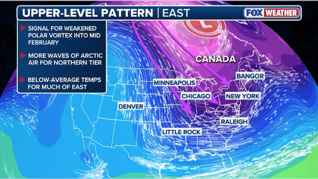
Upper-level pattern shows favorable conditions for more extreme blasts of cold air into the eastern half of America.
Here's one way to sum up the forecast for the eastern half of America: WYSIWYG (What You See Is What You Get).
Following years of mild winters, cold weather has come back with a vengeance in early 2026 and it shows no signs of letting up anytime soon. FOX Forecast Center meteorologists are keeping a close eye on the 'polar vortex' as we head into February. There are signs that it may weaken and wobble over the North Pole into mid-February, which would allow dangerously cold air to dive south into the U.S. Experts say chances are if you're cold now, you're going to be cold for weeks to come.
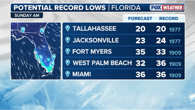
Forecast record low temperatures in Florida on Sunday morning.
Florida, get ready: it's about to get cold. Real cold.
The Sunshine State is about to experience some of the coldest weather in years. Arctic air is forecast to plunge south into the state over the weekend. Temperatures are expected to drop below freezing (32°F) by Sunday morning as far south as West Palm Beach, Florida.
Even Miami won't be able to escape this one. The FOX Forecast Center says the temperature could dip into the mid-30s on Sunday across Miami-Dade County.
More than 40 record lows are possible Sunday and Monday mornings, including Tallahassee, Tampa, Fort Myers, West Palm Beach, and Miami. Miami's record low on Sunday is 36°F set in 1909 - and the current forecast calls for that record to be tied this weekend. As if that wasn't bad enough, strong winds will push wind chill values into the 20s on Sunday and Monday.
FOX Weather has now confirmed that at least 41 people across more than a dozen states have died as a result of last weekend's winter storm and the ongoing extreme cold.
This is a developing story, so check back for updates.
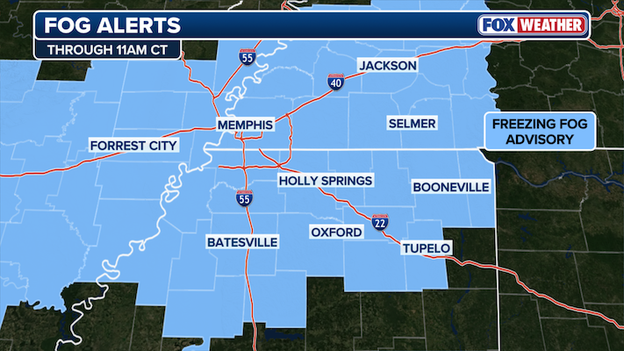
Freezing Fog Advisory in effect for portions of Arkansas, Mississippi, and Tennessee.
Freezing fog has developed across parts of the South, dropping visibility for drivers in the area. The National Weather Service issued a Freezing Fog Advisory for portions of East Arkansas, North Mississippi, and West Tennessee where visibility could drop below one quarter of a mile at times this morning.
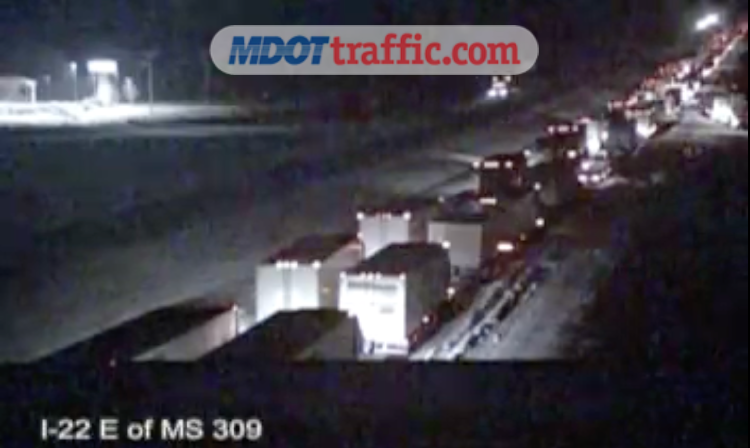
Even though the monster winter storm that crippled the South in devastating ice is long gone, the danger continues in communities hit hard by the storm. Dozens of cars and trucks are trapped on Interstates 22 and 55 in North Mississippi right now after wet roads turned to ice overnight.
The FOX Forecast Center says for a brief time on Tuesday afternoon, air temperatures climbed above freezing (>32°F) in the region. Ice leftover from the weekend storm began to melt thanks to the warmer temperature and the sun's rays beaming down on the area, leaving water dripping from trees and puddles forming on the roads. But trouble began brewing on Tuesday evening as the sun set on Mississippi.
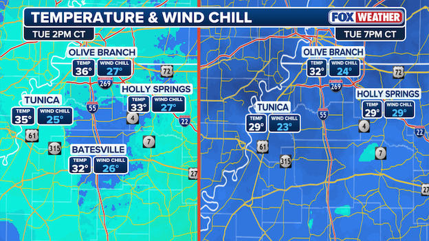
Temperature comparison showing Tuesday afternoon and Tuesday evening temperatures in Mississippi.
Analysis from the FOX Forecast Center reveals air temperatures began to tumble after nightfall. By 6 p.m. CT, most spots were back below 32°F and the standing water that had melted just hours before began to refreeze. Roads turned to ice again, catching many drivers off guard since the process happens so quickly and without warning.
This dangerous thaw-freeze cycle is expected to happen again and again this week as the state struggles to recover from the storm. Meteorologists say drivers should exercise extreme caution if venturing out in the affected areas until the weather finally warms up - which may not happen for at least another week.
Right now, more than 380,000 customers across the South are still without power following last weekend's monster winter storm. Most of the outages are in Tennessee, Mississippi, and Louisiana where crippling amounts of ice paralyzed the region.
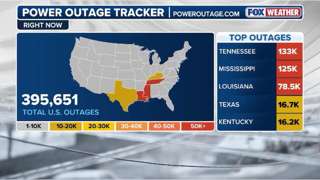
Latest power outages tracker showing outages across the South. (PowerOutage.com)
At the height of the storm on Sunday, more than 1,000,000 customers were without power. Sicne then, utility crews have been working around the clock across a half dozen states to restore service to the affected communities.
FOX Weather meteorologists say America's next big weathermaker is just days away - another major winter storm - somewhere along the East Coast. This storm will be different from last weekend's in that a coastal low will develop off the U.S. East Coast, producing snow and strong winds near the coastline.
Right now, a pronounced dip in the jet stream is parked over the eastern part of the nation. This "trough" will serve multiple roles: including reinforcing cold air across the region and shifting the overall storm track farther to the south. As a strong upper-level disturbance moves along the jet stream late week, it is expected to produce an area of low pressure off the East Coast.
A big dip in the jet stream will help fuel a developing nor'easter this weekend off the East Coast.
The likelihood of a significant coastal storm is increasing, though uncertainty remains regarding exactly where the system may develop and the track it would ultimately take. If a storm does form, it would likely be considered a nor'easter - a powerful storm with strong northeasterly winds along the coast.
Forecasters say this storm has the potential to "bomb out," or rapidly intensify. This is in reference to bombogenesis, which is defined by at least a 24 millibar (pressure) drop in 24 hours. You'll often see this referred to as a "bomb cyclone" in various references and headlines.
Forecast models indicate this storm could go from 1008 millibars to 970 in just a single day. That pressure drop could mean nasty winds and erosion at the coast.
You can go back and see live updates from Tuesday's coverage.
You’ve reached the beginning of this live coverage.