

Live updates: Deadly post-tropical Isaias charges inland, unleashing vicious impacts on the South
Live updates: Deadly post-tropical Isaias charges inland, unleashing vicious impacts on the South
Download the AppCoverage for this event has ended.
As the remnants of Hurricane Isaias move farther inland Sunday, millions of people across the Northeast and Mid-Atlantic are bracing for a soggy end to the weekend, with heavy rain, flooding and even severe thunderstorms possible.
Major cities along the Interstate 95 corridor, including Washington, D.C., Baltimore, Philadelphia and New York City, could see a complete washout Sunday, with rain expected to fall throughout much of the day. Similar conditions are expected farther inland in Pittsburgh, Cleveland and Charleston, West Virginia.

Hurricane Isaias left a deadly trail of destruction across the Gulf Coast after making landfall near Destin, Florida, as a Category 2 hurricane with 105-mph winds.
At least four people have died — two in Florida and two in Alabama — as powerful winds toppled trees, damaged homes and knocked out power across the region.
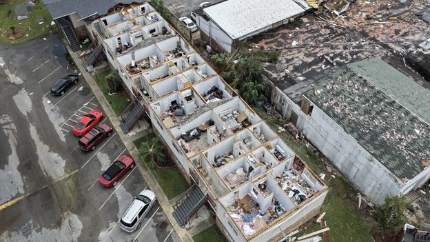
An apartment complex had its roof was blown off when Hurricane Isaias passed through Milton, Florida.
Nearly 900,000 customers across Florida, Alabama and Georgia initially lost power.
More than 400,000 customers remained without electricity Saturday evening as utility crews assessed damage and began restoration efforts.
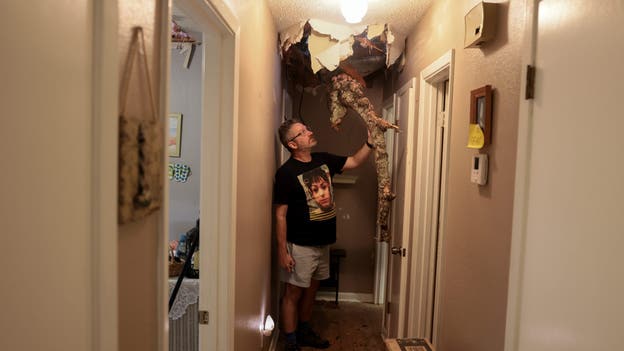
A man stands beside a tree branch that crashed through the roof of his mother's home in Milton, Florida. Credit: Getty Images.
Isaias has since weakened to a post-tropical cyclone, but the storm’s impacts aren't over just yet.
The Weather Prediction Center said heavy rain and flash flooding will continue spreading across the Southeast and Southern Appalachians before the remnants move into the Mid-Atlantic and Northeast on Sunday.
Flood watches remain in effect for parts of the Southeast and Mid-Atlantic, where saturated ground, rising waterways and additional rainfall could create dangerous travel conditions into Monday.
Hurricane Isaias was no ordinary hurricane when it slammed into Florida's Gulf Coast, with some of the worst wind damage occurring in an unexpected location.
According to the FOX Forecast Center, the strongest winds and most significant damage were concentrated west of the storm's center, rather than on the eastern side, where a hurricane's most powerful winds are typically found.
So, what caused this unusual pattern?
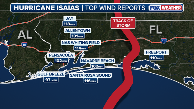
Top wind reports during Hurricane Isaias.
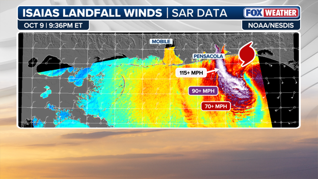
SAR data.
The FOX Forecast Center believes Isaias was already transitioning into a non-tropical storm as it made landfall, potentially allowing a weather phenomenon known as a "sting jet" to develop.
A sting jet is a narrow band of extremely powerful winds that rushes down from higher in the atmosphere toward the ground, potentially causing intense damage in a relatively small area.
Satellite radar imagery from NOAA captured a narrow band of powerful winds near Pensacola, Florida, supporting the FOX Forecast Center's theory that a sting jet may have contributed to the unusually severe damage.
The findings suggest Isaias was undergoing significant changes as it made landfall, potentially explaining why some of its most destructive winds struck areas that typically would not experience the worst of a hurricane.

Post-tropical Cyclone Isaias is moving toward Tennessee late Saturday night, but the storm’s flood threat remains far from over across the Southeast and Southern Appalachians.
The Weather Prediction Center said Isaias was located about 75 miles south of Nashville at 10 p.m. CDT, moving northeast at 16 mph with maximum sustained winds of 25 mph and higher gusts.
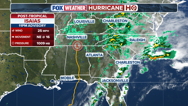
11 p.m. ET Advisory from the Weather Prediction Center.
Flood watches remain in effect across portions of the Southeast and Southern Appalachians, while a high wind warning covers parts of the Southern Appalachians.
Wind advisories are also posted across portions of the Southeast and Southern Appalachians.
The storm is expected to continue moving northeast on Sunday with little change in strength during the next 24 to 36 hours before being absorbed by another area of low pressure to its east.
The WPC said the greatest threat is additional heavy rain and dangerous flooding.
The Southern Appalachians, from the western Carolinas into western Virginia, could receive another 2–5 inches of rain, with isolated totals reaching 10 inches.
Additional rainfall of 1–2 inches is possible across the Florida Big Bend and northwest Florida, pushing storm totals toward 12 inches.
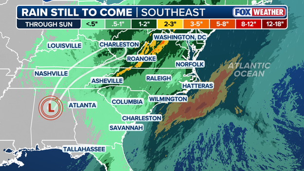
FOX Forecast Center rain forecast through Sunday.
Coastal areas of the Carolinas could see another 2–4 inches, with isolated totals up to 6 inches.
The heavy rain could trigger flash, urban and river flooding, while considerable impacts — including landslides — remain possible across the Southern Appalachians.
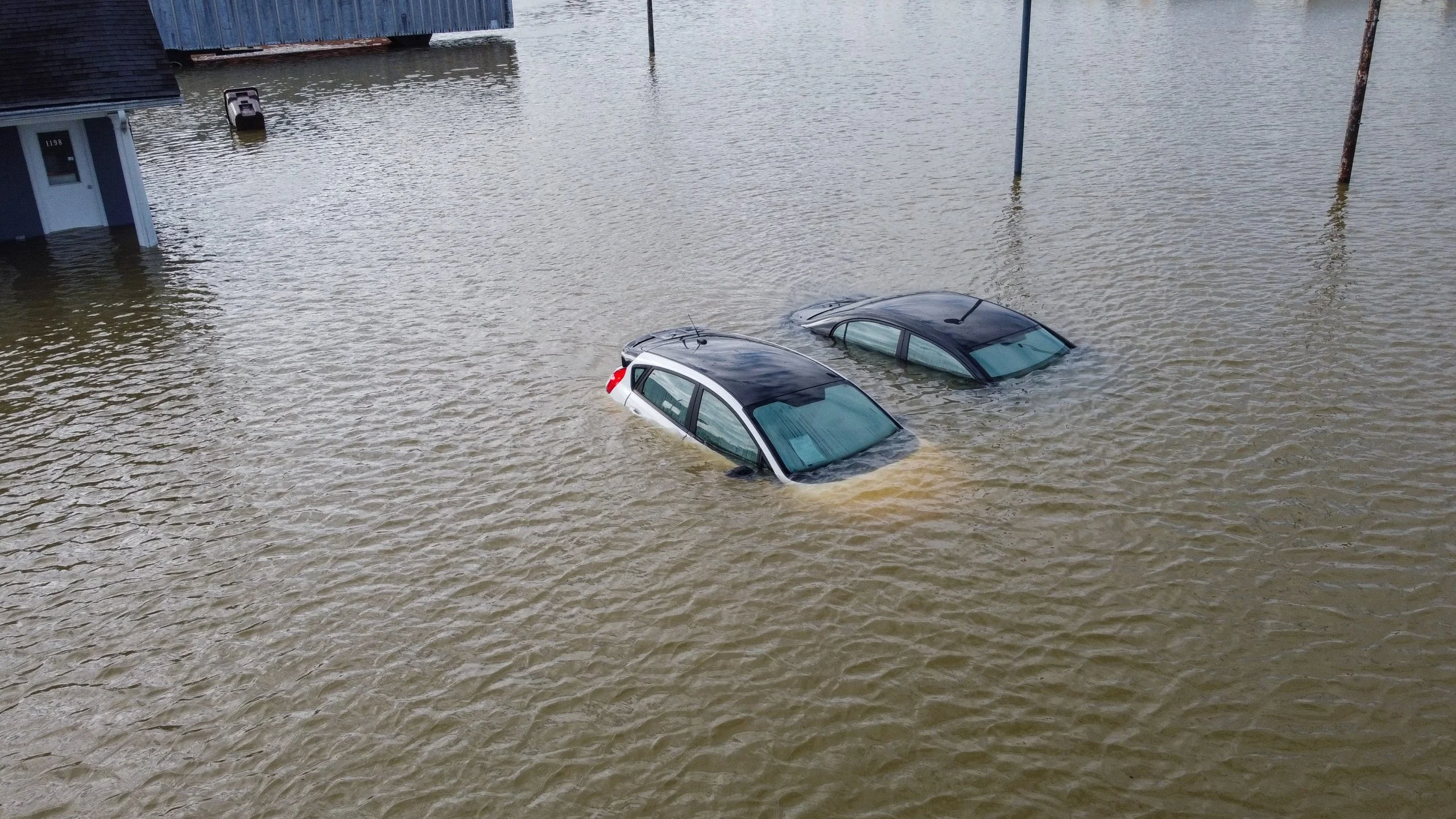
Significant river flooding in the western Florida Panhandle is expected to crest through Sunday.
Even as Isaias loses its tropical characteristics, its moisture and broad circulation continue to fuel dangerous flooding across parts of the Southeast.
The tornado threat from Isaias isn't over yet, with another round of severe weather possible Sunday as the storm's remnants move across the East Coast.
According to the FOX Forecast Center, a Level 2 out of 5 severe weather threat stretches from Washington, D.C., to Wilmington, North Carolina, where warm, moisture-rich air could fuel strong thunderstorms.
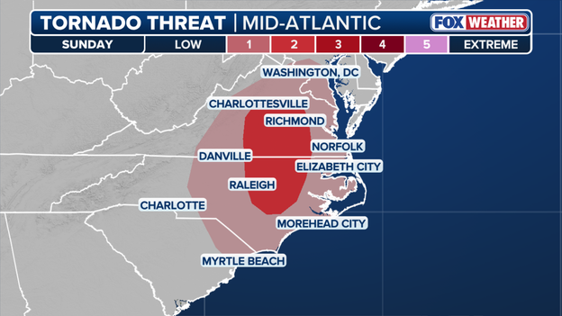
Tornado outlook along the East Coast on Sunday.
The main concerns will be brief tornadoes that develop quickly and damaging wind gusts up to 60 mph, posing additional dangers to communities already dealing with impacts from Isaias.
The severe weather threat comes as widespread rain spreads into the Northeast and Mid-Atlantic, with conditions expected to improve Monday as the system moves offshore.
Millions across the Northeast and Mid-Atlantic are bracing for a Sunday washout as the remnants of Hurricane Isaias bring widespread rain, flooding concerns and severe thunderstorms.
According to the FOX Forecast Center, Washington, D.C., Baltimore, Philadelphia and New York City could see rain nearly all day, with widespread totals of 1 to 2 inches and locally higher amounts possible.
A Level 1 out of 4 flash flood risk stretches from New York City to Washington, D.C., south toward the Outer Banks and west into West Virginia.
Farther south, a Level 2 out of 5 severe weather threat extends from Washington to Wilmington, North Carolina, where isolated tornadoes and damaging wind gusts up to 60 mph are possible.
Conditions are expected to improve Monday as the remnants of Isaias move offshore, with lingering showers clearing by midday.
Search and rescue teams are navigating dangerous conditions in Florida's Panhandle as recovery efforts continue following Hurricane Isaias.
Palm Beach County Fire Rescue's Urban Search and Rescue Team is conducting searches across large areas of Walton County, near the Alabama border, where some roads have been washed away by the storm.
Rescue specialists are using GPS systems to relay critical information to command centers while navigating debris and downed trees. The team is equipped to clear obstacles and continue searching areas impacted by the hurricane.
Officials said Saturday marked the team's first day of search operations in the storm's aftermath.
Scattered debris covers Pensacola Beach, Florida, as the community begins cleaning up after Hurricane Isaias battered the Gulf Coast.
Florida Power & Light, the Sunshine State's largest electric utility, has restored power to more than 98,000 customers across the Florida Panhandle after tropical-storm-force winds moved out of the state early Sunday, the company said in a press release.
FPL is targeting the end of Monday to restore power to 95% of customers impacted by Hurricane Isaias, though many customers could see service return sooner.
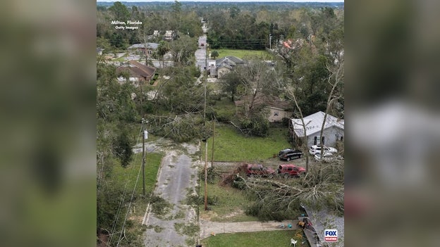
Hurricane Isaias leaves trail of damage in Milton, Florida. Credit: Getty Images.
Across the state, there are currently over 370,000 customers without power, according to data from poweroutage.com, 291,000 of which are FPL customers.
High winds, heavy rain and storm surge caused extensive damage in some of the hardest-hit communities.
Fallen trees and debris are blocking access in some areas, making restoration efforts more complex and time-consuming.
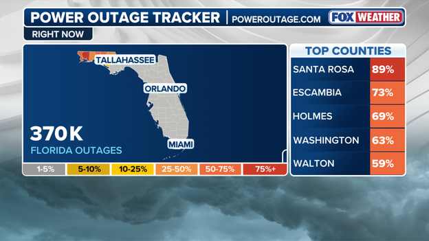
Florida Power Outages
Some homes and businesses may have sustained damage that makes it unsafe to receive power. Those customers must contact a licensed electrician to complete repairs before FPL can safely restore service.
Pensacola was among the areas hardest hit by Hurricane Isaias, with widespread damage reported across the Florida Panhandle.
The FOX Flight Team surveyed the storm’s impacts from above, capturing an aerial look at damaged homes, businesses and infrastructure in the Pensacola area.
The videos show the scale of destruction left behind as communities begin assessing the damage and starting the recovery process.
The Florida State Guard is assisting with search and rescue operations and flood recovery efforts in the aftermath of Hurricane Isaias.
According to the agency, air, ground and maritime units joined forces Saturday with the Florida Highway Patrol and Walton County Sheriff's Office to help communities impacted by the storm.
Crews deployed amphibious rescue vehicles, specialized rescue teams, manned aircraft and drones to support operations in flooded areas as recovery efforts continue across the Florida Panhandle.
As communities across the Florida Gulf Coast and North Florida begin recovering from Hurricane Isaias, specialized search-and-rescue crews are arriving to help assess damage, identify hazards and support local emergency responders.
Miami-Dade Fire Rescue’s Urban Search and Rescue Florida Task Force 1 is among the teams assisting in the storm’s aftermath.
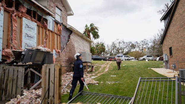
Credit: Miami-Dade Fire Rescue
The 88-member team includes four canine teams trained to support search-and-rescue operations in disaster zones.
The task force departed Miami-Dade on Oct. 9 and traveled to Tallahassee, where members met with Florida Chief Financial Officer Blaise Ingoglia, Florida Division of State Fire Marshal Director JoAnne Rice and other state leaders for a briefing on the storm’s impacts and their assignments.
From Tallahassee, the team continued to Molino in Escambia County, arriving shortly before Isaias made landfall.
Once conditions improved, task force members began surveying impacted areas, assessing potential hazards and assisting local agencies with response efforts.
The team remains deployed in North Florida and is prepared to provide specialized search-and-rescue, medical and disaster-response support wherever it is needed.
As the remnants of Hurricane Isaias push farther inland, FEMA is urging residents across impacted communities to remain cautious of lingering storm hazards.
The agency reminded residents to follow guidance from local officials, check on neighbors and stay away from floodwaters as the storm system continues moving through the Southeast.
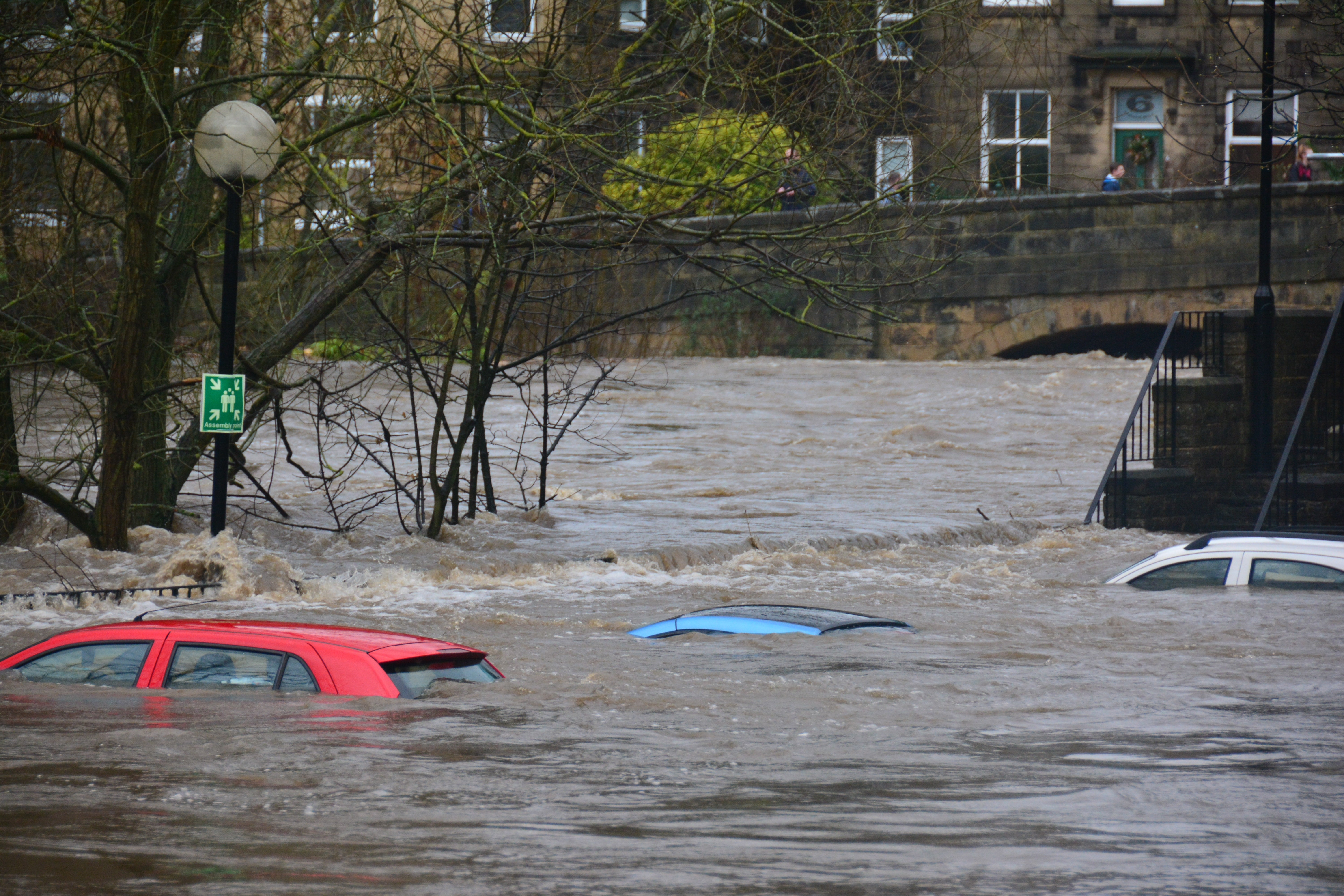
Officials emphasized that taking simple precautions can help protect families and communities as dangerous conditions persist even after the worst of the storm has passed.
Hurricane Isaias knocked out power to hundreds of thousands of customers across Florida, Alabama and Georgia as destructive winds, heavy rain and flooding battered the Gulf Coast.
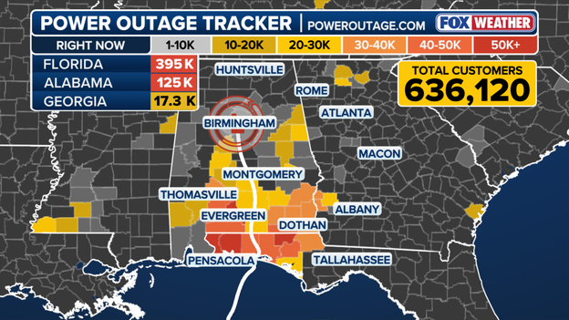
Power Outage Tracker using data from poweroutage.com
The latest outage tracker shows the greatest concentration of outages in Florida and Alabama, where downed trees and power lines are creating dangerous and difficult conditions for utility crews.
According to data from poweroutage.com, more than 395,000 customers are without power in Florida, while outages top 125,000 in Alabama as crews assess damage and work to restore service as conditions improve.
Residents should avoid downed power lines, which may remain energized, and stay off flooded roads while cleanup and recovery efforts continue.
Hurricane Isaias’ powerful landfall produced wind gusts of more than 115 mph across Florida, with a 118-mph gust recorded in Jay, according to a review of NWS storm reports by the FOX Forecast Center.
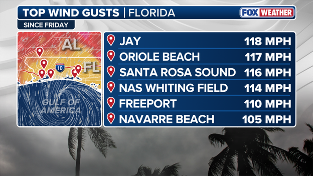
Top wind totals from Hurricane Isaias.
Oriole Beach recorded a 117-mph gust, followed by 116 mph at Santa Rosa Sound and 114 mph at Naval Air Station Whiting Field. Freeport also recorded a 110-mph gust as Isaias moved across the Florida Panhandle.
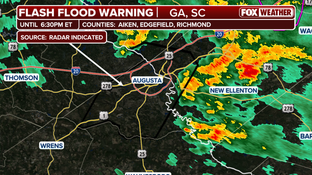
Flash Flood Warning in effect for parts of Georgia and South Carolina.
A Flash Flood Warning is in effect for portions of Georgia and South Carolina as heavy rainfall associated with Isaias continues to threaten communities across the Southeast.
The National Weather Service issued the warning at 4:36 p.m. EDT Saturday for portions of Burke, Columbia and Richmond counties in Georgia, along with Aiken and Edgefield counties in South Carolina. The warning remains in effect until 6:30 p.m. EDT.
Forecasters said 2 to 3 inches of rain have already fallen, with another 1 to 3 inches possible in the warned areas.
A tornado was also spotted Saturday night, but the warning has since expired.
The National Weather Service warned motorists not to drive through flooded roads or around barricades as dangerous flash flooding develops.
Hurricane Isaias’ destructive path has threatened more than lives and property, leaving wildlife and habitats vulnerable across Florida.
Storm surge and floodwaters can push manatees into shallow areas, canals, ponds and other locations where they may become stranded as water levels recede.
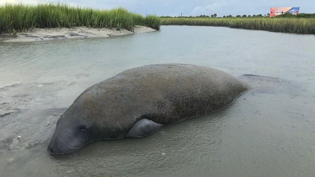
File photo. Credit: Florida Wildlife Conservation.
Florida wildlife officials are urging residents to avoid handling stranded, injured or dead manatees found after Hurricane Isaias and to report them to authorities instead.
The Florida Fish and Wildlife Conservation Commission said public safety remains its top priority before, during and after hurricanes and tropical storms.
Anyone who encounters a manatee in distress should keep their distance and call the FWC Wildlife Alert Hotline at 888-404-3922. Residents should not attempt a wildlife rescue if doing so could place them in danger.
The FWC is working with partners across Florida to assess and address the storm’s impacts on wildlife populations and habitats.
Dramatic video captured west of Woods Crossroads, South Carolina, shows a tornado crossing Highway 301 as severe weather associated with Isaias sweeps across the Southeast.
The close-range footage captures the dangerous storm moving across the roadway, highlighting the ongoing tornado threat as Isaias pushes farther inland.
Hurricane Isaias washed out a section of road at Grayton Beach State Park in Florida, offering an early look at the storm’s damage along the Gulf Coast.
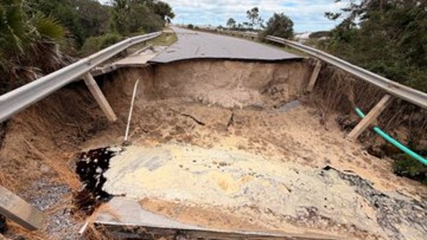
Hurricane Isaias damage at Grayton Beach State Park.
Florida State Parks staff were surveying parks across the state Saturday to assess damage from the hurricane and identify repairs needed before reopening.
Officials said the early assessments will help crews restore access and return the parks to visitors as quickly as possible.
The damage at Grayton Beach is one of the latest signs of Isaias’ impact along the Florida Panhandle, where powerful winds, heavy rain and storm surge battered coastal communities.
Hurricane Isaias forced the closure of at least 35 Florida state parks and associated overnight accommodations on Saturday across the Panhandle and Big Bend, as officials assess damage, clear debris and work to restore safe access.
For the latest information and a complete list of park closures, click here.
The flash flooding threat continues across the Southeast as post-tropical Cyclone Isaias moves through Alabama and toward the Southern Appalachians.
As of the 4 p.m. CDT (5 p.m. ET) advisory Saturday from the National Weather Service Weather Prediction Center, Isaias was located about 5 miles west of Birmingham, Alabama.
The system was moving northeast at 15 mph with maximum sustained winds of 30 mph and a minimum central pressure of 1007 millibars.
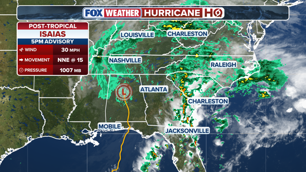
Weather Prediction Center 5 p.m. ET advisory.
Despite losing its tropical characteristics, Isaias continues to produce heavy rain capable of triggering flash flooding across portions of the Southeast and Southern Appalachians.
The system is moving northeast at a steady pace, but additional rainfall could worsen flooding, especially in areas that have already received significant rain or where streams and rivers are elevated.
Flood Watches remain in effect for portions of the Southeast United States and Southern Appalachians.
A High Wind Warning is in effect for portions of the Southern Appalachians, while Wind Advisories cover portions of the Mid-South and Southern Appalachians.
Isaias was located about 180 miles south of Nashville, Tennessee, as of the latest advisory.
The post-tropical cyclone is expected to continue tracking northeast through the Southeast and Southern Appalachians, bringing the threat of heavy rain, flash flooding and gusty winds along its path.
Dramatic video captured near Woods Crossroads, South Carolina, shows FOX Weather Exclusive Storm Tracker Brandon Copic's close-range encounter with a tornado as severe weather threatens the region.
The footage offers a striking look at the dangerous conditions unfolding across the Southeast as the region deals with storms associated with Isaias.
A confirmed tornado was reported Saturday afternoon in Allendale County, South Carolina, as severe thunderstorms moved through the region.
The National Weather Service in Charleston said the tornado was located over Appleton at 4:27 p.m. EDT and was moving north at 25 mph.
FOX Weather Exclusive Storm Tracker Brandon Copic is on the scene tracking severe storms across the Southeast.
The remnants of Isaias are supplying deep tropical moisture to the region, helping fuel slow-moving supercell thunderstorms capable of producing additional tornadoes.
A Tornado Watch is in place until 8 p.m. ET Saturday for portions of southeast Georgia and southeast South Carolina, including Allendale County, as severe thunderstorms capable of producing tornadoes moved through the region.
Hurricane Isaias left behind significant damage in Milton, Florida, after powerful winds battered the Gulf Coast Friday night. FOX News Correspondent Brandy Campbell reports from an apartment building that sustained major roof damage as the hurricane tore through the area.
The destruction is among the impacts being documented across the Florida Panhandle as residents begin assessing the damage left behind by Isaias.
Extensive damage is being reported in Pensacola, Florida, after Hurricane Isaias slammed the Gulf Coast Friday night with wind gusts topping 100 mph.
FOX Weather Correspondent Brandy Campbell surveyed the destruction, including an inn that had its roof torn off by the powerful winds.
The damage highlights the force of the hurricane as communities across the Florida Panhandle begin assessing the destruction and cleaning up in the storm's aftermath.
Thousands of additional utility workers are helping restore power across Alabama after Hurricane Isaias battered the Gulf Coast, leaving residents dealing with storm-related outages.
Alabama Power said 6,400 additional personnel from 25 states are working alongside its crews to restore electricity as quickly and safely as possible.
The utility said restoration efforts are ongoing and urged customers to check its outage map for the latest updates on power restoration.
The cleanup and recovery process is underway along Florida's Gulf Coast after Hurricane Isaias made landfall as a powerful Category 2 storm, leaving behind widespread damage.
FOX Weather Senior Correspondent Robert Ray captured video showing the aftermath in Pensacola Beach, Florida, where residents and emergency crews are beginning to assess the destruction left behind by the hurricane.
FOX Weather will continue providing live coverage throughout the weekend as communities across the Gulf Coast begin the long road to recovery.
As communities across Florida begin recovering from Hurricane Isaias, state officials are urging residents to remain cautious of lingering storm hazards.
Officials warned residents to avoid walking or driving through flooded areas and stay away from downed power lines, which can remain dangerous even after the storm has passed.
Residents who encounter injured wildlife are encouraged to contact Florida's 24-hour Wildlife Alert Hotline at 888-404-3922.
Additional recovery resources are available through the Florida Division of Emergency Management.
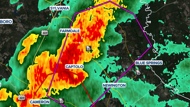
Confirmed tornado warning in Georgia.
The National Weather Service issued a Tornado Warning for portions of Screven County in southeastern Georgia Saturday afternoon as the remnants of Hurricane Isaias continue to threaten the Southeast.
The warning was issued after radar detected rotation in a severe thunderstorm, and will remain in effect until 3:15 p.m. EDT.
Forecasters warned that flying debris, damage to homes and vehicles, and downed trees are possible. The warning comes as Isaias continues to bring heavy rain, damaging wind gusts and the threat of additional tornadoes across Georgia and the Carolinas.
Florida Governor Ron DeSantis and state leaders provided a comprehensive recovery update on FOX Weather Saturday afternoon, confirming that despite Isaias' violent winds, most structures held up well.
Crews are working to clear away downed trees and restore power right now, and more than 10,000 customers have already gotten power back.
Essential supply chains are rebounding quickly with most grocery stores, gas stations, and home improvement retailers reopened, and impacted business owners can access damage assessment resources via Florida Disaster Business Portal.
Transportation Secretary Jared Perdue noted that while primary arteries I-10 and U.S. 98 are clear, 16,000 linemen are battling tree debris tangled in lines, and rising rivers present an ongoing inland flood threat where standing water must be avoided.
State Chief Financial Officer Blaise Ingoglia also issued a stark consumer warning regarding reports of price gouging, advising residents to thoroughly verify contractor credentials before signing contracts or paying deposits.
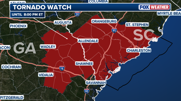
Tornado Watch for parts of Georgia and South Carolina until 8 p.m. ET Saturday
The Storm Prediction Center has issued a Tornado Watch for eastern Georgia and parts of South Carolina, effective until 8 p.m. ET today.
The remnants of Isaias are producing strong atmospheric shear, boosting the potential for quick spin-up tornadoes and localized damaging wind gusts.
Residents in the watch area should keep mobile alerts turned on and be ready to seek shelter immediately if warnings are issued.
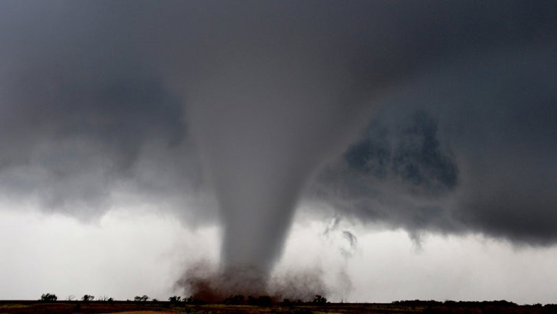
Post-Tropical Isaias is leaving behind a path of devastation after making landfall Friday night in Destin, Florida.
FOX Weather Senior Correspondent Robert Ray is on the ground in Pensacola Beach, Florida, with the latest on the damage and his experience covering the landfall.
Escambia County Sheriff Chip Simmons has confirmed another storm-related death following a heartbreaking generator accident inside a home.
Deputies called to the residence found a man dead and four other people inside the home. The group had been running a generator indoors without proper ventilation.
All four survivors were rushed to the hospital and are being treated for carbon monoxide poisoning.
Sheriff Simmons says while deputies were working the scene, they noticed the house right next door was also running a generator inside without ventilation and stepped in immediately to stop it.
Sheriff Simmons is pleading with anyone still without power: never operate a generator inside your house, garage, or anywhere near open windows. Exhaust needs to be pointed far away from living spaces.
This latest tragedy brings the total death toll from Isaias to four across Florida and Alabama.
In the wake of Hurricane Isaias, Pensacola State College has announced that all campus locations will remain closed on Sunday, Oct. 11, and Monday, Oct. 12.
The extended closure comes as local utility crews work to address extensive power outages and emergency personnel clear fallen trees and debris across Escambia and Santa Rosa counties.
College administration says it is continuing to monitor campus conditions and restoration progress.
Striking video shared by the Dale County Sheriff's Office highlights the extreme danger facing first responders and utility crews as they addressed widespread reports of fallen trees, blocked roadways, and downed power lines across the county overnight.
Emergency personnel are working around the clock to clear hazards and restore safe travel conditions, but officials warn that roads remain treacherous.

Dale County Sheriff's Office/Facebook
A sheriff's deputy suffered minor injuries last night when a tree came crashing down on a vehicle while trying to help others.
We've learned the deputy was treated for minor injuries and is back home recovering with family.
The Sheriff's Office extends its gratitude to the community for their support and prayers while urging all residents to avoid unnecessary travel.

City of Tallahassee, Fl - Government/Facebook
Tallahassee International Airport (TLH) remains open and fully operational, serving a critical dual role as both an active flight hub and a major statewide logistical staging area in the wake of Hurricane Isaias.
The airport grounds are currently hosting multi-agency relief operations, with the Florida National Guard, State EOC, Florida State Guard, and AT&T Disaster Services staging aircraft, heavy machinery, and emergency equipment on-site.
Operating from TLH allows these first-response entities to rapidly deploy personnel and vital recovery assets across the hard-hit Florida Panhandle.
Passengers planning commercial travel are still advised to check flight status with their airlines as relief operations proceed alongside standard operations.
Rain from Isaias has forced NASCAR officials to postpone all on-track activities scheduled for today at Charlotte Motor Speedway in Concord, North Carolina.
Continuous downpours across the region led officials to cancel Saturday's practice and qualifying sessions along with the scheduled lower-series race.
The postponed event has been rescheduled to run Sunday evening following the conclusion of the main Cup Series event.
Power restoration efforts are making steady progress across the South, with total customer outages dropping below 790,000 as utility crews work around the clock.
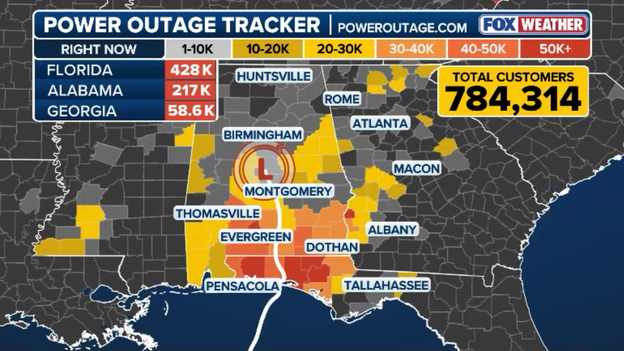
Latest power outage numbers from PowerOutage.com
That marks a significant reduction from peak outage numbers nearing 950,000 customers shortly after Hurricane Isaias made landfall.
Florida continues to bear the brunt of the power grid damage, with approximately 428,000 customers still without electricity.
Line workers, tree-trimming crews, and heavy equipment operators are actively clearing fallen limbs, replacing snapped utility poles, and repairing severed distribution lines across the Panhandle to restore power as quickly and safely as possible.
Cleanup and damage assessment operations are officially under way along Florida's Gulf Coast following Isaias' landfall as a powerful Category 2 hurricane.
Video captured by FOX Weather Senior Correspondent Robert Ray on the ground in Pensacola Beach reveals the full extent of the storm's impact, showing sand-choked roads, structural roof damage, downed signs, and scattered debris across the barrier island.
Alabama Governor Kay Ivey just a statement addressing the severe impacts of Hurricane Isaias across the state, confirming that two Alabamians have tragically lost their lives due to the storm's powerful winds.
Expressing her prayers for the victims' families, Gov. Ivey emphasized that state and local teams are working tirelessly to clear debris and restore electricity.
Fellow Alabamians, please continue being smart today as cleanup continues. Safety for y’all is the main thing today.
Gov. Ivey reported that all major state roadways, including the Intracoastal Waterway (ICW), have been cleared and reopened.
However, some localized closures remain due to downed power lines and trees—such as a section of U.S. 31 north of Brewton in Escambia County—where utility linemen and road crews are actively working to restore access as quickly as possible.
This tragic loss brings the total to three confirmed storm-related fatalities attributed to Isaias across the region, following the earlier report of a woman killed when a tree fell on her home in Florida.
Transportation infrastructure across Florida's Panhandle took a major step forward early this morning as emergency crews successfully cleared and reopened all state bridges, along with critical arterial highways including Interstate 10 and U.S. 98, prior to daylight.
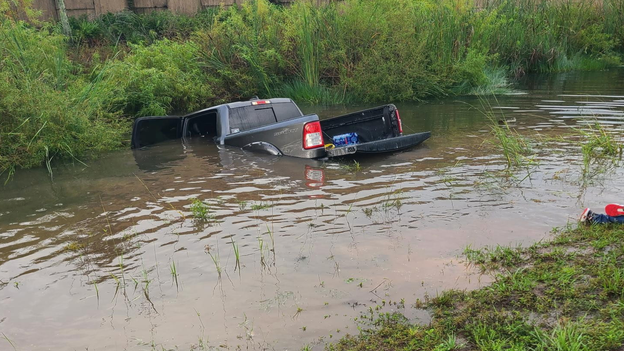
@FLGuard/X
In a dramatic life-saving rescue following Hurricane Isaias, Florida National Guard Soldiers with Delta Battery, 3rd Battalion, 265th Air Defense Artillery Regiment sprang into action after spotting a vehicle submerged in a roadside ditch.
While en route from Tallahassee, the Guardsmen noticed the crashed vehicle trapped in high floodwaters along the road.
Without hesitation, the Soldiers pulled over, swam through the rushing water to reach the submerged car, and successfully pulled its occupants to safety.
The heroic action highlights the hidden dangers lingering on flood-damaged roadways and the crucial role first responders and National Guard units are playing across the state in the immediate aftermath of the storm.
If you're waking up to gray skies anywhere across the eastern third of the United States today, you have Isaias to thank.
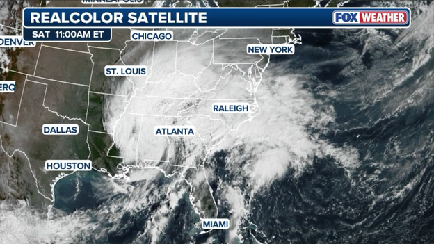
GOES-East satellite image showing an expansive cloud shield across the East from Isaias
High-resolution GOES satellite imagery reveals a massive, continuous cloud shield associated with the storm, stretching over 1,500 miles from the Midwest and Ohio Valley far out into the open Atlantic Ocean.
While the Atlantic basin goes quiet in the immediate aftermath of Hurricane Isaias, the FOX Forecast Center is keeping a close eye on the long-range horizon.
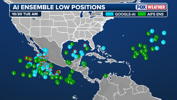
AI models hint at potential tropical development in the Gulf or Western Caribbean in 10-14 days
Several long-range AI models are beginning to hint at potential tropical development in the Gulf of America or western Caribbean in about 10-14 days' time.
There are no immediate threats, but this region becomes a classic area of interest during this phase of the season as a broad low-pressure system, known as the Central American Gyre, often spins off tropical disturbances.
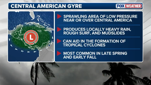
The Central American Gyre can help spin up tropical systems
Adding to the setup, a favorable phase of the Madden-Julian Oscillation (MJO) is projected to sweep across the Western Hemisphere in the coming weeks, providing enhanced upward motion and atmospheric lift across the tropics.
It is worth adding a quick caveat regarding these long-range signals: AI forecast models have struggled this season with initial tropical storm formation, often generating spurious low-pressure systems or over-initiating weak tropical disturbances before a distinct center exists.
However, the broader atmospheric setup—a broad Central American Gyre paired with a favorable MJO phase—presents a broad-scale pattern we are very familiar with and bears watching.
FOX News Senior Correspondent Jonathan Serrie is live in Panama City Beach, Florida, tracking recovery operations as emergency crews and residents assess damage in the wake of Hurricane Isaias.
A second death linked to Hurricane Isaias has been confirmed in the Florida Panhandle.
Escambia County Sheriff Chip Simmons announced on social media that a woman was killed when a large tree collapsed onto a residential home during the storm.
Sheriff Simmons expressed deep condolences to the victim's family as deputies and emergency personnel continue working across the county.
This marks the second storm-related death, following an earlier fatality reported in Birmingham, Alabama, as water-logged soils and lingering wind gusts continue to knock down mature trees across the region.
Utility crews across the South are making quick progress in bringing the power grid back online following Hurricane Isaias.
Outage totals have dropped to approximately 889,000 customer accounts, down from a peak of nearly 940,000 earlier this morning when over 1 million people were left in the dark.
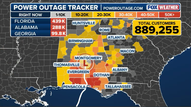
Latest power outage data from PowerOutage.com
Despite these early gains, power companies warn that full restoration will be a slow, painstaking process.
Massive uprooted trees, snapped distribution poles, and scattered debris continue to block access routes and complicate repairs.
Line crews and bucket trucks are working systematically to clear hazards, but complete power restoration in the hardest-hit inland and coastal communities is expected to take days.
A multi-basin tropical triple threat is unfolding as moisture from three separate systems—Isaias in the East alongside Pacific systems Rachel and Simon—prepares to deliver prolific rain across large swaths of the country over the coming days.
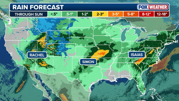
A trio of tropical systems will pump moisture into the U.S. over the coming days
While Isaias pushes a deep plume of tropical moisture up through the Eastern Seaboard, Pacific storms Rachel and Simon are funneling rich atmospheric moisture into the West and Southern Plains.
The combination of these active storm tracks will unleash tropical downpours, widespread 2-to-5+ inch rain totals, and heightened flash flood risks stretching from the Appalachians to the Ohio Valley and across parts of the western terrain.
As the remnants of Isaias push deeper inland today, a significant flash flooding threat is expanding across the eastern half of the country, with tropical moisture encountering the higher terrain of the interior.
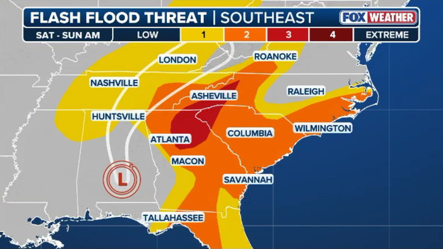
Flash flooding is expected well north and east of where Isaias made landfall on Friday night
The FOX Forecast Center is closely monitoring an elevated flash flood threat extending from North Georgia into the steep mountain topography of Western North Carolina.
Torrential rain rates of 2 to 4 inches per hour within tropical rainbands will rapidly fill creeks, streams, and low-lying roadways.
In the high terrain of the Southern Appalachians, saturated soils combined with heavy rain also heighten the risk of dangerous mudslides and landslides.
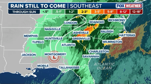
Latest rain forecast from FOX Weather calls for nearly half of foot of rain to fall in some areas
Residents in low-lying areas and mountain valleys should remain hyper-vigilant, monitor local flood watches, and never attempt to drive through flooded roads or low-water crossings.
The reach of Hurricane Isaias’ destructive winds was felt as far inland as Birmingham, Alabama, where the Emergency Management Agency (EMA) director has confirmed one fatality after a tree crashed onto a residential home.
According to officials, the massive tree struck the house overnight, leaving multiple people trapped inside as emergency crews rushed to the scene.
The incident underscores the severe ongoing hazards posed by saturated soil and lingering wind gusts, which continue to weaken root systems and bring down trees across the South.
Emergency responders urge residents to remain cautious when stepping outside, avoid damaged structures, and stay clear of heavy tree canopies where compromised limbs could still fall.

Exclusive analysis from FOX Weather Hurricane Specialist Bryan Norcross
FOX Weather Hurricane Specialist Bryan Norcross provided an exclusive post-landfall analysis highlighting how cutting-edge machine learning technology helped solve one of the most complex forecasting challenges of Hurricane Isaias.
Sorting out how Isaias's interaction with the jet stream was going to affect the storm track was a major challenge in forecasting the hurricane.
The AI computer forecast models kept predicting a track on the right side of the cone – farther east.
In the end, the Google DeepMind AI forecast was once again the best. The new machine learning models continue to amaze, especially for developed systems with an identifiable center.
While Hurricane Isaias delivered a punishing blow with 110+ mph wind gusts and over 5 feet of storm surge, atmospheric conditions in the final hours before landfall prevented an even more catastrophic scenario along the Florida Panhandle.
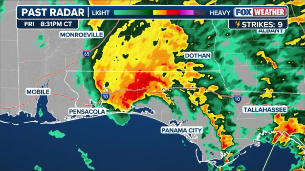
Radar image showing the lopsided center of Hurricane Isaias as it made landfall near Destin, FL at 9:30 p.m. ET on Friday
Strong upper-level wind shear tilted the storm's vertical structure, disrupting the eyewall and ripping the tight inner core apart just as the center approached Destin.
Hurricanes rely on a highly organized, symmetric eyewall to act as an engine, concentrating its most destructive winds right at the center.
When persistent wind shear injected drier air and detached the upper-level outflow from the low-level circulation, the storm was prevented from undergoing rapid intensification right at the coastline.
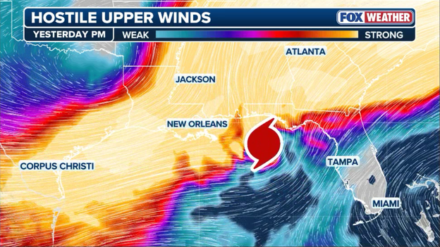
Hostile winds (wind shear) began to influence Hurricane Isaias on Friday afternoon ahead of landfall
While this shear expanded the field of tropical-storm-force winds across a broader area, it successfully capped peak eyewall wind speeds from escalating to catastrophic levels prior to landfall.
As daylight approached following Hurricane Isaias’ Friday night landfall, early damage assessment and cleanup operations were already getting underway in Panama City Beach.
FOX News Senior Correspondent Jonathan Serrie reported live before sunrise on riding out the core of the storm along the coast.

Latest power outage tracker from PowerOutage.com
Power outage totals have escalated dramatically across the South as Hurricane Isaias pushes deeper inland, leaving over 929,000 total utility customer accounts without electricity according to PowerOutage.com.
Because a single utility "customer" represents an entire household or business address, we can estimate that well over 1,000,000 individual Americans are currently sitting in the dark right now.
Florida Governor Ron DeSantis joined FOX & Friends this morning to detail state recovery operations following Hurricane Isaias’ landfall as a strong Category 2 system.
During the interview, DeSantis urged Floridians across the Panhandle and northern Florida to remain extremely cautious on local roads, warning that downed trees, fallen power lines, and storm debris continue to create significant hazards.
FEMA Region 4 Administrator Rob Ashe is on-site at the State Emergency Operations Center in Tallahassee alongside leadership from the Florida Division of Emergency Management (FDEM).

@FLSERT/X
Teams are coordinating the deployment of disaster staging assets, emergency supplies, and response personnel across impacted Panhandle communities.
Joint state and federal emergency response operations remain focused on real-time relief efforts and critical infrastructure support as recovery ramps up.
Officials say pre-positioned teams are already starting ground-level disaster assessments and resource distribution now that conditions have improved.

@FLSERT/X
As Hurricane Isaias’ violent eyewall swept through the Florida Panhandle, weather stations across the region captured staggering wind speeds, topping out well over 100 mph.
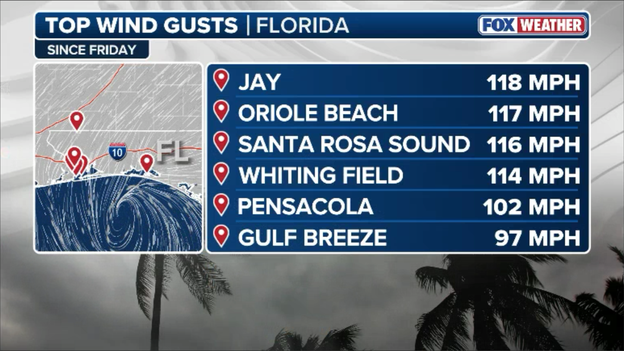
Peak wind gusts recorded from Hurricane Isaias
The terrifying 118 mph peak gust recorded near Jay—located further inland near the Alabama border—highlights the destructive power the storm maintained even as its core moved over land.
These ferocious, tree-snapping winds are responsible for the widespread structural damage, shattered roofs, and massive power outages impacting hundreds of thousands of residents.
As Isaias pushes deeper inland, its wind field is expanding significantly, spreading gusty winds far north of where it came ashore.
Weather observation stations are currently reporting wind gusts near 30 mph stretching from Chattanooga, Tennessee, through Gainesville, Georgia, and across into Greenville, South Carolina.
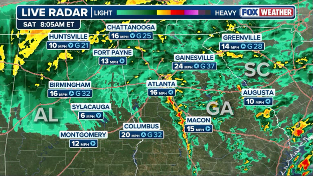
Map showing rain falling across the Southeast with gusty winds as Isaias moves north
Even though the storm’s core is weakening as it interacts with land, the tight pressure gradient surrounding the system is driving breezy to squally conditions well into the Southern Appalachians and Piedmont regions.
With saturated soil conditions moving into the area, these 30 mph gusts can easily knock down weak tree limbs and cause scattered power outages throughout the morning.
As Isaias continues to move inland and weaken, the rest of the Atlantic basin is going quiet again.
According to the latest update from the National Hurricane Center, tropical cyclone formation is not expected across the North Atlantic, Caribbean Sea, or Gulf of America over the next week.
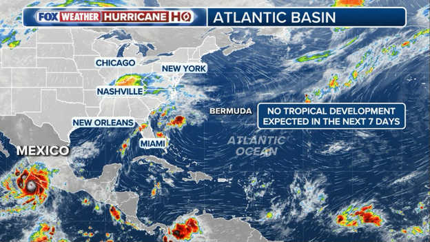
No tropical development is expected in the Atlantic Basin over the next 7 days
Strong upper-level winds and stable atmospheric conditions thanks to El Niño are sweeping across the basin again, suppressing new tropical organization for the foreseeable future.
FOX Weather will continue monitoring long-range atmospheric patterns as the season winds down to its official end on November 30, but meteorologists anticipate a peaceful 7-day window across the entire Atlantic basin.
Alabama state agencies issued a joint update following Isaias' landfall. Governor Kay Ivey was joined by the state's Emergency Management Agency, Law Enforcement Agency, Department of Transportation and Department of Public Health when they released their update at 6:00 a.m. CT.
"Right now, we are worried about strong winds, heavy rain and possible spinoff tornadoes in certain parts of the state. As we approach the weekend and any travel plans, make sure you have reliable information as conditions develop. We often hear in emergency management: Hope for the best. Prepare for the worst. That is the approach we need with this particular storm system. After all, we only want to see one Tide roll this weekend. Y’all be safe, heed local warnings and stay weather aware."
The Governor's Office of Volunteer Services said "Alabama Governor’s Emergency Relief Fund (GERF) supports the unmet needs of families and individuals working to recover from disasters in our state."
Alabama Emergency Management Agency warns that the heaviest rain and strongest winds will push northward through central Alabama, while the Law Enforcement Agency is telling drivers to avoid unnecessary travel.
Alabama's Department of Transportation listed the below road closures:
• US-80 near Marler Road (Pike Road) – power lines
• US-82 near CR-40 (Autauga County) – power lines
• US-231 near Bethlehem Rd (Elmore County) – tree blocking roadway

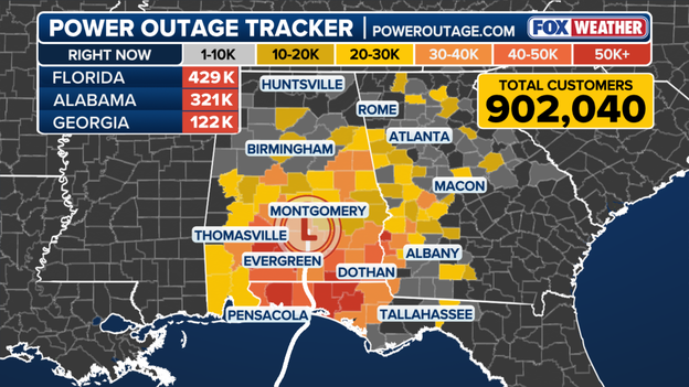
Power Outages
More than 900,000 customers are without power across the Southeast early Saturday as post-topical Isaias barrels its way inland.
The majority of outages are concentrated across the Florida Panhandle and southern Alabama but outages are also mounting in western Georgia.
Officials and neighbors in coastal communities along the Florida Panhandle are just beginning to get a sense of the damage left behind by Hurricane Isaias.
Fox News Correspondent Caroline Elliott is LIVE in Navarre Beach, Florida, close to where the storm made landfall.
FOX Weather Senior Correspondent Robert Ray reported widespread power outages, downed trees and debris, and flash flooding across Okaloosa and Escambia counties early Saturday.
Post-tropical Isaias is tracking over central Alabama and slamming much of the Southeast with heavy rain, even as the storm’s sustained winds have weakened.
Rain is now spreading as far north as Tennessee and North Carolina.
The National Hurricane Center warned that "considerable flash flooding and landslides" are possible across the Southern Appalachians.
The storm will soak the Southeast through Saturday before Isaias' moisture reaches the Northeast and the Interstate 95 corridor Sunday.
What you missed
FOX Weather Meteorologists Britta Merwin and Craig Herrera are here for you, part of a second day of 24-hour storm coverage as the Isaias' remnants fuel a dangerous flash flood and tornado threat across the Southeast.
Our FOX Weather field team is fanned out across the region, from the Florida Panhandle to Birmingham, Alabama, and Atlanta.
A FOX Weather viewer submitted this video of pine trees snapped in half around his home in Jay, Florida, near the Alabama border. Fortunately, his home and vehicles did not sustain major damage. A 118-mph wind gust was recorded nearby, the strongest gust associated with Hurricane Isaias so far.
Bellwood, Alabama, and Defuniak Springs, Florida, have seen more than a foot of rain from Hurricane Isaias as the storm's remnants fuel a dangerous flash flood threat across the region Saturday.
A Level 3 of 4 flood risk has been issued for Saturday across parts of northern Georgia and the Blue Ridge Mountains, including the Atlanta and Asheville, North Carolina, metro areas.
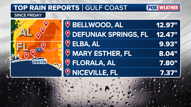
Top Rain Reports
Rain from the remnants of Hurricane Isaias has reached Birmingham, Alabama, with the worst of the winds still to come. Gusts of up to 60 mph are expected in the Birmingham metro area. FOX News multimedia reporter Asher Redd has the latest conditions.
FOX Weather Senior Correspondent Robert Ray reports between 2 and 3 feet of flooding in Fort Walton Beach, Florida, just a few hours after Hurricane Isaias slammed the coast with hours of intense wind and rain.
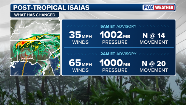
The National Hurricane Center (NHC) said Isaias has become post-tropical in its latest advisory, issued at 2 a.m. ET, meaning that it has lost its tropical characteristics and is no longer being fueled primarily by warm ocean water.
However, the storm's impacts are far from over.
The remnants of Isaias are producing heavy rain across Alabama and Georgia, while a dangerous tornado threat remains across parts of the Florida Panhandle, Georgia and South Carolina.
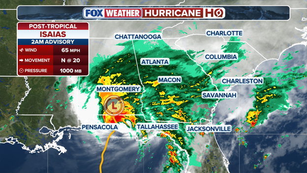
Isaias becomes post-tropical
More than 760,000 customers across the Southeast are without power as Hurricane Isaias moves inland with sustained winds of 90 mph. Most outages are concentrated in the Florida Panhandle, where Isaias made landfall, but outages are also mounting across southern Alabama and southwestern Georgia.
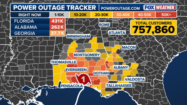
Latest Power Outage
FOX Weather Correspondent Brandy Campbell continues her coverage from Pensacola Beach, Florida, where intense conditions persist through the night, with strong wind gusts and heavy rainfall barreling through the region.
Check out the mesmerizing views from the Air Force Reserve Hurricane Hunters mission as they enter the storm to collect weather data, in the hours before the dangerous storm made landfall.
The worst of Hurricane Isaias has moved away from the Gulf Coast, allowing communities that avoided the storm’s most severe impacts like Orange Beach to begin cleanup and assess the damage.
On the Alabama Gulf Coast, crews are clearing debris and downed trees from the streets in Orange Beach as crews work to recover after the storm.
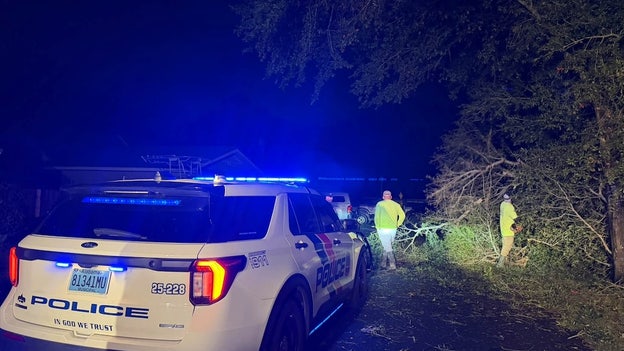
Cleanup and recovery efforts are underway in Orange Beach after Hurricane Isaias moved inland.
Orange Beach officials said damage across the city was minimal, with roads being checked and cleared ahead of a planned reopening Saturday morning.
Baldwin EMC crews are expected to begin addressing remaining outages at daybreak, as widespread power outages continue across the region, including more than 250,000 customers without power in Alabama alone.
President Donald Trump said he is monitoring Hurricane Isaias "very closely" as the powerful storm threatens the Gulf Coast.
Speaking to reporters after stepping off Marine One following a rally in New York, Trump said his administration is closely tracking the hurricane and expressed confidence that officials have the situation under control.
Trump has also approved federal emergency declarations for parts of Florida and Alabama, authorizing FEMA to assist with storm response efforts as dangerous conditions unfold across the region.
As Hurricane Isaias takes a toll on the utility grid across the Gulf Coast, Alabama Power has brought in 5,700 additional resources from 25 states to support restoration efforts as the storm moves into Alabama.
The utility said crews are staged and ready to respond to outages and begin restoring power as quickly and safely as conditions allow.
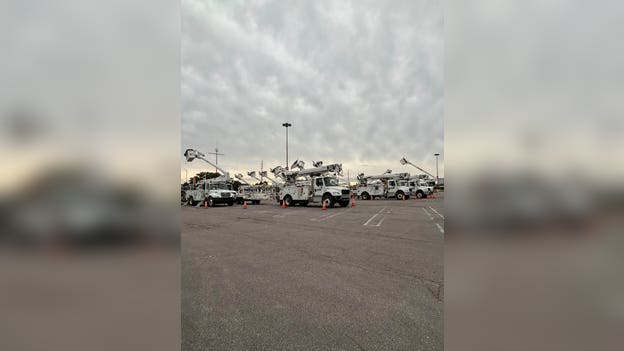
5,700 additional resources from 25 states are in Alabama to support crews, Alabama Power said.
Across the Southeast, particularly in Alabama and Florida, Hurricane Isaias’ impacts are being felt as more than 650,000 customers across the two states remain without power, according to data from poweroutage.com.
Residents across the storm zone should stay away from downed power lines, which may remain energized even if they appear inactive.
Downed lines should be reported to their utility provider and follow guidance from local officials as Isaias moves through the state.
Hurricane-force winds ripped the roof off the Rest and Relax Inn in Pensacola, Florida, as Hurricane Isaias battered the northern Gulf Coast.
Video captured from a nearby radio station shows the building’s roof being torn apart as powerful winds slammed the area.
The damage highlights the lasting toll Isaias’ hurricane-force winds inflicted across the Florida Panhandle.
More than a foot of rain has drenched DeFuniak Springs, Florida, as Hurricane Isaias unleashes torrential rainfall across the Gulf Coast.
The community recorded an astounding 12.46 inches of rain, according to the latest FOX Weather rainfall reports — more than an entire foot falling as Isaias moved through the region.
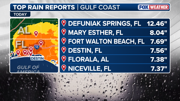
FOX Weather Top Rain Totals.
The extreme rainfall has fueled dangerous flash flooding, overwhelmed drainage systems and created hazardous conditions across northwest Florida, where the storm’s impacts continue even after weakening inland.
Although Hurricane Isaias has weakened to a Category 1 storm, its dangerous impacts continue to hammer the Gulf Coast.
FOX Weather Correspondent Brandy Campbell continues reporting from Pensacola Beach, Florida, where Isaias is still bringing powerful winds, torrential rain and flooding.
More than 600,000 customers across Florida, Alabama and Georgia are without power as Hurricane Isaias moves inland, with destructive winds knocking out electricity across the Gulf Coast and Southeast.
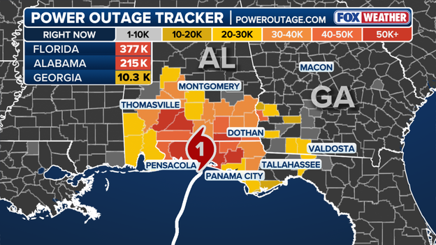
Power Outage Tracker using poweroutage.com.
The FOX Weather Power Outage Tracker shows over 375,000 outages in Florida, 215,000 in Alabama and over 10,000 in Georgia — more than 600,000 outages combined.
Powerful wind gusts, falling trees and downed power lines are leaving thousands without electricity as Isaias continues spreading heavy rain and dangerous winds farther inland.
The 11 p.m. ET (10 p.m. CDT) advisory from the National Hurricane Center shows Hurricane Isaias weakening to a Category 1 hurricane with maximum sustained winds of 90 mph as it moves inland across the Florida Panhandle.
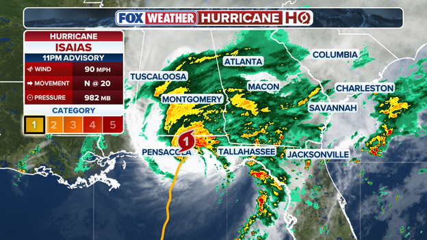
11 p.m. ET advisory from the National Hurricane Center
Located about 45 miles east-northeast of Pensacola and 65 miles northwest of Panama City, Isaias is moving north at 20 mph with a minimum central pressure of 982 mb.
The hurricane warning west of the Mississippi-Alabama border and the tropical storm warning west of Ocean Springs, Mississippi, have been discontinued.
A Storm Surge Warning remains in effect from Dauphin Island, Alabama, to the Suwannee River in Florida, as dangerous coastal flooding continues along the Gulf Coast.
Hurricane Isaias brought violent winds to the Florida Gulf Coast, with a 116-mph gust reported at Santa Rosa Sound as the dangerous Category 2 hurricane made landfall near Destin.
The extreme gust was the strongest reported along the coast as Isaias moved ashore Friday night.
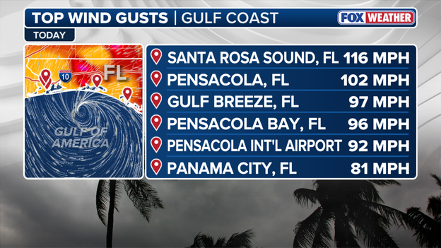
Top Wind Gusts
The worst of Isaias’ impacts were evident in the violent wind gusts tearing across the Florida Panhandle, with winds capable of toppling trees, ripping down power lines and causing widespread power outages across the Gulf Coast.
Hurricane Isaias’ dangerous impacts across the Gulf Coast have prompted the federal government to authorize emergency assistance for parts of Florida and Alabama as communities face damaging winds, storm surge, flash flooding and widespread power outages.
FEMA announced that federal disaster assistance is available to supplement state, tribal and local response efforts related to the emergency conditions caused by Isaias.

Credit: Getty Images
In Alabama, President Donald Trump also approved an emergency declaration covering Baldwin, Escambia and Mobile counties, as well as the Poarch Band of Creek Indians, unlocking federal support for emergency protective measures.
The presidential action authorizes FEMA to coordinate federal relief efforts and provide equipment and resources to help save lives, protect property and safeguard public health and safety.
FEMA is authorized to identify, mobilize and provide equipment and other resources needed to address the storm’s impacts. Emergency protective measures, limited to direct federal assistance, will receive 75% federal funding.
The 10 p.m. ET (9 p.m. CDT) update from the National Hurricane Center places Hurricane Isaias about 50 miles east of Pensacola and 50 miles west-northwest of Panama City, Florida.
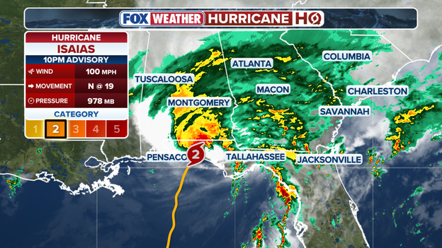
10 p.m. ET advisory from the National Hurricane Center
Isaias is maintaining Category 2 strength with maximum sustained winds of 100 mph and a minimum central pressure of 978 mb, as life-threatening storm surge impacts the Gulf Coast and dangerous hurricane conditions and flash flooding spread inland.
The hurricane is moving north at 19 mph, carrying dangerous winds, torrential rain and flash flooding farther inland.
Ahead of Hurricane Isaias’ landfall near Destin, FOX Weather crews were staged along Florida’s Gulf Coast, where powerful wind gusts sent sheets of rain sideways and offered an early glimpse of the storm’s dangerous conditions.
A rare Level 4/4 flash flood threat has been issued for parts of Florida and Georgia as Hurricane Isaias unleashes torrential rain across the Southeast, creating the potential for dangerous and life-threatening flooding.
The highest threat is focused across portions of the Florida Panhandle, the Big Bend and northern Florida, along with parts of southern Georgia and southeastern Alabama.
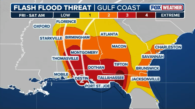
Flash Flood Threat.
The FOX Forecast Center warns that repeated bands of heavy rain could overwhelm drainage systems, rapidly flood roads and swell creeks and rivers, while Hurricane Isaias’ storm surge drives dangerous, life-threatening coastal flooding.
Tallahassee, Dothan, Tifton and Thomasville are among those inside or near the most serious risk zone.
The heaviest rain is expected from Friday into Saturday morning, as Isaias’ circulation pushes deep tropical moisture inland.
The Level 4 designation represents an extreme flash flood threat and is reserved for situations capable of producing widespread, significant and potentially life-threatening flooding.
Saturated ground from repeated rounds of rain prior to Isaias, intense rainfall rates and repeated thunderstorms could make conditions deteriorate quickly.
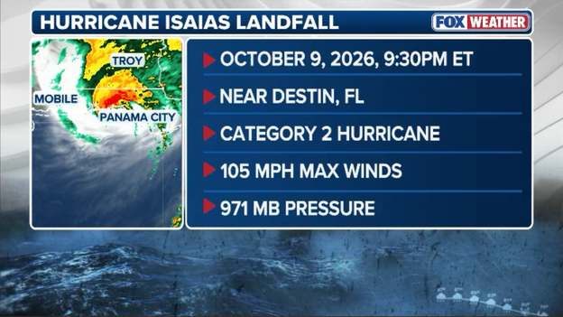
Hurricane Isaias made landfall around 9:30 p.m. ET Friday near Destin, Florida
Hurricane Isaias has officially made landfall near Destin, Florida, around 8:30 p.m. CT (9:30 p.m. ET), bringing maximum sustained winds of 105 mph and an estimated minimum central pressure of 971 mb.
Ferocious eyewall winds and life-threatening storm surge are pounding the coast as the storm pushes inland.
A station near Santa Rosa Sound recently clocked an astounding wind gust of 116 mph alongside sustained winds of 91 mph, while a WeatherSTEM station near Pensacola logged a 100 mph gust.
Meanwhile, water levels at Panama City Beach have surged to 5.6 feet above normal tide, driving severe coastal inundation into low-lying communities.
As dangerous hurricane-force winds and torrential flash flooding push further inland tonight, everyone in the path of the storm must remain sheltered in interior safe rooms until the storm passes.
The dangerous impacts of Hurricane Isaias are expand beyond hurricane-force winds, life-threatening storm surge and flooding, with a Tornado Watch now in effect across parts of Florida and southern Georgia.
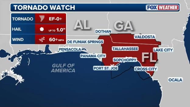
Tornado Watch
The tornado watch is in effect for more than 850,000 until 6 a.m. ET Saturday for portions of the Florida Panhandle, Big Bend and northern Florida, along with parts of southern Georgia.
The watch includes the possibility of a couple of tornadoes, hail up to 1.5 inches and wind gusts reaching 60 mph.
According to the FOX Forecast Center, tornadoes could develop quickly within Isaias’ outer and trailing rainbands as the hurricane moves inland.
The overnight tornado threat adds another dangerous layer to the crushing impacts Hurricane Isaias is unleashing across the Gulf Coast and Southeast.
FOX Weather Senior Correspondent Robert Ray is getting slammed by torrential rain and hurricane-force gusts in Destin, Florida, as Hurricane Isaias is making landfall along the Gulf Coast.
The area is under a Flash Flood Emergency through early Saturday morning.
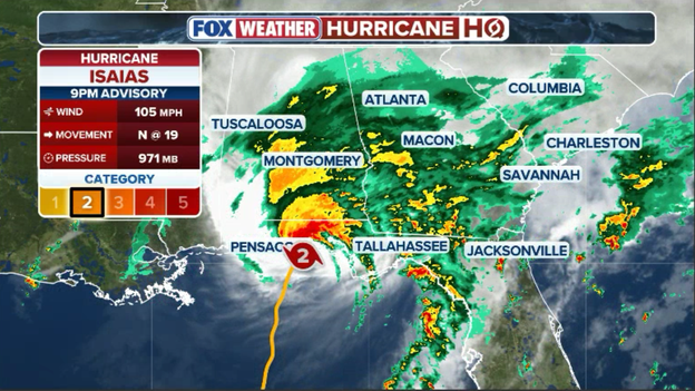
9 p.m. ET update from the National Hurricane Center
Water levels are rising rapidly along the Florida Panhandle as Hurricane Isaias moves onshore, bringing extreme storm surge and life-threatening flash flooding inland.
According to the National Hurricane Center’s 9 p.m. ET (8 p.m. CT) position update, a NOAA tide gauge at Panama City Beach recently recorded a staggering water level of 5.4 feet above normal tide.
Meanwhile, severe eyewall winds continue to hammer the region. Pensacola City Hall just logged a ferocious wind gust of 102 mph alongside sustained winds of 62 mph.
Isaias is holding onto maximum sustained winds of 105 mph and is moving north at 19 mph.
As the outer effects of Hurricane Isaias push well inland, Great Smoky Mountains National Park officials have announced immediate preventative closures to protect visitors.
U.S. 441/Newfound Gap Road closed at 8 p.m. due to expected high-altitude winds that pose a severe threat for falling trees and hazardous road debris.
Additionally, Balsam Mountain Campground closed earlier this evening at 5 p.m.
Park visitors in the region are urged to avoid high-elevation travel and stay updated on local mountain weather conditions as damaging wind gusts continue through the night.
Power outages are skyrocketing across the region as Hurricane Isaias brings violent eyewall winds onshore.
More than 303,000 customers are now without electricity in Florida, while blackouts in Alabama have quickly climbed past 115,000.
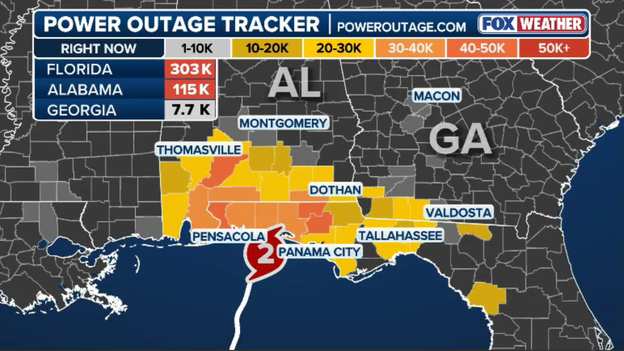
Latest power outage data from PowerOutage.com
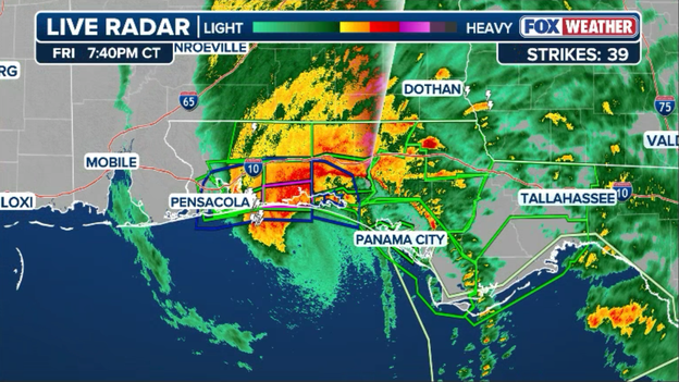
Radar showing the center of Hurricane Isaias beginning to move ashore
The center of Hurricane Isaias is crossing the coastline in the western Florida Panhandle, bringing the full force of its 110 mph core directly ashore.
Severe wind gusts, destructive storm surge, and torrential downpours are actively battering communities along the shoreline as the eyewall moves inland.
We are tracking the National Hurricane Center's updates as the storm's center moves completely over land.
We will bring you an update as soon as the NHC officially declares the precise landfall location and time.
Dramatic footage out of Destin, Florida, captures the destructive power of Hurricane Isaias’ incoming storm surge as massive, pounding waves crash onto the shoreline.
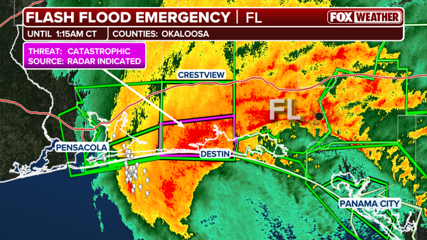
A Flash Flood Emergency is in effect for Okaloosa County, Florida.
Parts of Okaloosa County are under a catastrophic Flash Flood Emergency as Hurricane Isaias nears landfall.
Destin falls smack dab in the center of the warning, which is in effect until 2:15 a.m. Nearby Pensacola and Panama City are also seeing major impacts.
Ferocious winds are battering Florida's Gulf Coast as powerful Hurricane Isaias closes in on landfall, bringing increasingly dangerous conditions to coastal communities.
In Destin, Florida, our FOX Weather crew captured intense wind gusts while sheltering from the hurricane as it approached the coastline.
The powerful winds are just one of several life-threatening threats associated with Isaias as the storm moves closer to landfall.
Coastal inundation is escalating rapidly along the Bay County shoreline as Hurricane Isaias’ onshore winds push Gulf waters directly inland.
A tide gauge at Panama City Beach is now reporting water levels 4.4 feet above normal tide, marking a significant jump over the past hour.
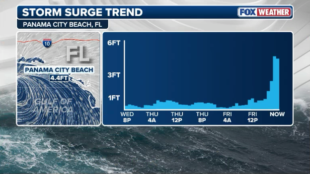
Latest storm surge data from Panama City Beach, Florida
With onshore winds continuing to peak near the eyewall, storm surge floodwaters are surging into coastal roads, parking areas, and low-lying beachfront properties.
A dangerous flooding situation is unfolding in Florida as Hurricane Isaias brings torrential rainfall to the Gulf Coast, prompting a Flash Flood Emergency.
A Flash Flood Emergency is the National Weather Service's most urgent flash flood warning designation, reserved for exceptionally dangerous, life-threatening flooding.
Residents in affected areas should avoid all unnecessary travel, stay away from flooded roads and seek higher ground if threatened by rising water.
Flooding can become life-threatening quickly, especially in low-lying communities and areas with poor drainage.
Intense hurricane conditions from Category 3 Hurricane Isaias lash the coast, with ferocious wind gusts and violent waves crashing along the coast in Fort Walton, Florida.
Storm surge water levels continue to rise steadily along the northern Gulf Coast as Hurricane Isaias pushes high water into bays and inlets.
A tide gauge at Panama City Beach is now reporting water levels 3.7 feet above normal tide, while Shell Beach has climbed to 3.5 feet.
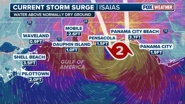
Life-threatening storm surge continues to ramp up along the coast
With onshore winds driving seawater inland ahead of the eyewall, coastal roads and low-lying areas are experiencing accelerating inundation.
Power outages are soaring across the region as Hurricane Isaias’ ferocious eyewall drives deep into the coastline.
More than 250,000 customers are now without electricity in Florida, while blackouts in Alabama have spiked to over 93,000.
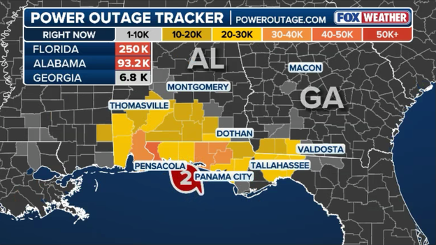
Latest power outage data from PowerOutage.com
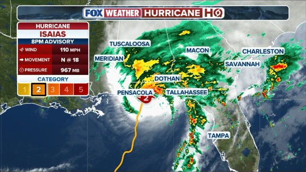
8 p.m. ET advisory from the National Hurricane Center
The 8 p.m. ET (7 p.m. CDT) advisory from the National Hurricane Center confirms Hurricane Isaias is on the verge of landfall in the Western Florida Panhandle.
Located just 45 miles southeast of Pensacola and 95 miles east-southeast of Mobile, Alabama, Isaias is packing maximum sustained winds of 110 mph with a minimum central pressure of 967 mb.
The storm continues moving north at 18 mph, spreading hurricane-force winds and extreme gusts across the entire warning area as the core roars ashore.
The National Hurricane Center has just released its official 8 p.m. ET (7 p.m. CT) advisory update, and meteorologists at the FOX Forecast Center are analyzing the new numbers as Hurricane Isaias makes its final push toward the shoreline.
We'll provide full analysis on the new track and updated landfall timing as we digest the latest advisory.
We are just moments away from the National Hurricane Center’s 8 p.m. ET full advisory update, which will provide the latest official pressure, wind speed, and precise track position as Hurricane Isaias makes its final push onto the Gulf Coast.
With hurricane-force winds and life-threatening storm surge actively pounding the shoreline, meteorologists at the FOX Forecast Center are standing by to break down the new advisory data as soon as it drops.
Stay locked right here for immediate analysis on landfall timing and updated track projections.
Hurricane force winds are hammering Destin, Florida, where FOX Weather Senior Field Correspondent Robert Ray is braving the blast fueled by the dangerous Category 3 Hurricane Isaias forecast to make landfall in just a few hours.
The dangerous eyewall of Hurricane Isaias is officially roaring ashore, bringing the storm's absolute worst conditions directly to the northern Gulf Coast.
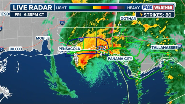
Radar image showing the eyewall of Hurricane Isaias roaring ashore
Landfall remains on track within the next two hours, but for communities along the shore, the core of the storm has already arrived.
Extreme hurricane-force winds, blinding torrential rain squalls, and life-threatening storm surge are currently peaking across coastal areas.
If you are anywhere in the path of the eyewall, stay locked in your safe interior shelter away from windows until the center moves through.
Dangerous winds are expanding rapidly inland across the Florida Panhandle and southern Alabama ahead of Hurricane Isaias’ official landfall.
counties. Everyone inland needs to stay sheltered in a sturdy building until conditions improve.
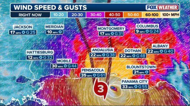
Latest wind speeds and wind gusts as Hurricane Isaias nears the coast
Tropical-storm-force wind gusts are already reaching well past coastal communities, snapping branches, downing trees, and taking out power lines miles from the beach.
Because Isaias is moving inland at a brisk pace, these high-energy gusts will push far beyond the shoreline tonight, bringing widespread structural damage and power outages deep into interior counties.
Violent eyewall winds are slamming the Pensacola area as Hurricane Isaias moves onshore.
A WeatherFlow station at Fair Point Light in Pensacola Bay recently recorded sustained hurricane-force winds of 76 mph alongside a ferocious gust of 96 mph.
Severe wind damage is occurring across Escambia and Santa Rosa counties, and all residents in the path of the eyewall should remain in interior safe rooms away from windows until the storm's core passes.
Conditions are rapidly deteriorating along the Emerald Coast, where a 75 mph wind gust was just recorded in Destin, Florida.
As Hurricane Isaias’ eyewall pushes onto the beaches, severe tropical squalls and hurricane-force gusts are slamming coastal communities.
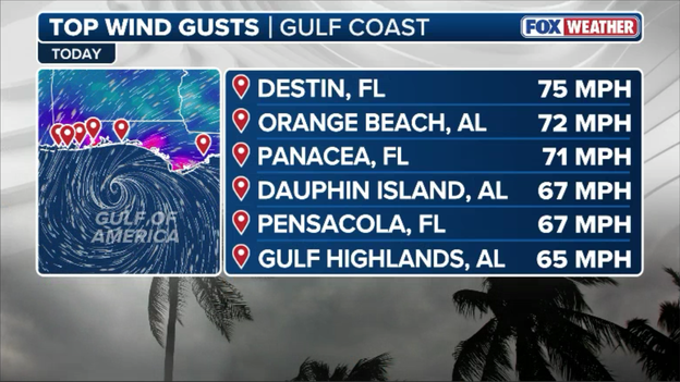
Top wind gusts recorded so far from Hurricane Isaias
Residents across Okaloosa County and the surrounding Panhandle should remain sheltered indoors away from windows, as these dangerous winds will continue to peak in intensity over the next few hours.
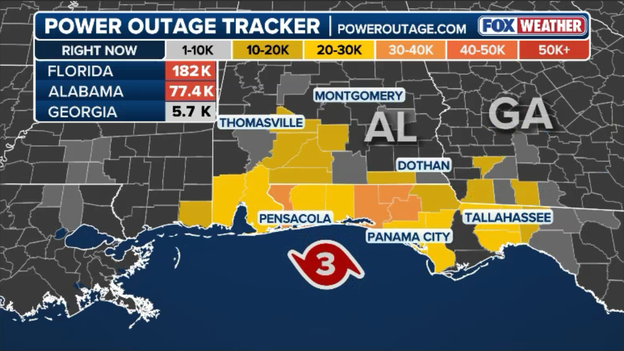
Latest power outage data from PowerOutage.com
Power outages are skyrocketing across the northern Gulf Coast as Hurricane Isaias’ violent eyewall slams ashore.
More than 182,000 customers are now without power in Florida, while over 77,000 homes and businesses are in the dark across Alabama as severe wind gusts snap power poles and knock out critical lines.
Dangerous storm surge continues to build along the Florida Panhandle and Big Bend coastlines as Hurricane Isaias pushes seawater ashore.
Tide gauges in both Panama City and Apalachicola are currently reporting water levels up to 2.5 feet above normal and climbing.
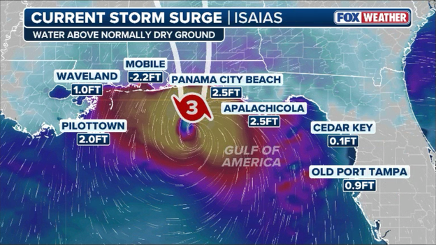
Data shows storm surge building along the Gulf Coast
Meanwhile, a starkly different scene is unfolding just to the west in Mobile Bay. Intense offshore winds howling out of the north are dragging water directly out of the bay—a phenomenon known as a "blowout tide"—leaving water levels down 2.2 feet below normal.
As the storm’s center passes north, those winds will shift abruptly, causing water to rapidly surge back into the bay.
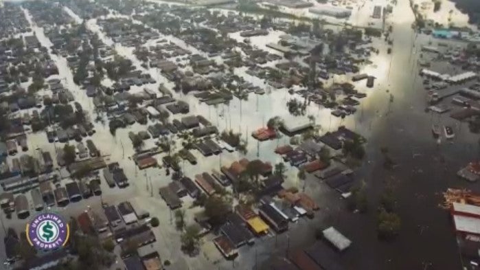
Hurricane Isaias is unleashing brutal conditions along Florida’s Gulf Coast, where FOX Weather Senior Correspondent Robert Ray is battling powerful winds and driving rain ahead of the Category 3 hurricane’s landfall.
As Hurricane Isaias nears landfall, Airbnb.org is partnering with local community organizations to provide free emergency housing for residents displaced by destructive winds and flooding.
Stays are fully funded through donor support and Airbnb.org, giving displaced families and staging first responders a safe, comfortable shelter.
When disaster strikes, a comfortable place to call home can make all the difference, while providing first responders an opportunity to recharge for the next day.
Florida residents under mandatory evacuations can check their eligibility by calling 211.
Local partners across the Gulf Coast will refer eligible residents to Airbnb.org for credits to book nearby homes close to their support networks, workplaces, or schools.
Airbnb.org says it is also working with All Hands & Hearts to provide free emergency housing for their first responders as they stage in the southeastern United States while preparing to deploy to support relief efforts.
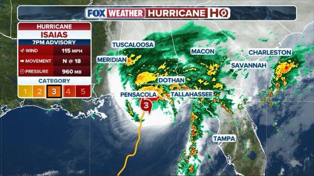
7 p.m. ET update from the National Hurricane Center
The eyewall of major Hurricane Isaias is nearing the northern Gulf Coast as of the National Hurricane Center’s 7 p.m. ET (6 p.m. CT) update.
Severe wind gusts are already lashing the region—including an 81 mph reading on an offshore Gulf buoy and a 75 mph gust near Perdido Bay—prompting an Extreme Wind Warning for parts of the western Florida Panhandle.
Holding maximum sustained winds of 115 mph, the center of the Category 3 storm sits just 55 miles south-southeast of Pensacola, Florida, and is moving north at 18 mph toward an imminent landfall.
Life-threatening storm surge is pushing onto the Gulf Coast as Hurricane Isaias approaches landfall, driving seawater into low-lying coastal neighborhoods.
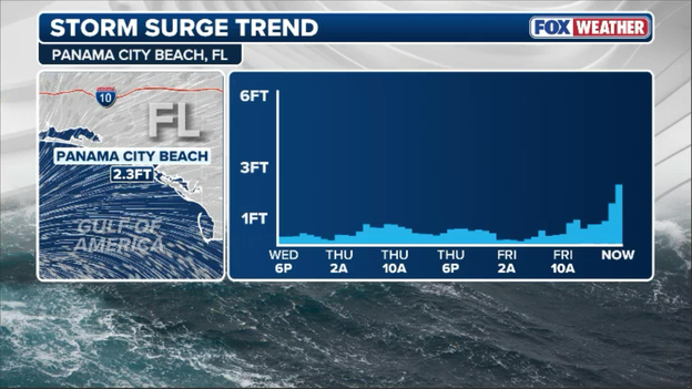
Tide gauge data showing the increase in water levels at Panama City, FL
In Panama City, water levels have already climbed to 2.3 feet above normal tide and continue to rise steadily as onshore winds pile Gulf waters against the coastline.
Residents in coastal inundation zones should stay far away from the shoreline and remain in safe, elevated shelter as storm-driven water continues to flood low-lying roads and bays.
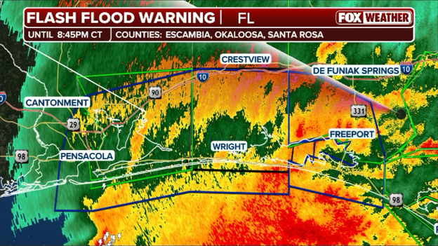
Extreme Wind Warning (in blue) issued for parts of the Florida Panhandle
An Extreme Wind Warning has just been issued for portions of the Florida Panhandle as Hurricane Isaias’ violent eyewall roars ashore.
Reserved only for the most life-threatening tropical conditions, an Extreme Wind Warning means major hurricane-force winds of 115 mph or greater are imminent or already occurring.
The warning includes Pensacola, Fort Walton Beach to Rosemary Beach.
Emergency officials advise residents in the warned area to treat this alert just like a Tornado Warning—move immediately to an interior, windowless room on the lowest floor of a sturdy building and take cover until the core passes.
Power outages in Florida have topped 100,000 customers as Hurricane Isaias’ outer bands and powerful wind gusts hammer the Sunshine State.
The bulk of the blackouts are concentrated in Holmes, Leon, and Walton counties, where intense squalls have snapped trees and brought down power lines.
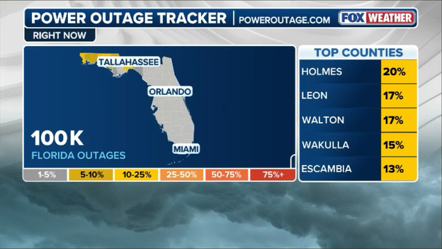
Latest power outage data from PowerOutage.com
With the storm's eyewall continuing to push closer to the coastline, utility crews must wait until dangerous tropical-storm-force winds subside before they can safely deploy bucket trucks to begin restoring electricity.
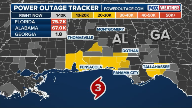
Latest power outage numbers from PowerOutage.com
Power outages are surging across the northern Gulf Coast as Hurricane Isaias’ violent wind gusts and heavy squalls snap tree limbs and knock out utility lines.
Data from PowerOutage.com shows over 75,000 customers in Florida and another 67,000 customers in Alabama are currently in the dark as the storm's vicious rainbands roar ashore.
Utility crews remain on standby, but line workers won't be able to safely bucket up and begin repairs until the extreme winds drop below hazardous thresholds.
FOX News Multimedia Reporter Chelsea Torres is live in Pascagoula, Mississippi, tracking deteriorating conditions on the ground as Hurricane Isaias approaches landfall.
As Hurricane Isaias’ powerful winds batter the Gulf Coast, an Alabama utility provider has suspended power restoration efforts as trees topple onto power lines.
Baldwin EMC reported significant tree damage and impacts to its power system as Hurricane Isaias moves toward the Alabama coast.
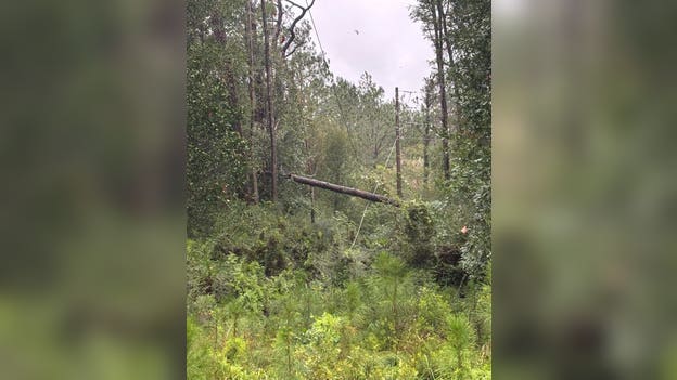
Utility crews across the Gulf Coast are facing treacherous conditions as Hurricane Isaias approaches. Credit: Baldwin EMC
Baldwin County, along Alabama’s Gulf Coast, is among the first areas feeling Hurricane Isaias’ impacts.
More than 65,000 customers across Alabama were already without power, according to PowerOutage.com.
We have reached the point where, due to increasing wind speeds and the safety of our crews, we must pull them in for the evening.
The utility provider said crews will return at daybreak to assess the damage and begin cutting trees, clearing lines, replacing damaged infrastructure and restoring power as safely and quickly as possible.
Baldwin EMC’s struggle is just one snapshot of what utility crews across the Gulf Coast are facing as Hurricane Isaias unleashes dangerous winds, topples trees and knocks out power along its path.
Chevron says it is deploying severe-weather response protocols across its Gulf Coast operations to safeguard personnel, protect coastal facilities, and maintain critical fuel supplies as Hurricane Isaias approaches.
Offshore, the energy giant has evacuated most platform workers, using remote technology to safely maintain production at four deepwater sites while shutting in operations at five others.
We understand fuel supply is critical and are working to safely minimize disruptions from the storm.
Onshore supply teams are actively monitoring regional fuel inventories and tracking demand shifts to ensure gas supplies remain stable throughout the storm and recovery efforts.
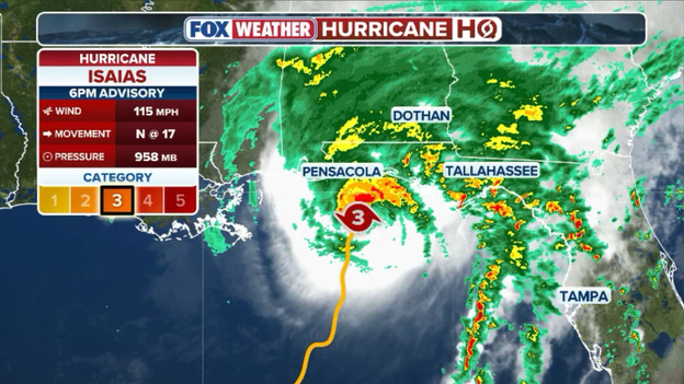
6 p.m. ET update from the National Hurricane Center
The National Hurricane Center's 6 p.m. ET (5 p.m. CT) position update shows Hurricane Isaias holding strong at 115 mph as its eyewall creeps within 60 miles south-southeast of Pensacola, Florida, and 95 miles southeast of Mobile, Alabama.
Near-hurricane wind gusts are already slamming coastal communities, with Orange Beach, Alabama, registering a 75 mph gust and an offshore NOAA buoy logging 69 mph winds as the major storm pushes north at 17 mph.
As Hurricane Isaias bears down on the Gulf Coast, Alabama Governor Kay Ivey is urging residents statewide to stay vigilant against widespread threats of damaging winds, heavy rain, and spinoff tornadoes.
The state has fully staged emergency resources alongside key private partners, including free Uber rides (code ISAIAS26) to approved shelters in Mobile and Baldwin counties, opened Comcast Wi-Fi hotspots, and an activated Home Depot emergency response center.
As we have watched this storm’s track, it has only gained in strength, so I am urging Alabamians to please remain vigilant.
Residents can text "Alalert" to 77295 for updates or call 2-1-1 for local assistance as storm impacts push inland.
FOX Weather Meteorologist Haley Meier is on the move along the Gulf Coast, tracking Hurricane Isaias in real time from inside the custom-built FOX Weather Beast.
Armed with weather sensors and live broadcast technology, Meier is driving directly through incoming rainbands to deliver live updates on wind speeds and road conditions as the dangerous storm closes in.
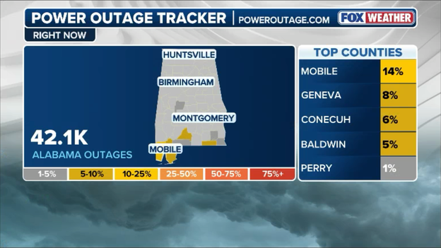
Latest power outage numbers from PowerOutage.com
Power outages are shooting up rapidly across southern Alabama as damaging wind gusts and heavy squalls roll inland ahead of Hurricane Isaias.
According to PowerOutage.com, more than 48,000 homes and businesses have lost electricity state-wide, with Mobile and Geneva counties taking the hardest hit so far.
As conditions continue to deteriorate through the evening, repair crews will have to wait out the worst of the storm before safely heading out to restore power.
We are officially down to the wire with Hurricane Isaias targeting landfall around 9 p.m. ET, and you can really see weather conditions taking a turn for the worse across the Gulf Coast.
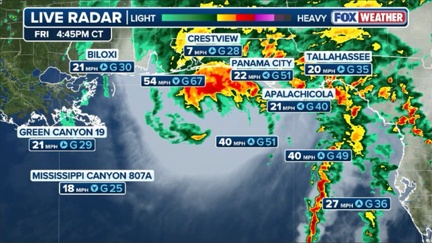
Radar showing Hurricane Isaias nearing the coast with powerful winds ramping up
Tropical-storm-force winds are already whipping far inland, bringing blinding rain squalls and a growing flash flood threat across the Florida Panhandle and southern Alabama.
Along the beaches, water levels are rapidly rising as the storm surge builds, and severe wind gusts are starting to hit as the core closes in.
If you are anywhere in the path of this storm, time has run out to be outside—get into your safe shelter now and plan to stay put as the worst of Isaias rolls through tonight.
FOX Weather Senior Correspondent Robert Ray gives a behind-the-scenes look at his reporting setup in Destin, Florida, as he readies his equipment for Hurricane Isaias’ landfall.
The core of Hurricane Isaias—packing the storm’s strongest, most destructive winds and torrential rain bands—is now sitting just offshore and pushing toward the coastline.
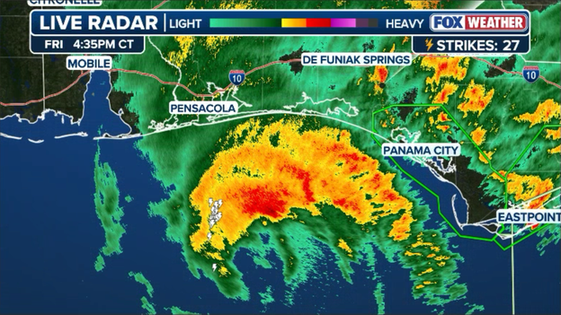
Doppler radar shows an area of intense rain associated with the center of Isaias just offshore
Everyone in the path of the eyewall should be sheltered in place as conditions are expected to reach peak severity within the hour.
FOX Weather Hurricane Specialist Bryan Norcross broke down the National Hurricane Center’s crucial 5 p.m. ET advisory, detailing what to expect in these final hours before Hurricane Isaias moves onshore.
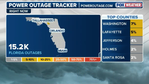
Latest power outages across Florida from PowerOutage.com
Power outages are steadily climbing across the Florida Panhandle as tropical-storm-force winds and rainbands knock down tree limbs and utility lines.
According to PowerOutage.com, more than 15,000 customers are currently without electricity across the state, with the heaviest concentration of outages reported in Washington, Lafayette, and Jefferson counties.
Utility crews are staged and ready to respond, but power restoration efforts will hold in areas where high winds make operating bucket trucks unsafe.
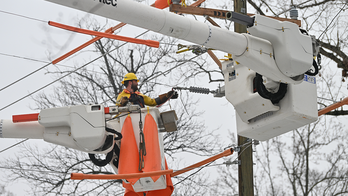
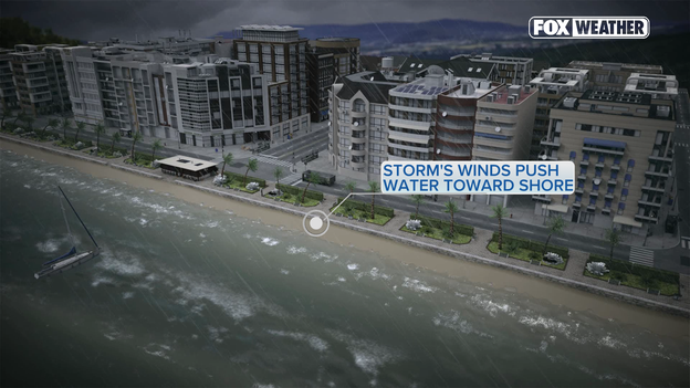
Storm's winds push water toward shore
Storm surge is an abnormal, rapid rise of water generated by a hurricane's strong winds pushing ocean water toward the shore, completely overwhelming natural sea levels.
Unlike normal waves that crash and recede, a surge acts like a massive, continuous wall of water that moves rapidly inland, flooding coastal terrain within a matter of minutes.
Historically, storm surge is the single deadliest threat associated with tropical cyclones, causing the majority of hurricane-related fatalities due to the sheer velocity, weight, and sudden height of incoming floodwaters.
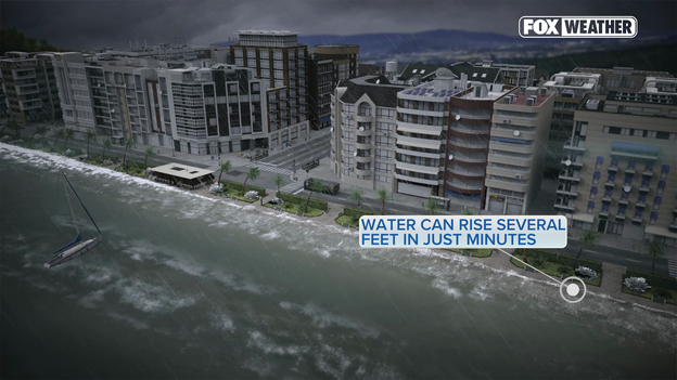
Water can rise several feet in just minutes
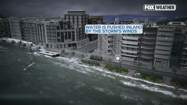
Water is pushed inland by the storm's winds
For Hurricane Isaias, forecasters warn that a peak storm surge of 6 to 9 feet above ground level is expected along the stretch from the Alabama/Florida border to Grayton Beach, FL.
Just a few feet of water can easily wash away coastal roads, flood lower levels of homes, and trap residents who fail to evacuate in time.
With water levels expected to rise rapidly as the storm moves closer, anyone in vulnerable low-lying areas should take mandatory evacuation orders seriously before access routes are completely submerged.
Intense storm conditions continue to build along the Destin, Florida coastline this evening, bringing powerful wind gusts, heavy surf, and steady rain.
Video from the shore shows rough, rocking waves battering the harbor as a lone boater navigates the churning waters while Hurricane Isaias approaches landfall.
As Hurricane Isaias makes its final approach, strong high-altitude winds—known as deep-layer wind shear—are tearing into the storm's upper levels and tilting its internal structure.
Doppler radar shows the hurricane becoming noticeably lopsided, with the vast majority of intense thunderstorms and heaviest rain getting shoved directly into the northern half of the eyewall.
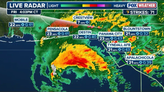
Doppler radar shows a lopsided hurricane with the heaviest rain and strongest winds north and east of the eye
While this atmospheric push keeps the storm asymmetrical rather than perfectly round, reconnaissance aircraft flying high inside the storm are still recording brutal wind speeds above 140 mph at 10,000 feet up.
However, instrument sensors dropped into the eyewall reveal that these extreme high-altitude winds are struggling to fully make it down to the ocean's surface.
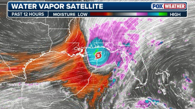
Satellite data reveals strong wind shear now tearing into the western side of Hurricane Isaias
The National Hurricane Center says sustained surface winds are holding closer to 115 mph (100 knots).
Even with that slight drop in sustained surface power, residents along the coast should prepare for a particularly dangerous arrival: Isaias will likely deliver sharp, violent wind gusts well above its sustained strength as the heavy northern eyewall slams onshore.
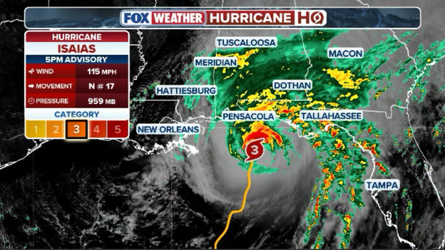
5 p.m. ET advisory from the National Hurricane Center
The National Hurricane Center’s 5 p.m. ET (4 p.m. CDT) advisory warns that conditions are deteriorating rapidly across all storm surge and hurricane warning areas as major Hurricane Isaias approaches land.
Currently located just 90 miles south of Pensacola, Florida, and 125 miles south-southeast of Mobile, Alabama, Isaias is packing 115 mph maximum sustained winds and moving north at 17 mph with a central pressure of 959 mb.
With time officially out to make outdoor preparations, officials stress that all residents in the path of the storm should be seeking safe shelter immediately as life-threatening surge and hurricane-force winds push onshore.
The National Hurricane Center has released its full 5 p.m. ET (4 p.m. CDT) advisory. Our team of experts is analyzing it now and we'll provide a full breakdown for you in the minutes ahead.
The tornado threat is ramping up across Florida as powerful Hurricane Isaias approaches the Gulf coast, with the National Weather Service issuing tornado warnings for parts of the Panhandle and Big Bend region.
A Tornado Warning was issued earlier Friday afternoon for portions of Gulf and Franklin counties after radar detected rotation in a thunderstorm near St. George Island.
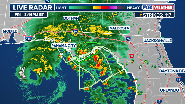
Rain bands pushing into Florida.
The storm was moving northwest at about 40 mph, threatening communities including Apalachicola and Eastpoint.
A broader Tornado Watch remains in effect until 9 p.m. EDT for portions of the Florida Panhandle and Big Bend.
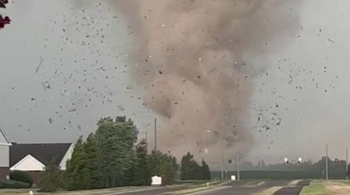
The Storm Prediction Center warns that Isaias' outer rain bands could produce more tornadoes through the evening and overnight hours, with the threat extending into southeastern Alabama and southwestern Georgia.
Residents are urged to remain alert for new warnings and seek shelter immediately if a tornado warning is issued for their location.
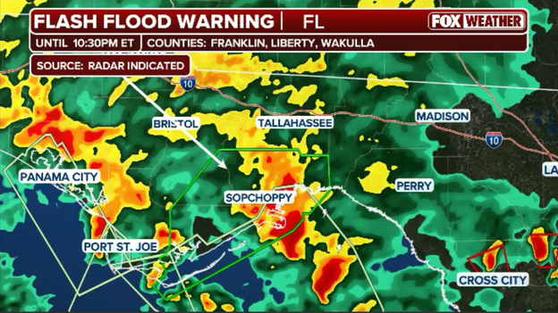
Radar showing heavy rain rolling into Tallahassee, Florida
Torrential rainbands from Hurricane Isaias are pushing into the Tallahassee area, prompting a Flash Flood Warning along the coast.
Drivers across Leon and surrounding coastal counties should avoid travel as low-lying spots inundate, and residents are urged to remember to never drive through flooded roads.
With landfall just hours away, we are standing by for the National Hurricane Center’s full 5 p.m. ET (4 p.m. CT) advisory.
Following recent reconnaissance flights that detected drops in central barometric pressure, this upcoming update will provide essential clarity on whether Category 3 Hurricane Isaias has undergo any fluctuations in wind speed or structure. Beyond potential intensity tweaks, the 5 p.m. advisory will deliver an updated forecast track.
The FOX Forecast Center is preparing to analyze the new advisory numbers immediately upon release. Stay tuned for a full breakdown.
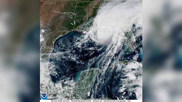
Hurricane Isaias nears landfall along the Gulf coast.
Hurricane Isaias is closing in on the Florida Panhandle, with landfall estimated between 9 and 10 p.m. ET Friday somewhere between Pensacola and Fort Walton Beach.
The FOX Forecast Center said the storm's center is less than 90 miles offshore and moving north at 17 mph, putting the region just hours away from landfall.
Conditions are expected to deteriorate rapidly between 6 and 7 p.m. ET as the hurricane's eyewall, containing its most dangerous winds, approaches the coast from about 40 miles offshore.
Residents along the Florida Panhandle should remain sheltered as the hurricane's most dangerous conditions move ashore.
As dangerous Hurricane Isaias closes in on Florida's Gulf Coast, FOX Weather Exclusive Storm Tracker Brandon Copic stopped to help a man whose vehicle was stuck in the sand at Navarre Beach.
Copic shared video of the encounter, showing the effort to free the man from the sand as conditions worsened ahead of the hurricane's arrival.
"We were able to get this gentleman out of the sand in Navarre Beach as Hurricane Isaias approaches the Florida Coast," Copic wrote on Facebook.
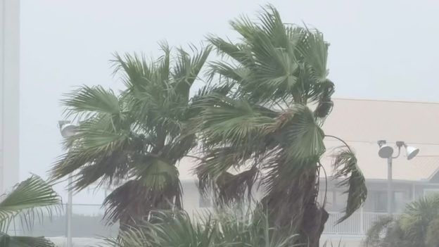
Palm trees sway in the breeze as Hurricane Isaias approaches on Friday, Oct. 9, 2026.
Conditions are rapidly deteriorating along the northern Gulf Coast as powerful Category 3 Hurricane Isaias barrels toward landfall with maximum sustained winds of 120 mph.
According to the National Hurricane Center's latest update, Isaias was located about 90 miles south of Pensacola, Florida, and 115 miles south-southeast of Mobile, Alabama, moving north at 17 mph.
The storm's powerful winds are already being felt along the coast, with a 56 mph wind gust recorded at NOAA buoy 42012 and a 47 mph gust reported at Navarre Beach, Florida.
Florida Governor Ron DeSantis talks about what residents should expect ahead of Hurricane Isaias, which is anticipated to have significant impacts such as widespread power outages as the Category 3 storm hammers the Sunshine State.
President Donald Trump announced he will no longer attend the highly anticipated Alabama-Georgia football game as Hurricane Isaias approaches the Gulf Coast, citing concerns about diverting emergency resources away from storm response efforts.
In a post on Truth Social, Trump said he wanted first responders, law enforcement and other emergency personnel focused entirely on the approaching hurricane rather than his security and presence at the game.
Trump expressed hope that the game would still take place despite the weather and said he plans to visit both teams at a later date.
Instead, Trump said he would travel to Tennessee for a hastily organized political rally supporting congressional candidates, Sen. Bill Hagerty and Marsha Blackburn.
Several major bridges in the Pensacola, Florida, area have been closed as weather conditions deteriorate ahead of Hurricane Isaias' landfall along the Gulf Coast.
Pensacola police closed the Pensacola Bay Bridge to traffic, while the Escambia County Sheriff's Office also shut down the Theo Baars and Bob Sikes bridges, according to local officials.
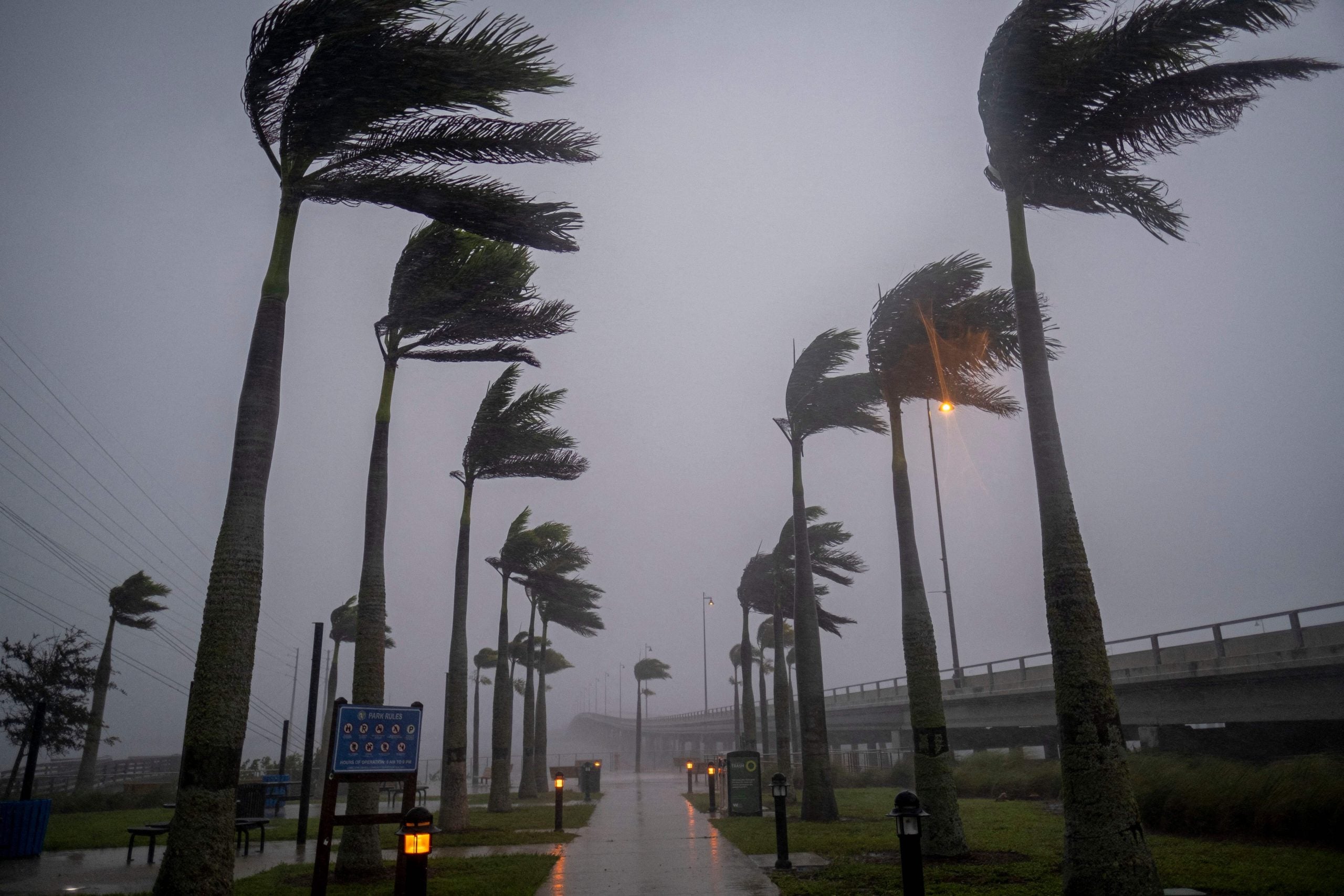
The closures come as worsening conditions from the approaching hurricane make travel increasingly dangerous across the region.
Access to several popular Alabama beach communities has been restricted as Hurricane Isaias approaches the Gulf Coast.
The Alabama Emergency Management Agency announced that the Alabama Highway 59 and Highway 161 bridges over the Intracoastal Waterway are closed, restricting access to Gulf Shores, Orange Beach and Fort Morgan to emergency services only.
Officials urged residents to monitor the Alabama Department of Transportation and local emergency management agencies for the latest road conditions and updates.
Watch live as Florida Governor Ron DeSantis provides an update on state preparations ahead of Isaias' expected landfall this evening.
Check out this behind-the-scenes look inside FOX Weather’s Studio W as meteorologist Bob Van Dillen tracks Hurricane Isaias.
Both NOAA and U.S. Air Force Reserve Hurricane Hunter aircraft currently flying inside Hurricane Isaias are reporting drops in the storm's minimum central pressure.
Falling barometric pressure inside the eye is a clear signal of ongoing atmospheric organization and potential intensification in the final hours before landfall.
Our team is closely monitoring the raw flight-level wind data and dropsonde soundings transmitting live from the aircraft.
We are standing by for the National Hurricane Center to review these recon passes and determine if any official adjustments will be made to Isaias' maximum sustained winds or central pressure.
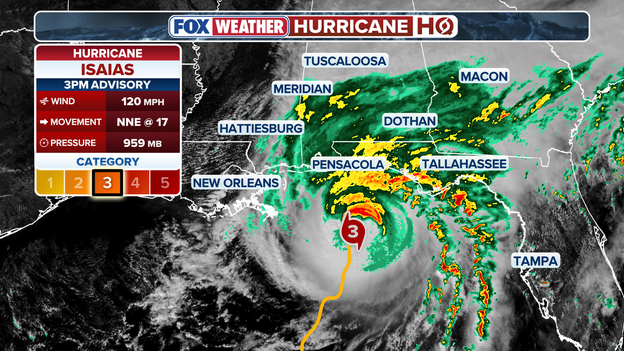
Latest 3 p.m. ET update from the National Hurricane Center
The National Hurricane Center has released its 3 p.m. ET (2 p.m. CT) intermediate position update, confirming that tropical storm conditions are now officially spreading onshore along the northern Gulf Coast.
Recent coastal observations show the storm's expanding wind field in action, with a gust of 43 mph reported in Apalachicola, Florida.
Major Hurricane Isaias is currently located about 125 miles south of Pensacola, Florida, and 140 miles south of Mobile, Alabama, moving north-northeast at 17 mph.
The Category 3 storm continues to maintain peak sustained winds of 120 mph with an intense central pressure of 959 mb, measured by NOAA Hurricane Hunter aircraft.
With conditions worsening rapidly along the shore, all final preparations should be completed immediately as the outer core of the storm moves inland.
Wind speeds are ramping up swiftly along the northern Gulf Coast as the expanding wind field of major Hurricane Isaias approaches the shoreline.
Coastal weather stations from Dauphin Island and Gulf Shores in Alabama to Pensacola, Destin, and Panama City in Florida are already reporting sustained tropical-storm-force winds with frequent gusts topping 45 mph.
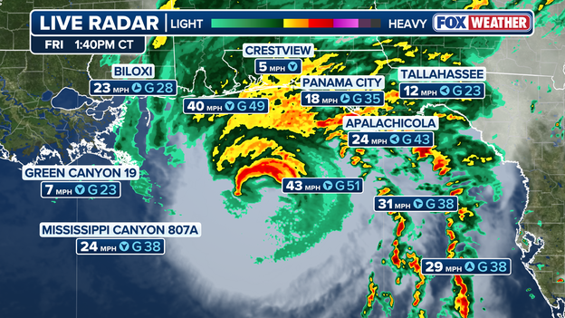
Wind speeds continue to ramp up as Hurricane Isaias closes in on the coast
Reporting live from Destin, Florida, FOX Weather Senior Correspondent Robert Ray is tracking a sharp turn for the worse as outer rainbands from major Hurricane Isaias sweep across the Emerald Coast.
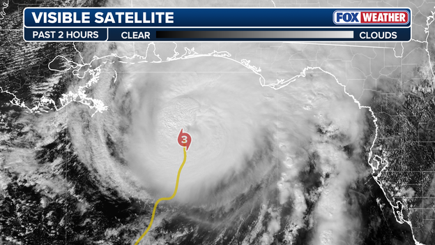
GOES-East satellite tracking Isaias' movement from space
As major Hurricane Isaias makes its final approach toward the northern Gulf Coast, FOX Weather meteorologists are closely monitoring real-time observational data for subtle shifts that can significantly alter local impacts.
In these crucial final hours before the eye reaches the shoreline, two key factors remain under intense focus:
Short-Term Track "Wiggles"
Hurricanes rarely move in a perfectly straight line; the eye often wobbles or oscillates around its broader steering track. Forecasters are watching closely to see if Isaias jogs slightly left or right of its projected north-northeastward path.
Even a minor shift of 10 to 20 miles can alter which coastal communities experience the destructive right-front quadrant—where peak storm surge, highest winds, and embedded tornadoes are concentrated.
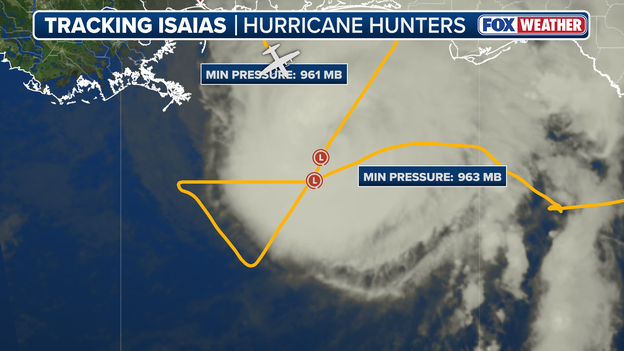
Hurricane Hunters are flying through Isaias to track its every move and any intensity changes up until landfall
Intensity Fluctuations via Hurricane Hunters
Data streaming continuously from NOAA and Air Force Reserve Hurricane Hunter aircraft punching through the eyewall provides immediate ground-truth measurements of the storm's health.
Reconnaissance passes measure central pressure trends, surface wind speeds via Stepped Frequency Microwave Radiometers (SFMR), and internal eyewall structure. We are watching for signs of eyewall replacement cycles or short-term intensity changes right up until landfall.
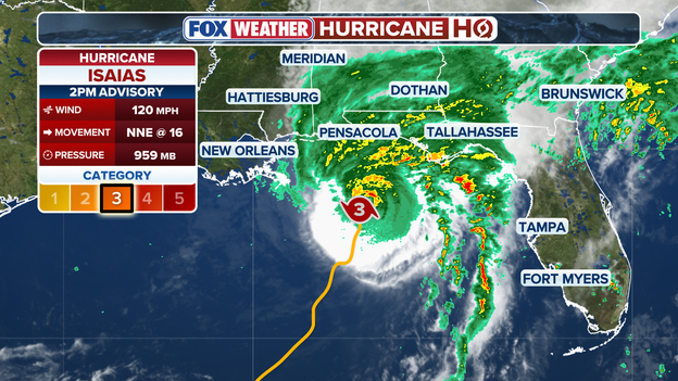
2 p.m. ET advisory from the National Hurricane Center
The National Hurricane Center has issued its 2 p.m. ET (1 p.m. CDT) advisory, warning that tropical-storm-force winds are officially pushing onshore along the northern Gulf Coast.
Located about 145 miles south of Pensacola, Florida, and 125 miles east-southeast of the mouth of the Mississippi River, major Hurricane Isaias continues to hold maximum sustained winds of 120 mph with a minimum central pressure of 959 mb.
The Category 3 storm is moving north-northeast at 16 mph.
The National Hurricane Center has issued its full 2 p.m. ET (1 p.m. CT) advisory for Hurricane Isaias.
Our team is actively reviewing the latest coordinates, minimum central pressure readings, and updated wind speed data from the bulletin as the major storm continues its fast approach toward the northern Gulf Coast.
We will have a complete breakdown of the revised forecast track, storm surge inundation levels, and inland warning updates posted here shortly.
Meteorologists and emergency officials across the northern Gulf Coast are standing by for the National Hurricane Center’s 2 p.m. ET (1 p.m. CT) advisory.
Following the intermediate update at 1 p.m. that placed Category 3 Hurricane Isaias just 160 miles south of Pensacola with 120 mph winds, this upcoming complete update will provide a newly refreshed forecast track, updated wind speed probabilities, and refined storm surge inundation models ahead of tonight’s anticipated landfall.
Stay tuned as we break down the latest coordinates, intensity metrics, and warnings as soon as the NHC transmits the bulletin.
Tide gauges along the northern Gulf Coast are recording a steady rise in water levels as major Hurricane Isaias continues to push seawater onshore ahead of its evening landfall.
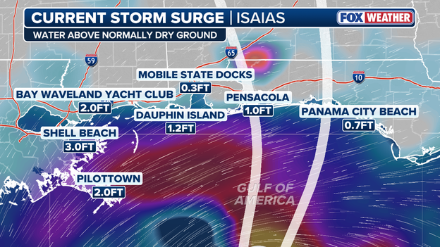
Latest storm surge data showing rising water levels along the Gulf Coast
The latest real-time coastal observations show that Pilottown, Louisiana, has reached 2.0 feet above normal tide levels, while Dauphin Island, Alabama, is reporting 1.2 feet of surge and Pensacola, Florida, has risen to 1.0 foot.
These water level increases mark the leading edge of the storm's powerful ocean surge.
As onshore winds strengthen and align directly with the coast throughout the afternoon, inundation will increase rapidly along low-lying coastal roads, bays, and sounds across the region.
The FOX Forecast Center projects that Hurricane Isaias will make landfall along the northern Gulf Coast around 10 p.m. ET (9 p.m. CT) tonight.
While heavy rainbands, destructive winds, and storm surge are already pushing onshore, meteorologists measure the exact moment of landfall by a very precise technical definition.
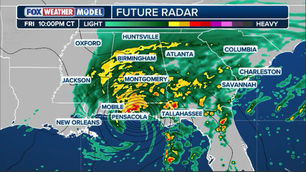
Exclusive FOX Weather Model showing landfall near the Florida Panhandle around 10 p.m. ET.
According to the National Hurricane Center (NHC), landfall officially occurs when the surface center of the hurricane's eye crosses the coastline.
Because a tropical cyclone's strongest winds and highest storm surge sit within the eyewall surrounding the center—and often extend outward for dozens of miles—the most dangerous hazards routinely arrive hours before official landfall occurs.
Coastal residents should not wait for the eye to reach the shoreline to seek shelter, as severe conditions are already rapidly deteriorating across the region.
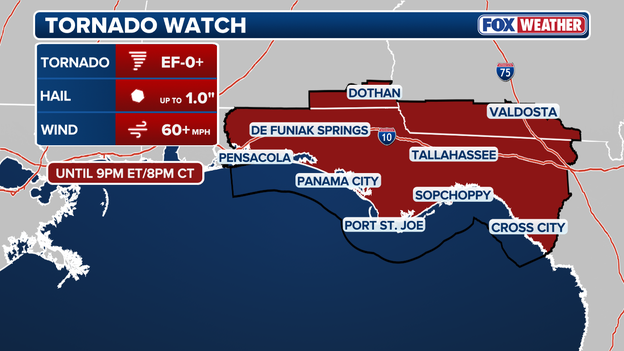
The Storm Prediction Center has issued a Tornado Watch ahead of Isaias until 9 p.m. ET.
The Storm Prediction Center has issued a Tornado Watch effective until 9:00 p.m. ET (8:00 p.m. CT) for the Florida Panhandle, extreme southern Georgia, and southeast Alabama.
As the strong outer rainbands of Hurricane Isaias sweep onshore, strong low-level wind shear created by the storm's circulation increases the risk for quick-hitting, embedded tornadoes.
Tropical tornadoes often form rapidly within squalls with little advance warning.
Residents across northern Florida, southern Alabama, and southwest Georgia should keep multiple weather alert methods active, review their safe room plans, and be prepared to take immediate cover if a Tornado Warning is issued for their area.
Florida Governor Ron DeSantis joined FOX Weather meteorologist Bob Van Dillen live to discuss the state’s final preparations as major Hurricane Isaias approaches the Panhandle.
DeSantis emphasized that emergency response teams, search-and-rescue assets, power restoration crews, and state supplies are fully staged and positioned across vulnerable northern counties.
Reassuring residents in the storm's immediate path, DeSantis told Van Dillen that Florida is "ready to go" for the evening's anticipated landfall.
The City of Mobile, Alabama, has announced a mandatory general curfew set to take effect tonight, October 9, from 7:00 p.m. through 6:00 a.m. tomorrow morning, October 10, as Hurricane Isaias makes its final approach.
City officials are directing all residents to remain sheltered safely indoors throughout the night. Keeping roads clear during the peak of the storm ensures that emergency first responders and municipal assessment crews can safely navigate the city and respond to critical situations as soon as daylight breaks.
With the main threats forecasted to be significant storm surge along Mobile Bay, flash flooding, and damaging winds, residents should finalize all outdoor preparations and stay off the streets well before the 7:00 p.m. deadline.
Video from Pensacola Beach shows heavy surf beginning to churn near the Gulf pier as Hurricane Isaias maintains its push toward the northern Gulf Coast.
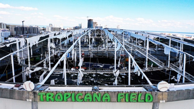
Paul Hennessy/SOPA Images/LightRocket via Getty Images
Today marks exactly two years since Hurricane Milton slammed into Florida's west coast near Siesta Key as a powerful Category 3 storm on October 9, 2024.
Milton brought extreme winds exceeding 120 mph, catastrophic storm surge, and a historic multi-county tornado outbreak—standing as the last hurricane to make landfall on the United States mainland.
Hurricane Milton was retired by the World Meteorological Organization after slamming Florida in 2024
The two-year gap without a U.S. landfalling hurricane ends today as Hurricane Isaias approaches the northern Gulf Coast.
As residents put the finishing touches on their storm preparations, the anniversary serves as a stark reminder of how rapidly tropical systems can intensify in late autumn and the crucial importance of heeding local evacuation and safety orders.
Mobile Mayor Spiro Cheriogotis joined FOX Weather live to break down how the city is responding ahead of the incoming surge and tropical-storm-force winds.
Mayor Cheriogotis highlighted active preparations across Mobile County, including flood-prone area evacuations, drainage clearing, and the staging of emergency crews.
Panama City Beach remains deceivingly calm for now, but conditions are expected to deteriorate rapidly throughout the afternoon as major Hurricane Isaias approaches the Florida Panhandle.
FOX News Senior Correspondent Jonathan Serrie breaks down the timeline of incoming hazards as the storm's outer circulation pushes onshore.
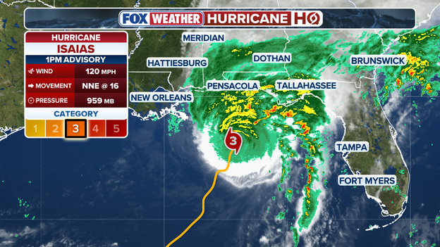
1 p.m. ET update from the National Hurricane Center
The National Hurricane Center released its 1 p.m. ET intermediate position update, reiterating that life-threatening storm surge and devastating winds are imminent along the Florida Panhandle and Alabama coastlines.
Latest reconnaissance data gathered by a NOAA Hurricane Hunter aircraft confirms the system's central pressure holds steady at an intense 959 mb (28.32 inches).
The major Category 3 storm continues to maintain maximum sustained winds of 120 mph while accelerating north-northeastward at 16 mph.
Positioned approximately 160 miles south of Pensacola, Florida, and 130 miles southeast of the mouth of the Mississippi River, Isaias is steadily closing the gap toward a expected landfall tonight, making immediate shelter completion vital across the northern Gulf Coast.
In a statement shared on social media, the Tampa Bay Rays reflected on the recovery journey and paid tribute to the area's ongoing strength and unity.
The Rays organization and its foundation have remained closely involved in local relief and rebuilding efforts alongside first responders and community partners across the Bay Area.
Hurricane Isaias is disrupting air travel nationwide as high-altitude winds and severe weather force air traffic controllers to close key flight corridors across the northern Gulf of America.
According to FlightAware, over 3,000 flights have been delayed and more than 320 canceled across the United States today as major carriers reroute commercial traffic around the expansive outer circulation of the Category 3 storm.
- Standard offshore routing tracks across the northern Gulf are effectively cutoff, forcing coast-to-coast and north-south flights into congested inland air corridors.
- As Isaias tracks inland and accelerates northeastward through the weekend, ground stops and delay programs are expected to ripple toward Mid-Atlantic and East Coast airports.
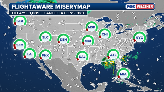
FlightAware MiseryMap showing nationwide disruptions this afternoon
Major airlines—including Delta, American, United, and Southwest—have issued severe weather travel waivers allowing passengers traveling through affected Gulf Coast terminals to rebook without change fees. Passengers are strongly advised to check flight statuses directly with their carriers before heading to the airport.
As Hurricane Isaias approaches the Florida Panhandle and Big Bend as a major storm, Attorney General James Uthmeier has activated Florida's Price Gouging Hotline to protect residents from illegal price spikes on essential goods.
Under Section 501.160 of Florida Statutes, it is unlawful during a declared state of emergency to charge unconscionable prices for commodities and services vital for preparation or recovery—including water, food, ice, gasoline, lumber, generators, and hotel rooms.
Protecting Floridians isn't a seasonal job, and this hotline ensures that there is a simple process to report unconscionable increases in prices.
The activation applies across the 27 counties listed under Governor DeSantis's state of emergency order, including Escambia, Santa Rosa, Okaloosa, Walton, Bay, Gulf, Franklin, Wakulla, Leon, and surrounding inland areas.
And wiolators face civil fines of up to $1,000 per individual violation, capping at $25,000 for multiple infractions within a single 24-hour period, alongside potential criminal prosecution.
Real-time offshore observations show that tropical-storm-force winds have officially arrived just off the coastline.
Buoy 42012, located 12 miles south of Orange Beach, Alabama, is now reporting sustained winds of 42 mph with peak gusts reaching 52 mph.
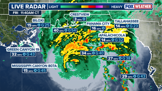
Hurricane Isaias is closing in on the Gulf Coast with torrential rain and destructive winds
As the storm continues its north-northeastward march, sustained tropical-storm-force winds are projected to reach the immediate coast by 2:00 p.m. ET.
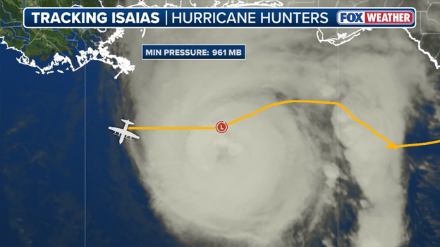
Hurricane Hunters data shows Isaias maintaining its strength this afternoon
Fresh recon data from the Hurricane Hunters flying directly through the core of Hurricane Isaias shows the storm is holding firmly onto its major Category 3 intensity.
Flight-level wind readings and dropsonde drops continue to confirm max sustained winds near 120 mph and a deeply organized inner eyewall.
Despite interacting with increasing atmospheric wind shear, the hurricane's robust core is refusing to weaken as it advances north-northeastward toward the coast—ensuring that peak major hurricane force will be delivered directly to the shoreline at landfall.
NOAA’s WP-3D Orion aircraft (N43RF), affectionately known as "Miss Piggy," has just punched through the dangerous eastern eyewall of Hurricane Isaias.
Direct flight-level observations and dropsonde data from inside the core confirm that the hurricane remains intensely organized as it approaches the coast.
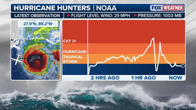
Latest reconnaissance data from the Hurricane Hunters flying through Isaias
These reconnaissance penetrations provide critical ground-truth measurements of peak flight-level winds and central pressure that satellite imagery alone cannot detect.
The data collected during this run is being beamed directly to National Hurricane Center forecasters in real time to refine final intensity trends and coastal surge forecasts ahead of landfall.
Florida Governor Ron DeSantis says all state resources are ready to respond and support impacted communities as Isaias targets the Panhandle.
To ensure every resident in the storm's path can reach a safe location, the State of Florida has partnered with Uber to offer free rides to official evacuation shelters ahead of Hurricane Isaias.
If you or someone you know needs transportation to escape high-risk or surge zones, you can claim a free round-trip ride directly through the app.
Heavy rainbands from Hurricane Isaias are now officially sweeping across the Gulf Coast, bringing intense downpours, severe visibility drops, and rapidly building wind squalls.
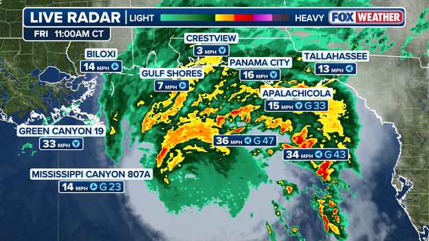
Isaias' outer bands of heavy rain and strong winds are spreading dangerous conditions along the Gulf Coast
Marine observation stations off the Southwest Pass of the Mississippi River have already clocked wind gusts reaching 60 mph, confirming that tropical-storm to gale-force conditions are taking hold along the outer periphery of the storm.
Winds will only continue to escalate through the rest of the afternoon as Isaias pushes closer to landfall.
Highlighting the extreme environment near the storm's core, an uncrewed NOAA Saildrone (SD-1045) operating near the eyewall recently clocked a maximum wind gust of 104 mph.
The National Hurricane Center has issued an intermediate position update as of 12 p.m. ET, issuing a stark warning that life-threatening storm surge and devastating winds are likely across the Florida Panhandle and Alabama coastlines.
Isaias is currently located about 180 miles south of Pensacola, Florida and moving NNE at 16 mph.
While the immediate focus remains on landfall along the Gulf Coast, Hurricane Isaias will not stop at the shore.
As the storm tracks inland and accelerates northeastward over the weekend, its expansive moisture footprint will spread tropical hazards across a broad swath of the Eastern Seaboard.
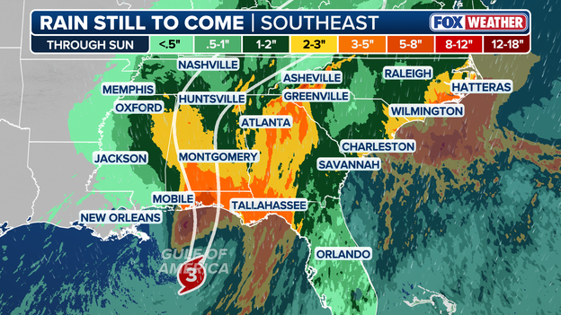
Latest rain forecast for the Southeast as Hurricane Isaias roars ashore
- Torrential downpours & flash flooding: Widespread rain totals of 2 to 5 inches are expected across much of the Southeast, Mid-Atlantic, and coastal Carolinas, with localized totals up to 10 inches—particularly along terrain-enhanced areas like the Southern Appalachians.
- Severe weather & tornadoes: The storm's eastern flank will remain dynamic through Saturday, keeping a risk of quick-hitting, embedded tornadoes active across Georgia and into the Carolinas.
- Coastal surge & high surf: Dangerous swells, strong rip currents, and elevated coastal water levels will extend along the Atlantic coastline as the remnant system interacts with other storm systems.
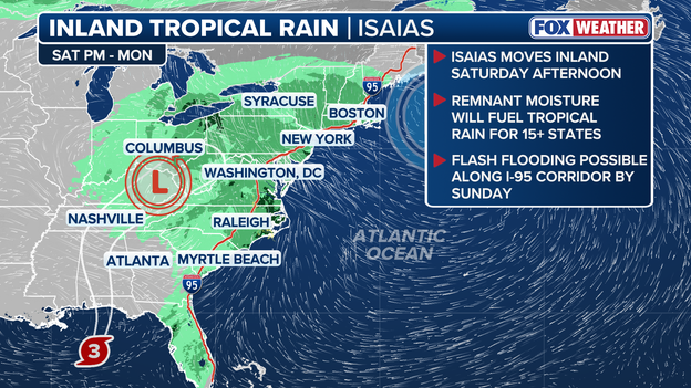
Rain from Isaias is expected to spread into the Northeast by Sunday
Call sign Teal 73 is airborne as the Air Force Reserve’s 53rd Weather Reconnaissance Squadron launches its sixth dedicated recon mission into Hurricane Isaias.
Flying directly into the eye and eyewall, these WC-130J aircrews are releasing dropsondes and measuring real-time flight-level winds, central pressure, and surface sea temperatures.
This live, high-resolution data feeds directly into National Hurricane Center forecast models, giving meteorologists ground-truth numbers to refine track, intensity, and storm surge guidance as landfall approaches.
Air Force Reserve Hurricane Hunter crews will maintain a continuous presence inside the storm, flying back-to-back missions until Isaias officially moves ashore.

U.S. Air Force C-130J aircraft are Hurricane Hunters, flying directly into hurricanes to track position, movement, and intensity
FOX Weather Hurricane Specialist Bryan Norcross says with maximum sustained winds holding at 120 mph and central pressure dropping to 959 mb, Isaias remains a formidable Category 3 major hurricane heading into its final hours over water.
With Hurricane Isaias now firmly within range of coastal Doppler radar sites, the National Hurricane Center has officially initiated hourly tropical cyclone updates.
Between the major full advisory packages, these hourly bulletins will provide high-frequency updates on the storm's exact eye position and movement speed.
Some uncertainty remains around the exact landfall location for Hurricane Isaias as forecast models present varying tracks.
The Google DeepMind AI weather model continues to pull noticeably farther east than traditional numerical models, placing its target closer to Miramar Beach, Florida.
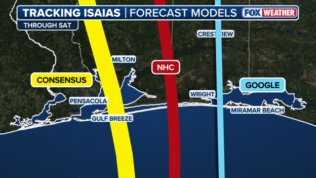
Computer forecast models show Isaias making landfall in Florida's Panhandle this evening
Meanwhile, the official National Hurricane Center forecast cone rests in the middle—splitting the difference between consensus guidance and the eastern AI track.
FOX Weather Hurricane Specialist Bryan Norcross is closely tracking every shift in the storm's satellite presentation and current position.
Norcross notes that Isaias is currently riding just slightly east of the official NHC forecast track.
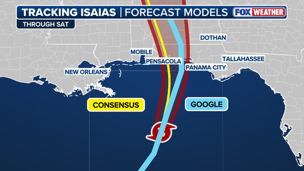
Official forecast track from the National Hurricane Center shows Isaias making landfall in the Florida Panhandle
If this subtle eastward drift persists through the afternoon, it could shift the core impacts and peak storm surge zone closer to Florida's Big Bend and western Panhandle, making real-time radar trends crucial to watch.
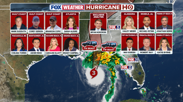
FOX Weather's team of experts, correspondents, and exclusive storm trackers is providing live coverage all weekend.
FOX Weather is providing continuous, 24/7 live coverage as Hurricane Isaias threatens the U.S.
Our team of meteorologists, correspondents, and exclusive storm trackers are stationed throughout the threat zone to deliver real-time radar analysis, critical warning updates, and on-the-ground reporting.
From field crews monitoring building storm surge at the shoreline to experts breaking down the storm's every move from America's Weather Center, we are dedicated to bringing you the ground truth before, during, and after the storm.
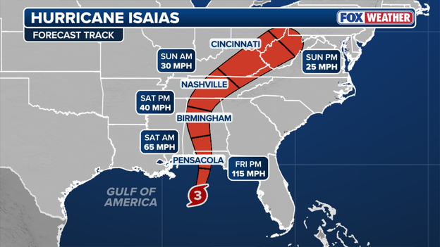
Latest forecast track from the National Hurricane Center
The National Hurricane Center's latest forecast track reveals a significant update: Hurricane Isaias may maintain its major Category 3 intensity all the way to landfall.
While earlier models indicated that incoming vertical wind shear would begin degrading the eyewall this afternoon, the storm's current forward speed and deeply organized core may allow it to hit the coastline before wind shear can fully disrupt the system.
The hurricane regional models (HAFS-A, HAFS-B, and HWRF), as well as the statistical-dynamical models (SHIPS and LGEM), all suggest that Isaias could maintain major hurricane intensity up until its landfall this evening.
If the eyewall holds together through landfall, coastal areas will face maximum sustained winds over 120 mph, dramatically increasing the risk of structural failure, long-term power grid destruction, and violent storm surge pushes.
Emergency officials stress that whether the storm arrives as a top-end Category 2 or holds as a major Category 3, life-threatening impacts are imminent, and all safety preparations must be completed immediately.
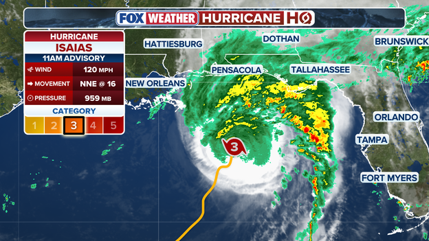
11 a.m. ET advisory from the National Hurricane Center
Fresh data from the National Hurricane Center’s 11 a.m. ET advisory confirms that Hurricane Isaias maintains solid Category 3 major hurricane strength, with maximum sustained winds holding at 120 mph and a minimum central pressure dropped to 959 mb.
The National Hurricane Center has officially issued its key 11 a.m. ET advisory, delivering updated positional data, maximum wind speeds, and an updated forecast track as Hurricane Isaias moves closer to the Gulf Coast.
Our team of meteorologists is actively combing through the numbers, assessing central pressure trends, storm surge inundation levels, and potential watch or warning adjustments.
Standby and stay tuned—we are breaking down the entire update in real-time over the coming minutes to bring you the latest on what this means as landfall nears.
Known across the South as an informal barometer for disaster severity, the infamous Waffle House Index uses the 24-hour diner's operational status to gauge a hurricane's destruction.
With 1,600 locations stretching from the mid-Atlantic to Florida and across the Gulf Coast, Waffle House operates directly in the heart of hurricane territory.

Elijah Nouvelage/Bloomberg via Getty Images
While most businesses focus on resuming normal operations after a disaster, Waffle House turns its crisis response into a core identity, bypassing traditional advertising to earn customer loyalty by remaining open when communities need hot meals and refuge the most.
A color-coded system—conceived by former FEMA administrator Craig Fugate—rates conditions as Green (full menu and power), Yellow (limited menu running on generator power), or Red (restaurant closed).
Because the chain goes to extreme lengths to stay open during severe weather, emergency management officials know that if a local Waffle House shuts down completely, the surrounding community has likely suffered catastrophic damage and requires immediate disaster relief.
Tide gauges along the northern Gulf Coast are already detecting measurable water rise well ahead of the storm's main center.
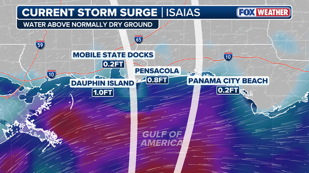
Latest storm surge data from along the Gulf Coast
Real-time observations show Dauphin Island, Alabama, is currently recording 1.0 foot of storm surge, while gauges in Pensacola, Florida, are logging 0.8 feet above normal tide levels.
While these initial increases may seem modest, they represent the early edge of the massive ocean volume being pushed toward the shoreline, and water levels will accelerate rapidly upward as onshore winds build and peak high tide approaches later today.
Video captured on the ground in Gulf Shores, Alabama, shows heavy surf churning along the shoreline, thick cloud cover overhead, and gusty winds rapidly building ahead of Hurricane Isaias.
Double red flags are flying prominently across local beaches, signaling to all residents and visitors that the Gulf of America is strictly closed to the public due to life-threatening waves and violent rip currents.
Beachgoers are urged to stay completely off the sand and out of the water as coastal conditions rapidly degrade ahead of the storm's arrival.
Double red flags are flying across Orange Beach, Alabama today as dangerous, life-threatening surf and powerful rip currents surge ahead of Hurricane Isaias.
We are just minutes away from the National Hurricane Center’s full 11 a.m. ET advisory.
This advisory will deliver updated central pressure readings, revised maximum sustained wind speeds, an updated forecast track cone, and official watch/warning adjustments across the Gulf Coast.
Our team of meteorologists is standing by to analyze the newly released coordinates, intensity trends, and storm surge grids, and we will break down all the vital updates and local impacts right here in real-time as soon as the data hits.
Florida Governor Ron DeSantis addressed residents today regarding the threat posed by Hurricane Isaias as the major Category 3 storm rapidly approaches landfall along Florida's Big Bend and Panhandle regions.
Emphasizing the storm's dangerous combination of major winds, life-threatening storm surge, and torrential rainfall, DeSantis urged all Floridians in the path to remain vigilant, heed local evacuation warnings, and stay acutely aware of rapidly changing conditions.
State emergency management teams and National Guard assets remain fully pre-positioned to assist local communities as the core of the storm moves ashore.
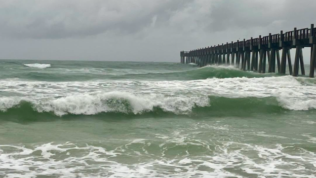
Pensacola Beach Lifeguards/Facebook
Emergency officials have ordered the immediate evacuation of Pensacola Beach, with lifeguards flying double red flags to signal that the Gulf is strictly closed to all water activities.
Heavy surf is already building past 6 feet, creating life-threatening rip currents as tropical force conditions accelerate toward the shore.
Lifeguards are officially clearing remaining visitors from the sand and heading off Pensacola Beach.
All residents and visitors are urged to pack up, move inland immediately, and stay completely out of the surf as dangerous coastal conditions deteriorate.

Exclusive analysis from FOX Weather Hurricane Specialist Bryan Norcross
Hurricane Isaias has intensified into a well-developed Category 3 hurricane and is making its move toward the Gulf Coast.
Thankfully, the upper-level winds are somewhat hostile, or it would have gotten a lot stronger like Milton did two years ago.
The peak winds will likely decrease a bit later today as the system approaches landfall, but it won't change the impacts significantly.
Damaging winds, storm surge, and rain heavy enough to cause flooding will affect the entire Florida Panhandle beginning late this afternoon, peaking this evening.
Early today is the last chance to maneuver before the weather starts deteriorating this afternoon.
Overnight, strong winds, which will likely knock out power, and torrential rain will spread into Alabama, Georgia, and eastern Mississippi.
Tornadoes will also be a threat in the outer bands north and well east of Isaias's center, including Tallahassee, North Florida, and into Georgia.
The El Niño-driven jet stream ripping across the south will morph the storm into something of a comma shape. The worst weather is likely to be ahead of the center of circulation and in the tail of the comma well to the east.
The jet stream will energize torrential rain, and tornadoes are possible in both the head and tail of the storm as it moves inland.
Strong wind gusts are likely over a wide area, including the entire State of Alabama and most of Georgia, especially near and to the east of where the center of Isaias tracks.
Bad weather will arrive well in advance of the center, which will cross the coast mid to late evening on the current schedule.
Thunderstorms are likely along the I-10 corridor this afternoon with the worst weather arriving in the evening.
The threat of heavy rain and tornadoes will continue through the night and into tomorrow as the comma-shaped hurricane pushes north.
The hurricane will merge with a large upper-level low-pressure system to spread tropical moisture across the Southeast.
The combo system will draw moisture from the Atlantic as well as the Gulf, elevating the flood threat along the Carolina coast in addition to higher elevations well inland. Stay aware of flood alerts issued for your area.
Isaias will push Gulf water over the coast along a large portion of the northern Gulf. The National Hurricane Center is forecasting the tide to be up to 7 feet above normal height around the time of landfall.
That assumes that landfall occurs around high tide time. If the tide is lower, obviously the impact would be a bit diminished, but there isn't much tidal swing on the northern Gulf beaches.
Tomorrow is a big football Saturday across the Southeast. If you are attending a game, consider carefully before getting on the road. Trees might be down, power might be out, and flooding rain is likely in some areas.
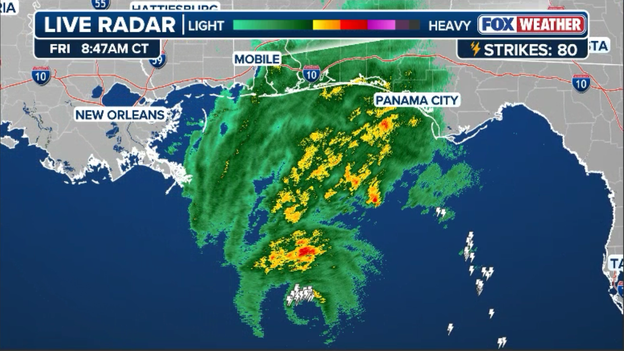
Isaias is now close enough for Doppler radar to show the storm's eye
NEXRAD Doppler radar sites along the northern Gulf Coast are now painting the inner structure of Hurricane Isaias, with the storm’s eye coming distinctly into radar range as the system closes the distance toward the shore.
Radar loops show the well-defined eyewall wrapping thick bands of torrential rain and high wind near the center, giving meteorologists continuous, high-resolution tracking of the storm's exact position and movement.
As the eye advances closer to the coast over the coming hours, the National Hurricane Center will begin providing hourly status updates as landfall nears.
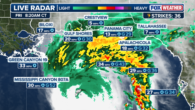
Radar shows heavy rain approaching the coast with wind speeds ramping up
Outer wind bands are beginning to make their presence felt along the northern Gulf Coast this morning, with observation sites already logging gusts approaching 30 mph.
These early squalls mark the leading edge of the storm's expansive wind field, and speeds will steadily build throughout the day as the system moves closer.
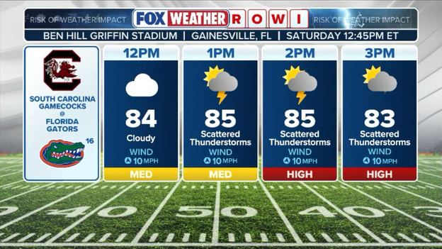
Latest Risk Of Weather Impact (ROWI) forecast for South Carolina vs. Florida
As tropical rainbands push inland, several college football matchups across the Southeast are facing a High ROWI (Risk Of Weather Impact) rating for Saturday’s game slate.
Downpours, gusty winds, and the threat of lightning delays will make ball security and footing a major factor, forcing teams to lean heavily on their ground games as conditions deteriorate.
Fans heading to stadiums across the impact zone should prepare for wet tailgating, potential game delays, and slick stadium concourses throughout the afternoon.
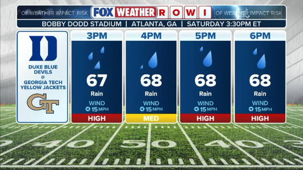
Latest Risk Of Weather Impact (ROWI) forecast for Duke vs. Georgia Tech
The FOX Forecast Center warns that widespread, long-duration power outages will surge across the Florida Panhandle and southern Alabama as high winds and tropical squalls batter the region through Saturday.
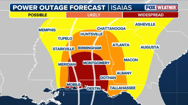
Latest power outage forecast from FOX Weather
Tropical downpours saturating the ground combined with damaging sustained winds will easily uproot trees and bring down utility lines across the core impact zone.
Residents in these communities should prepare for potentially extended grid failures by securing emergency power sources, charging necessary devices, and finalizing shelter preparations before conditions reach their peak.
As the storm moves ashore, the FOX Forecast Center warns of a rising risk of fast-moving tornadoes spinning up within outer rainbands across North Florida and into Georgia later today through Saturday.
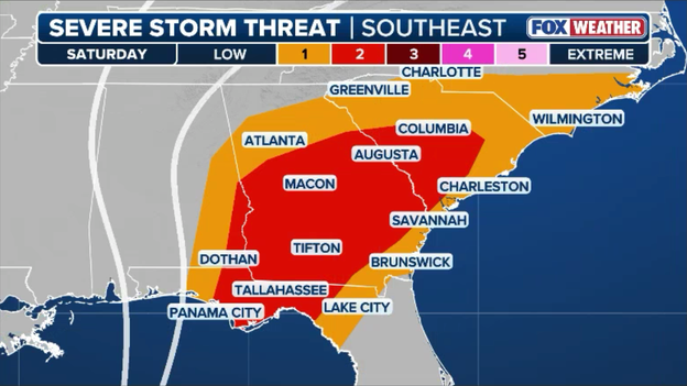
Tornado threat extends north and east on Saturday as Isaias spreads out
Tornadoes are extremely common in landfalling tropical systems because low-level friction over land slows surface winds while stronger winds aloft keep moving quickly, creating intense vertical wind shear.
This dramatic change in wind speed and direction with height tilts and rotates localized updrafts inside outer squalls, producing short-lived spin-ups that can form with little to no advance warning.
Residents across the region should keep emergency weather alerts active on their phones and identify a safe, interior room to shelter immediately if a tornado warning is issued.
The National Hurricane Center has updated its coastal inundation forecast, warning that storm surge could now reach a destructive 6 to 9 feet above normally dry ground between the Alabama/Florida border and Grayton Beach, Florida.
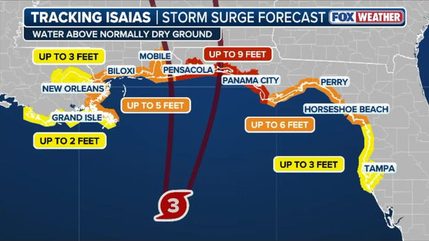
Latest storm surge forecast for Hurricane Isaias
This dangerous water would threaten severe coastal flooding across vulnerable beach communities, bayfronts, and low-lying roadways.
Bathymetry—the underwater topography or depth of the ocean floor—plays a critical role in determining how much water a tropical system can push onshore.
Along the Gulf Coast, a broad and exceptionally shallow continental shelf extends for miles out into the ocean before dropping off into deeper water.
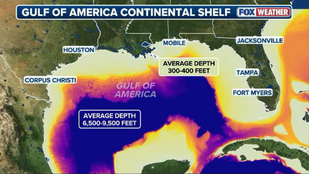
Gulf Coast Continental Shelf
In deep water, a hurricane’s powerful winds simply push surface water downward, allowing the ocean column to disperse energy vertically without building height.
However, when those same onshore winds hit the shallow shelf of the Gulf, the ocean floor acts as a barrier, preventing water from flowing downward and leaving it nowhere to go but up and inland.
This shallow underwater geometry acts like a massive ramp, allowing relatively moderate wind fields to stack up extraordinary volumes of water as storms push toward the coastline.
Coupled with local geographic features like concave bays, river mouths, and low-lying coastal marshes, this bathymetry turns the Gulf into one of the most storm surge-vulnerable basins in the world.
As the hurricane approaches, this unique underwater terrain is why forecasters emphasize water rise as the primary threat to life and property, far exceeding wind hazards in vulnerable coastal zones.
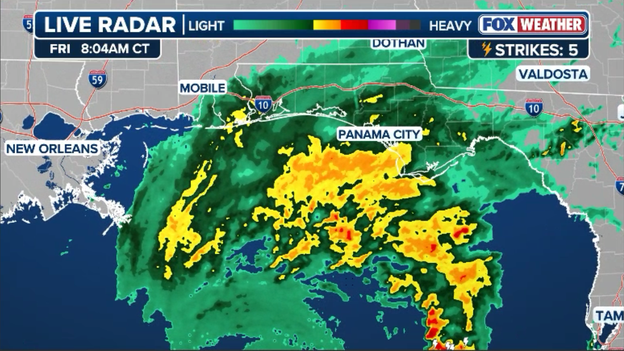
Radar image showing outer rainbands of Hurricane Isaias moving onshore
The system's outer rainbands are pushing onshore, unleashing torrential tropical downpours and gusty squalls across coastal communities well ahead of the storm's center.
These training bands are capable of dumping extreme amounts of moisture over the same areas repeatedly, leading forecasters to warn that localized rain totals could approach nearly a foot of rain in the hardest-hit spots.
Residents are urged to avoid travel along affected corridors, as these sudden deluge periods can rapidly fill low-lying roads and trigger dangerous flash flooding within minutes.
National Hurricane Center Director Dr. Michael Brennan joined FOX Weather live moments after the official upgrade to Category 3 status.
FOX Weather Meteorologist Michael Estime is on the ground in Mobile, Alabama, where crews are staging ahead of potential power outages and storm damage from Hurricane Isaias.
Although the system is currently churning at peak intensity, FOX Weather meteorologists expect a gradual weakening trend to begin this afternoon as the storm encounters a sharp increase in environmental wind shear.
Vertical wind shear refers to a change in wind speed or direction at different altitudes in the atmosphere.
For tropical cyclones—which require a symmetrical, vertically aligned core to efficiently process warm heat and moisture—strong wind shear acts like an atmospheric wrecking ball.
It tilts the storm's vertical stack, knocks the upper-level outflow out of alignment with the surface center, and injects cooler, drier air into the eyewall, effectively disrupting the internal engine fueling its intensity.
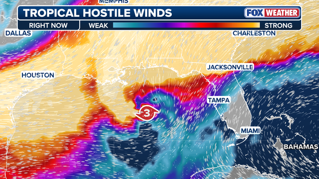
Hostile winds (wind shear) is expected to increase this afternoon, weakening Isaias ahead of landfall
However, forecasters emphasize that this late-stage disruption will not be a silver bullet for coastal communities. Because the system is starting from such a powerful baseline, it will take time for the atmospheric shear to significantly degrade the core structure.
As a result, the hurricane is still overwhelmingly projected to strike the coast as a dangerous, high-end Category 2 hurricane packing destructive sustained winds near 100 mph.
And even if peak surface winds begin to ease slightly, the storm's overall energy footprint, dangerous storm surge potential, and expansive heavy rain shield will not collapse overnight.
Residents across the forecast zone should not let down their guard, as severe structural damage, widespread power disruptions, and life-threatening coastal flooding remain fully locked in for landfall.
Crossing the threshold into a Category 3 storm officially elevates the system to "major hurricane" status on the Saffir-Simpson Hurricane Wind Scale.
The Saffir-Simpson scale classifies tropical cyclones strictly based on their maximum sustained wind speeds, with Category 3 encompassing winds from 111 to 129 mph.
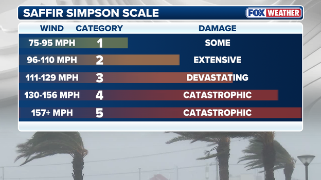
Saffir-Simpson Hurricane Wind Scale
This milestone matters because damage potential increases exponentially, not linearly, as wind speeds accelerate; major hurricanes packing Category 3 winds can tear roofs off well-built homes, snap or uproot most trees, and knock out power grids and municipal water infrastructure for days or weeks after landfall.
The official forecast calls for Isaias to begin weakening this afternoon, but the hurricane is still expected to be a dangerous Category 1 or 2 storm at landfall.
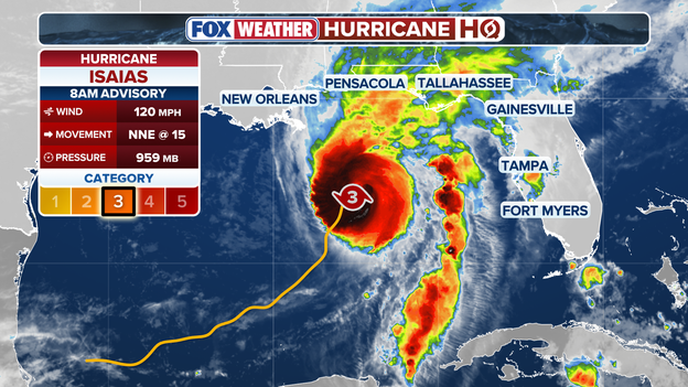
Special update from the National Hurricane Center
A special update from the National Hurricane Center confirms the storm has officially intensified into a major Category 3 hurricane.
Data gathered directly from Hurricane Hunter aircraft probing the core reveals maximum sustained wind speeds have climbed to 120 mph as the system pushes closer to landfall.
Hurricane Hunter aircraft have located the center of the storm just 240 miles south-southwest of Pensacola, Florida, as the system continues its steady push toward the northern Gulf Coast.
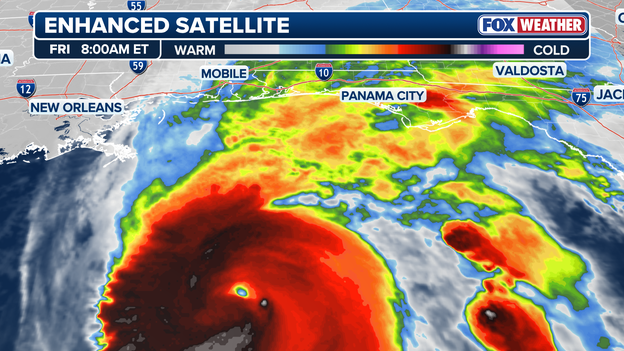
Latest high-resolution satellite image of Hurricane Isaias approaching the U.S. Gulf Coast
Tropical-storm-force winds already extend well outward from the core, meaning hazardous coastal conditions, heavy surf, and power disruption threats will arrive hours ahead of official landfall.
With the eye rapidly closing the distance, residents throughout the Florida Panhandle and southern Alabama have only a brief window left to finalize all life and property preparations.
The National Hurricane Center has updated its storm surge predictions, warning that dangerous water levels could now reach up to 9 feet above normally dry ground along vulnerable coastal areas.
The highest inundation of 6 to 9 feet is currently forecast for the stretch between the Alabama/Florida state line and Grayton Beach, Florida.
Significant, life-threatening flooding of 4 to 7 feet is also expected across surrounding coastal segments—including Mobile Bay, Dauphin Island, and the Florida Big Bend—making immediate evacuation essential before coastal roadways are submerged.
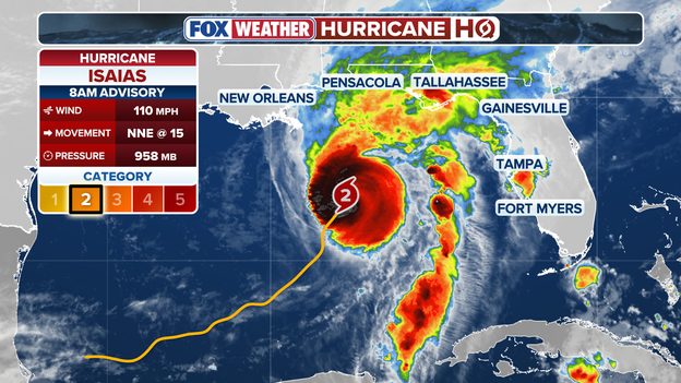
8 a.m. ET advisory from the National Hurricane Center
Hurricane Isaias is sitting on the very edge of becoming a major Category 3 hurricane, currently packing maximum sustained winds of 110 mph.
Under the Saffir-Simpson Hurricane Wind Scale, a tropical cyclone reaches major hurricane status once winds hit 111 mph, putting the storm just 1 mph shy of crossing that threshold.
With central pressure continuing to drop, forecasters caution that the storm is likely to officially achieve Category 3 status in the hours ahead.
The National Hurricane Center has officially released its 8 a.m. ET advisory, delivering updated wind speed measurements, pressure readings, and revised tracking coordinates for the storm.
Our team of meteorologists at the FOX Forecast Center is actively dissecting the newly released data, and we will break down the key takeaways and potential impacts right here in the coming minutes.
Data streaming back from Hurricane Hunter aircraft currently flying through the core reveals that central barometric pressure continues to fall, signaling that the storm is actively intensifying.
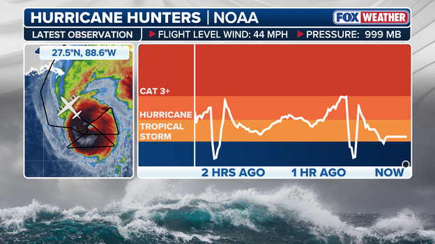
Latest Air Force reconnaissance data from the Hurricane Hunters flying through Hurricane Isaias
As internal pressure drops, the surrounding wind field accelerates, keeping meteorologists focused on whether sustained winds will officially break the 111-mph threshold for major Category 3 status.
All eyes remain on the upcoming 8 a.m. ET National Hurricane Center advisory to confirm the system's true intensity.
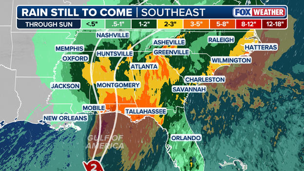
Rain forecast from Hurricane Isaias
Torrential rainfall is set to become one of the most widespread threats from the storm, with isolated pockets in the Florida Panhandle and Big Bend expecting totals as high as 15 inches.
This extreme volume of water will quickly overwhelm drainage systems, leading to severe flash flooding and swelling rivers that could remain high for days.
As the tropical system pushes inland and accelerates north and east over the coming days, its expansive rain shield will spread downpours across a massive footprint covering 26 states through Sunday.
Hurricane Hunters are flying through Isaias right now, relaying critical wind and pressure measurements back to forecasters ahead of the National Hurricane Center's 8 a.m. ET advisory.
This fresh reconnaissance data will determine whether the system has officially crossed the threshold into major Category 3 intensity, and we will post the full breakdown as soon as the updated numbers drop.
Emergency officials across Florida, Alabama, and Mississippi are warning residents in low-lying and coastal zones that the window of opportunity to safely evacuate is rapidly closing this morning.
With tropical-storm-force winds nearing the coast and life-threatening storm surge expected to flood critical low-lying roads and access routes, staying behind could leave families cut off from emergency responders once conditions peak.

Joe Raedle/Getty Images / Getty Images
Authorities urge anyone under mandatory or voluntary evacuation orders to finish finalizing their plans, secure their homes, and get to safer shelter immediately before outer rainbands completely deteriorate travel across the region.
The storm continues to intensify this morning thanks to a powerful atmospheric engine driven by upper-level divergence.
Upper-level divergence occurs when winds high in the atmosphere spread outward like an exhaust fan, rapidly pulling air upward from the ocean surface and causing central barometric pressure to drop.
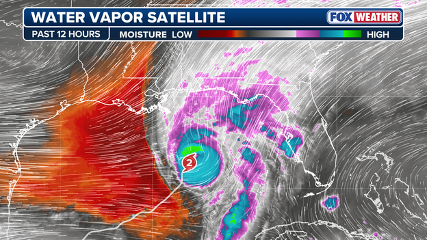
Upper-level winds are helping to ventilate the hurricane, allowing it to further intensify this morning.
At the same time, the hurricane is passing directly over the Loop Current, a deep reservoir of exceptionally warm ocean water in the Gulf.
Unlike shallow surface water that quickly cools under heavy winds, this deep pool of ocean heat acts as high-octane fuel, continuously feeding energy into the rising air column.
Together, these ideal upper-air and oceanic conditions are keeping the storm on a steady, dangerous strengthening trend ahead of landfall.
Hurricane Hunter crews are currently flying directly into the core of the storm, deploying specialized weather instruments called dropsondes into the eyewall to record real-time data on central barometric pressure, surface wind speeds, and temperature structure.
Because satellites cannot directly measure precise surface winds or internal pressure changes beneath dense cloud cover, this direct reconnaissance data is critical for forecasters at the National Hurricane Center.

The U.S. Air Force WC-130J is a specialized aircraft used to punch into dangerous hurricanes.
The flight observations are immediately fed into high-resolution computer models to pinpoint the storm's exact center, confirm whether wind speeds are accelerating toward major hurricane thresholds, and significantly refine local landfall track and intensity predictions.
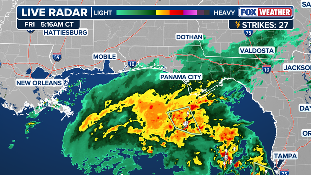
Latest radar image showing the outer rainbands of Isaias approaching the coastline
Outer rainbands from Isaias are nearing the Florida Panhandle and Big Bend region this morning, signaling the start of a prolonged stretch of hazardous weather.
Early morning radar shows persistent rain and gusty winds approaching the coast from the south.
These outer bands will move north through the morning, bringing localized downpours that can rapidly drop visibility and create hazardous driving conditions along major corridors like Interstate 10.
FOX Weather’s power outage forecast warns of widespread, long-duration blackouts as damaging tropical winds carve a path deep inland.
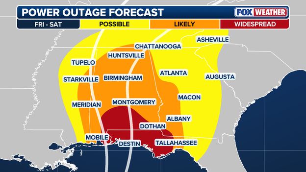
Latest FOX Weather power outage forecast
Coastal and near-coastal areas—including the Florida Panhandle and southern Alabama—face the highest risk of structural power line damage and prolonged grid failures.
However, the threat won't stop at the coast; strong gusty winds and saturated soils are expected to bring down trees and utility lines as far north as Tennessee and the mountainous terrain of western North Carolina.
Residents across these regions should prepare now for extended power loss by securing emergency supplies, charging necessary electronics, and preparing generator backup plans ahead of arrival.
FOX Weather meteorologists are closely tracking a continuous drop in central barometric pressure, which acts as the core engine driving the storm's steady intensification.
As the pressure at the center falls, the surrounding pressure gradient tightens sharply, forcing surrounding air inward at higher speeds and directly driving up sustained winds.
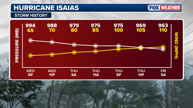
Hurricane Isaias is intensifying this morning with falling pressure and increasing wind speeds
This strong inverse correlation means that as long as barometric readings continue to plummet, the system will retain the energy needed to intensify further ahead of landfall.
Reconnaissance aircraft and coastal radar will remain focused on these pressure trends throughout the morning to gauge peak wind potential.
Governors across Florida, Alabama, and Mississippi have issued emergency declarations as the rapidly intensifying storm churns across the Gulf, threatening northern coastal communities with destructive winds, heavy flash flooding, and tornadoes.

Joe Raedle/Getty Images / Getty Images
Major school districts—including Escambia, Okaloosa, and Santa Rosa in Florida, alongside multiple counties in Alabama—have announced closures through Friday while local emergency teams deploy National Guard units, open shelters, and distribute sandbags to help residents safeguard their properties.
The best time to move sandbags is before people are standing in line for them. Our goal is to help communities get ahead of the weather, so residents and emergency crews have one less problem to solve when conditions deteriorate.
Favorable atmospheric conditions with warm ocean waters and low wind shear have fueled the storm's steady strengthening, leaving millions with only a narrow window to complete pre-landfall preparations.
With 6 to 10 inches of rain forecasted and empty grocery store shelves already reported from Pensacola to Mobile, officials urge residents not to wait for further track updates and to complete all emergency shelter plans immediately.
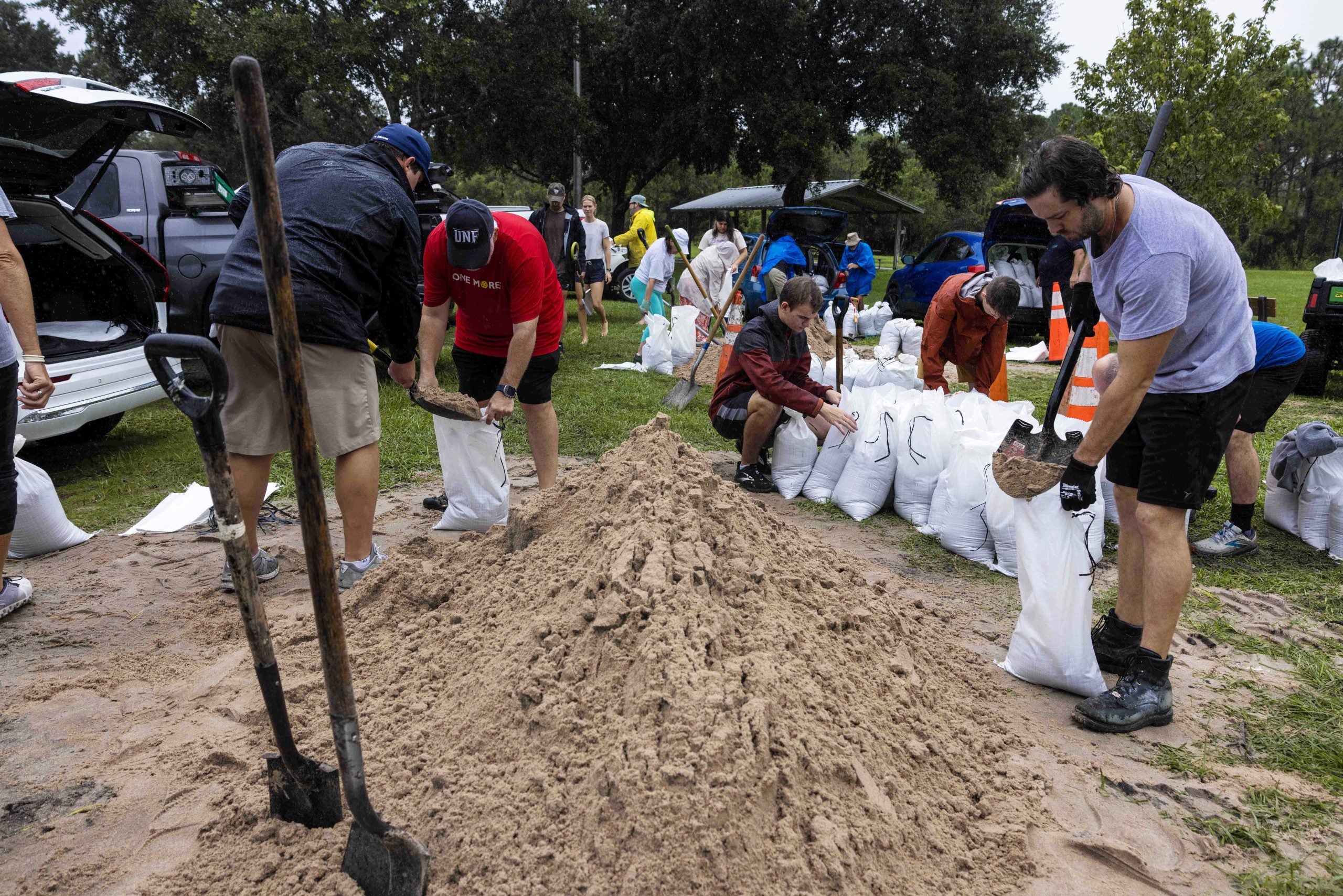
Packing 110-mph winds, the system is sitting right on the cusp of becoming a major Category 3 hurricane.
Under the Saffir-Simpson Hurricane Wind Scale, a storm transitions from Category 2 to Category 3 once sustained winds hit 111 mph, a threshold that marks a jump in potential destruction, structural damage, and power outages.
Hurricane Hunter aircraft are flying directly into the eyewall this morning to take precise pressure and wind measurements, and we'll provide updates on what they find as we get them.
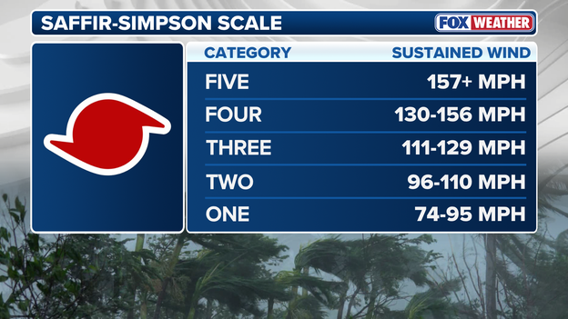
Saffir-Simpson Hurricane Wind Scale
FOX Weather Senior Correspondent Robert Ray is reporting live from Pensacola Beach, Florida, talking with residents as the dangerous storm closes in.
Dangerous winds and high waters will begin to lash the coast today, and Robert will be bringing you real-time updates and field analysis as the area braces for imminent landfall.
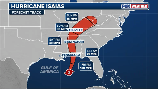
Latest forecast track from the National Hurricane Center
The National Hurricane Center's 5 a.m. ET advisory reflects a slight uptick in expected intensity, with NHC forecasters now predicting the storm will reach major Category 3 status later today as top sustained winds climb to 120 mph.
This upward adjustment in peak wind potential means coastal regions in the storm's path should prepare for heightened destruction, including life-threatening storm surge threat and severe structural wind risks at landfall.
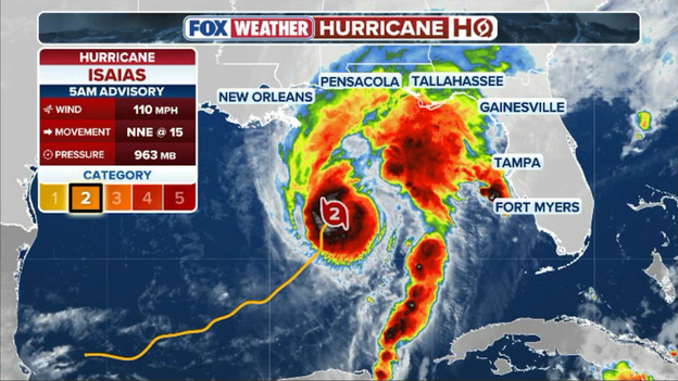
5 a.m. ET advisory from the National Hurricane Center
The 5 a.m. ET advisory reveals the storm is continuing to gain strength this morning, with maximum sustained winds now reaching 110 mph.
FOX Weather meteorologists warn that the storm's steady intensification brings heightened dangerous conditions, increasing the threat of destructive winds and severe coastal storm surge ahead of landfall.
The National Hurricane Center has officially released its 5 a.m. advisory, delivering updated coordinates, maximum sustained wind speeds, and revised pressure readings for the storm.
Our team of meteorologists is actively combing through the fresh forecast track and model guidance, and we will bring you full breakdown details and potential coastal impacts right here momentarily.
In case you missed it, Hurricane Isaias intensified into a dangerous Category 2 storm late Thursday night, packing 100-mph sustained winds as it continues its trek.
FOX Weather Hurricane Specialist Bryan Norcross delivered exclusive live analysis on the upgrade, breaking down what this increased strength means for coastal impacts, pre-landfall hazards, and storm surge expectations.
You’ve reached the beginning of this live coverage.