

Live updates: Deadly storms charge east threatening 65 million with intense tornadoes, huge hail
Live updates: Deadly storms charge east threatening 65 million with intense tornadoes, huge hail
Download the AppCoverage for this event has ended.
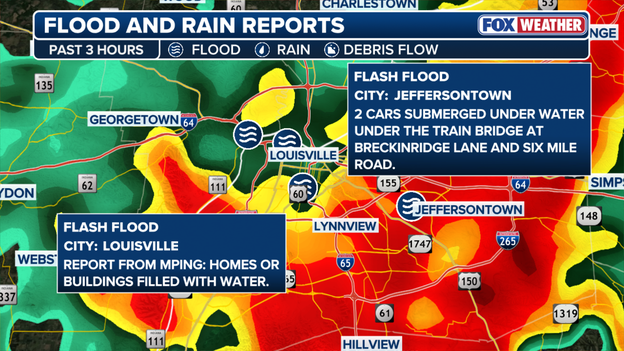
Flash flooding impacts parts of Kentucky as severe storms unfold across the state
It has been an active night of severe weather across the mid-South.
Outside of tornado warnings, parts of Kentucky are experiencing flash flooding as severe storms move through the region.
Officials have recorded nearly two inches of rainfall in the past three hours, with more expected.
In Louisville, KY, there have been reports of homes and buildings flooding, while in Jeffersontown, KY, officials reported two cars submerged in water according the National Weather Service.
Flash Flood Warnings have been issued for multiple counties across the state.
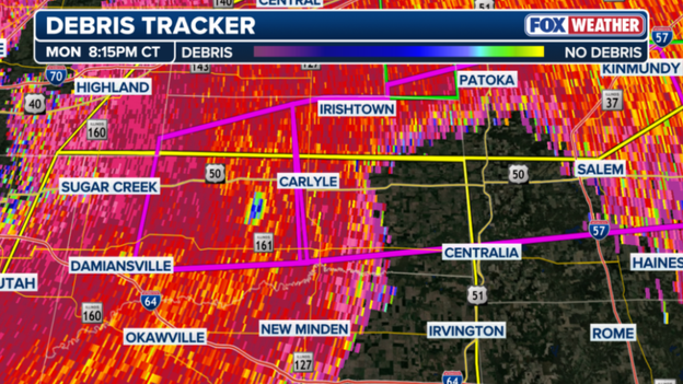
A PDS tornado heads toward Carlyle, Illinois.
A Particularly Dangerous Situation (PDS) is unfolding in the Carlyle, Illinois, area as a confirmed tornado moves through the area.
Anyone in the area should take shelter immediately.
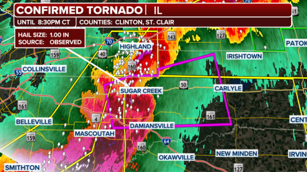
Confirmed tornado in Clinton County, Illinois.
A tornado has been spotted on the ground in the Sugar Creek, Illinois, area, and people in the area should seek shelter immediately.
Radar indicates the tornado is approaching a populated area, and a Tornado Warning is in effect through 8:30 p.m. CT.
Seeking shelter under an overpass is possibly one of the worst things you can do.
According to the National Weather Service, hiding out under a highway overpass during a tornado actually puts you at greater risk of harm.
You can get seriously injured by flying debris from the strong tornadic winds or even worse, killed.
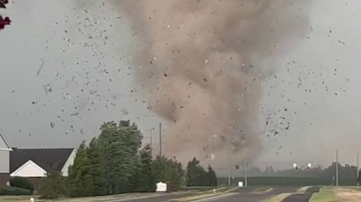
Flying debris can hurtle at incredible speeds, ranging in size, capable of penetrating clothing and skin, posing a serious risk of life-threatening injury or death.
One can even get blown or carried away in the intense tornadic winds, the NWS said.
And being under the narrow space beneath an overpass can actually increase wind speeds under the bridge.
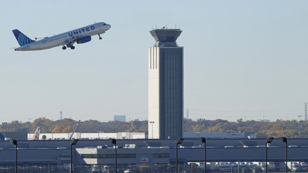
Massive delays being reported at Chicago O'Hare Airport.
Flights out of Chicago O'Hare International Airport are seeing massive delays due to severe storms in the area.
The airport is averaging flight delays of 210 minutes, according to the FAA.
There is currently a ground stop in effect, too, which will likely be canceled once severe storms subside.
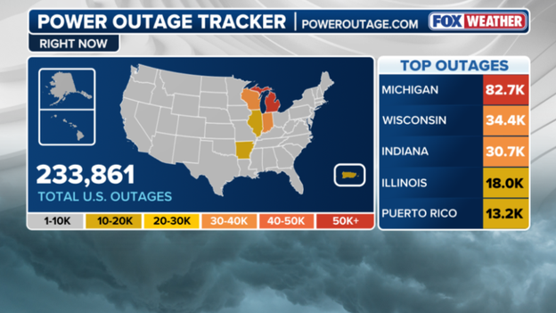
Over 225,000 customers without power as severe storms target the Midwest.
More households are without power as strong storms target the Heartland this evening.
Over 82,000 people are without power in Michigan, and Wisconsin is seeing over 34,000 outages as of 6 p.m., according to poweroutage.us.
Indiana doesn't fall far behind, with roughly 30,000 power outages reported.
Illinois is seeing a good chunk of customers without power, too.
Milwaukee Mayor Cavalier Johnson is providing an update after the city sustained damage due to an "unusual weather event" earlier today.
Cavalier said very strong winds have caused damage across the city, with officials receiving dozens of calls for help.
There have been reports of downed trees and branches, as well as thousands of households without power, Johnson said.
Port Milwaukee is assessing roof damage to two warehouses on its grounds due to the storms.
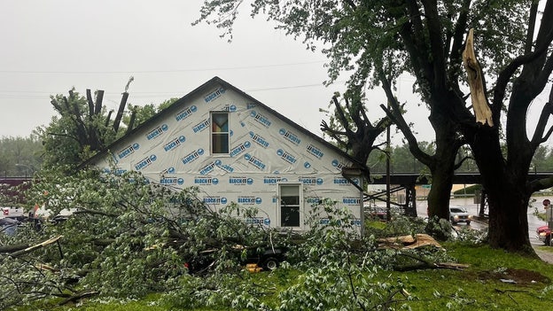
Extensive damage has been reported across Glasgow, Missouri.
A city in Missouri is dealing with the impacts of a tornado-warned storm system that left extensive damage in its path earlier today.
The City of Glasgow said the storms caused substantial damage including downed power lines, damage to buildings and roofs, as well as substantial damage to the water tower.
City officials went on to say that city streets have been nearly impossible to pass through.
Glasgow, Missouri, saw a series of severe storms pass through Monday morning, including a tornado-warned system around 7 a.m.
Photos from the Glasgow Fire District show extensive damage to buildings and homes across the city.
Tornadoes can happen in almost every state, and knowing what to do and where to go during a tornado warning can save your life.
As soon as a tornado warning is issued, seek safe shelter.
Shelter from a tornado can look many different ways, but there are many places to avoid, too.
Here are some tips to keep in mind as severe weather looms for millions.

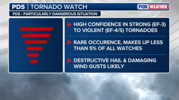
Here's what a PDS Tornado Watch means.
The Tornado Watch currently in effect for parts of the Midwest is classified as a PDS, meaning a Particularly Dangerous Situation is anticipated.
A PDS Tornado Watch means there's high confidence that strong (EF-3) to violent (EF4/5) tornadoes could form.
They're a rare occurrence, making up less than 5% of all watches, and destructive hail and damaging wind gusts are likely.
The most recent PDS Tornado Watch before tonight was issued on April 2, 2025, according to the FOX Forecast Center.
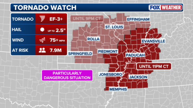
A Tornado Watch is expanded to include major cities include Memphis, Paducah and Jonesboro.
The Tornado Watch current in effect for portions of the Midwest has been expanded to cover nearly 8 million people.
Intense tornadoes (EF-3+) are possible for 7.9 million people in the risk area, which now includes major cities in Tennessee, Kentucky and Arkansas.
People in Memphis, Paducah and Jonesboro could now see wind gusts over 75 mph with hail up to 2.5 inches.
The Tornado Watch remains in effect through 9 p.m. CT.
While the main line of severe storms grabbed the headlines, it was a rare and invisible weather phenomenon known as a "wake low" that left nearly 50,000 customers in the dark across the Milwaukee metro area today.
This event is a meteorological wild card—it occurs on the backside of a departing rain shield, where sinking air creates a sudden, sharp drop in pressure.
The result? A localized "inland tsunami" of wind that can gust to 60 or 70 mph even while the sky is clearing.
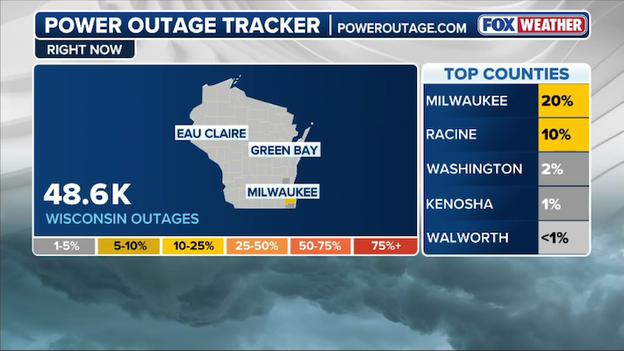
Power outage tracker for Wisconsin showing significant outages near Milwaukee. (PowerOutage.com)
The anatomy of a wake low
Think of a wake low like the wake behind a fast-moving boat. As the heavy rain and thunderstorms move out, the air behind the storm complex descends rapidly and warms. This creates a pocket of intense low pressure that sucks in air from the surrounding area, generating sudden, violent wind gusts.
In Milwaukee today, this meant that just as residents thought the worst was over, trees began snapping and power lines were brought down by wind gusts that rivaled the storms themselves.
Restoration challenges
We Energies and local utility crews are currently responding to hundreds of individual outage reports. The damage is widespread, with the heaviest concentration of outages in Milwaukee and Waukesha counties.
Because wake lows are often dry events—occurring without the lightning and thunder of a typical storm—they can catch both residents and utility sensors by surprise.
Crews are working as quickly as possible to restore power, but with more than 50,000 people currently in the dark, some may not see their lights return until later tonight.
If you are using a generator, please ensure it is placed outdoors and away from windows, and always treat any downed wire as live and life-threatening.
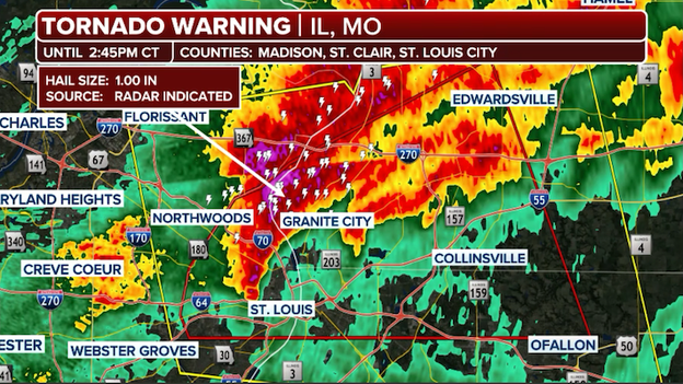
Doppler radar showing the Tornado Warning for the St. Louis, Missouri metro area.
For the second time today, the city of St. Louis is under a Tornado Warning as a dangerous storm moves directly over the metropolitan area.
The National Weather Service issued the warning for St. Louis City and portions of Madison and St. Clair counties in Illinois after radar indicated strong rotation within a storm located over the city at 2:01 p.m. CT.
This storm is moving east at 30 mph and is capable of producing both a tornado and quarter-sized hail. This is a life-threatening situation for those in the path.
In the heat of a severe weather outbreak, the terms "Tornado Watch" and "Tornado Warning" are often used interchangeably, but understanding the distinction is a critical part of your safety plan.
- A Tornado Watch means that the ingredients for a tornado are present in the atmosphere—think of it as having all the ingredients to bake a cake. During a watch, you should remain weather-aware, keep your phone charged, and know where your "safe spot" is, but you can generally continue your daily routine while keeping a close eye on the sky.
- A Tornado Warning , on the other hand, means the "cake is baked." This alert is issued when a tornado has actually been sighted by a spotter or indicated by weather radar. A warning is an immediate call to action; it means there is a direct threat to life and property.
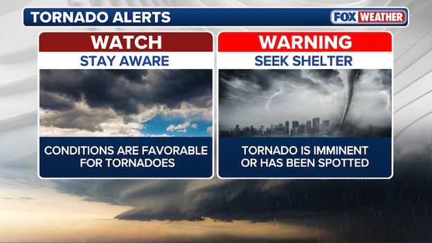
A Tornado Watch is issued when conditions are favorable for tornadoes to develop. A Tornado Warning is issued when a tornado is imminent or already occurring.
When a warning is issued for your specific location, you should stop what you are doing and move to your pre-determined safe room immediately. While a watch covers large regions for several hours, a warning is a localized, high-urgency alarm that typically lasts for 30 to 45 minutes.
The Storm Prediction Center is preparing to issue a new Tornado Watch for a broad swath of the Mississippi River Valley. This area—which includes northeast Arkansas, western Tennessee, western Kentucky, southeast Missouri, and southern Illinois—is entering a critical window where high-end severe weather is expected to erupt.
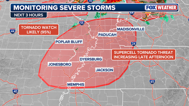
The Storm Prediction Center says a new Tornado Watch will be issued soon for areas where intense tornadoes are possible through the evening.
The latest technical discussions from forecasters highlight an incredibly volatile environment, noting that any storms that develop this afternoon could reach peak intensity with violent tornadoes (up to EF-4) possible.
This level of atmospheric energy is rarely seen and suggests the potential for long-track, devastating tornadoes that can stay on the ground for miles.
If you are in these areas, you should use the next hour to finalize your safety plans.
Ensure your shelter is accessible, your phone is charged, and you have multiple ways to receive warnings. This is a life-threatening situation that will likely persist well into the evening hours.
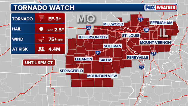
The Storm Prediction Center has issued a Tornado Watch for portions of Missouri and Illinois until 9 p.m. CT.
The Storm Prediction Center has just issued a Tornado Watch for eastern and southern Missouri—including the St. Louis metro—and southern Illinois, effective until 9:00 p.m. CT.
This isn't just a standard watch; the language used by forecasters is particularly urgent, noting that several tornadoes and a couple of "intense" tornadoes (EF-3 or stronger) are likely this afternoon.
This watch area is currently an atmospheric powder keg. A remnant boundary from this morning's rain is acting as a tripwire, allowing storms to explode as they tap into extreme heat and humidity.
- Tornadoes: Several are expected, with a high concern for long-track, intense tornadoes.
- Wind: Widespread damaging gusts up to 75 mph are likely.
- Hail: Scattered large hail is expected, with some stones potentially reaching 2.5 inches in diameter (tennis ball size).
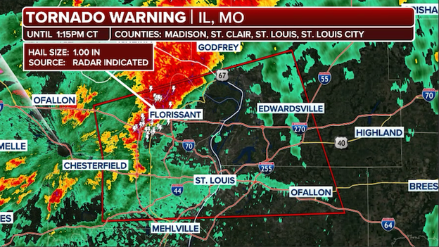
The National Weather Service has issued a Tornado Warning for St. Louis until 1:15 p.m. CT.
The National Weather Service has issued a Tornado Warning for St. Louis City, St. Louis County, and portions of Madison and St. Clair counties in Illinois until 1:15 p.m. CT.
At 12:27 p.m., a severe thunderstorm capable of producing a tornado was located over Maryland Heights, moving east at 40 mph.
This dangerous storm is heading directly toward the core of the St. Louis metropolitan area. If you are in the path of this storm, you must take action immediately to protect your life.
The severe weather threat is entering its most dangerous phase right now as storms across Missouri begin to become surface-based. While earlier storms were elevated above a cooler layer of air, the sun has successfully heated the ground, allowing new thunderstorms to tap into the raw energy and twisting winds right at the surface—the key ingredient for tornado formation.
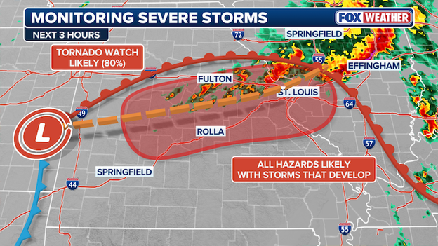
The Storm Prediction Center is likely to issue a Tornado Watch stretching across Missouri, including St. Louis, in the next hour or two.
As this cap on the atmosphere breaks, the FOX Forecast Center expects the Storm Prediction Center to issue a Tornado Watch for portions of Missouri within the next hour or two. This watch will likely cover the area from central Missouri through the St. Louis metro, signaling that conditions are officially primed for the development of intense, rotating supercells.
If you are in this region, this is your final window to ensure your safe spot is ready before the first warnings begin to fly.
The forecast for today’s severe weather outbreak has officially been narrowed down, and the latest data has placed a bullseye directly over eastern Missouri—including the St. Louis metro—and western Illinois.
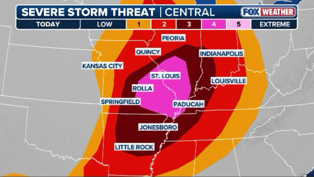
Dangerous storms are forecast to erupt across the Heartland this afternoon with intense tornadoes, huge hail, and damaging winds all possible.
FOX Weather meteorologists are now highly confident that this region will serve as the primary firing range for discrete supercells this afternoon. These individual storms will be tapping into a high-octane environment specifically primed for intense, long-track tornadoes (EF-3 or stronger).
What has changed in the last few hours is the outflow boundary from morning storms across Missouri. South of this boundary, the sun is rapidly heating the ground, creating a perfect match between surface instability and powerful, twisting winds aloft.
This creates a high-stakes window between 2:00 p.m. and 10:00 p.m. CT where the risk of a significant tornado is at its highest.
If you are in the St. Louis area or western Illinois, this is no longer a broad possibility—it is a focused threat. Ensure your shelter is ready and your phone alerts are at maximum volume, as storms in this honed-in corridor will be moving fast and packing immense power.
The forecast for the St. Louis metropolitan area is particularly complex this afternoon due to the outflow left behind by this morning’s storms across Missouri.
In meteorology, outflow acts like a mini-cold front, pushing cooler, more stable air across the region; while this can sometimes act as a shield that limits storm intensity, these remnant boundaries can also serve as a literal collision point for new storms to erupt.
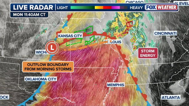
Surface analysis showing an outflow boundary draped across Missouri thanks to thunderstorms charging across the state.
If the sun can break through the remaining clouds and re-prime the air south of these boundaries, St. Louis could find itself in the crosshairs of explosive storm development.
Regardless of how these morning clouds play out, FOX Weather meteorologists emphasize that residents should not let their guard down. The presence of these invisible boundaries actually increases the spin in the lower atmosphere, which can make any supercell that does form even more likely to produce a tornado.
Whether the atmosphere stays capped or turns volatile, the margin for error is razor-thin today, making it a high alert situation for everyone in the metro area through the evening.
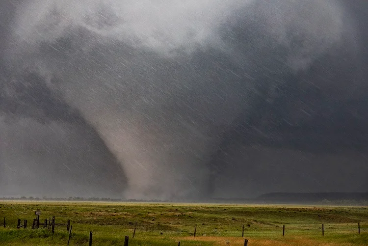
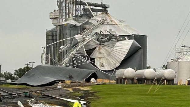
(Missouri Highway Patrol)
The Missouri State Highway Patrol (MSHP) is actively monitoring conditions across the region after severe weather lashed the Kansas City metro and surrounding areas.
This morning, troopers have been responding to various weather-related incidents, including reports of standing water on roadways and damage as the first wave of intense storms moved through.
MSHP officials are urging motorists to remain vigilant, especially in areas prone to flash flooding, following the Kansas City Fire Department's response to multiple water rescues earlier today.
With more storms expected this afternoon, MSHP continues to emphasize the "Turn Around, Don't Drown" message and encourages residents to stay off the roads if possible as the threat for significant tornadoes and damaging winds increases.
The Heartland is currently staring down the barrel of a tornado outbreak as a volatile atmospheric setup reaches its breaking point.
The Storm Prediction Center has taken the rare step of upgrading a broad corridor—spanning from eastern Missouri through central and southern Illinois—to a Level 4 out of 5.
This isn't just your typical spring storm; meteorologists are warning of a "high-end" event capable of producing multiple strong to intense tornadoes (EF-3 or higher), baseball-sized hail, and hurricane-force wind gusts.
The setup: A perfect storm of ingredients
What makes today particularly dangerous is the perfect match of atmospheric fuel and wind energy. A powerful low-pressure system is currently pulling a surge of high-octane, humid air from the Gulf of Mexico directly into the path of an intensifying jet stream.
This creates extreme wind shear—the changing of wind speed and direction with height—which is the primary engine that allows thunderstorms to begin rotating.
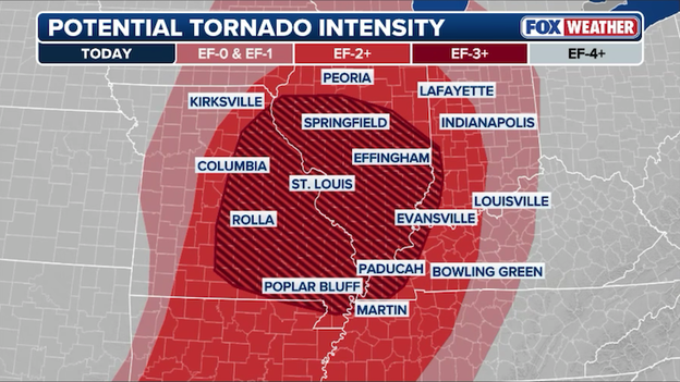
Intense tornadoes (EF-3 or stronger) are expected this afternoon across portions of Missouri and Illinois.
The timing: The afternoon eruption
While morning clouds provided a temporary shield, that protection is quickly eroding. As the sun breaks through this afternoon, it will act as a match to a powder keg, priming the air with massive amounts of storm energy.
Forecasters expect discrete supercells to erupt between 2:00 p.m. and 10:00 p.m. CT. Unlike a solid line of storms, these individual cells are more dangerous because they can spin uninterrupted for hours, often tracking across multiple counties.
Cities in the crosshairs
The bullseye for the most significant activity includes:
- St. Louis, MO
- Springfield and Decatur, IL
- Cape Girardeau, MO
- Paducah, KY
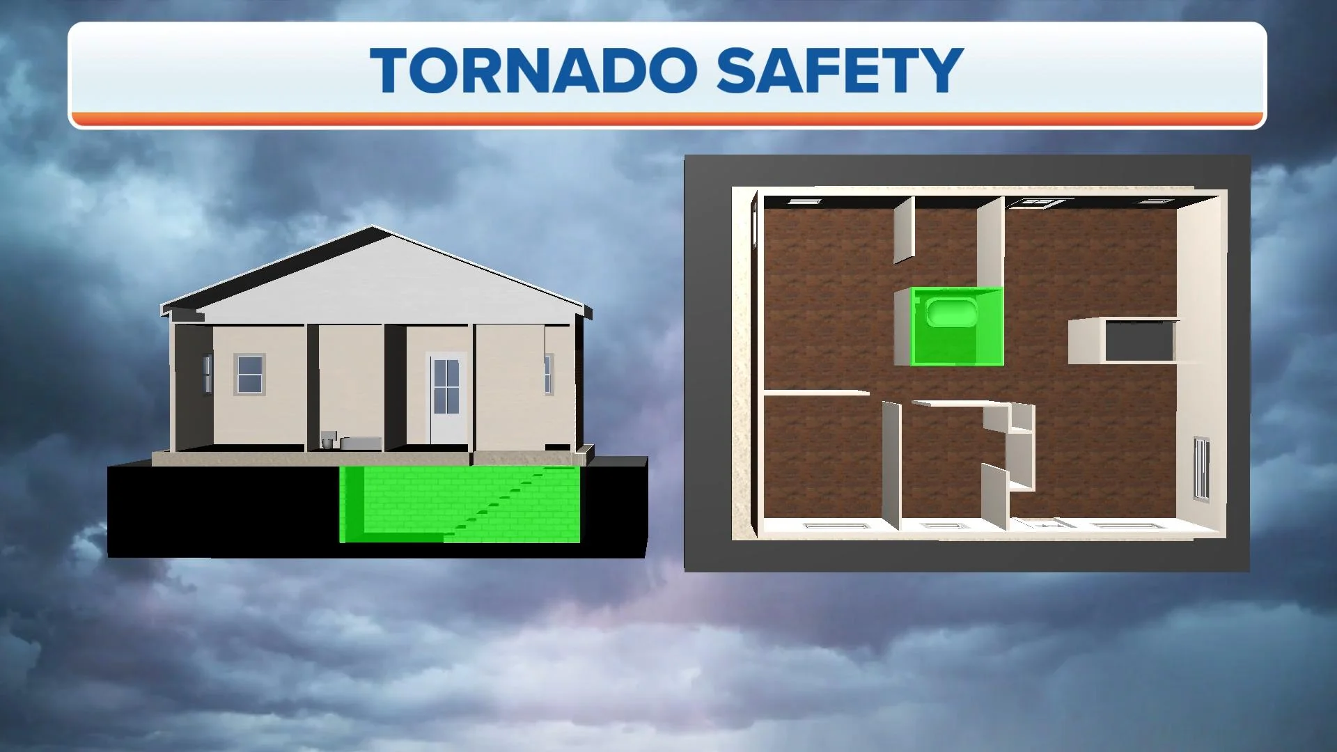
If you live in these areas, now is the time to review your safety plan. Ensure your phone is not on "Do Not Disturb," have a fresh set of batteries in your weather radio, and know exactly which interior room or basement you will head to the moment a warning is issued. This is a day where playing it safe could be the difference between life and death.
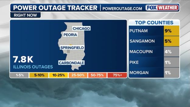
Latest power outage tracker showing the number of customers without power across Illinois. (PowerOutage.com)
The number of power outages in Illinois is climbing rapidly as the first wave of severe weather sweeps across the state, with more than 7,000 customers now reported to be without electricity.
The bulk of these outages are concentrated in central Illinois, where wind gusts as high as 70 mph have been downing tree limbs and damaging utility equipment.
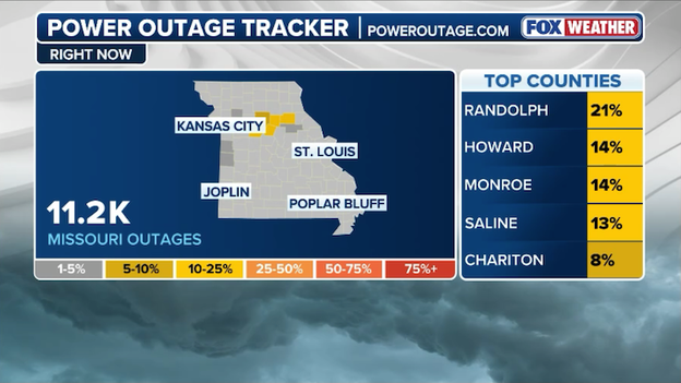
Latest power outage tracker showing the number of customers without power across Missouri. (PowerOutage.com)
The first round of severe thunderstorms has left a significant mark on Missouri’s power grid, with more than 11,000 customers currently without electricity across the state.
The outages are largely concentrated in Mid-Missouri and areas near the Kansas City metro, where damaging winds and frequent lightning strikes took down utility poles and tree limbs throughout the morning hours.
Utility companies, including Evergy and local electric cooperatives, have crews in the field working to restore power as quickly as possible.
As the morning rain clears, a invisible but powerful process called atmospheric recovery is underway across the Heartland. The sun is currently working to heat the ground and destabilize the air, rapidly building up CAPE (Convective Available Potential Energy)—the "fuel" that thunderstorms use to explode into the upper atmosphere.
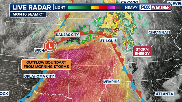
Analysis of the atmosphere showing where instability is increasing south of a warm front draped across the Midwest at this hour.
In the next few hours, this surge in energy, combined with a strengthening low-level jet, will create a volatile environment where any storm that breaks through the cap could turn tornadic in a matter of minutes.
FOX Weather meteorologists are watching the thermometer and dew point readings like a hawk right now, as every degree of warming adds more power to the afternoon's potential.
This building energy is what transforms a standard thunderstorm into a dangerous supercell; with energy levels expected to peak between 2 p.m. and 6 p.m. local time, this afternoon's window represents the most high-stakes portion of the entire weekly stretch.
Stay vigilant, as this recharge phase is the final ingredient needed for what could be a high-end severe weather event.
A powerful storm has caused substantial damage across the community of Glasgow in Howard County.
Local officials have been forced to close Highway 5 in both directions between 1st Street and Saline Street due to multiple downed power lines draped across the roadway.
The Howard County Sheriff’s Office and utility crews are currently on the scene assessing the destruction.
This portion of the highway is expected to remain closed for at least the next 1 to 2 hours as teams work to clear debris and restore power.
Residents are being urged to avoid the area and seek alternate routes as these storms continue to pack a punch across Mid-Missouri.
The atmosphere surrounding the St. Louis metro is becoming increasingly volatile.
Meteorologists are tracking a surge of moisture—noted by dew points climbing into the upper 60s—colliding with powerful, twisting winds in the upper atmosphere.
The environment is forecast to be absurdly strong...
This combination creates a high-octane environment where any storm that develops can quickly become a supercell, the most dangerous type of thunderstorm capable of producing intense, long-track tornadoes and baseball-sized hail.
Because these favorable conditions are overlapping directly over the metropolitan area, the window between 2 p.m. and 8 p.m. local time is particularly critical for the development of life-threatening weather.
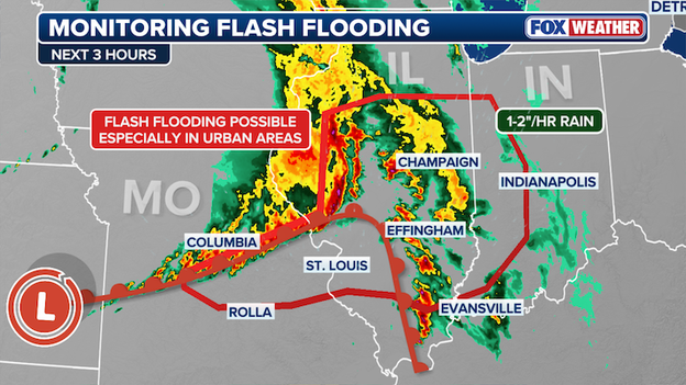
The FOX Forecast Center says flash flooding will remain a concern for portions of Mid-Missouri into Illinois through early afternoon.
While the threat of tornadoes often grabs the most attention, a dangerous flash flooding situation is steadily progressing across the heart of the Midwest.
A line of severe thunderstorms is currently pushing through central Illinois and into the St. Louis metropolitan area, dumping rain at a staggering rate of 1 to 2 inches per hour.
When storms train—meaning they follow the same path over the same neighborhoods like cars on a railroad track—rain totals can quickly skyrocket to 3 inches or more, making it impossible for storm drains to keep up.
The FOX Forecast Center is closely monitoring storms stretching from west-central Missouri into Illinois that are expected to linger along the I-70 corridor through the afternoon.

Because the ground is already saturated from morning rain, any additional downpours will likely run off immediately, creating a high risk for significant urban flooding in cities like St. Louis and Springfield.
If you encounter a flooded roadway, remember that it only takes a few inches of moving water to sweep a vehicle away; play it safe and find an alternate route.
Kansas City has experienced a staggering deluge over the last 24 hours, recording nearly a full month's worth of rain in a single day.
The torrential rain saturated the ground and overwhelmed local infrastructure, leading to the widespread flash flooding and high-water rescues seen across the metro area this morning.
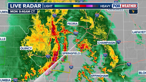
Severe thunderstorms are blasting Illinois with wind speeds up to 70 mph, small hail, torrential rain, and even a few potential tornadoes.
A powerful line of severe thunderstorms is currently blasting through central Illinois, bringing the immediate threat of damaging wind gusts up to 70 mph.
This bowing segment of storms is moving rapidly eastward, prompting a flurry of warnings as it pummels communities with torrential rain and hail up to two inches in diameter.
Emergency officials are urging residents to stay indoors and away from windows as the leading edge of these storms crosses the state.
Weather balloons are high-altitude balloons equipped with a specialized instrument package called a radiosonde, which measures vital atmospheric data as it ascends.
During its flight, the balloon continuously transmits real-time information on temperature, humidity, and air pressure, while its movement allows meteorologists to track wind speed and direction at different heights.
We rely heavily on these launches because they provide a vertical slice of the atmosphere that satellites and ground stations simply cannot capture in such detail.
By understanding these upper-air conditions, forecasters can identify the exact "ingredients"—such as wind shear and instability—needed for tornadoes to form, making weather balloons an indispensable tool for providing accurate and timely warnings during severe weather outbreaks.
In response to the rapidly deteriorating weather forecast, St. Louis Public Schools have announced an early dismissal for all students and staff today.
To ensure the safety of the community before the most dangerous storms arrive, all schools will close two hours earlier than their regularly scheduled time.
Central Office operations will conclude at 3:00 p.m., followed by maintenance and security personnel at 4:00 p.m.
District officials confirmed that transportation services will be adjusted to match these new dismissal times and will remain in operation until every student has been safely delivered to their destination.
Parents and caregivers are encouraged to make necessary arrangements immediately as the city prepares for a high-end severe weather threat this afternoon.
Rounds of severe thunderstorms triggered flash flooding, prompting water rescues across Kansas City, Missouri early Monday, ahead of an even more dangerous threat this afternoon.
The Kansas City Fire Department said it has made at least 11 rescues from high-water areas as of this morning. Responding crews were able to move motorists from their vehicles to dry ground without the need for boats, and thankfully, no injuries were reported.
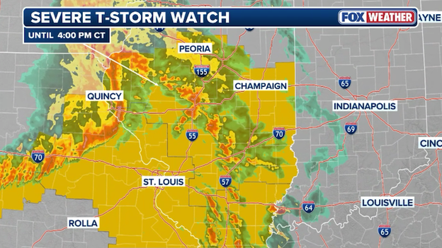
The Storm Prediction Center has issued a Severe Thunderstorm Watch for central and southern Illinois until 4 p.m. CT.
The Storm Prediction Center has issued a Severe Thunderstorm Watch for a large portion of central and southern Illinois, effective until 4:00 p.m. CT today.
Forecasters are tracking a bowing line of storms that is expected to gain strength as the atmosphere warms and destabilizes throughout the afternoon.
The primary threats within this watch area include scattered damaging wind gusts up to 70 mph and large hail, with some stones potentially reaching 2 inches in diameter.
While wind and hail are the main concerns with this initial cluster, an isolated tornado or two cannot be ruled out as the system pushes eastward through the state.
When a Tornado Warning is issued, seconds count, and your first priority is to put as many walls between you and the wind as possible.
The safest place to be is an underground storm cellar or a basement; however, if those aren't available, move to the lowest floor of a sturdy building and seek out a small, interior room without windows, such as a closet, hallway, or bathroom.
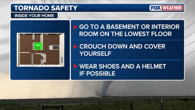
If a Tornado Warning is issued for your area, your first priority is to put as many walls between you and the wind as possible.
It is vital to remember that mobile homes and vehicles are never safe during a tornado, regardless of how they are anchored or parked.
If you are in a mobile home, you must evacuate to a pre-identified sturdy shelter immediately.
If you are caught on the road and cannot reach a building, your last resort is to park your car, keep your seatbelt on, and duck below the windows while covering your head with a blanket or your hands—or, if a significantly lower area like a ditch is available, exit the vehicle and lie flat there to let debris pass over you.
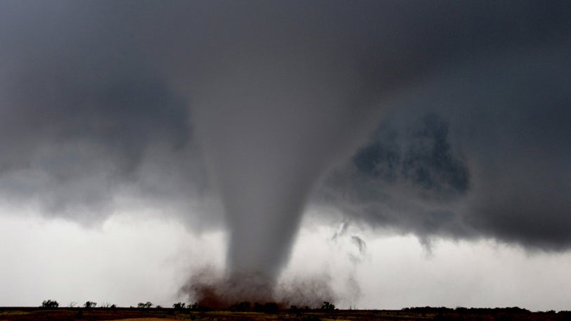
FOX Weather meteorologists Melanie Black and Marissa Torres are providing a deep dive into today’s significant threat escalation, following the Storm Prediction Center’s move to a Level 4 Risk.
The duo broke down the complex atmospheric ingredients coming together over the Mississippi Valley, explaining how the morning’s cloud cover is the "wild card" that could either fuel or dampen the potential for long-track tornadoes.
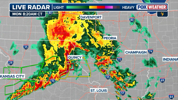
Radar showing a line of severe thunderstorms crashing east across Illinois and Missouri this morning.
A powerful line of thunderstorms is currently crashing through Mid-Missouri, bringing a barrage of heavy rain and damaging wind gusts to the region. These storms are part of a broader morning wave that is steadily tracking east along the I-70 corridor, with the leading edge now pushing toward the Illinois border.
As these storm clusters move into Illinois, they are bringing the threat of 60 mph winds and localized flash flooding to areas like Jefferson City and Quincy.
Forecasters are closely watching this activity, as the rain and cloud cover left in its wake will play a critical role in determining how much the atmosphere can reload for a more significant severe weather outbreak expected later this afternoon.
When a tornado tears through a community, the first question often asked is, "How strong was it?"
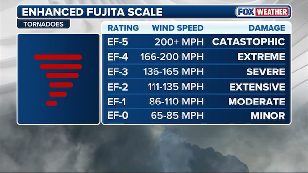
Meteorologists use the Enhanced Fujita Scale to determine the strength of tornadoes based on the damage it produces.
To answer this, meteorologists use the Enhanced Fujita (EF) Scale, which became the official standard in the United States in 2007.
Unlike a hurricane's strength, which can be measured in real-time by aircraft or satellites, a tornado’s wind speed is almost always estimated after the fact.
Because most wind-measuring instruments are destroyed by a tornado's path, experts must work backward, acting as "weather detectives" to analyze the destruction left behind.
The process begins with a ground survey conducted by National Weather Service (NWS) experts. These teams examine "Damage Indicators"—a list of 28 specific structures and objects, ranging from small barns and residential homes to high-rise buildings and even hardwood trees.
By looking at how these indicators held up—for example, whether a house merely lost some roof shingles or was wiped clean off its foundation—surveyors can assign a Degree of Damage (DOD).
This DOD corresponds to a specific wind speed range. For instance, if a well-built home is completely leveled, it suggests wind speeds typical of an EF-4 or EF-5.
It is a common misconception that a tornado's physical size or its appearance on radar determines its rating; in reality, a massive "wedge" tornado that hits an open field may only be rated an EF-0, while a small, thin "rope" tornado that hits a town can receive a much higher rating based on the structures it impacts.
This meticulous survey process ensures that every tornado is categorized accurately, helping engineers build safer structures and helping meteorologists better understand these violent storms.
Today marks 15 years since the catastrophic April 27, 2011, Super Tornado Outbreak, a day that remains the deadliest and most destructive severe weather event in modern American history.

A US flag is seen next to a destroyed home in the Holt neighborhood of Tuscaloosa, Alabama May 1, 2011. Many trailer homes in the area were destroyed by the tornado which struck April 27. (MANDEL NGAN/AFP via Getty Images)
Over the course of that tragic Wednesday, a staggering 360 tornadoes touched down across 26 states, claiming 321 lives—including 240 in Alabama alone—and forever transforming cities like Tuscaloosa and Birmingham.
As communities across the South pause to remember the lives lost and the $12 billion in damages incurred, the milestone serves as a somber backdrop to today's active weather.
While today's setup in the Midwest is not expected to reach the historic scale of 2011, meteorologists note that the 2011 outbreak remains the ultimate benchmark for atmospheric volatility, reminding residents of the critical importance of being weather-ready during the spring season.
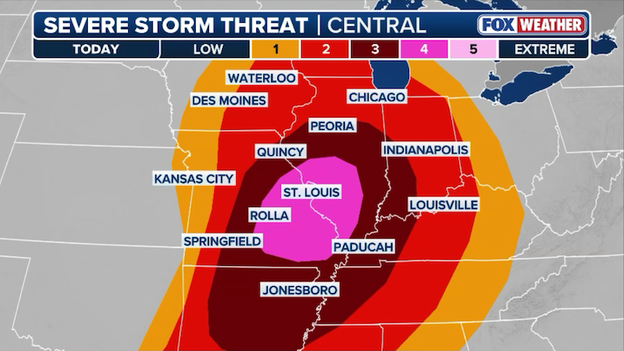
The Storm Prediction Center has issued a Level 4 of 5 severe weather threat zone for portions of Illinois and Missouri in anticipation of dangerous severe weather today.
The Storm Prediction Center has officially upgraded the threat level to a Level 4 out of 5 for a corridor including St. Louis, eastern Missouri, and large portions of western and central Illinois.
This escalation reflects growing confidence in a high-end event, where atmospheric conditions are becoming dangerously supportive of intense, long-track tornadoes and baseball-sized hail.
The FOX Forecast Center notes that this upgrade specifically targets areas where the morning cloud cover is expected to clear the fastest, allowing the atmosphere to reach maximum instability by late afternoon.
For residents in the new upgraded threat zone, this represents a dangerous situation where multiple intense tornadoes (EF-3 or higher) are now considered probable after 2 p.m. ET.
The Kansas City Fire Department has been on the front lines of this morning’s flash flooding, responding to 11 water rescues beginning just before 6 a.m. CT.
Most of these incidents were concentrated in the city's notorious high-water areas, where responding crews were able to assist drivers from their vehicles and lead them to dry ground.
Fortunately, no boats were required for these operations, and officials report that there have been no injuries or ambulance transports as a result of the flooding so far.
While the ingredients for a significant outbreak are present, there are a few saving graces that could significantly diminish the danger.
The most critical factor is the lingering impact of this morning’s rain and cloud cover; if the clouds fail to break by early afternoon, the sun won't be able to recharge the atmosphere with the heat needed to fuel explosive supercells. This would leave the air mass more stable and potentially capped, preventing the most dangerous storms from ever reaching their full tornadic potential.
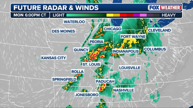
Future radar showing where severe storms are expected to develop later this afternoon across the Heartland.
Additionally, the early arrival of the main storm line could be a hidden blessing. If the morning clusters of rain push further south than expected, they could effectively rob the region of the moisture and energy required for intense tornadoes.
For millions across the Midwest, a persistent grey, rainy afternoon would be the best-case scenario, as it would act as a wet blanket on the volatile setup and keep the most destructive winds and tornadoes from developing.
While the Heartland has endured a relentless stretch of severe weather over the last several days—including a destructive EF-4 in Oklahoma this past weekend—today’s setup carries a unique and more dangerous signature.
The primary driver is the sheer volatility of the air mass currently surging into the Mid-Mississippi Valley. Unlike previous rounds that were hampered by limited moisture or weaker wind shear, today features a perfect match of high-octane instability and a powerful low-level jet.
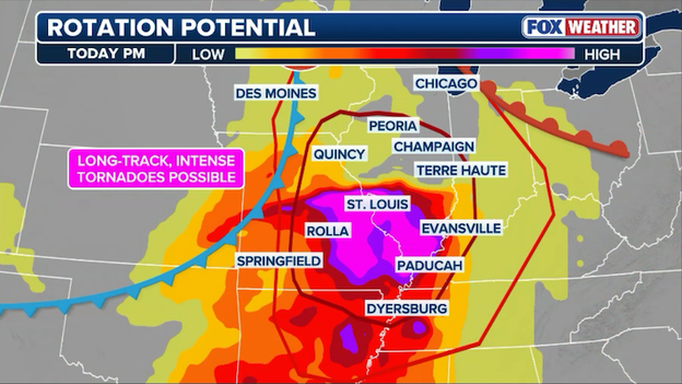
Dangerous long-track, intense tornadoes will be possible this afternoon across Missouri and Illinois.
This creates a rare environment where individual supercells can remain isolated and discrete for hours, rather than quickly clumping into a less-tornadic line, allowing them to maximize their potential for producing intense, long-track tornadoes.
The second factor making today potentially the worst of the stretch is the presence of a sharp surface triple point near the Missouri-Illinois border. This localized area of extreme atmospheric spin acts as a focal point for storm initiation, right as the afternoon sun provides maximum heating to recharge the atmosphere following morning rain.
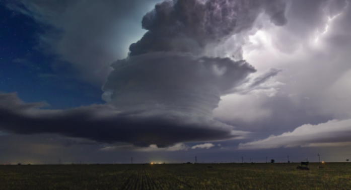
With dew points climbing into the upper 60s and 70s meeting intense upper-level winds, the FOX Forecast Center warns that the ceiling for storm intensity today is significantly higher than what we’ve seen in recent days.
For major population centers like St. Louis and Springfield, this translates to a window where the threat for EF-3 or stronger tornadoes is at its highest frequency for the entire month.
A dire flash flooding situation is unfolding across the Kansas City metro this morning, with local law enforcement reporting multiple ongoing water rescues as torrential rains overwhelm urban drainage systems.
The National Weather Service has issued a Flash Flood Warning for the entire city after 1 to 3 inches of rain fell in a short window.
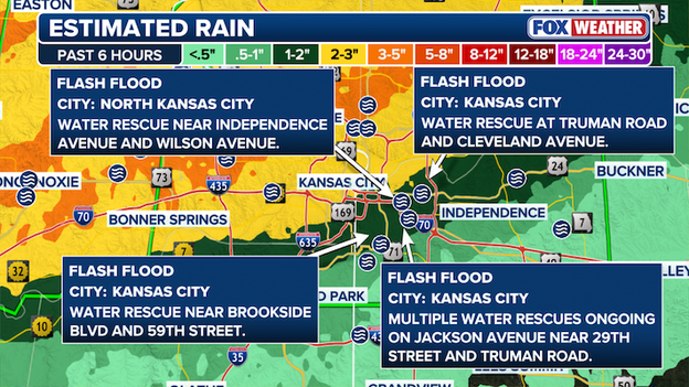
Multiple water rescues have been reported near the Kansas City metro area this morning as torrential rain inundated roads.
The morning commute has been paralyzed by the rising waters, particularly along Interstate 70 near Prospect Avenue, where stranded vehicles have caused massive traffic backups into downtown.
Several roads are currently closed, and officials are urging residents to "turn around, don't drown," as emergency crews work to reach those caught in the rapidly rising floodwaters.
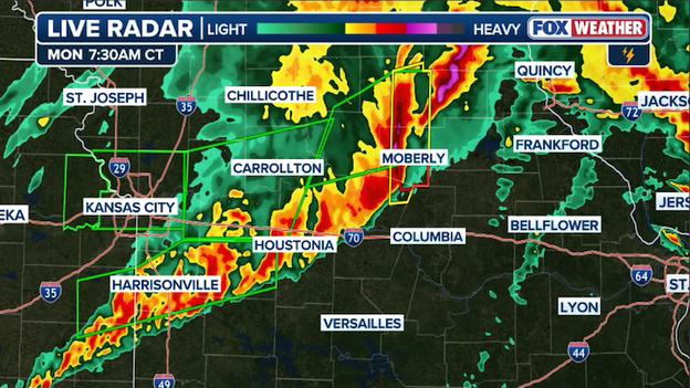
Radar image showing a line of severe thunderstorms charging east across Missouri this morning.
Intense thunderstorms are currently tearing through Missouri. These storms have already triggered Severe Thunderstorm Warnings and a few Tornado Warnings for counties around the Kansas City metro, bringing threats of 60 mph wind gusts and quarter-sized hail.
Beyond the wind and hail, these storms are dumping torrential rain, with some areas already reporting staggering totals of 3 to 5 inches.
As the line charges eastward toward the I-70 corridor, the primary concern remains its ability to produce embedded tornadoes and significant flash flooding through the morning hours.
A volatile weather setup is unfolding across the Midwest and Mississippi Valley today, as the FOX Forecast Center warns of a potential severe storm outbreak.
The day's progression is currently being dictated by two early storm clusters: a weakening group in eastern Missouri and a more dangerous line that recently slammed the Kansas City metro with damaging winds and flash flooding.
These morning storms provide a significant caveat to the afternoon forecast; if cloud cover and rain linger, the atmosphere may struggle to "recharge," potentially limiting the overall severe intensity.
However, if the air mass stabilizes and clears, the region will face a highly unstable environment primed for explosive storm development.
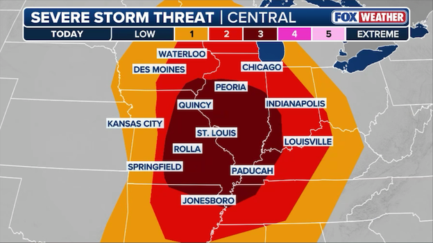
More than 60 million Americans are at risk for intense tornadoes, very large hail, and damaging winds today.
The window for the highest impact is expected between 2:00 p.m. and 10:00 p.m. ET, as a broken line of storms targets millions across at least six states.
While a Level 3 risk is currently maintained, the atmosphere remains capable of producing destructive, long-track tornadoes (EF-3 or higher) and baseball-sized hail, particularly in south-central Illinois and eastern Missouri.
Residents in cities like St. Louis, Evansville, and Springfield should prepare for damaging winds as the system congeals into a powerful line.
Because the high-threat zone has shifted slightly south, the FOX Forecast Center is monitoring potential impacts as far south as Arkansas through the late evening hours.
You’ve reached the beginning of this live coverage.