Live updates: Dangerous storms target the Plains in first potential severe storm outbreak of 2026
Live updates: Dangerous storms target the Plains in first potential severe storm outbreak of 2026
Download the AppWhat to know at this hour
View postCoverage for this event has ended.
A multi-day severe weather event is impacting the Central and Southern Plains this week.
Storms have already started tonight and will continue through Saturday morning.
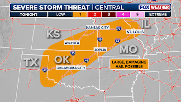
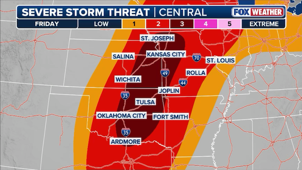
The Storm Prediction Center has issued a level 2/5 risk for Wednesday and level 3/5 risk for Friday.
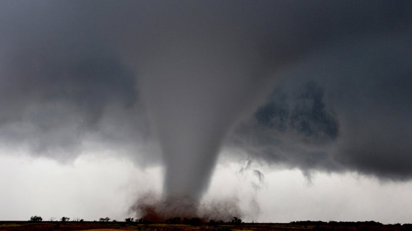
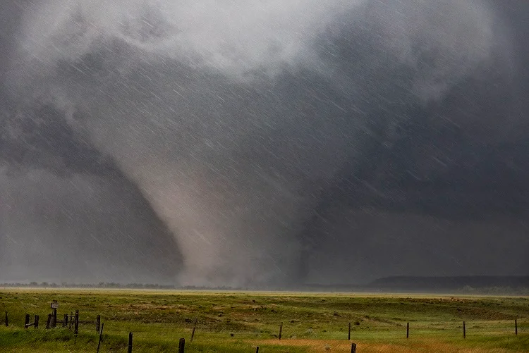
The FOX Forecast Center expects millions will be impacted by thunderstorms, damaging wind gusts, large hail and possible tornadoes.
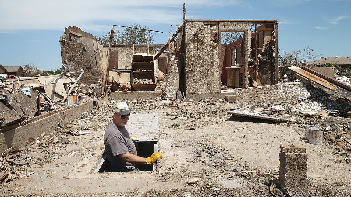
If you happen to be in a region that is in a path of a tornado, look for your local tornado shelter location here.
In an average year, about 1,000 tornadoes are reported across the U.S., resulting in 80 deaths, according to the National Weather Service.
Governor Andy Beshear posted on social media warning about potential severe weather that will impact Kentucky tomorrow.
According to the National Weather Service, thunderstorms, heavy showers, strong winds, hail and isolated tornadoes are expected in the central and south central regions of the state. Periods of very heavy rain could cause local flash flooding as well.
It is advised to be aware of the weather situation tonight and tomorrow, and have an action plan in case severe weather or flash flooding threatens your area.
Severe storm season has sprung upon the U.S. as storms begin to pop up across Oklahoma and Illinois.
The storms that will impact the region overnight will continue to pose a large hail risk.
Scattered thunderstorms will remain from Oklahoma and Texas to the mid-Mississippi Valley into Wednesday morning.
By Wednesday afternoon, thunderstorms will likely develop in central Oklahoma into southern Missouri.
A level 2/5 risk has been issued for Wednesday, with large, damaging hail and strong wind gusts being the biggest severe storm threats.
There is a conditional tornado threat associated with some of these storms as well.
The multi-day severe storm threat will continue through the end of the week.
Nearly two dozen Severe Thunderstorm Warnings have been issued in Central Illinois tonight, with no signs of slowing down throughout the week.
The ongoing severe weather threat is for Central, East Central, Southeast and West Central Illinois.
Popular locations such as Macon, St. Clair and Moultrie counties are at risk of widespread rainfall and localized small hail, as well as flooding.
Thunderstorms will remain over rural areas in the counties listed above.
Severe weather that is expected to affect the South
As severe weather begins to move into the South, a large hail threat is forming.
According to the Storm Prediction Center, a level 1/5 risk was issued on Tuesday with large hail posing the biggest risk.
A level 2/5 risk has been issued for Wednesday, with large, damaging hail and strong wind gusts being the biggest severe storm threats.
Severe weather is expected through Friday.
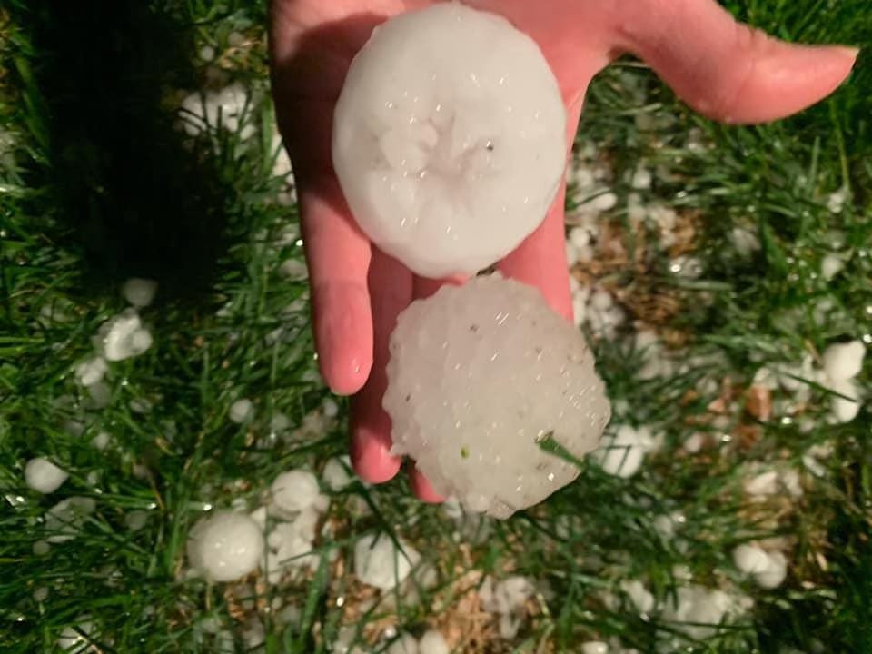
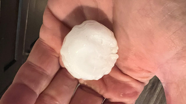
Hailstorms can be potentially harmful since it can result in dents on cars, damage to roofs, break windows and in some cases cause causalities, according to the National Weather Service.
Severe weather warnings are starting to appear in the Midwest.
The National Weather Service (NWS) in Lincoln, Illinois, has issued 23 Severe Thunderstorm Warnings so far this evening for the state.
NWS officials expect periods of showers and a few thunderstorms to bring widespread rainfall through tonight with a low flooding risk.
Stronger storms could generate quarter-sized hail in various areas, with damage to vehicles expected.
In addition, there is a level 1/5 risk of severe thunderstorms south of I-70 through Wednesday evening, with the main threat being hail.
To make matters riskier for locals in the state, all of these Severe Thunderstorm Warnings are not even in the SPC's Marginal Risk area, according to the FOX Forecast Center.
They say in the weather world that "if you don't like the forecast, wait five minutes." But if you’ve been waiting for a Severe Thunderstorm Watch this winter, you’ve been waiting over three months.
As of early March 2026, we are looking at a truly bizarre statistical anomaly. While the first two months of the year have seen their fair share of turbulence—including 10 Tornado Watches—the number of Severe Thunderstorm Watches remains a staggering zero.
This isn't just a quiet season; it’s a record-breaking one. Since 2006, there has consistently been at least one Severe Thunderstorm Watch issued during the winter months (December, January, or February) across the Continental U.S.
The last time the Storm Prediction Center (SPC) pushed the button on a severe thunderstorm-specific watch was November 23, 2025. That means we’ve gone over 100 days without a dedicated 'wind and hail' watch.
In the hierarchy of weather alerts, a Tornado Watch is the big brother. Because a Tornado Watch technically covers all the hazards of a Severe Thunderstorm Watch (damaging winds and large hail) plus the added threat of rotation, the SPC doesn't need to issue both.
In early 2026, the setups we’ve seen have been all or nothing. The dynamics have favored high-shear environments where the tornado threat was prominent enough to skip the lower-tier watch entirely.
It serves as a great reminder of how unique every season can be. We’ve managed to bypass the most common summer watch type for an entire winter—a streak that likely won't last long as we head into the volatile spring transition.
Severe storms are expected to erupt across the Central U.S. through the week as severe weather season kicks off.
- Timing: March is kicking off with the threat for severe weather across the Central U.S. Severe storms will be possible each afternoon/evening in the region, but forecasters are targeting Friday for the worst storms.
- Locations: Storms are expected from Wisconsin to Kansas to Texas this week, with the potential for tornadoes focused across Oklahoma, Kansas, Texas, and Missouri.
- Primary Impacts: Large, damaging hail (larger than quarters), destructive winds over 70 mph, and tornadoes will all be possible.
- Flood threat: Heavy rain may lead to flash flooding—which is when a sudden, violent flood happens shortly after intense rain—especially in areas from Missouri to Ohio.
- Second-screen experience: We are integrating our live stream directly with this blog to provide you with a seamless way to watch live coverage while tracking the latest text updates.
While a strong, established La Niña is a well-known driver of severe weather, some of the most prolific tornado outbreaks in history have occurred when the pattern was actually in its death throes.
As we look at the current transition in April 2026, understanding the mechanics of a fading La Niña is key to predicting spring volatility in the Plains.
The phenomenon is often referred to by meteorologists as a "Positive Trans-Niño" event. This occurs when sea surface temperatures in the central Pacific remain cooler than average while temperatures near the South American coast begin to warm up. This specific temperature gradient creates a perfect storm of atmospheric conditions over North America.
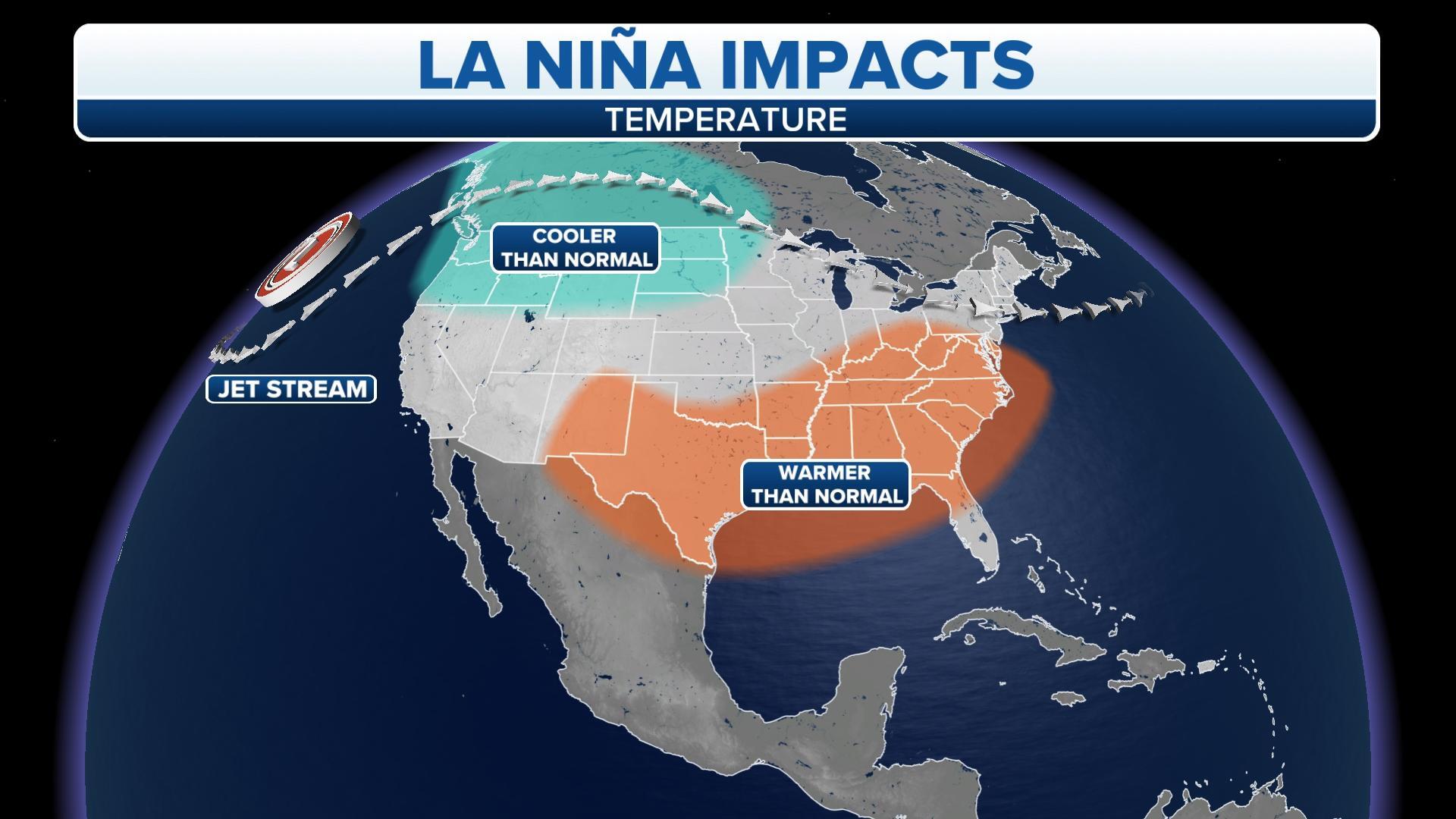
In a full-strength La Niña, the jet stream is often pushed far to the north. However, as La Niña weakens, the jet stream becomes more erratic and highly energized. It tends to dip farther south into the Southwest U.S. more frequently. This troughing in the West acts as an engine, ejecting powerful disturbances into the Plains that provide the lift necessary for supercell development.
A transitioning La Niña often strengthens the Low-Level Jet (LLJ)—a fast-moving ribbon of air just above the Earth's surface. As the upper-level jet dips south and the LLJ surges north from the Gulf, it creates intense vertical wind shear (the change in wind speed and direction with height). This is the essential twisting force that allows thunderstorms to rotate and produce tornadoes.
Because a dying La Niña often features a persistent high-pressure ridge over the Southeast or the Gulf of America, it keeps the feed of abundant moisture wide open. This allows high-dew point, tropical air to surge deep into Kansas and Oklahoma. When this unstable air mass meets the sharp drylines and cold fronts typical of April, the results are often explosive.
History proves that the transition phase is often more dangerous for the Southern and Central Plains than the peak of the cycle:
- April 1974 (1974 Super Outbreak): Occurred during a dying La Niña.
- April 2011 (2011 Super Outbreak): Though often called a La Niña year, the event took place as the cold anomalies were rapidly fading, creating a high-contrast environment.
- Recent research: Studies show that a La Niña transitioning toward neutral or El Niño boosts the likelihood of tornado outbreaks in Kansas and Oklahoma by up to 50% in the month of April.
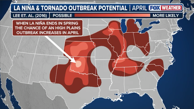
Research shows the chances of a tornado outbreak increase across the Plains states during years with a dying La Niña during spring.
While there's no way to definitively forecast severe weather outbreaks weeks or months in advance, FOX Weather meteorologists are closely monitoring the threat for severe weather across the Central U.S. as La Niña fades this spring.
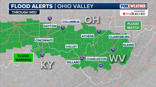
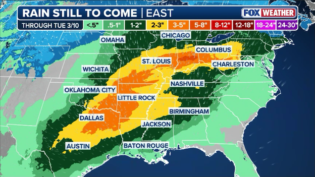
Flood Watches are now in effect for parts of Ohio, Indiana, and West Virginia.
The National Weather Service has issued Flood Watches for significant portions of the Ohio Valley, effective through Wednesday afternoon.
As a stationary front remains draped across the region, a plume of rich moisture is fueling rounds of heavy rain and thunderstorms.
Areas along and south of the I-70 corridor, including the Miami Valley and southern Ohio, are in the primary path of this slow-moving system.
The FOX Forecast Center is expecting widespread rain totals of 2 to 3 inches, with localized amounts potentially climbing higher where thunderstorms "train" or repeat over the same communities.
This heavy deluge is likely to cause rapid rises in rivers, creeks, and streams, while also creating dangerous ponding on roadways and in low-lying urban areas.
Because much of this rain is expected to fall tonight and during the Wednesday morning commute, visibility will be reduced and travel may be hazardous.
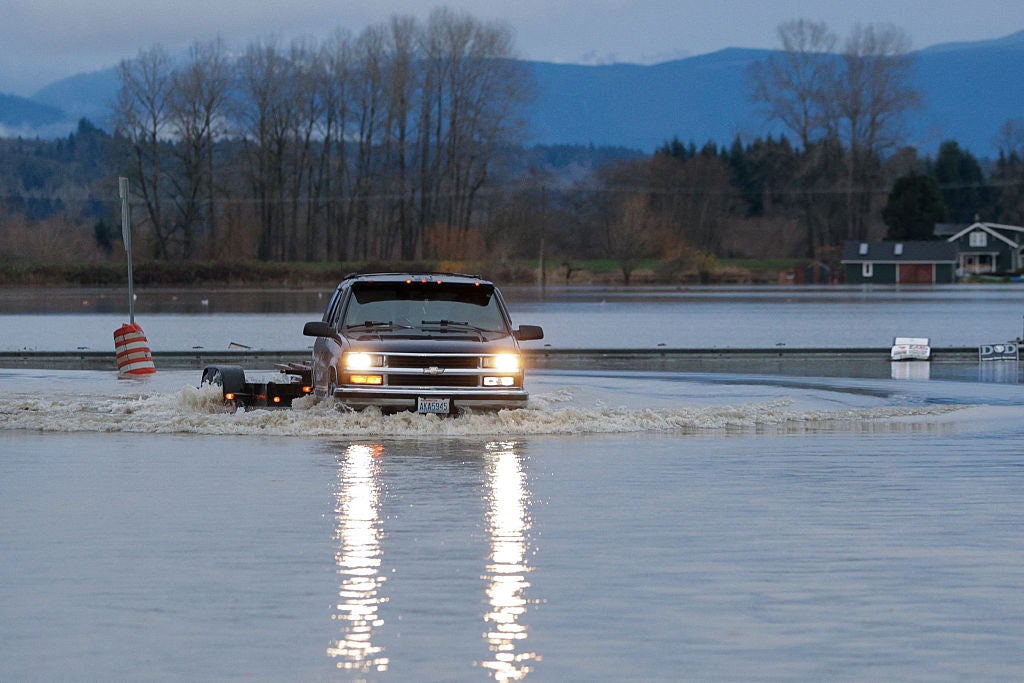
While much of the attention this week has focused on the threat of severe wind and tornadoes, a parallel danger is quietly building: significant flash flooding.
As we move through the rest of this week and into the weekend, a series of slow-moving storm rounds is expected to dump several inches of rain on already saturated ground across the Heartland, particularly from Oklahoma and Kansas into the Missouri Valley.
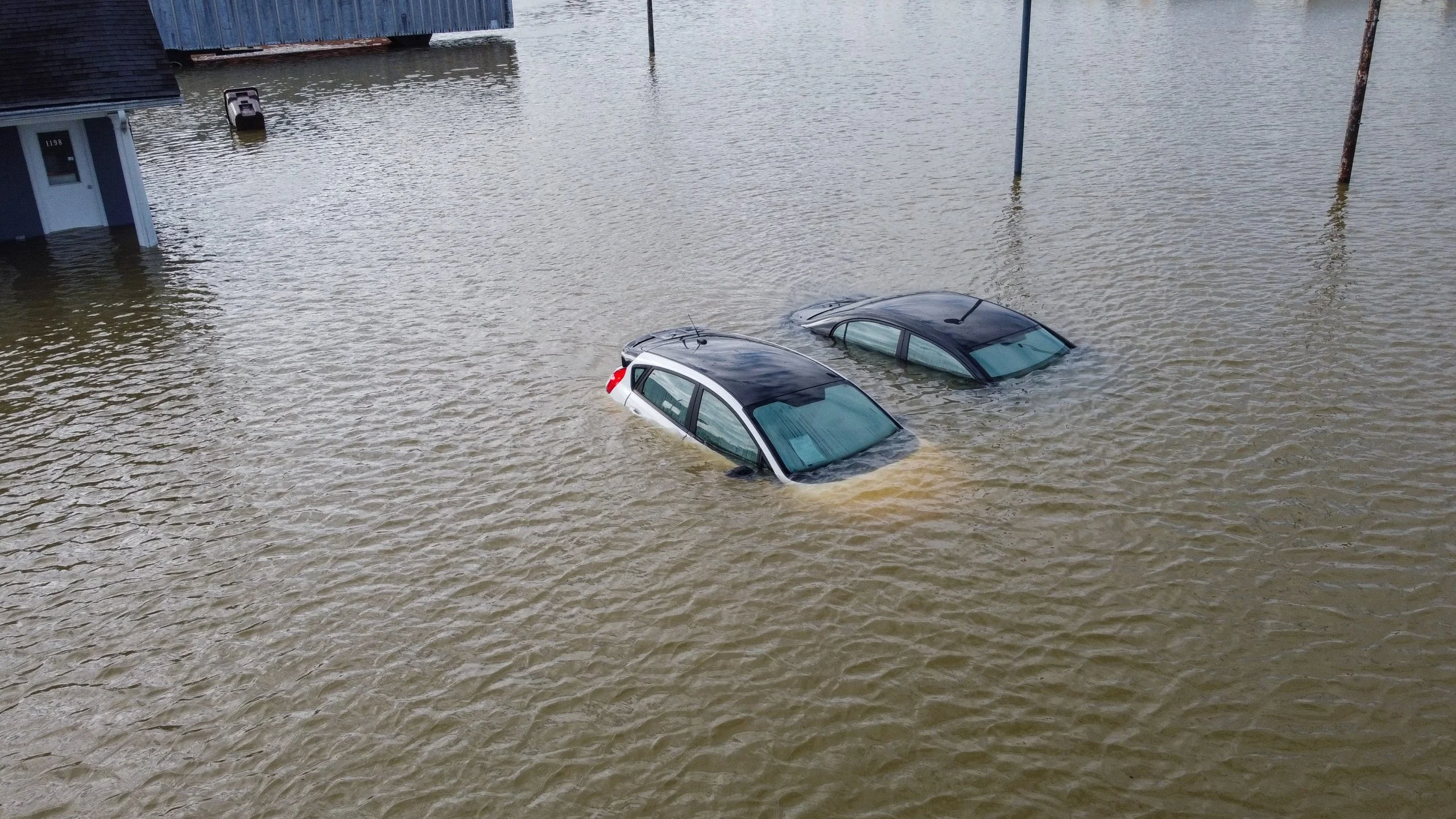
The setup is a classic spring "flood trap." An upper-level trough is stalling over the western U.S., pumping a continuous stream of deep moisture from the Gulf directly into the central states.
Because these individual storm cells are expected to track over the same areas repeatedly—a process meteorologists call training—rain totals could quickly climb to 5 to 8 inches in localized spots by Sunday evening.
Significant rain is predicted to fall across America's Heartland over the next few days.
And with storms firing repeatedly after dark, the risk of unknowingly driving into a flooded roadway increases significantly.
The National Weather Service is reminding everyone in the risk areas to stay vigilant.
Remember the golden rule of flood safety: Turn Around, Don't Drown. Most flood-related fatalities occur in vehicles, and it only takes 12 inches of rushing water to carry away a small car.
Thunderstorms are expected to pop across Oklahoma and South-Central Kansas late tonight as a cold front collides with moisture surging from the Gulf.
Future Radar indicates that the atmospheric cap will likely break after 9:00 p.m. local time, leading to scattered thunderstorms that will track eastward along the I-44 corridor through the pre-dawn hours.
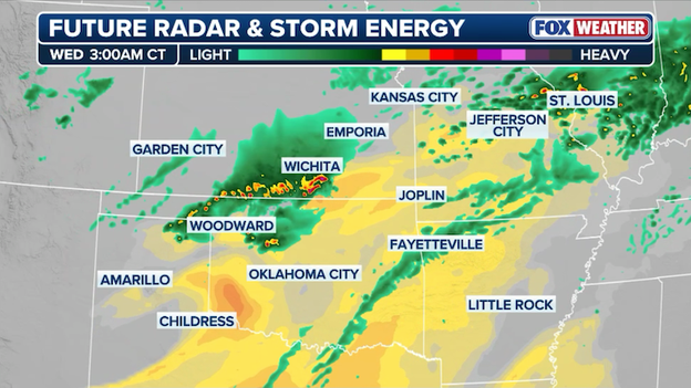
Future radar showing storms popping up across Oklahoma and Kansas overnight.
While these overnight blooms are the opening act for a multi-day severe weather setup, they bring immediate risks of frequent lightning and quarter-size hail that could easily wake you up.
Because these storms are firing up while most people are asleep, it is critical to ensure your FOX Weather App alerts are enabled on your phone before dozing off.
This overnight activity serves as a precursor to more significant severe weather risks forecasted for Wednesday through Friday.
Stay weather-aware, as tonight’s development will set the stage for the intensity of the storms to follow later this week.
The Storm Prediction Center (SPC) has officially issued its first revamped outlook, marking a major milestone in how we communicate the risk of dangerous storms to the public. For over a decade, the "Marginal to High" risk scale has been the gold standard for severe weather preparedness. But today, marks the most significant evolution in SPC history since 2014.
The SPC has officially issued its first revamped 'Convective Outlook,' introducing Conditional Intensity Groups (CIGs).
If you’ve looked at the maps today and noticed new hatching patterns or extra numbers, don't worry—the system hasn't become more dangerous, it’s just become much more precise.
The biggest takeaway is that the 1-to-5 Categorical Risk scale is NOT changing. You will still see Level 1, 2, 3, 4, and 5 risks from FOX Weather. These still represent the probability and coverage of severe weather.
The revamp lives within the individual hazard maps (Tornado, Wind, and Hail). The old, single 'hatched area' for significant threats has been replaced by three distinct tiers of intensity:
Tornado Intensity Tiers
- CIG 1: Potential for strong tornadoes (EF-2).
- CIG 2: Potential for violent tornadoes (EF-3).
- CIG 3: Violent tornadoes, reserved for the most extreme, historic setups (think April 27, 2011).
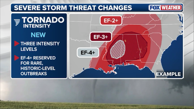
New tornado threat maps debut today on FOX Weather, showing where powerful tornadoes are most likely.
Damaging Wind Tiers
The wind outlook now features CIGs 1 through 3 to differentiate between standard 60 mph gusts and high-end derecho events. Additionally, new 75% and 90% probability thresholds have been added to highlight high-confidence, widespread wind damage events.
Large Hail Tiers
CIG 1: Potential for "Very Large" hail (2" to 3.5") & CIG 2: Potential for "Giant" hail (over 3.5", or softball-sized)
As we track the potential for dangerous storms this week, you’ll likely hear our meteorologists use the term "severe weather outbreak." But what does that actually mean for you?
In the world of weather news, an outbreak isn't just a single storm; it’s a high-impact event where a specific set of atmospheric ingredients triggers a series of severe storms over a large area.
A severe weather outbreak occurs when a single weather system produces a continuous and widespread rash of severe weather reports—such as tornadoes, damaging winds, or large hail—typically over the course of a day or more.
For you, this means the threat isn't isolated to one town or county; it’s a regional event that requires live, continuous coverage to keep everyone informed in real-time.
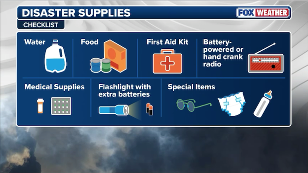
Having a safety kit ahead of time can ensure you're prepared when severe weather strikes.
Severe weather outbreaks can be overwhelming with dozens of storm reports pouring in each hour as storms hammer America's cities and towns.
During an outbreak, the sheer volume of "what is happening right now" can be overwhelming. That is why FOX Weather will provide live updates—to give you a single source of truth that combines breaking news, expert analysis, and a seamless live stream for a second-screen experience before, during, and after the storms hit.
For now, you should prepare by downloading the FOX Weather App and enabling critical weather alerts to know when warnings are issued for your area.
Check the hour-by-hour forecast and keep an eye on the real-time interactive radar to see when storms are threatening your hometown.
And watch FOX Weather LIVE 24/7 on your favorite device to keep up with the changing forecast.
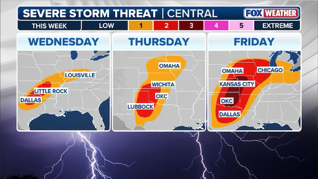
As we look toward the end of the week, our focus shifts to Friday, which currently appears to be the most impactful day of this multi-day severe weather event. The atmospheric 'ingredients' are beginning to align as a powerful storm system taps into a rich supply of moisture and energy, creating a classic clash of the seasons across the nation’s heartland.
The magnitude of Friday's threat will depend heavily on the timing and strength of a few key features.
The primary fuel for these storms is low-level moisture—which is essentially the humid air streaming north from the Gulf of America.
If this moisture returns faster or deeper than currently forecast, the potential for intense, rotating storms will increase significantly across the target zone from Texas and Oklahoma up to Chicago.
Conversely, if extensive cloud cover or early-morning rain lingers across the Plains, it could act as a blanket, keeping the ground cooler and decreasing the overall energy available for severe storms to tap into later in the day.
Another critical factor we are watching is the wind shear, or the change in wind speed and direction with height.
Stronger shear can tilt a storm, allowing it to become more organized and persist for hours, which would increase the risk for tornadoes and damaging winds.
However, if the strongest winds aloft arrive too late in the evening after the sun has set and the air has begun to cool, the cap—that lid on the atmosphere we often discuss—might hold firm, limiting the number of storms that can actually break through and become severe.
Severe thunderstorms are forecast to erupt across the nation's Heartland on Friday in a potential severe weather outbreak.
Right now, the FOX Forecast Center is focusing on western Missouri, eastern Kansas, and Oklahoma for Friday. This area is where all those ingredients could be maximized, sparking the most number of severe thunderstorms.
While severe storms will be possible as far north as Chicago, Illinois and as far south as Austin, Texas, forecasters say the most destructive storms may fire from Kansas City to Oklahoma City on Friday afternoon-evening.
If you're living in this region, now is the time to stay 'weather aware,' have a plan should severe weather strike, and know where to go in the event warnings are issued for your area.
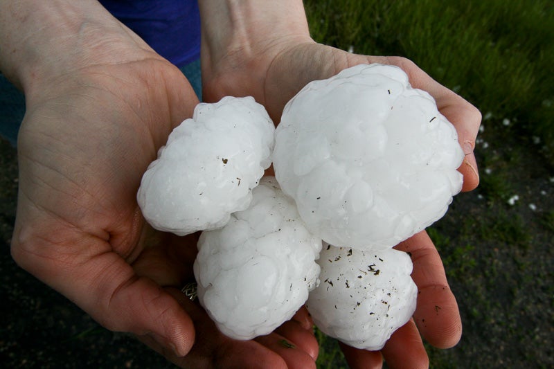
Whether it is small pea-sized pellets or massive "gorilla hail" that can destroy a car, the size of a hailstone isn't random—it's a reflection of just how powerful a storm's updraft is at that moment.
An updraft is an upward current of air that acts like an invisible hand, keeping the hailstone suspended in the freezing upper levels of a storm.
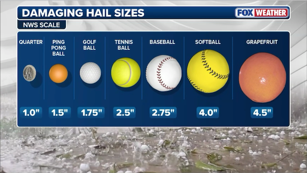
Hail size is determined by the strength of the updraft within a powerful thunderstorm.
Hail starts as tiny ice pellets. As the updraft pushes them through supercooled water droplets, layers of ice freeze onto the stone.
The stronger the updraft, the longer it can hold a heavy stone in the air, allowing it to collect more layers of ice and grow larger.
Once the hailstone becomes too heavy for the updraft to support—or the updraft itself weakens—gravity takes over and the stone falls to the ground.
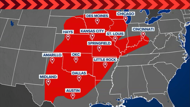
We are tracking a multi-day severe weather threat as a powerful storm system marches across the country this week. From the Southern Plains to the Great Lakes, millions of people need to stay weather-aware as the risk for damaging winds, large hail, and tornadoes intensifies.
Where the storms are headed
Our team is monitoring three distinct waves of severe weather through the end of the week:
- Wednesday: The threat shifts into the Arklatex and Mid-Mississippi Valley. Cities like Dallas, Little Rock, and Louisville are in the bullseye for potential severe development.
- Thursday: A "reloaded" threat returns to the Plains. We are watching a corridor from Lubbock and Oklahoma City up through Wichita and Omaha for a renewed round of dangerous storms.
- Friday: This looks to be the most impactful day of the week as the system gains strength. A significant severe weather risk stretches from Dallas and OKC all the way north to Chicago, with the highest concern centered over parts of Kansas and Oklahoma.
Millions of Americans are facing the threat of severe weather this week across the Central U.S.
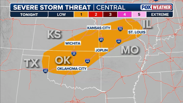
Severe thunderstorms are expected to fire up across the Central Plains later this evening and overnight.
We are keeping a close eye on the skies across the Central U.S. tonight as a multi-day severe storm threat develops.
While much of the day might seem quiet, don't let the sunshine fool you; the atmosphere is essentially "loading the spring" for storms to develop after dark.
FOX Forecast Center meteorologists are watching a stout low-level inversion over the southern and central Plains. Think of this inversion as a "cap" or a lid on the atmosphere that keeps clouds from growing too tall during the heat of the day. However, as we head into the evening, that lid is expected to weaken.
We are specifically watching the area where the dryline—a boundary separating moist air from the Gulf and dry air from the desert—meets a surface front near southwest Oklahoma. This intersection is often the spark that flies to start the fire.
A few robust storms could break through the cap near the I-44 corridor in Oklahoma later tonight. If these form, they will bring an isolated threat of large hail (larger than quarters).
These storms will spread from Oklahoma and Kansas into Missouri and western Illinois through early Wednesday morning.
You’ve reached the beginning of this live coverage.