LIVE: Excessive rain, life-threatening flash flooding in California
LIVE: Excessive rain, life-threatening flash flooding in California
Download the AppCoverage for this event has ended.
The National Weather Service reported Santa Rosa, CA (North San Francisco Bay Area) received 5.37 inches of rain so far today. Santa Rosa's previous record from 2010 was only 2.04 inches for the day. On average, Santa Rosa sees 1.71 inches of rain for the entire month.
Downtown San Francisco reported a record 2.58 inches breaking the previous 1998 record of 0.91inches. Oakland broke their 1951 record of 0.39 inches with 2.02 inches of rain today.
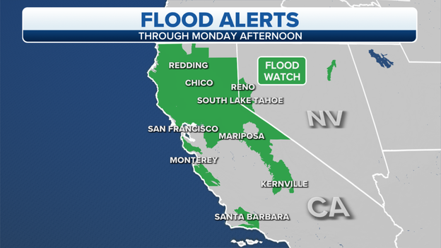
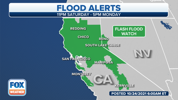
Flood Watches
Heavy rains fueled by the "Atmospheric River" will slowly push south Sunday night and Monday. Check out the active Flood Watches and Alerts below. The San Francisco Bay Area, Sacramento Valley and Sierras have seen rainfall rates of 1 inch per hour at times -- a lot of rain for an area that has barely seen measurable rain for the past seven months.
The flood threat (including flash flooding closing roads, 35 mph winds blowing trees into power poles, and landslides that block roadways) stretches to Santa Clara, Santa Cruz, and Monterey Counties overnight.
Monday the Central Coast to Los Angeles braces for up to 4 inches of rain in higher elevations and up to 1.5 inches in L.A. The Central Valley and mountains hit hard by 2020 and 2021 fires are prepping for flash flooding and landslides with up to 6 inches forecast for Yosemite.
The California Highway Patrol has been busy with water rescues like this one in Santa Rosa, CA. Heavy rain flooded this stretch of roadway between vineyards. The driver escaped, the car did not.

North San Francisco street flooding up to 3 feet in some neighborhoods.
Parts of Napa and Sonoma are seeing rainfall rates of 0.25 to 0.5 inches in one hour. Unofficial rain totals are coming in up to 5 inches in the Bay Area.
Rain has flooded major roadways everywhere from San Leandro to San Rafael to Napa. Rain has softened earth around tree roots so there have been many reports of trees down across roads and power outages as trees fall on lines. Public Gas and Electric Company alone has reported tens of thousands of businesses and residents currently without power in the Bay Area alone.
Rain slicked streets are blamed for numerous accidents like the one blocking both eastbound lanes on the Richmond San Rafael Bridge.
Santa Rosa emergency crews are now on the scene of a high water rescue. Local sandbag station supplies are dwindling as the rain continues.
The San Rafael Police Department reports that many roads in the Downtown San Rafael Corridor are under 2 feet of water and are closed and impassable.
San Rafael in the North San Francisco Bay Area is under a Flash Flood Warning until 6:15 PM PDT.
Aerial footage of Highway 70 in Plumas County. CA shows how heavy rain loosened rock and mud resulting in this huge slide blocking both directions of the highway. Caltrans says the tons of debris already on the road will take days to clear out but fear with additional heavy rains expected to continue until early Tuesday, the entire hillside could give way.
Rains falling on the Dixie Fire burn scar collect and quickly strip the land of soil and rocks with no vegetation to hold the earth in place.
The National Weather Service just extended their Flash Flood Warning for large portions of previously fire-ravaged areas of Sonoma and Napa Counties until 3:30 PM PDT. Radar indicates rainfall rates of 0.75 - 1 inch per area over the LNU Lightning Complex burn area. Calistoga, parts of St. Helena and west towards Kenwood, about 9,700 people are preparing for rock, mud, and tree slides as well as rapidly rising creeks.
As heavier rain and snow moves into the Sierras and the Foothills, the California Department of Transportation, Caltrans, asks drivers to stay off the roads. Areas in the Caldor Fire burn scar are expecting 0.6 to 1 inch of rain an hour which makes mudslides likely and traveling on freeways like Highway 50 treacherous.
Already, crews rescued drivers of overturned cars due to the slick roads. Snow levels are around 7,500 feet and falling to 5,500 to 6,500 feet Monday. Chain controls are in effect and Caltrans fears more road closures.
Forecasters estimate up to 7 inches of rain for South Lake Tahoe and other burned areas by Tuesday morning.
Evacuation orders are in place in Santa Barbara County for areas of the Alisal Fire burn scar. Half-inch rain per hour estimates have been driving debris flows. Up to 4 inches of rain are expected.
The Red Cross is manning an evacuation center.
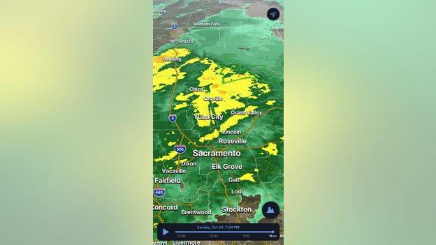
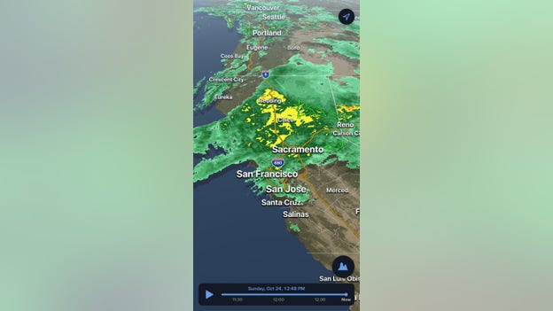
Here's what all those colors mean if you're tracking the heavy rainfall across California today.
Here's what all those colors mean if you're tracking the heavy rainfall across California today:
"What were looking at is where the radar is picking up rain across northern California," FOX Weather Meteorologist Greg Diamond said. "Light green is where light rain is falling. Dark green shows moderate rain, yellow and orange show heavy rain."
But what's about that green box?
"The green lines are where the National Weather Service has issued Flash Flood Warnings," Diamond said. "You can touch those warnings on the app to pull up the full warning text."
Heavy rain with continue in California, and you can track the storms with our 3D radar.
Head to foxweather.com to download the free FOX Weather app
Track extreme weather in the free FOX Weather app
Reports of power outages are continuing to climb in California.
So far, more than 62,000 outages have been reported.
Most outages are in Sonoma County where nearly 20K have been reported.
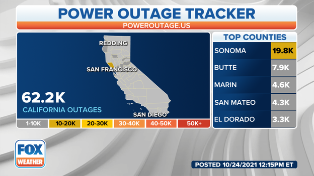
Reports of power outages are expected to climb as a powerful storm continues to impact the area.
Water can’t be absorbed in burn scars and runoff can occur quickly.
Debris can be picked up by the water with little time to take action.
Have a plan in place.
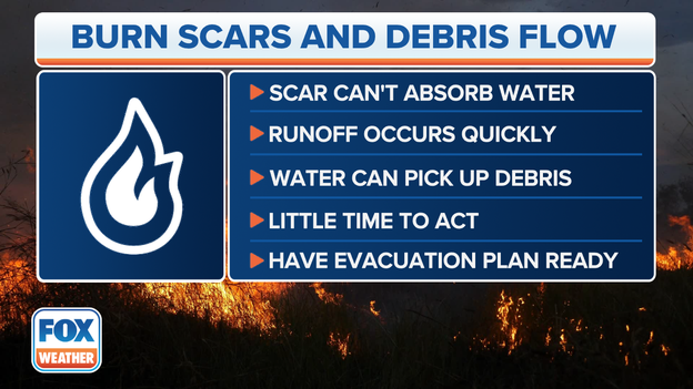
Here's why burn scars and debris flows are so dangerous.
Flash flood watches are in effect in California from the Oregon border to south of the San Francisco area.
Life-threatening flash flooding is possible across northern and central California.
There's an extreme risk of flash flooding in parts of California.
The greatest risk of life-threatening flash flooding exists in the upslope region of the Sierra Nevada mountains.

Excessive rain will increase the risk of flash flooding on Sunday.
You’ve reached the beginning of this live coverage.