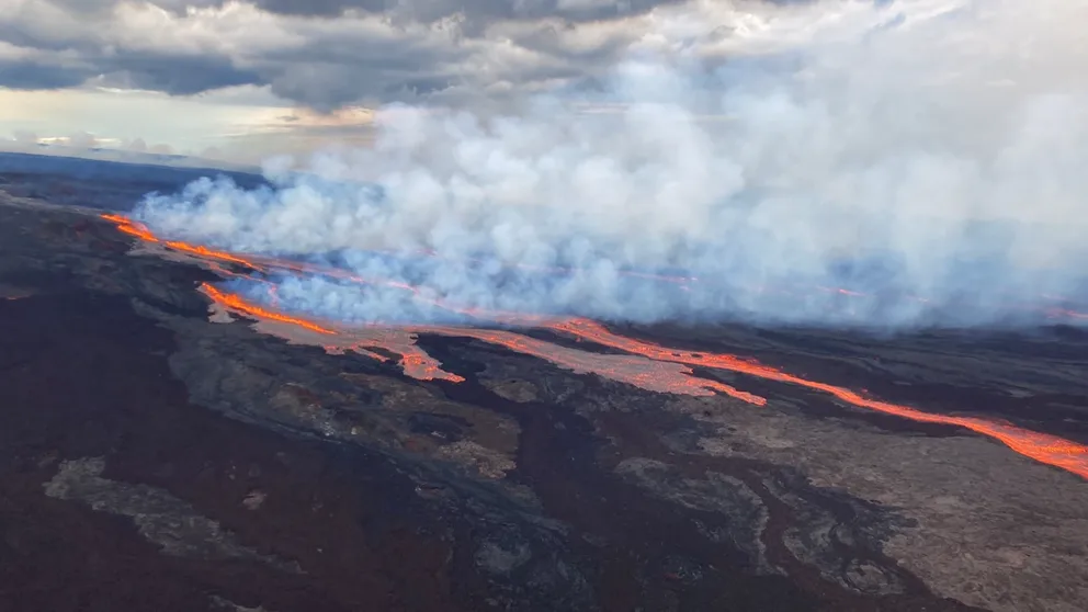
Lava flows from Mauna Loa volcano create glowing sky across Hawaii's Big Island
The world's largest active volcano began erupting Sunday night for the first time since 1984. Residents on Hawaii's Big Island are reporting the glow from lava flows can be seen around the island.
World's largest active volcano, Mauna Loa in Hawaii, erupts overnight for first time in decades
For the first time in 38 years, Hawaii’s Mauna Loa volcano began erupting on Sunday night.
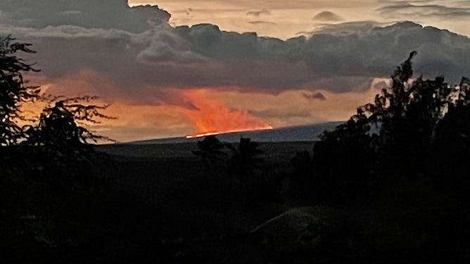
BIG ISLAND, Hawaii – Mauna Loa, the world's largest active volcano located in Hawaii Volcanoes National Park, began erupting Sunday, sending ash thousands of feet into the air and illuminating the sky with the light of glowing lava on the ground below.
The eruption ended a 38-year stretch between activity.
The volcano has not prompted evacuations yet, but shelters have opened as a precaution, and residents are being told to review emergency plans.
According to forecasters with National Weather Service in Honolulu, ash from Mauna Loa reached up to 45,000 feet, prompting Ashfall Advisories for the Big Island until Monday evening. The NWS warned that winds may carry volcanic gas, ash and volcanic glass fibers known as Pele's Hair downwind.
Mauna Loa Eruption In Hawaii
Hawaii's Mauna Loa volcano began erupting on Sunday night for the first time in 38 years, and residents have been told to start reviewing emergency plans in case lava flows threaten local communities.
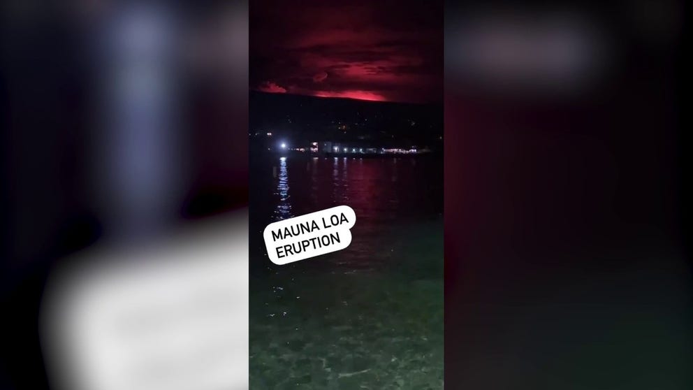
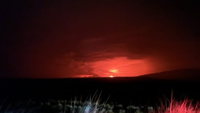
A Hawaii realtor recorded the glow of Mauna Loa erupting against the backdrop of the water on Kailua Bay pier around 2 a.m. Monday calling it "eerily beautiful."
The glow of lava cast an angry red light across the sky that could be seen for miles around as residents began their workweek with the eruption underway.
WATCH LAVA FLOW IN THESE MESMERIZING VOLCANIC ERUPTIONS AROUND THE WORLD
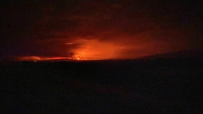
Ken Hon, the U.S. Geological Survey Hawaiian Volcano Observatory scientist in charge, photographed the ongoing eruption Monday from Waikoloa, about an hour from the Mauna Loa Observatory.
![Lava is seen flowing from Hawaii's Mauna Loa volcano after it began erupting on Sunday night.]() Image 1 of 8
Image 1 of 8Lava is seen flowing from Hawaii's Mauna Loa volcano after it began erupting on Sunday night. (USGS/Civil Air Patrol)
![Hawaii's Mauna Loa volcano began erupting on Sunday, November 27, 2022.]() Image 2 of 8
Image 2 of 8Hawaii's Mauna Loa volcano began erupting on Sunday, November 27, 2022. (USGS)
![A photo taken by Ken Hon, Scientist in Charge of HVO from Waikoloa at 1:27 a.m. HST on Monday, Nov. 28, 2022.]() Image 3 of 8
Image 3 of 8A photo taken by Ken Hon, Scientist in Charge of HVO from Waikoloa at 1:27 a.m. HST on Monday, Nov. 28, 2022. (Image: USGS) (USGS)
![Mauna Loa eruption as viewed from Waikoloa at about 1:25am local time (HST). The eruption is occurring from the summit of the volcano, though lava has overflowed the caldera.]() Image 4 of 8
Image 4 of 8Mauna Loa eruption as seen from Waikoloa at about 1:25 a.m. HST. The eruption is occurring from the summit of the volcano, though lava has overflowed the caldera. (Image: Ken Hon, Scientists in Charge of Hawaii Volcano Observatory) ( )
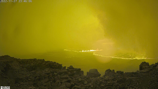
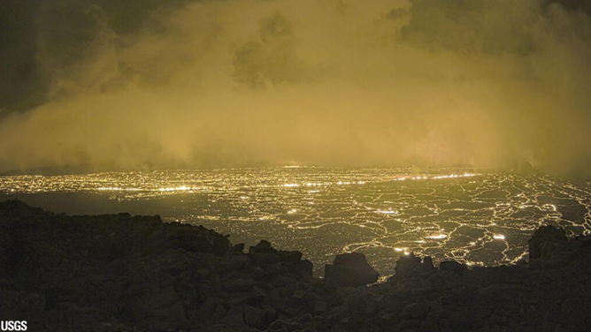
![This image is from a temporary research camera positioned on the north rim of Mokuʻāweoweo, the summit caldera of Mauna Loa volcano by the USGS Hawaiian Volcano Observatory.]() Image 5 of 8
Image 5 of 8This image is from a temporary research camera positioned on the north rim of Mokuʻāweoweo, the summit caldera of Mauna Loa volcano by the USGS Hawaiian Volcano Observatory. (Image: U.S. Geological Survey) (USGS)
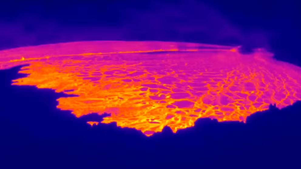
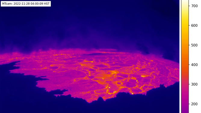
![This image is from a temporary thermal camera located on the north rim of Mauna Loa's summit caldera on Hawaii's Big Island. The temperature scale is in degrees Celsius up to a maximum of 500 degrees (932 degrees Fahrenheit) for this camera model, and scales automatically based on the maximum and minimum temperatures on the caldera floor and not the whole frame, which sometimes results in the rim (bottom of image) looking saturated (white).]() Image 6 of 8
Image 6 of 8This image is from a temporary thermal camera located on the north rim of Mauna Loa's summit caldera on Hawaii's Big Island. The temperature scale is in degrees Celsius up to a maximum of 500 degrees (932 degrees Fahrenheit) for this camera model, and scales automatically based on the maximum and minimum temperatures on the caldera floor and not the whole frame, which sometimes results in the rim (bottom of image) looking saturated (white). (Image: U.S. Geological Survey) (USGS)
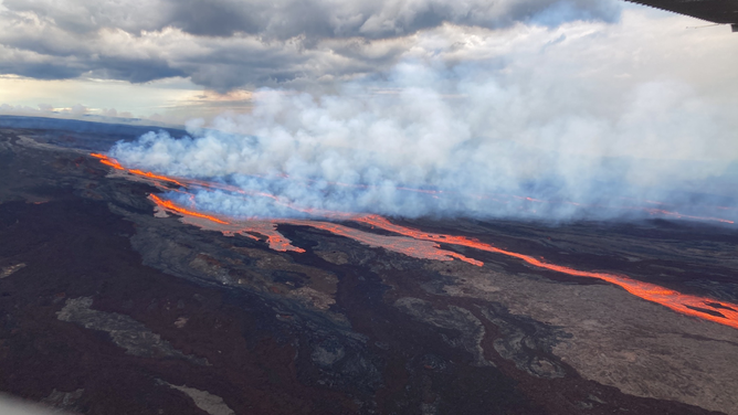
![A photo view of the Mauna Loa eruption taken from Waikoloa at 6:15 a.m. HST on Nov. 28, 2022.]() Image 7 of 8
Image 7 of 8A photo view of the Mauna Loa eruption taken from Waikoloa at 6:15 a.m. HST on Nov. 28, 2022. (Image: USGS Volcanoes) (USGS)
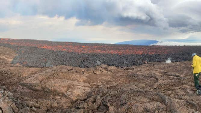
![USGS Hawaiian Volcano Observatory field crews at Mauna Loa's Northeast Rift Zone to make observations and collect information that will be used to create lava flow maps and inform hazard analysis.]() Image 8 of 8
Image 8 of 8USGS Hawaiian Volcano Observatory field crews at Mauna Loa's Northeast Rift Zone to make observations and collect information that will be used to create lava flow maps and inform hazard analysis. According to the USGS, lava flows are not threatening downslope communities. (Image: USGS) (USGS)
The USGS Hawaiian Volcano Observatory has a series of cameras located around the volcano, capturing different angles as the eruption is underway.
The images below were captured with a thermal camera from the northwest rim of Mokuʻāweoweo, the summit caldera of the Mauna Loa volcano. According to the USGS, the thermal camera temperatures show up to 932 degrees Fahrenheit, with bright yellow being the hottest temperature.
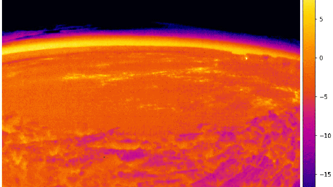
A series of images from a temporary thermal camera located on the north rim of Mauna Loa's summit caldera. The temperature scale is in degrees Celsius up to a maximum of 500 degrees (932 degrees Fahrenheit). (Image: USGS)
A different USGS camera from the north rim captures steam being emitted from the summit caldera.
Views from the USGS Volcano Observatory camera positioned on the north rim of Mokuʻāweoweo, the summit caldera of Mauna Loa volcano. (Image: USGS Hawaiian Volcano Observatory)
The magmatic activity is also visible to weather satellites in space.
The National Oceanic Atmospheric Administration's GOES-West satellite captured heat signatures from Mauna Loa's summit caldera around the time the eruption began Sunday night.
Hawaii emergency officials continue to work with the USGS to monitor Mauna Loa and determine when or if evacuations may be needed.
Jon Jelsema, senior forecaster for the NWS in Honolulu, told FOX Weather the main concern is if the lava flow fills up the caldera on top of the volcano.
"This lava is quick-moving lava that can reach the coastline in two hours. So, you can imagine how dangerous a situation that is for the communities that are downslope," Jelsema said.
Mauna Loa has averaged eruptions every five years since 1843. This marked the longest eruption-free stretch, with the last one happening in 1984. Mauna Loa began showing increased seismic activity in September.
Mauna Loa eruption: What's next for the world's largest volcano in Hawaii
The November 27 eruption is the first since 1984 for Mauna Loa—ending its longest quiet period on record.