'Bumps on a map' lead scientists to hidden 1.5-mile-tall mountain below ocean surface
Over the past eight years, the Schmidt Ocean Institute has mapped almost 580,000 square miles of the ocean floor, uncovering 29 seamounts, hills, and trenches as part of their mission to explore the mysteries of Earth's last uncharted territory.

FILE – 'Yellow Brick Road' found in ocean off Hawaii may be 100 million years old
Ocean Exploration Trust chief scientist Dr. Daniel Wagner explains the remarkable rock formation discovery in the Papahānaumokuākea Marine National Monument.
VALPARAISO, Chile – A team of scientists has discovered four massive underwater mountains off the west coast of Central and South America, which offer new insights into the mysterious world of the deep sea.
The Schmidt Ocean Institute said the tallest of these underwater peaks stands at an impressive height of over 1.5 miles, towering over the surrounding seafloor.

The largest of the four seamounts recently discovered by Schmidt Ocean Institute experts is 2,681 meters tall, covers 450 square kilometers, and sits 1,150 meters below the surface.
(Schmidt Ocean Institute)
A crew on the institute's research vessel ‘Falkor (too)’ discovered new seamounts, which range in size from about 5,220 feet to 8,796 feet, during a January journey from Costa Rica to Chile. Their discovery adds to the crew's previous discovery of an underwater mountain in international waters off Guatemala, which was made last November.
"We were fortunate enough to be able to plan an opportunistic mapping route using these gravity anomalies in satellite altimetry data," Falkor marine technician John Fulmer said. "Examining gravity anomalies is a fancy way of saying we looked for bumps on a map, and when we did, we located these very large seamounts while staying on schedule for our first science expedition in Chile at the start of this year."
MARVEL AT NEVER-BEFORE-SEEN OCTOPUS NURSERY FOUND OFF COAST OF COSTA RICA
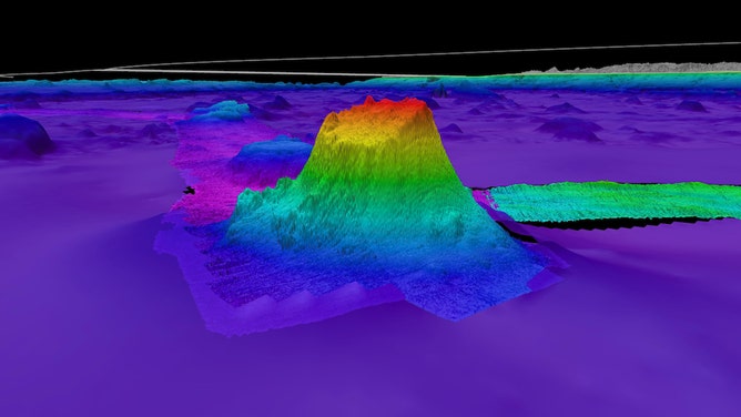
![The first of four seamounts discovered by experts on board Schmidt Ocean Institute’s R/V Falkor during an opportunistic mapping transit from Costa Rica to Chile is 1,591 meters in height and covers 177 square kilometers.]() Image 1 of 3
Image 1 of 3The first of four seamounts discovered by experts on board Schmidt Ocean Institute’s R/V Falkor during an opportunistic mapping transit from Costa Rica to Chile is 1,591 meters in height and covers 177 square kilometers. (Schmidt Ocean Institute)
![The second of four seamounts recently discovered by the team on Schmidt Ocean Institute’s R/V Falkor while traveling from Costa Rica to Chile stands 1,873 meters in height.]() Image 2 of 3
Image 2 of 3The second of four seamounts recently discovered by the team on Schmidt Ocean Institute’s R/V Falkor while traveling from Costa Rica to Chile stands 1,873 meters in height. (Schmidt Ocean Institute)
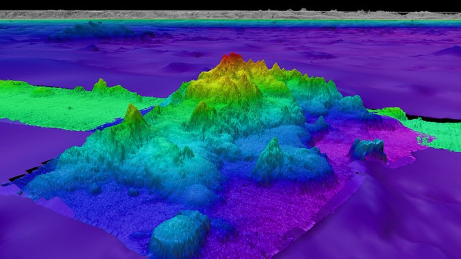
![The third of four seamounts discovered by mapping experts on board R/V Falkor is 1,644 meters in height.]() Image 3 of 3
Image 3 of 3The third of four seamounts discovered by mapping experts on board R/V Falkor is 1,644 meters in height. (Schmidt Ocean Institute)

While traveling to investigate gravity anomalies, researchers said they utilized multibeam mapping to help discover the seamounts on the seafloor, which were not previously included in any bathymetric database.
The seafloor's shape can change over time, affecting the ocean's surface, according to Schmidt Ocean Institute. For example, a deep trench can cause a small dip in the water, while a mountain can create a slight bump. Experts use these clues to discover important information and create better seafloor maps.
Since 2012, scientists on Falkor and Falkor (too) have mapped nearly 580,000 square miles and discovered 29 seamounts, hills and trenches.
Deep-sea coral reefs, sponges, and anemones thrive in underwater mountains and trenches. These organisms find food, shelter, and a rocky surface to cling to along mountain slopes.
WATCH: SEA CUCUMBER CAUGHT IN RARELY SEEN DANCE ON UNDERWATER CAMERA
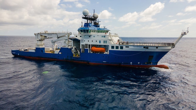
Research vessel Falkor is photographed during an expedition testing new high-resolution mapping methods. Seafloor mapping is integral to oceanographic research.
(Schmidt Ocean Institute)
"A map is a fundamental tool for understanding our planet — locating seamounts almost always leads us to understudied biodiversity hotspots," said Jyotika Virmani, executive director of Schmidt Ocean Institute. "Every time we find these bustling seafloor communities, we make incredible new discoveries and advance our knowledge of life on Earth."
Schmidt Ocean Institute is a partner of The Nippon Foundation-GEBCO Seabed 2030 Project, which aims to map the entire seafloor by 2030.
With 75% of the ocean still to be mapped, there is still a lot to be uncovered, according to Seabed 2030 Project Director Jamie McMichael-Phillips.
"These incredible discoveries by Schmidt Ocean Institute underscore the importance of a complete map of the seabed in our quest for understanding Earth’s final frontier," he said. "Ocean mapping is crucial to our understanding of the planet and, in turn, our ability to ensure its protection and sustainable management."