NASA satellites provide Earth's 'family photo album' of changing landscapes
The Landsat spacecraft fleet offers a nearly 50-year comprehensive look at our changing globe.
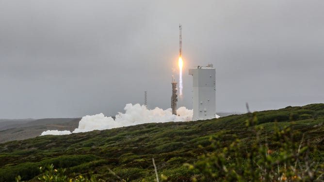
A United Launch Alliance Atlas V rocket carrying the Landsat 9 mission for NASA lifts off from Space Launch Complex-3 on Sept. 27. The new satellite will document Earth's changing landscapes and waterways. Photo Credit: United Launch Alliance
(United Launch Alliance)
A newly launched satellite will continue a NASA and U.S. Geological Survey program offering the best big-picture look of Earth's evolving farmlands, waterways and forests.
NASA's Landsat 9 spacecraft launched Monday from Vandenberg Air Force Base in California on a United Launch Alliance Atlas V rocket. After about 100 days in orbit, the satellite will become operational, offering views of Earth using its imagining instruments. The U.S. Geological Survey will operate the mission from there, sharing the data with the public.
The Landsat spacecraft constellation offers a nearly 50-year comprehensive look at our changing globe. The first mission launched in 1972.
"I compare it to like the family photo album of the planet, you don't realize changes occurring into your leaf back a few pages and you suddenly see how dramatic it's been," said Dr. Jeff Masek, the mission project scientist with NASA Goddard Space Flight Center.
The spacecraft uses two instruments to image the Earth in different wavelengths and collects surface temperature. The Operational Land Imager-2 observes the reflected light from the sun coming off Earth. The long-wave infrared imager, called the Thermal Infrared Sensor, can monitor surface temperatures on the planet.
The Landsat team is looking at the ecological effects of climate change. In the program's history, they've seen increases in vegetation in high-altitude areas where temperatures wouldn't usually allow for growth. Masek said they also see an increase in the frequency of drought.
According to Masek, the program's primary purpose is to use the data to meet societal needs, such as improving irrigation and changing planting patterns that could improve food security.
"Given that we're in a warming world. We're going to expect to see management changes to kind of cope with that in agriculture, so keeping track of things like irrigation, what areas are becoming water-limited, changes in cropping and planting patterns, those are all things that we can get out of the Landsat mission," Masek said.
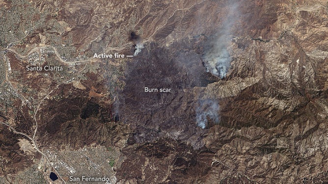
An image taken by NASA's Landsat 8 spacecraft shows scorch marks from the Sand Fire in Southern California on July 24, 2016.
(USGS, NASA)
The spacecraft data can be used to help manage agricultural lands in the short and long term, from what's growing in what field his month and how is it growing, to what areas are being affected by drought, Masek explained.
"But they also can also be used to address the longer-term land-use history question," he said. "So what areas are being planted more frequently than they used to be, what areas are no longer suitable for agriculture, either because of climate change or because of, you know, other land uses are more valuable."
Among the most dramatic changes Masek said his team is seeing in the U.S. is the decline in tropical forests and the replacement of forests for agricultural lands. Around the globe, the reduction in sea ice is well documented throughout the program's history.
But the "canary in the coal mine" for our changing planet, Masek said, is the fast vegetation growing at high latitudes.
"High latitudes are experiencing the warming faster than other parts of the planet. And sure enough, we're seeing increased grass shrub and even tree cover in the boreal and high latitude regions of North America and Eurasia," Masek said. "And that came out from satellite records, including Landsat."
This new spacecraft will be replacing the Landsat 7 satellite and work in tandem with Landsat 8. The latest edition becomes operational in early January, meaning an increase in available data for climate scientists.
"Now for the first time we have two state of the art observatories up at the same time that are getting really good quality data and allowing global land coverage every eight days, so you know it's basically a substantial upgrade from the current constellation of Landsat 7," Masek said.
The U.S. government widely uses Landsat data across NASA, the U.S. Department of Agriculture, Forest Service, USGS and the Environmental Protection Agency, and the greater scientific community worldwide. The data collected by Landsat is available for free.
According to NASA, the fleet of satellites has collected more than 9 million scenes and provided data for more than 18,000 research papers in the program's history.
There are plans for another Landsat spacecraft that will continue helping to manage our available resources best, something Masek said everyone should care about.
"You can't manage what you haven't measured," Masek said, adding the Landsat archive provides a concrete snapshot in terms of land use.
"Hopefully, that leads to better land management, whether it's agriculture and food security preservation of forests, improving water quality (and) urban planning."