Where you are likely to see the April total eclipse based on cloud cover forecasts
Based on the historical cloud data, the South and Central U.S. are more likely to have a clear sky for the April 8 total solar eclipse.
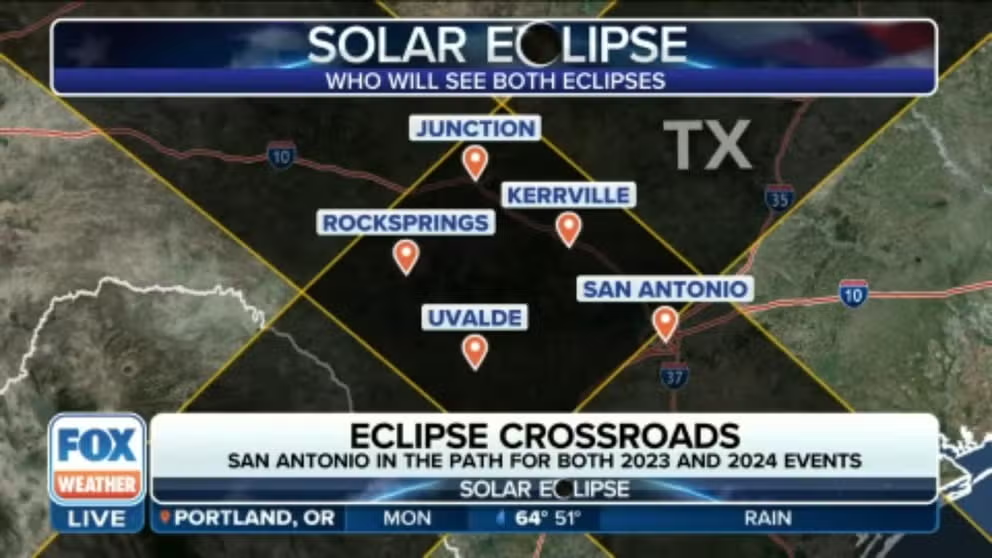
San Antonio in crossroads for total solar eclipse in April
After experiencing the "ring of fire" from the October annular solar eclipse, San Antonio will be in the crossroads for a total solar eclipse in April. Planetarium Coordinator Michelle Risse with the Scobee Education Center at San Antonio College explains what the planetarium has planned for the next Great American Eclipse.
A total solar eclipse will happen over a large swath of the U.S. this April, but cloud cover could spoil the views for millions if the weather doesn't cooperate. That's where historical weather comes in handy to help eclipse chasers find the best location to view totality – when the Moon eclipses the Sun's face.
NOAA's National Centers for Environmental Information (NCEI) released its interactive cloudiness map for the total solar eclipse on April 8. The map was created using NCEI data from climate stations along the path of totality and with help from scientists at the North Carolina Institute for Climate Studies.
WHO WILL BE ABLE TO SEE THE APRIL 2024 TOTAL SOLAR ECLIPSE?
Based on NCEI's April 2024 Total Solar Eclipse map, cities including Rel Rio and Waco, Texas, and Paducah, Kentucky, will have nearly 64% viewability for the time of the maximum eclipse at 1:40 p.m. CDT.
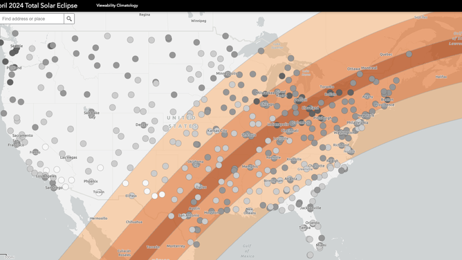
Gray dots of different darknesses represent cloud cover over the path of totality for the April 8, 2024 eclipse. (Image: NOAA)
(NOAA)
The farther north along the path of totality, the visibility starts to drop. Cleveland has nearly 39% visibility during totality at 3:15 p.m., and Buffalo, New York, has around 35% at 3:20 p.m. ET.
According to NCEI, the interactive map shows not only average cloud cover but also heat indices, temperature and more for the hours of the April 8 eclipse. These weather details are important because the eclipse is an hours-long event, and you'll need to dress for warm weather in most places and layer on sunscreen.
Even if you aren't directly along the path of totality, cities outside the path will see a partial eclipse. You need to keep your eclipse glasses on throughout a partial eclipse. Only if you are in the path of totality can you remove your glasses when the Moon briefly covers the Sun's face for several minutes.
NASA PICKS 5 EXPERIMENTS TO FUND THAT WILL STUDY 2024 TOTAL ECLIPSE IN US
The FOX Forecast Center created a cloud cover forecast based on atmospheric data from the Copernicus Climate Change Service.
The map below is based on average cloud cover data from the last 30 years for April 1-15 between 12 p.m. and 4 p.m.
You can see the cloud cover percentage go up farther north along the path of totality. Texas, Arkansas and Kentucky will be popular viewing locations for this eclipse based on historical cloud cover data.
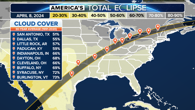
Average cloud cover for the path of totality.
(FOX Weather)
Based on the data, the south and central U.S. are more likely to have a clear sky for the April 8 total solar eclipse.
As the eclipse date gets closer, the most accurate forecasts will be available for cloud cover and weather over the path of totality. Check back on FOX Weather for the detailed forecast and add your viewing location to the events tab in the FOX Weather app.
Planning for the April 8, 2024, eclipse is your best bet to witness the astronomical phenomena unless you want to wait 20 years. The next total solar eclipse won't cover multiple states again until August 2045.