Thaw on the horizon for the Northeast following record-breaking February cold snap
Thaw on the horizon for the Northeast following record-breaking February cold snap
Download the AppNortheast says goodbye to arctic air with a massive midweek warmup
View postCoverage for this event has ended.
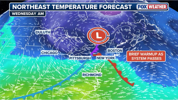
Low pressure passing through the Northeast will help warm temperatures into the 40s midweek.
After a weekend of record-shattering cold that saw wind chills plummet to -25°F in parts of the region, a major pattern shift is finally bringing relief. Temperatures across the I-95 corridor steadily climbing, reaching the freezing mark in cities like New York and Philadelphia before the big thaw kicks into high gear midweek. By Wednesday, milder air arriving will push daytime highs into the low-to-mid 40s, effectively ending the life-threatening deep freeze.
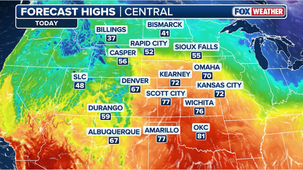
Temperatures are forecast to surge into the 70s and 80s this afternoon across the Central Plains.
While the Northeast shivers, the Central Plains are experiencing a massive mid-winter warmup today, with temperatures in parts of Kansas, Oklahoma, and Nebraska soaring into the 70s and 80s—nearly 40 degrees above seasonal averages. This warmth has triggered a critical risk of fire weather across seven states, as bone-dry air and gusty southwest winds reaching 35–40 mph create a tinderbox environment. With relative humidity plunging as low as 10%, the National Weather Service has issued widespread Fire Weather Warnings, cautioning that any spark in the dormant, freeze-cured grasses could ignite fast-moving wildfires that would be nearly impossible to contain in these conditions.

A critical Amtrak overhead wire failure near Newark triggered a chaotic and dangerous Monday morning for thousands of NJ Transit commuters. A train even became stranded in the sub-zero temperatures. NJ Transit Police and a rescue engine were deployed to Newark Liberty Airport Station to evacuate passengers who had been trapped without heat as wind chills hovered near -5°F.
While service on the Northeast Corridor and North Jersey Coast lines has officially resumed, residual delays of up to 60 minutes persist.
Following a weekend of historic, life-threatening cold that saw New York City plunge to 3°F and wind chills hit -41°F on Mount Washington, a dramatic shift in the atmospheric pattern is underway. While a clash of air masses can signal a major snow event for the Northeast, the precise timing of this week's warmup is acting as a spoiler for snow lovers.
All eyes are on a massive cross-country storm system set to arrive for the Valentine’s Day and Presidents Day weekend. However, new analysis suggests that the threat for snow is diminishing with each passing hour. The primary reason? A dramatic surge in temperatures that is expected to curtail the storm's potential to produce significant snow.
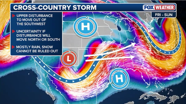
The FOX Forecast Center is tracking a cross-country storm that will deliver rain to much of the East by next weekend.
The "how" behind this weekend's lackluster snow forecast comes down to a fundamental shift in the jet stream. While the current arctic air is stubborn, it will lose its grip as a deep ridge of high pressure begins to funnel mild, Pacific air into the Ohio Valley and Northeast.
As the storm system tracks from the Rockies toward the East Coast, it will encounter an atmosphere that is already 10 to 15 degrees warmer than the current deep freeze. By Saturday morning, temperatures in major hubs like Philadelphia, New York City, and Boston are projected to climb into the upper 30s and low 40s. This means that instead of snowflakes, the system will likely deliver a steady, soaking rain to the I-95 corridor.
While the threat of a blockbuster snowstorm is fading for the coast, the weather whiplash creates a new set of risks. The transition from sub-zero wind chills to 45°F rain in less than a week creates two major concerns for the Northeast and Ohio Valley. Because the ground is currently frozen solid from the recent arctic blast, it cannot absorb water. Even moderate rain will act as immediate runoff, which could quickly fill basements and elevate the risk of flash flooding in urban areas.
And the rapid warmup combined with rain is the perfect recipe for river ice to break apart. These floating chunks can create jams near bridges and bends in the river, leading to sudden, localized flooding even in areas not directly in the heaviest rain zones.
The snow threat hasn't vanished entirely. The FOX Forecast Center says current computer model guidance depicts small sections of the Northeast will remain cold enough to keep the precipitation frozen. For everyone else, Valentine’s Day weekend is looking more like a soggy, gray thaw than a winter wonderland.
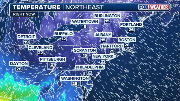
Noon temperatures are in the teens and 20s throughout much of the Northeast.
After a bitterly cold morning, the sunshine is working to warm things up across the Northeast and New England. Noon temperatures have reached into the mid 20s as they climb toward the lower 30s this afternoon.
11 a.m. wind chill temperatures are climbing as temperatures continue warming in the Northeast.
Temperatures are warming up throughout the Northeast thanks to abundant sunshine. As a result, wind chills are improving, too. By afternoon, most locations will see high temperatures near or just above the freezing mark (32°F).
Due to Amtrak overhead wire issues near Newark, NJ Transit rail service is suspended on the Northeast Corridor Line between Penn Station New York and Trenton and on the North Jersey Coast Line between Penn Station New York and Woodbridge.
According to NJ Transit's website, Raritan Valley Line trains will originate and terminate at Newark Penn Station.
NJ Transit rail tickets and passes are being cross-honored by NJ TRANSIT bus and private carriers and PATH at Newark, Hoboken and 33rd Street, NY.
Monday's deep freeze has turned the morning commute into a survival test for NJ Transit riders. Amidst sub-zero wind chills, rail service into and out of Penn Station New York is crippled by 60-minute delays caused by Amtrak overhead wire issues near Newark.
The brutal conditions turned dire for passengers on one disabled train, who required assistance from NJ Transit police and a rescue train after a downed wire cut power. With temperatures plummeting to dangerous levels, the agency has implemented cross-honoring with PATH at Newark, Hoboken, and 33rd Street to get commuters out of the cold.
Amtrak has also canceled several Keystone Service trains between New York and Philadelphia as crews struggle to restore power.
Meteorological spring begins in just 20 days, but Punxsutawney Phil, that famous groundhog prognosticator, and forecasters say spring could be delayed this year.
While the Northeast begins to thaw out from a record-breaking February deep freeze, meteorologists are sounding the alarm on a seasonal hijacking that could turn March into a winter survival sequel. The transition to spring, which typically begins in earnest by mid-March, is facing an atmospheric roadblock that threatens to lock millions in a pattern of persistent cold and coastal storms.
The primary culprit behind this volatile outlook is a disruption currently unfolding high above the Arctic. In a stable winter, the stratospheric polar vortex—a spinning ring of high-altitude winds—acts like a containment vessel, keeping the most brutal cold air trapped at the pole. However, recent data shows this vortex is stretching and splitting. When the vortex breaks down, it disrupts the jet stream below, causing it to buckle and dip far into the U.S. This creates a conveyor belt for arctic air to spill into the Northeast, often arriving two to three weeks after the initial stratospheric disturbance.
Compounding the polar vortex disruption is the -NAO (Negative North Atlantic Oscillation), more commonly known as a Greenland Block. This is a high-pressure mountain in the atmosphere near Greenland that prevents weather systems from moving naturally from west to east. Cold air gets parked: Arctic air masses become stuck over the Eastern U.S. instead of moving out to sea.
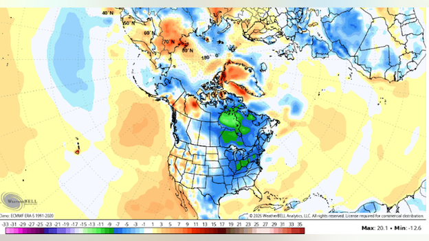
NOAA's Climate Forecast System model showing colder-than-average temperatures in mid-March across the eastern half of the U.S. (Source: WeatherBELL)
The clash between the lingering cold over the land and the relatively mild Atlantic waters creates a recipe for high-impact, moisture-rich snowstorms. Rather than a gradual warming trend, the Northeast is likely to experience "weather whiplash." Brief surges of mild, spring-like air will likely be followed by sharp, messy storms. For the millions of residents from D.C. to Maine, this means:
- Delayed planting: Soil temperatures are expected to remain below average, potentially pushing back the start of the growing season.
- Continued heating costs: The retreat of winter is being postponed, keeping energy demands high through the end of the month.
- Back-to-back storm threats: With the jet stream in a volatile state, the FOX Forecast Center is watching mid-March for more stormy weather along the East Coast.
As the atmosphere attempts to transition, the "guardrails" of typical winter are loosening. The result is a chaotic month where the calendar says spring, but the sky says otherwise.
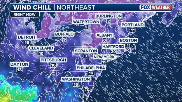
10 a.m. ET wind chill temperatures range from near 10°F along I-95 to -5°F across New England.
Relief from the dangerously cold air is slow to arrive in the Northeast, but there is progress being made. As of 10 a.m. ET, temperatures have jumped into the teens throughout much of the region with wind chills improving.
All of the cold weather alerts have now expired across the Northeast.
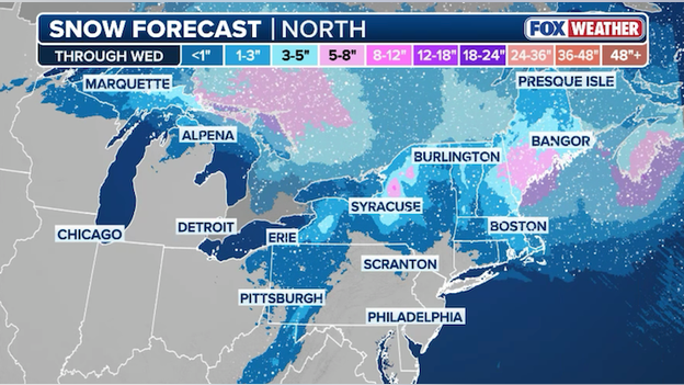
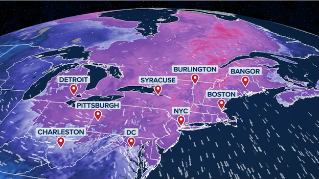
Latest snow forecast from FOX Weather showing the next round of snow for New England and the Northeast this week.
After a brief break, the Northeast and New England are in for more snow this week. Another clipper is poised to impact the region with a long-duration moderate snow through midweek. An area of low pressure will accelerate south of Canada and sweep through New England and the Northeast by Tuesday evening. The FOX Forecast Center says snow totals will generally be on the lighter side, but portions of the region could see up to a half foot of snow by Wednesday.

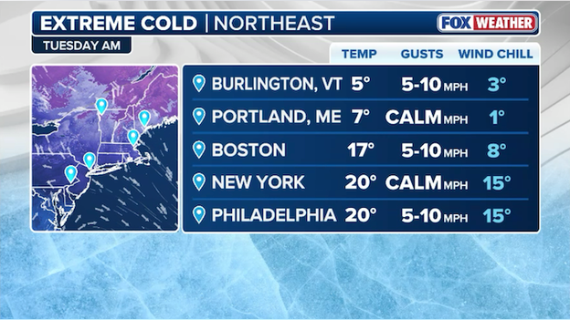
Temperatures and wind chills will still be cold on Tuesday morning, but not as brutal as Monday morning.
Millions of Americans in the Northeast are eagerly awaiting warmer weather following weeks of record-breaking cold. Tuesday morning, while still cold, won't be as brutal as this morning. Temperatures are expected to be slightly warmer and winds are expected to be calmer, which will result in less of an impact on wind chills.
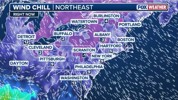
Wind chills remain dangerously cold throughout the Northeast as of 9 a.m. ET.
While the sun is shining, temperatures aren't budging yet. Wind chills remain near zero or below zero in many cities throughout the Northeast at this hour. With temperatures gradually warming up through the morning, conditions will improve in the hours ahead.
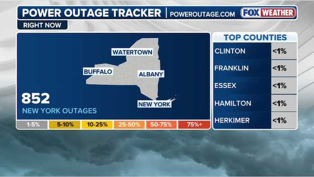
Latest power outage tracker showing more than 850 outages in New York. (PowerOutage.com)
Hundreds of people are without power across New York as temperatures reach dangerously low levels. Data from PowerOutage.com shows more than 850 homes and businesses are without power right now, likely representing more than a thousand people. Con Edison says it was responding to outages in Brooklyn and Queens caused by melting snow and salt hitting its equipment.
Boston remains under a Cold Emergency right now as the bitter cold bites Beantown. The current threshold for the City of Boston to declare a cold emergency is one day or more of -10°F or below observed wind chill. The city says there is an increased risk for hypothermia and frostbite for certain individuals, such as those experiencing homelessness, older residents, and young children. And the cold weather may also exacerbate health issues in high-risk populations.
...we are urging residents and families to take all necessary precautions to stay warm and safe and look out for your neighbors.
Mayor Wu has advised all residents to continue to take precautions, including reminding everyone to check in on older adults, people with disabilities, and people experiencing homelessness. If anyone sees someone experiencing homelessness out in the cold, they're asked to call 911.
If you like to marvel at the models, you've probably seen this: 60°F weather in New York City by the end of next week. In mid-February? What are the odds?
Any meteorologist will tell you that computer forecast models are just a guide. They provide forecasters with often times reasonable outcomes for future weather. And once you get beyond about 5-7 days in the future, things can get a little murky. But it's worth noting that trends in the models, even at 7 days out, often point to realistic outcomes.
The image below shows the ECMWF (European Centre for Medium-Range Weather Forecasts) model output for high temperatures in the Northeast on Thursday, February 19. It's depicting temperatures reaching the upper 50s and low 60s for the Mid-Atlantic and parts of the Northeast. With the polar vortex retreating back toward the Arctic and the overall weather pattern loosening up around the Northern Hemisphere, it's reasonable that places like New York could be in for a dramatic February warmup.
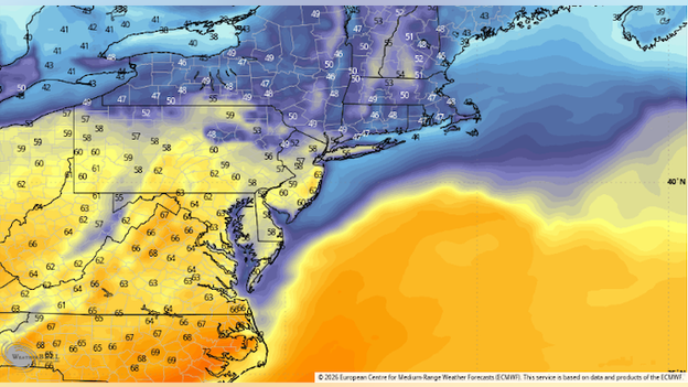
ECMWF (European Centre for Medium-Range Weather Forecasts) model showing a big warmup for the Northeast on Thursday, February 19. (Source: WeatherBELL)
And yes, it's not unheard of to see 60s in this part of the country in February. New York recently hit 57°F back in February 2025 and 62°F the year before. For now, the FOX Forecast Center says it will continue to monitor trends for a potential big warmup along I-95 in the next two weeks.
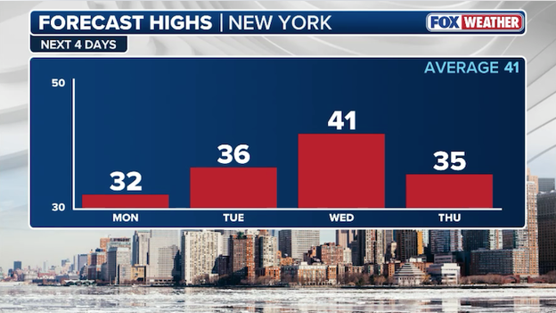
New York City is on track to warm into the 40s by Wednesday.
New Yorkers are ready for a warmup - and it's just hours away. After enduring nearly three weeks of record-breaking cold weather, the city is set to jump into the 40s midweek. The last time the city saw 40°F or warmer was back on January 22 when Central Park reached 47°F.
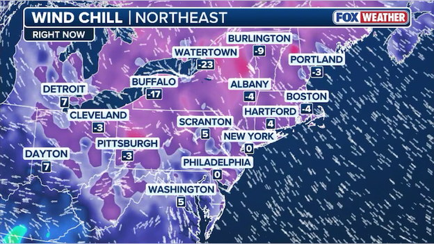
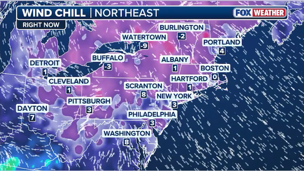
Wind chills are near 0°F along Interstate 95 throughout the Northeast right now.
As of 8 a.m. ET, wind chills remain brutal throughout the Northeast. Along the heavily-populated Interstate 95 corridor, millions of Americans are stepping out into life-threatening cold air with wind chills hovering around 0°F right now. In upstate New York, the combination of cold air and stronger winds has pushed wind chills to near -25°F in some places.
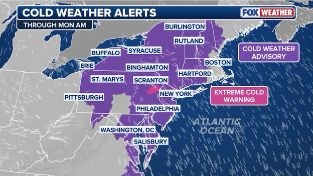
More than 60 million Americans are under Extreme Cold Warnings and Cold Weather Advisories this morning.
With dangerously cold air gripping the Northeast, Extreme Cold Warnings and Cold Weather Advisories are in effect for more than 60 million Americans right now. Those alerts are set to expire later this morning as temperatures warm up and the region finally begins to thaw following weeks of record-breaking cold weather.
Dangerously cold air blankets the Northeast with life-threatening wind chills for millions of Americans.
Millions of Americans are braving extreme cold this morning throughout the Northeast. Over 60 million people are under extreme cold warnings and cold weather advisories as temperatures and wind chills reach levels not seen in the region in years. This historic cold snap has already proven life-threatening, with officials confirming multiple fatalities due to exposure and mayors in cities like Boston declaring cold weather emergencies to protect vulnerable populations. Fortunately, this record-breaking freeze is on its last legs, with a dramatic weather whiplash on the way as temperatures jump into the 40s by midweek.
You’ve reached the beginning of this live coverage.