Live updates: Tornado danger grows across Plains, Midwest as severe weather outbreak continues
Live updates: Tornado danger grows across Plains, Midwest as severe weather outbreak continues
Download the AppTornado crossing caught on camera in Kansas
View postCoverage for this event has ended.
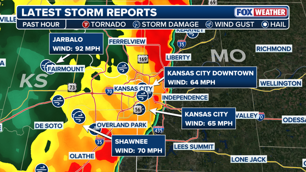
The latest storm reports in Kansas
Damaging wind gusts reaching 92 mph impacted areas west of Kansas City, Missouri, as the region braced for severe thunderstorms.
Tornado reports were issued across at least three states, including northeastern Kansas, southeastern Nebraska, and southern Iowa.
At the height of the storm, the National Weather Service issued a Severe Thunderstorm Warning with a destructive tag for wind gusts exceeding 80 mph.
However, by the time the storm moved into the Kansas City metro area, the winds were not as strong as initially expected.
Multiple tornadoes ripped across three states, including northeastern Kansas, southeastern Nebraska and southern Iowa, as severe thunderstorms struck the region.
In addition to tornado reports, damaging wind gusts of up to 90 mph and large hail battered parts of the Plains and Great Lakes.
More storms are expected throughout the night.
Flash Flood Warning issued for parts of Illinois and Missouri.
Parts of Illinois and Missouri are both under a Flash Flood Warning until 9 p.m. CT as severe storms continue.
Radar indicates that counties including Clinton, Madison, Monroe and St. Clair fall under the warning.
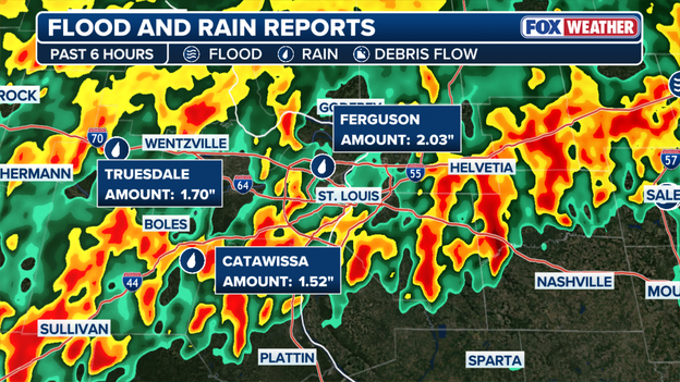
A few inches of rain have already been reported over the past 6 hours in Ferguson, Truesdale and Catawissa, according to the FOX Forecast Center.
Strong Nebraska tornado preliminarily rated an EF-3.
An intense tornado that impacted St. Libory, Nebraska, last night has been preliminarily rated a high-end EF-3.
Peak wind gusts were estimated to be 160 mph, according to the National Weather Service.
Officials said the tornado touched down at 5:04 p.m. CT and lifted about 10 minutes later.
The tornado strengthened as it rolled into a rural housing development, where four buildings appeared to be destroyed.
At least two more detached garage-type structures were destroyed, too.
The tornado also damaged power poles, trees and fencing as it moved east, the National Weather Service report said.
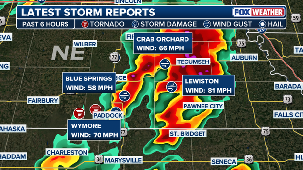
The latest storm reports in Nebraska.
Parts of Nebraska are seeing wind gusts up to 90 mph as the region experiences severe weather.
This comes as a confirmed tornado pummels its way east through the state.
In addition, the National Weather Service issued a Tornado Emergency for Pawnee City, Nebraska.
According to the FOX Forecast Center, the state is expected to experience dangerous tornadoes throughout the night, bringing damaging winds, large hail and heavy rain.
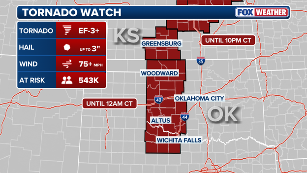
Tornado Watch issued in parts of Oklahoma and Kansas.
Over 540 million people are at risk of strong tornadoes (EF-3+) in Oklahoma and Kansas tonight.
A Tornado Watch is in effect through 12 a.m. CT for populated areas such as Oklahoma City and Wichita Falls.
Winds are gusting over 75 mph with hail reaching approximately 3 inches in size.
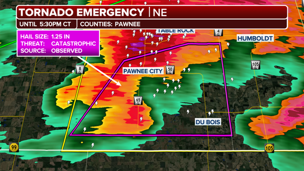
Tornado Emergency issued in Nebraska through 5:30 p.m. CT.
A Tornado Emergency has been issued for a portion of Nebraska as a strong storm slams the area.
The very dangerous, violent tornado is in progress in Pawnee County, with an emergency in effect through 5:30 p.m. CT.
A Tornado Emergency is the highest level of a tornado warning that can be issued.
People in the area should seek shelter immediately, as the storm could create catastrophic damage.
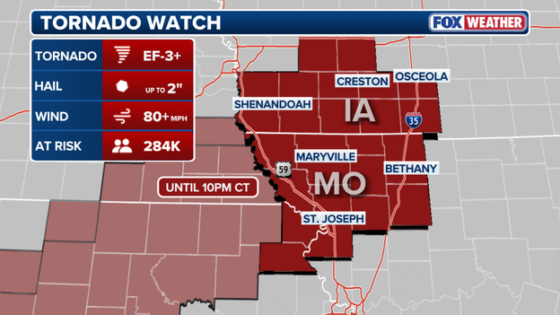
Tornado Watch issued for parts of Iowa and Missouri.
A Tornado Watch has been expanded to include parts of Iowa and Missouri through 10 p.m. CT.
Approximately 284,000 people are at risk of strong EF-3+ tornadoes as severe storms impact the area.
Wind gusts could exceed 80 mph with hail up to 2 inches, according to the FOX Forecast Center.
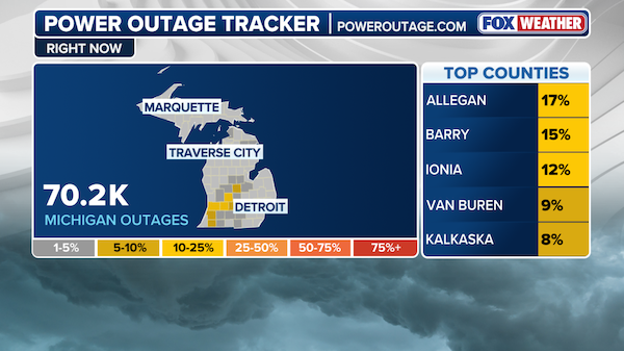
The number of Michigan customers without power.
As severe weather rages on across the Plains and Midwest, more than 70,000 Michigan residents are already without power, according to PowerOutage.us.
According to the FOX Forecast Center, severe thunderstorms producing wind gusts up to 80 mph are expected to impact parts of Michigan this evening.
NOAA’s Storm Prediction Center has issued a broad Level 2 out of 5 threat for the region.
Experts say the main threat will be damaging winds, hail and heavy rain, which could increase the power outages across the state.
Researchers with NOAA's National Severe Storms Laboratory are staged and ready to gather "unprecedented data" from tonight's storms.
Researchers with the LIFT campaign are staged in central Kansas, where they're expecting to capture data on tornadoes and hail.
NOAA said the environment today is highly supportive of severe weather.
The agency will be making observations to capture data near the surface to better understand hazards, and how environments are producing this type of severe weather.
Their vehicle is equipped with a high speed camera system to try and understand how hail falls and free fall to better detect and prepare for these events.
You can learn more about the LIFT campaign here.
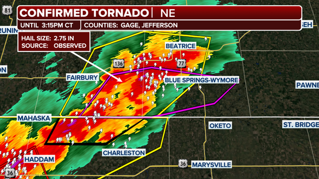
Confirmed tornado reported in Gage and Jefferson counties.
A confirmed tornado is moving through parts of Nebraska and people in the area should seek shelter immediately.
It's the first confirmed tornado of the night. An intense storm threat is currently impacting the Plains, with Nebraska falling in the highest impact threat zone.
Gage and Jefferson counties fall under the confirmed tornado warning, which remains in effect through 3:15 p.m. CT.
Hail up to 2.75 inches is also being reported. Storms are expected to continue overnight.
Severe thunderstorms capable of producing wind gusts up to 80 mph are possible as storms pummel Michigan tonight.
Wind gusts have already reached 60 to 75 mph. Straight-line winds could gust up to 80 mph along a localized corridor.

The storms are expected to maintain their intensity as they move eastward and cross central and southern Michigan, according to the National Weather Service.
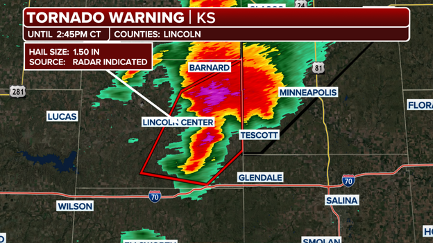
Tornado Warning issued for parts of Northeast Kansas.
A Tornado Warning has been issued for a storm system that is targeting Northeast Kansas heading toward the Minnesota state line.
The storm is moving toward Barnard and the Lincoln County area. The warning is in effect through 2:45 p.m. CT, according to the National Weather Service.
The area is also experiencing large hail up to 1.5 inches. Anyone in the area should seek shelter immediately.
A “Particularly Dangerous Situation,” or PDS, is wording the National Weather Service uses during especially dangerous severe weather events.
A PDS Tornado Watch means conditions are highly favorable for strong, long-track and potentially violent tornadoes.
A PDS Tornado Warning is even more serious and means a dangerous tornado is occurring or imminent.
These alerts are rare and are intended to grab attention when forecasters believe there is a heightened risk to life and property.

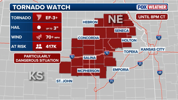
The Storm Prediction Center has issued a Tornado Watch for parts of Kansas until 9:00 p.m. ET.
A Particularly Dangerous Situation (PDS) Tornado Watch has been issued for parts of Kansas, including Salina, until 9:00 p.m. ET as forecasters warn conditions are becoming highly favorable for strong and potentially long-track tornadoes this afternoon and evening.
A PDS Tornado Watch is a rare and more serious type of tornado watch issued only when meteorologists have high confidence that dangerous, potentially life-threatening tornadoes could develop.
It signals an increased risk for intense tornadoes capable of causing significant damage, along with giant hail and destructive winds.
People across the watch area are urged to closely monitor weather conditions, have multiple ways to receive warnings and be prepared to take shelter immediately if Tornado Warnings are issued later today.
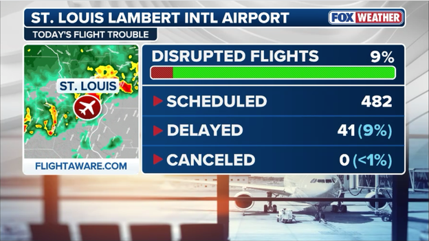
The FAA has issued a ground stop for St. Louis Lambert International Airport until 3:00 p.m. ET as thunderstorms continue impacting the region.
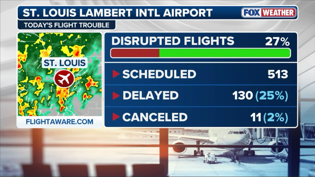
The Federal Aviation Administration has issued a ground stop for St. Louis Lambert International Airport until 3:00 p.m. ET.
Heavy rain, lightning and strong storms moving through the St. Louis metro are disrupting airport operations and causing delays for travelers.
A ground stop means flights destined for the airport are temporarily being held at their departure airports until conditions improve.
Passengers traveling through St. Louis should check with their airlines for the latest flight updates as severe weather continues across the Midwest.
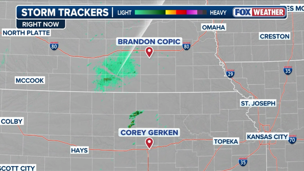
FOX Weather exclusive storm trackers Brandon Copic and Corey Gerken are standing by to track today's severe storms in Kansas and Nebraska.
FOX Weather Exclusive Storm Trackers Brandon Copic and Corey Gerken are now prepositioning across Nebraska and Kansas ahead of today’s potentially dangerous severe weather outbreak.
The storm tracker are strategically positioning themselves near the expected storm development zone, where forecasters warn supercells capable of producing giant hail, destructive winds and strong tornadoes could rapidly develop later this afternoon and evening.
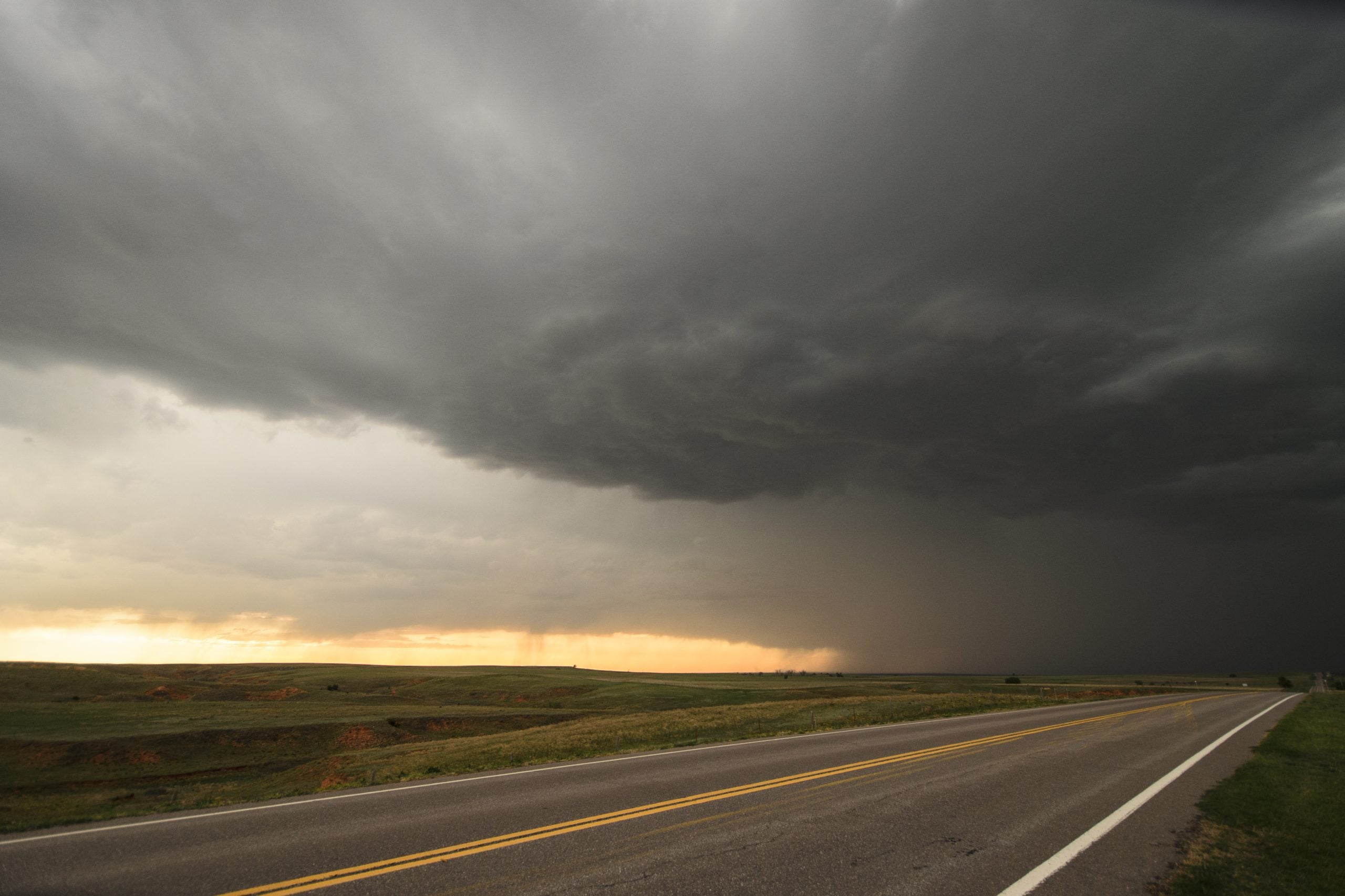
Towering cumulus clouds are beginning to bubble across parts of Kansas this afternoon, a sign that the atmosphere is rapidly destabilizing ahead of a potentially dangerous severe weather outbreak.
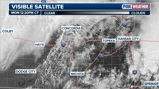
GOES-East visible satellite image showing cumulus clouds bubbling up over Kansas ahead of today's expected severe weather.
Meteorologists closely watch these growing clouds because they often signal that warm, humid air is rising quickly into the atmosphere — one of the final steps before thunderstorms explode into development.
With extreme instability and powerful wind shear already in place, forecasters expect severe thunderstorms capable of producing giant hail, destructive winds and tornadoes to begin developing over the next few hours.
Heavy rain and flash flooding remain a growing concern along and north of the Interstate 44 corridor from southeastern Kansas through Missouri and into southern Illinois as thunderstorms continue to repeatedly move over the same areas.
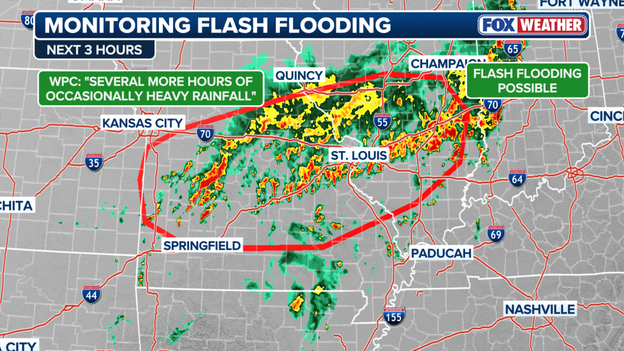
Meteorologists are monitoring thunderstorms that are "training" over the same areas, raising the threat for flash flooding this afternoon.
FOX Weather meteorologists say a large complex of storms stretching from near Fort Scott, Kansas, through the St. Louis metro and into south-central Illinois is becoming more organized in a way that favors “training” thunderstorms — storms that move repeatedly over the same locations like train cars on a track.
While rain rates may not be extreme at any one moment, the persistence of the storms could allow several inches of rain to pile up over a few hours.
The FOX Forecast Center warns some areas could see around 2.5 inches of rain in three hours, especially in urban and low-lying locations where flash flooding can develop quickly. The flood threat is expected to continue through at least late afternoon.
The Storm Prediction Center says a Tornado Watch will likely be issued soon for parts of south-central Kansas into southeastern Nebraska and northwest Missouri as the atmosphere rapidly becomes primed for dangerous severe weather.
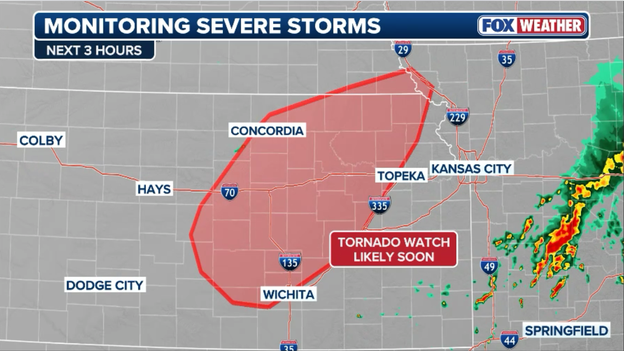
The Storm Prediction Center says conditions are becoming favorable for severe storms to erupt across Kansas this afternoon.
Forecasters say warm, humid air surging northward into Kansas is helping thunderstorms begin to develop along a cold front and nearby boundaries left behind by earlier storms.
The FOX Forecast Center is especially concerned because winds near the ground are turning sharply with height — a key ingredient that can help thunderstorms rotate and produce strong tornadoes.
Any storms that form this afternoon could quickly become supercells capable of producing giant hail, destructive winds and strong to intense tornadoes.
Forecasters say the greatest concern is for isolated storms that can remain separate from each other, since those storms have the highest potential to produce long-track tornadoes before eventually merging into a larger line of storms later tonight.
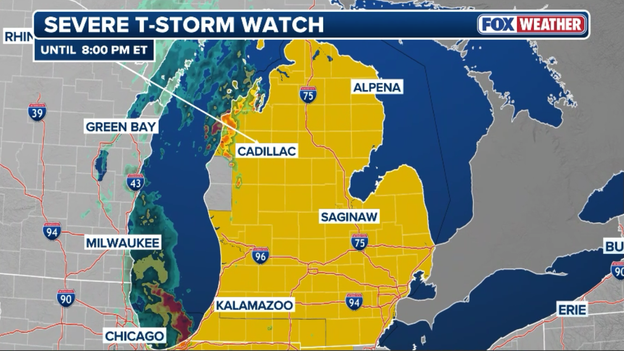
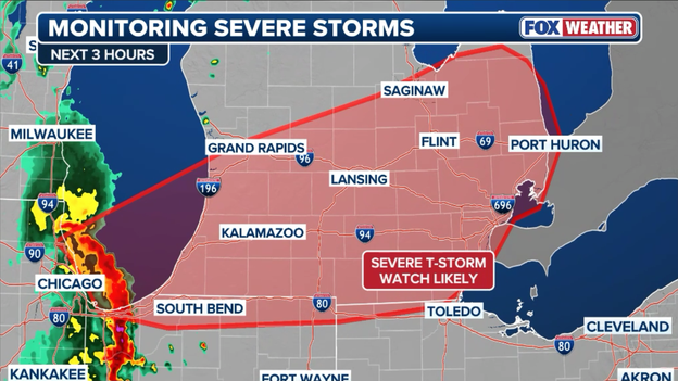
The Storm Prediction Center has issued a Severe Thunderstorm Watch for most of Michigan until 8:00 p.m. ET.
A new Severe Thunderstorm Watch has been issued for parts of Michigan until 8 p.m. ET as a powerful line of storms pushes eastward across the state.
The Storm Prediction Center warns the storms could produce damaging wind gusts up to 80 mph, frequent lightning, torrential rain and isolated hail.
The threat comes as a fast-moving bow echo moves inland from Lake Michigan, bringing the potential for widespread wind damage.
People across the watch area should stay alert for rapidly changing weather conditions and be prepared for possible severe thunderstorm warnings later this afternoon and evening.
The Storm Prediction Center says it will issue a new Severe Thunderstorm Watch soon for portions of the Great Lakes.
A powerful line of severe thunderstorms is racing across Lake Michigan and into parts of lower Michigan this afternoon, prompting forecasters to warn that a new Severe Thunderstorm Watch will likely be issued soon.
The Storm Prediction Center says the northern edge of the bow echo — a fast-moving, bow-shaped line of storms known for producing destructive straight-line winds — could bring wind gusts between 65 and 80 mph as it moves inland.
The storms are feeding off a very unstable atmosphere, allowing powerful downdrafts to develop along the leading edge of the line.
People across lower and central Michigan should be prepared for damaging winds capable of knocking down trees and power lines as the storms continue pushing eastward through the afternoon.
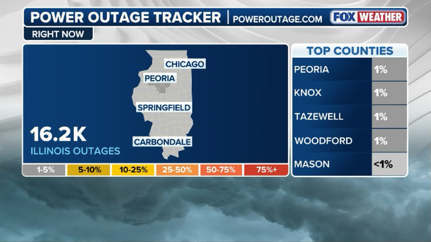
Power outage tracker for Illinois showing more than 16,000 customers now without power. (PowerOutage.com)
Power outages are climbing across Illinois after severe thunderstorms blasted the state with damaging winds and heavy rain.
More than 16,000 customers are now without electricity as utility crews work to restore power following the storms.
The outages come after powerful winds swept across parts of the Chicago metro and northern Illinois, toppling tree limbs and damaging power lines.
Chicago is beginning to assess storm damage after severe thunderstorms ripped through the metro area with wind gusts topping 75 mph.
The powerful storms knocked down tree limbs, caused scattered power outages and disrupted travel across the city as heavy rain and dangerous winds swept through the region. Officials are continuing to evaluate reports of damage while cleanup crews work to clear debris left behind by the fast-moving storms.
A powerful 79 mph wind gust was recorded at Chicago Midway International Airport as severe thunderstorms swept through the Chicago metro area Monday.
The intense winds, equivalent to a low-end Category 1 hurricane, blasted through the airport as storms brought heavy rain, dangerous lightning and rapidly changing conditions across the city.
The severe weather has also caused flight delays and ground stops at Chicago-area airports throughout the day.
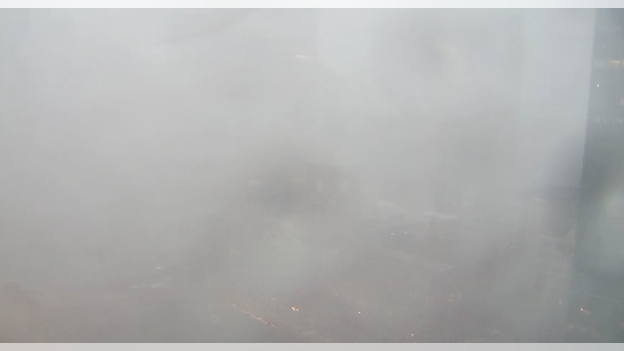
FOX Weather camera in downtown Chicago showing heavy rain hammering the city.
Chicago's magnificent skyline has disappeared as severe thunderstorms bear down on the city.
FOX Weather's camera downtown shows torrential rain hammering the city as storms barrel through the metro.

Camera in downtown Chicago showing ominous clouds approaching the city.
FOX Weather cameras captured ominous dark clouds rolling toward downtown Chicago as severe thunderstorms slammed the metro area Monday morning.
The National Weather Service has issued a Severe Thunderstorm Warning until 11:30 a.m. CT for the metro area.
The Federal Aviation Administration has issued a ground stop for Chicago Midway Airport until 12:45 p.m. ET.
The FAA has issued a ground stop for Chicago Midway International Airport until 12:45 p.m. ET as severe thunderstorms move across the Chicago metro area.
The dangerous weather is bringing heavy rain, lightning and strong winds to the region, forcing air traffic officials to temporarily slow arrivals for safety reasons.
A ground stop means flights destined for Midway are being held at their departure airports until conditions improve.
Travelers should expect delays and check with their airlines for the latest flight information as storms continue to impact operations across Chicago-area airports.
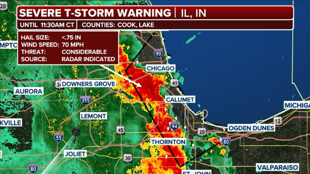
The National Weather Service has issued a Severe Thunderstorm Warning for Chicago until 11:30 a.m. CT.
A Severe Thunderstorm Warning has been issued for the Chicago area until 11:30 a.m. CT as strong storms move through the metro.
The storms are capable of producing damaging wind gusts, torrential rain, frequent lightning and small hail. Residents are urged to move indoors immediately and avoid travel if possible as the line of storms pushes across the city.
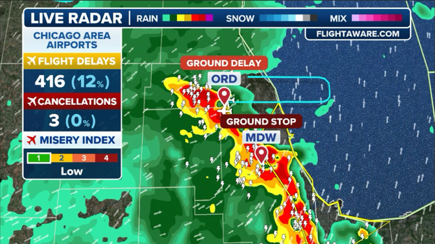
Flights at Chicago-area airports are also experiencing delays as the dangerous weather impacts the region.
Severe thunderstorms approaching the Chicago metro are beginning to disrupt air travel across the region, with delays steadily mounting at area airports.
According to Federal Aviation Administration data, flights destined for Chicago O’Hare International Airport are averaging delays of about 1 hour and 15 minutes before takeoff as storms move closer to the city.
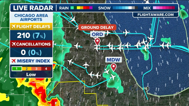
The FAA says flights destined to Chicago's O'Hare International Airport are facing growing delays as thunderstorms interrupt airport operations.
Dangerous weather, including strong winds, lightning and heavy rain, can force airlines and air traffic controllers to slow operations for safety reasons.
Travelers flying into or out of Chicago this afternoon should check directly with their airlines for the latest flight updates as conditions continue to deteriorate.
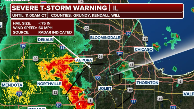
The National Weather Service has issued a Severe Thunderstorm Warning for parts of Grundy, Kendall, and Will Counties in Illinois until 11:00 a.m. CT.
Severe thunderstorms are approaching the Chicago metro area from the southwest as a line of strong storms pushes across northern Illinois this morning.
The storms could bring damaging wind gusts, torrential rain, frequent lightning and pockets of hail as they move into the city and surrounding suburbs.
Residents across the Chicago area should be prepared for rapidly changing weather conditions and possible Severe Thunderstorm Warnings as the line moves through.
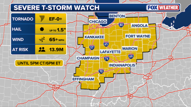
The Storm Prediction Center has issued a Severe Thunderstorm Watch for portions of Illinois and Indiana until 5 p.m. CT.
A new Severe Thunderstorm Watch has been issued for parts of Illinois and Indiana, including Chicago and Indianapolis, through 6 p.m. ET (5 p.m. CT) as strong to severe storms move across the Midwest.
Forecasters warn the storms could produce damaging wind gusts, large hail and frequent lightning as they track eastward through the afternoon.
Residents across the watch area should stay alert for rapidly changing weather conditions and be prepared for warnings later today.
Remember, a watch means conditions are favorable for severe storms to develop in and near the watch area.
When severe weather threatens, one of the most important things to understand is the difference between a watch and a warning.
A watch means conditions are favorable for dangerous weather to develop. For example, a tornado watch means the atmosphere is capable of producing tornadoes.
During a watch, you should stay alert, monitor forecasts and be ready to act quickly if conditions worsen.
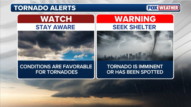
The National Weather Service is responsible for issuing watches and warnings to help protect lives and property across America.
A warning means dangerous weather is happening or about to happen. A tornado warning is issued when a tornado has been spotted or detected on radar.
At that point, you should take action immediately and move to a safe place.
A simple way to remember it: A watch means “be prepared,” while a warning means “take action now.”
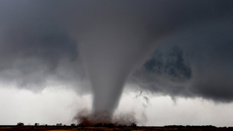
A dangerous weekend severe weather outbreak swept across the central U.S., producing tornadoes, giant hail, destructive winds and life-threatening flash flooding across more than a dozen states.
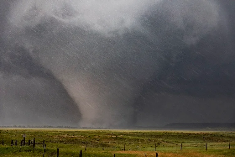
The most dramatic scenes came out of Nebraska on Sunday, where a powerful tornado prompted the National Weather Service office in Hastings to issue a rare Tornado Emergency for Thayer County, including the city of Hebron.
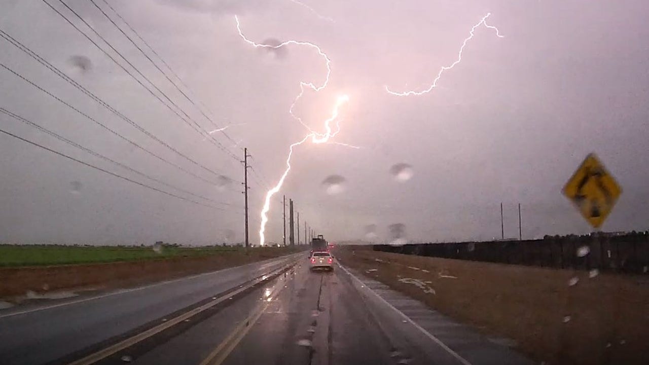
Video captured the massive tornado churning across the Plains as storms intensified across the region.
Over the course of Saturday and Sunday, forecasters received well over 400 severe weather reports, after issuing more than 70 Tornado Warnings and over 400 Severe Thunderstorm Warnings.
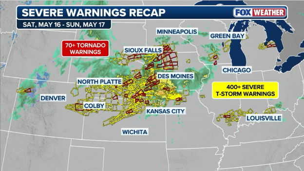
The National Weather Service issued over 70 Tornado Warnings and 400 Severe Thunderstorm Warnings this weekend across the central U.S.
More than 50 reports involved significant hail or damaging winds stretching from South Dakota and Nebraska through Kansas, Iowa and even parts of Michigan.
The largest hailstone reported during the outbreak measured an incredible 3.5 inches in diameter near Palmer, Nebraska.
Flooding also became a major threat during the outbreak. On Saturday, the National Weather Service in Kansas City issued a Flash Flood Emergency for Grundy County, Missouri, including the city of Trenton, after more than 8 inches of rain fell and dangerous flooding rapidly developed.
The FOX Forecast Center says this morning’s thunderstorms across Kansas and Missouri could play a major role in determining how dangerous today’s severe weather outbreak becomes later this afternoon and evening.
The storms are producing cooler rain-cooled air and cloud cover, which could temporarily slow the atmosphere’s recovery.
But if enough sunshine breaks through by this afternoon, temperatures rising into the 80s combined with rich Gulf moisture and powerful upper-level winds could rapidly create an explosive environment for severe thunderstorms.
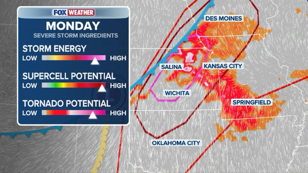
The FOX Forecast Center says all the ingredients are coming together for a severe weather outbreak in the Plains and Midwest later this afternoon-evening.
FOX Weather meteorologists say isolated supercells may develop across central and northeastern Kansas into southeastern Nebraska by late afternoon.
Those storms could quickly become capable of producing giant hail, strong tornadoes and destructive winds before eventually merging into a larger line of storms tonight.
Thunderstorms pounding the St. Louis area are now causing some incoming flights to divert to other airports as dangerous weather moves over St. Louis Lambert International Airport.
The diversions come as lightning, heavy rain and strong storms continue to impact airport operations across the region. Travelers heading to or through St. Louis should expect delays and possible schedule changes as airlines work around the severe weather.
Thunderstorms moving through the St. Louis area prompted the Federal Aviation Administration to issue a ground stop for St. Louis Lambert International Airport through 11:30 a.m. ET.
The Federal Aviation Administration has issued a ground stop for St. Louis Lambert International Airport until 11:30 a.m. ET Monday.
A ground stop temporarily prevents flights bound for the airport from taking off at their departure airports, helping reduce congestion and improve safety during dangerous weather.
Travelers should expect delays and check directly with their airlines for the latest flight information as storms continue to impact the region.
A potentially dangerous severe weather outbreak is expected across parts of the Plains today, especially in Kansas and southeastern Nebraska, where the Storm Prediction Center has issued a Level 4 out of 5 severe weather risk.
FOX Weather meteorologists say sunshine and surging humidity will help fuel explosive thunderstorm development by mid-to-late afternoon. Cities including Wichita, Topeka, Salina and Manhattan are in the highest threat zone.
The first storms that develop are expected to become rotating supercells capable of producing strong tornadoes, destructive winds and giant hail as large as baseballs or softballs.
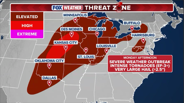
Exclusive FOX Weather Threat Zone shows where severe storms capable of producing tornadoes, large hail, and damaging winds are most likely through the evening and overnight hours.
However, meteorologists say the tornado threat could depend on how long storms remain isolated before merging into a larger line of storms.
If storms quickly cluster together, the threat could shift more toward widespread damaging winds later tonight.
Flash flooding is also a concern from Missouri into Iowa, where repeated rounds of storms could dump 3 to 5 inches of rain in a short amount of time.
You’ve reached the beginning of this live coverage.