Live updates: Intense tornadoes, large hail threaten 132 million from Midwest to Northeast
Live updates: Intense tornadoes, large hail threaten 132 million from Midwest to Northeast
Download the AppLIVE coverage has moved
View postCoverage for this event has ended.
Wednesday, April 15, 2026: The severe weather outbreak continues this morning as dangerous flooding inundates Michigan and Wisconsin, while new tornado threats emerge for over 14 million people from Chicago to Detroit. Following yesterday’s destructive 88 mph winds and giant hail, we are tracking the next wave of life-threatening storms.
LATEST UPDATES: Click here for the new FOX Weather Live Blog to track today's tornadoes, flooding, and severe storm alerts.
A dangerous and widespread severe weather outbreak is unfolding across the Midwest Tuesday, with multiple states already reporting tornadoes, massive hail and destructive wind gusts as storms continue to track through the region.
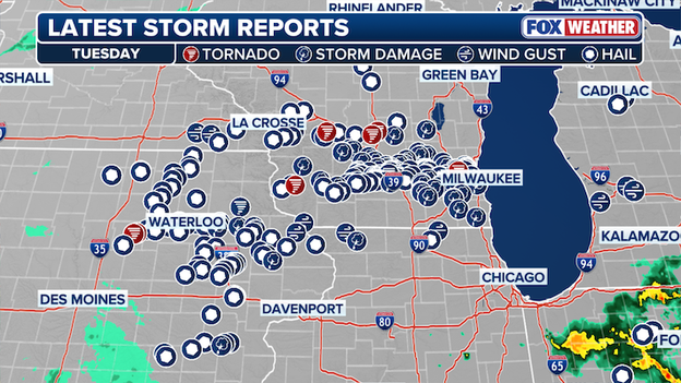
Tuesday Storm Reports in the Midwest.
Storm reports have been rapidly coming in throughout the afternoon and evening, including large hail capable of causing significant damage, powerful wind gusts knocking down trees and power lines and multiple confirmed tornadoes.
The severe storms have stretched across a broad swath of the Midwest, impacting numerous areas across the region.
Tuesday's severe weather outbreak is just the beginning of a marathon of storms that stretch into tomorrow.
Areas that were slammed by tornadoes, massive hail and damaging wind gusts on Tuesday will see another round of storms Wednesday afternoon. A level 2/5 severe storm risk stretches from the southern Plains to the Midwest and also includes portions of the Ohio Valley and Northeast.
Stay with FOX Weather for the latest updates on this ongoing severe weather outbreak.
While a widespread severe weather outbreak placed millions at risk for destructive, large hail across the central U.S., the largest hailstones reported Tuesday were concentrated in Wisconsin.
From the Madison area to surrounding communities, intense thunderstorms produced giant hail up to 3.25 inches in diameter—comparable to the size of a tennis ball—capable of causing significant damage to vehicles, roofs, and crops.
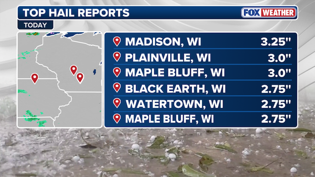
Top Hail Reports from Tuesday
Largest Hail Reports on Tuesday
- Madison, WI — 3.25”
- Plainville, WI — 3.00”
- Maple Bluff, WI — 3.00”
- Black Earth, WI — 2.75”
- Watertown, WI — 2.75”
- Maple Bluff, WI — 2.75”
A powerful severe weather outbreak swept across the central United States Tuesday, unleashing destructive winds, large hail, and the threat of tornadoes from Texas through the Midwest and into the Great Lakes, with the threat lingering into Wednesday.
Intense straight-line winds, with several locations clocking hurricane-force gusts were registered across a widespread area impacted by the massive severe weather outbreak on Tuesday.
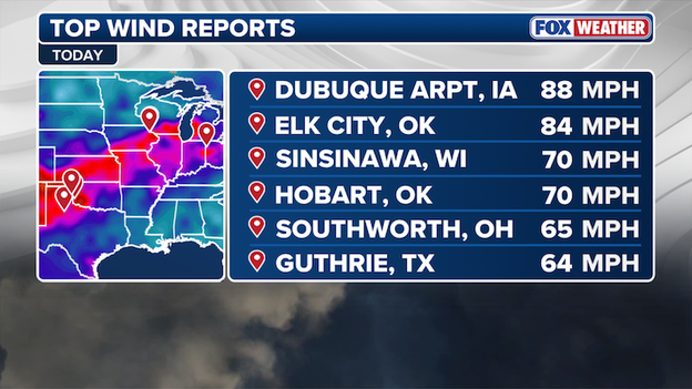
Top Wind Reports
Top Wind Gusts Reported Tuesday
- Dubuque Airport, Iowa — 88 mph
- Elk City, Oklahoma — 84 mph
- Sinsinawa, Wisconsin — 70 mph
- Hobart, Oklahoma — 70 mph
- Southworth, Ohio — 65 mph
- Guthrie, Texas — 64 mph
Stay with FOX Weather for the latest on the severe weather outbreak and its impacts on travel as storms continue to move across the Midwest.
A ground stop has been issued at Chicago O’Hare International Airport as severe storms sweep across the Midwest, bringing dangerous weather and significant travel disruptions to one of the nation’s busiest hubs.
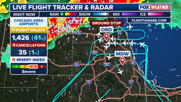
Live Flight Tracker and Radar
The ground stop, which is subject to an extension, is in place until 11:45 pm ET.
After a full day of monitoring severe storms, FOX Weather Meteorologist Haley Meier provides a final update, recapping the widespread outbreak and key impacts observed throughout the day.
A tornado watch has been issued for parts of Indiana and Michigan until 4 AM EDT.
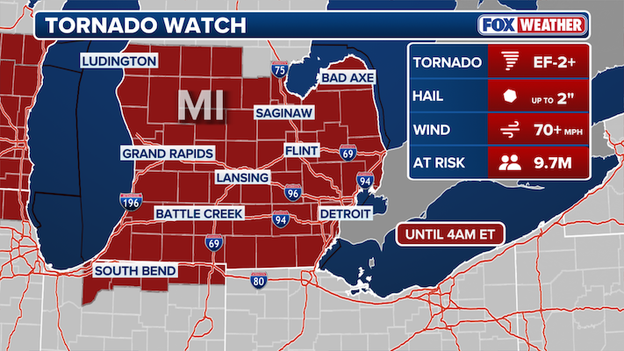
Tornado Watch Map
A couple of tornadoes are possible, scattered hail 2" in diameter and scattered gusts up to 70 mph are likely.
More than 75 vehicles were involved in a massive crash on Interstate 70 in Colorado on Tuesday afternoon and over a dozen people are injured.
The Clear Creek County Sheriff's Office said the crash is blocking I-70 East and Highway 6 East in Silverthorne near the Eisenhower Tunnel.
Colorado State Patrol said 19 people are being taken to the hospital with varying injuries. No deaths have been reported at this time.
Drivers are being rerouted over Loveland Pass, however, due to the severity of the crash, drivers approaching the Eisenhower Tunnel should expect to be turned around.
The Colorado Department of Transportation said snowy conditions are being reported throughout the I-70 mountain corridor.
The sheriff's office said injuries have been reported, but the extent is unknown.
The highway remains closed and there is no estimated time for it to reopen.
Severe storms unleashed damaging hail across parts of the Midwest, leaving communities in Indiana like Sweetser and Marion dealing with significant impacts in the aftermath.

Courtesy of Grant County Sheriff's Office - Marion, IN
Window-shattering hail pounded the area, causing widespread damage across parts of Grant County.
The Grant County Sheriff's Office reported widespread damage from severe storms.
The storms are part of a broader severe weather pattern affecting multiple states in the U.S., with threats ranging from large hail to damaging winds and tornadoes.
Stay with FOX Weather for continuing coverage as we track ongoing severe weather threats and the recovery efforts in hard-hit communities.
Powerful storms sweeping across Wisconsin have left at least 25,000 customers without electricity as a dangerous severe weather outbreak continues to impact the region, according to data from poweroutage.com.
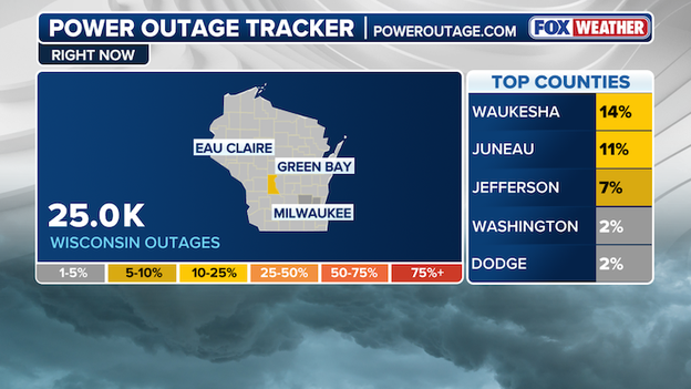
Power Outage Tracker courtesy of poweroutage.com
Ongoing threats from strong thunderstorms—including damaging wind gusts, large hail and possible tornadoes are impacting the region.
The storms are part of a larger, multi-state severe weather outbreak that has placed millions under alerts, with conditions expected to remain volatile into the evening.
Stay with FOX Weather for the latest updates as this severe weather outbreak continues to unfold.
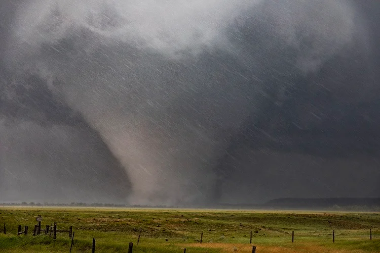
FOX Weather Meteorologist Haley Meier and the FOX Weather Beast Team intercept a tornado in Wyoming, Iowa, as a dangerous severe weather outbreak unfolds.
Live from the FOX Weather studio, Meteorologist Steve Bender breaks down the widespread threat, that has millions under threat into the evening.
Stay with FOX Weather as we continue to track this high-impact outbreak in real time.
A team of FOX Forecast Center meteorologists and Storm Trackers is deployed in the field, monitoring a dangerous severe weather outbreak that has more than 11 million people under Tornado Watches through this evening.
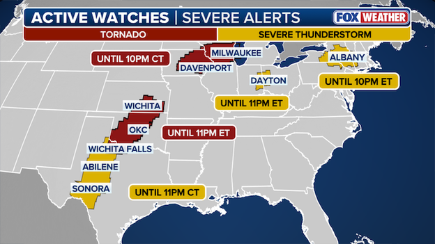
FOX Weather Active Watch Map
Severe weather alerts are active across multiple regions of the U.S., with storms capable of producing tornadoes, damaging winds and large hail.
Stay with FOX Weather as we track this evolving threat in real time and bring you the latest updates from the field.
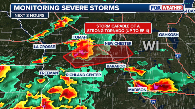
A confirmed tornado has been reported in Juneau County, Wisconsin, prompting the National Weather Service to issue a Particularly Dangerous Situation (PDS) warning.
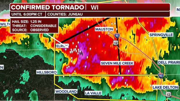
Confirmed Tornado in Juneau County
The “large and extremely dangerous tornado” was located near Elroy, about 8 miles southwest of Mauston, moving east at 35 mph.
The NWS warns that this tornadic thunderstorm is impacting Lindina, Lemonweir, Pleasant Ridge, Mullin Ridge, and the Bass Hollow Recreation Area. Interstate 90/94 between mile markers 67 and 72 is also in the storm’s path.
The FOX Forecast Center is tracking a dangerous storm in southwestern Wisconsin with the potential to produce a strong tornado. Forecasts indicate a possible peak intensity in the EF-3 to EF-4 range over the next several hours.
FOX Forecast Center is monitoring severe weather in the U.S.
The Storm Prediction Center has identified a supercell in Vernon County that is showing increasing organization, signaling a growing risk of significant tornadic development. This system could produce a tornado packing dangerous winds of 140–170 mph, along with large hail ranging from 2.75 to 4.25 inches in diameter.
Stay with FOX Weather as we continue to monitor severe weather threats across the United States.
With more than 11 million people across seven states under a Tornado Watch, a major concern is the potential for softball-sized hail—and the significant damage it can inflict in a short amount of time.
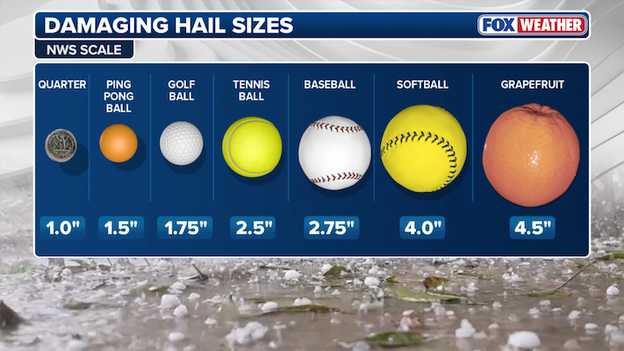
FOX Weather Hail Scale
According to the FOX Forecast Center, softball-sized hail can fall at speeds approaching 100 mph. At that velocity, these ice projectiles—comparable to a Major League fastball—can cause significant damage, shattering windshields and leaving a trail of destruction across homes and property.
Scattered hail up to 4 inches in diameter—roughly the size of a softball—is expected across parts of Kansas, Oklahoma, and Texas. Meanwhile, a more widespread threat of similarly large softball size hail is forecast for portions of Illinois, Iowa, Minnesota, and Wisconsin, as millions brace for severe weather through the evening hours.
Softball size hail far from a home run scenario. The potential for serious damage is very real when hailstones of this size come crashing down. A dramatic example occurred in March, when a massive hailstone punctured FOX Weather Exclusive Storm Tracker Brandon Copic’s windshield—capturing a jaw-dropping moment that underscores just how dangerous these storms can be.
For the more than 11 million Americans under a Tornado Watch, the threat of damaging hail is a serious concern. These powerful storms can produce large, fast-falling hail capable of causing significant damage in a matter of seconds.
Stay with FOX Weather as we continue to track these severe storms and bring you the latest updates into the evening.

Evacuations are underway and residents are being advised to take precautions as water continues to rise at the Cheboygan Dam in Michigan.
Recently, the region has experienced significant snow and rain, which have contributed to rising water levels at the Cheboygan Dam and led to a potentially imminent collapse of the structure any day now.
The dam is just 7 inches away from reaching the top, according to Michigan State Emergency Management and Homeland Security.
Just Sunday afternoon, the water levels were 15 inches below the top of the dam.
In an update from the Cheboygan County Sheriff's Office, officials said a levee breach is causing the evacuation of low areas near the Little Black River Watershed. Officials said the issue is not related to the dam.
Officials suggest residents prepare by packing and getting their family, pets and vehicle ready for potential departure.
FOX Weather Exclusive Storm Tracker Brandon Copic tracked a warned storm in Eldora, Iowa, while FOX Weather meteorologist Ian Oliver guided viewers through the system and discussed the storm with Copic from the studio as it unfolded in real time.
A Tornado Watch has been issued for parts of Kansas, Oklahoma and Texas, putting another 3+ million people under threat through 11 p.m. CDT.
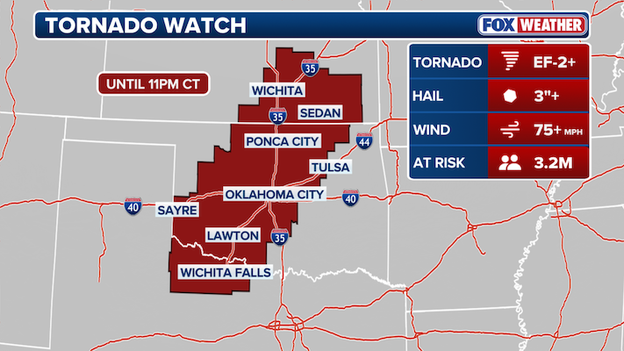
Tornado Watch map
A couple of strong tornadoes are possible, softball size hail is likely and scattered wind gusts up to 75 mph is likely.
This is the second watch issued today amid a severe weather threat that has placed more than 11 million people under a Tornado Watch. Portions of Illinois, Iowa, Minnesota, and Wisconsin are included through 10 PM CDT and face a similar threat across the Great Plains.
Stay with FOX Weather as we continue tracking the tornado risk into the evening.

Flooding reported at Pellston Regional Airport in Pellston, Michigan, on April 14, 2026.
Pellston Regional Airport in Michigan is closed after significant rain caused flooding on both of their runways.
The airport said as much as 10 to 12" of rain accumulated in some areas, and as a result, the airport will be closed through at least Friday.
Officials said they will reexamine the flooding and make a decision about reopening then.
"There are many things including debris removal, hard surface and soil erosion factors that will need to be evaluated and completed after the water hazard is gone before we resume normal flights," the airport said on Facebook.
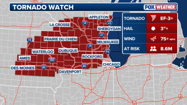
A Tornado Watch has been issued for parts of Illinois, Iowa, Minnesota and Wisconsin.
The National Weather Service has issued a Tornado Watch for several Midwest states through 10 p.m. CDT.
Roughly 8.6 million people fall in the threat zone - which includes Illinois, Iowa, Minnesota and Wisconsin - with wind gusts over 75 mph expected.
Hail could reach up to 3" in size and tornadoes could reach EF-2 strength or higher, according to the FOX Forecast Center.
A local state of emergency has been declared in Menominee County, Michigan, as rising floodwaters continue to create dangerous conditions.
The Menominee County Sheriff's Office said there are impassible roads, sinkholes, washed out bridges and flooding to homes and businesses.
Utilities and infrastructure have also been impacted by flooding.
The sheriff's office said the Menominee River is expected to rise for another 24 to 48 hours, and they're urging residents to have a flood emergency plan.
Officials said people should also use extreme caution near standing and moving floodwaters.
"Do not drive through flooded areas - unseen hazards may exist below the water's surface," the sheriff's office said on Facebook.
The Storm Prediction Center says it will likely issue a Tornado Watch in the Midwest this afternoon.
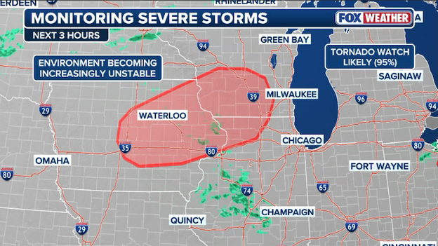
The severe weather threat is rapidly intensifying across the Midwest this afternoon as the atmosphere primes for a significant outbreak of supercells.
The Storm Prediction Center is closely monitoring a corridor from eastern Iowa into southern Wisconsin and northern Illinois, where extreme instability and increasing wind shear are expected to trigger "giant" hail and intense tornadoes.
With the environment reaching a breaking point, a Tornado Watch is highly likely to be issued shortly for the region, including major hubs like Des Moines, Dubuque, and Madison, as discrete storm cells begin to ignite along a stalled warm front.
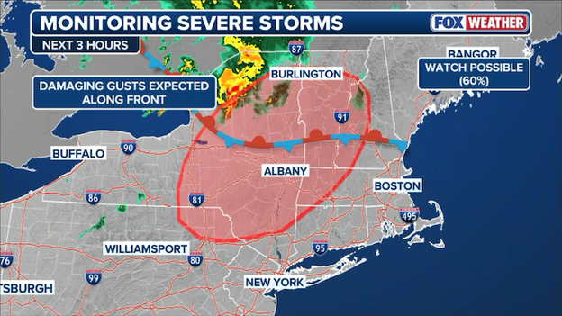
Severe storms are expected to develop across portions of the Northeast through this evening.
The FOX Forecast Center is monitoring the Northeast this afternoon as the atmosphere destabilizes from Pennsylvania to Vermont. With a disturbance moving through and cloud cover breaking, temperatures are rising, creating a primed environment for a band of severe storms to develop.
The Storm Prediction Center is currently considering a Severe Thunderstorm Watch for the region in the next few hours, as these storms could bring damaging wind gusts and localized hail to the I-87 corridor and beyond through the evening.
The Storm Prediction Center is navigating a complex and volatile afternoon as an upper-level disturbance moves across the Upper Midwest, clashing with a surging mass of warm, moist air.
Forecasters are keeping a close watch on a warm front draped across Iowa, southern Wisconsin, and northern Illinois, where they expect intense supercells to ignite by mid-afternoon.
Because the air high above the ground is cooling rapidly (steep lapse rates) and wind speeds are increasing with height, these storms will be capable of producing giant hail—potentially 3 to 4 inches in diameter—and a few intense tornadoes (EF-3 intensity), specifically for any storms that can stay rooted on the warmer southern side of the boundary.
The Storm Prediction Center has issued a Level 3 of 5 severe weather threat zone across 15 states today.
The SPC says while there was a strong case for upgrading the region to a Level 4 of 5 risk, meteorologists held off for now due to uncertainty regarding how quickly these individual supercells might clump together into a solid line.
If the storms congeal quickly, the threat would shift from tornadoes to a widespread swath of damaging wind gusts as the system races into Michigan tonight.
Farther south, into central Illinois, Indiana, and Ohio, the risk is more uncertain but still dangerous; here, leftover outflow boundaries from morning rain could serve as the tripwire for additional supercell development in an even more unstable environment.
A dangerous combination of record-breaking snowpack and relentless rain has pushed the Great Lakes region into a high-stakes flooding emergency.
The FOX Forecast Center warns that as heavy rain falls on frozen ground and rapidly melting snow, local rivers across Wisconsin and Michigan are expected to surge into major flood stage, with several locations forecast to shatter all-time record crests through Wednesday.
The atmospheric setup is fueled by a moisture pump off the Southeast coast that is funneling an endless stream of Gulf moisture directly into the Upper Midwest. This has created a perfect storm for flooding, particularly in cities like Marquette, Sault Ste. Marie, and Traverse City.
In Marquette, where a historic 273 inches of snow has fallen this season, the sudden transition to warmer temperatures is aggressively melting the snowpack. When combined with forecasted rain of 2 to 3 inches, the resulting runoff has nowhere to go but into already swollen waterways.
The impact on regional rivers is expected to be historic:
- Menominee River: Forecast to peak at 16.5 feet at Niagara and 20 feet near McAllister, both of which would surpass previous all-time records.
- Manistee River: Expected to crest at 17.8 feet near Sherman, Michigan, well above its 16.9-foot record.
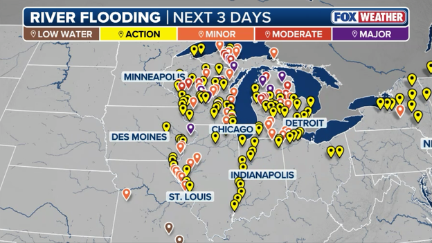
Major flooding is expected on some Midwest rivers and streams as heavy rain hammers the region this week.
Flood Watches remain in effect across northern Michigan through Wednesday morning. However, the danger likely won't end then; with high soil saturation levels across the Plains and another round of rain expected later this week, officials warn that flash flooding risks could be prolonged well into the weekend.
Residents in these flood-prone areas should monitor river gauges closely and never attempt to drive through flooded roadways.
A dangerous situation is unfolding in Waupaca County, where the National Weather Service has issued a Flash Flood Warning due to the imminent failure of the Big Falls Dam.
Law enforcement has reported that the dam is on the verge of breaching following several rounds of heavy thunderstorms that have dumped 2 to 5 inches of rain across the region.
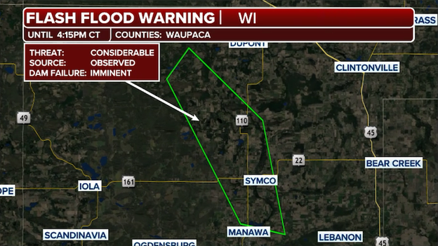
A Flash Flood Warning has been issued for the Little Wolf River due to an imminent dam failure.
We're told a failure would trigger catastrophic flash flooding along the Little Wolf River, sending a wall of water downstream toward the village of Big Falls.
Residents in low-lying areas below the dam must move to higher ground immediately. The wall of water from a breach could arrive with little to no warning, turning local roads into impassable rivers and threatening structures in its path.
Emergency crews are on high alert, and officials are urging everyone in the impacted zone to avoid all travel as "Turn Around, Don't Drown" remains the rule of the morning.

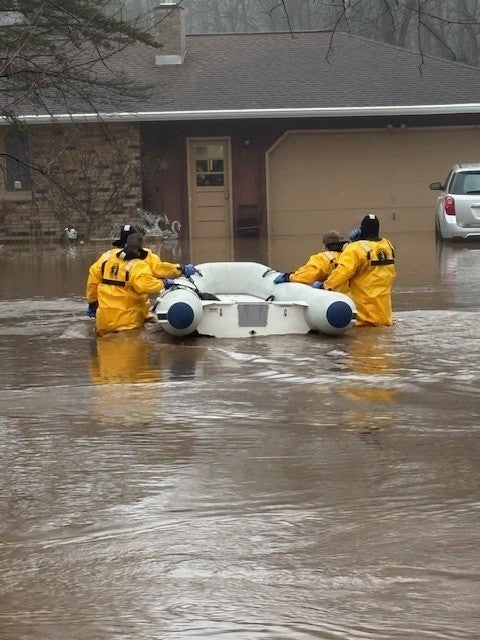
(Suamico Fire Department/Facebook)
Firefighters in Suamico, Wisconsin, carried out a harrowing rescue on Tuesday morning as torrential rains caused floodwaters to inundate a local residence.
Crews arriving at the home on Stream Road found the basement completely submerged and water beginning to spill onto the first floor, trapping three people inside.
Firefighters were able to successfully evacuate all three occupants before the situation turned even more dire, securing the area as the region remains under a significant threat for more heavy rain and flash flooding throughout the day.
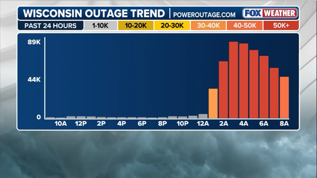
Latest power outage tracker for Wisconsin (PowerOutage.com)
Wisconsin utility crews have made significant progress this morning, cutting the number of outages in half as they race to restore power before a second, more powerful round of storms arrives.
While over 85,000 Wisconsin residents were in the dark at the peak of the overnight damage, that number is steadily falling as teams clear downed trees and repair lines snapped by last night's intense winds.
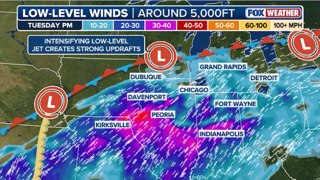
Low-level wind shear will increase this afternoon and evening, which will help fuel the development of supercell thunderstorms in the Midwest.
The FOX Forecast Center is monitoring a strengthening low-level jet that is expected to ramp up significantly by late Tuesday afternoon.
These intensifying winds, just a few thousand feet above the surface, will provide the crucial speed shear and directional shear necessary to tilt and rotate rising air columns.
This atmospheric twisting is the key ingredient that allows standard thunderstorms to organize into rotating supercells, significantly increasing the risk for both giant hail and tornadic activity as the storms tap into this increasing energy.
Today's severe weather threat has increased, with the chance of intense tornadoes likely in the Midwest. A chance of an EF-3 tornado is likely for parts of Wisconsin, Iowa and Illinois.
Weather Command meteorologists Stephen Morgan and Marissa Torres break down the changing threat.
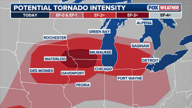
The Storm Prediction Center is concerned about the the threat for intense (EF-3+) tornadoes across parts of the Midwest later today.
The greatest potential for intense tornadoes today is concentrated along a corridor stretching across eastern Iowa, northern Illinois, and southern Wisconsin.
Forecasters are particularly concerned about a warm front where low-level wind shear is expected to maximize late this afternoon.
Any discrete supercell storms that can develop along this boundary will have the best chance of producing intense, long-track tornadoes (EF-3 or higher).
As the evening progresses, this threat will likely transition into a damaging wind event as storms congeal into a fast-moving line across the Great Lakes.
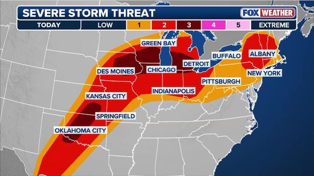
The Storm Prediction Center (SPC) has significantly upped the ante this morning, expanding the Level 3 Enhanced Risk zone deeper into the Great Lakes region.
This expansion reflects growing confidence in a volatile atmospheric setup where record-breaking warmth and high dew points are pooling ahead of a strengthening surface low.
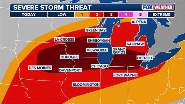
The Storm Prediction Center has just expanded the Level 3 of 5 severe weather threat zone for today.
The core threat area now more broadly encompasses eastern Iowa, southern Wisconsin, northern Illinois, southern Michigan, and western Oklahoma putting major population centers on high alert for an outbreak of intense supercells capable of producing intense tornadoes (EF-3 or stronger) and hail larger than 2 inches in diameter.
Forecasters noted that the shift of a warm front has opened the door for these dangerous storms to track further into the Great Lakes than initially anticipated.
This storm fuel is peaking just as wind shear increases this afternoon, creating a window for discrete, long-track storms before they likely congeal into a damaging wind threat after sunset.

If you are in the path of this expanded risk zone, now is the time to review your severe weather plan, as the ceiling for storm intensity has clearly been raised.
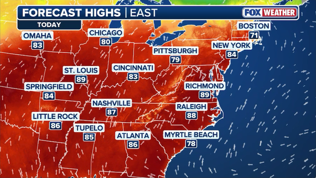
Forecast high temperatures for Tuesday across the eastern half of the United States.
Record-breaking spring warmth is acting as high-octane storm fuel for today’s severe weather, with temperatures soaring as much as 20 to 30 degrees above average across the Midwest.
This unseasonable heat is rapidly increasing atmospheric instability, or CAPE (Convective Available Potential Energy), creating a volatile environment where air can rise explosively into the upper atmosphere.
When this intense surface heat clashes with an approaching cold front and a powerful jet stream, it provides the raw energy needed to sustain long-track supercells and high-intensity tornadoes.
More than 50,000 customers across Southeast Wisconsin are starting their Tuesday in the dark after powerful overnight storms tore through the region.
According to We Energies, the hardest-hit areas include Milwaukee and Waukesha counties, where intense winds and storm rotation downed trees and snapped power lines. Utility crews are working to restore service as quickly as possible, but with another significant round of severe weather forecast for this afternoon, officials are warning that additional outages are likely.

Latest power outage tracker showing significant outages in Wisconsin. (PowerOutage.com)
The severe weather threat is reaching a fever pitch today as the FOX Forecast Center warns of a massive storm system spanning over 1,500 miles and impacting more than 15 states.
A dangerous Level 3 out of 5 risk is centered over eastern Iowa, northern Illinois, and southern Wisconsin, where the atmosphere is primed for an outbreak of powerful supercells.
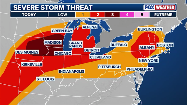
Severe thunderstorms are expected to erupt across 15 states from the Midwest to the Northeast with tornadoes, damaging hail, and dangerous winds.
With dew points climbing into the 60s and intense daytime heating providing ample storm fuel, residents in major hubs like Chicago, Des Moines, and Milwaukee should prepare for a volatile afternoon and evening.
The first wave of activity is expected to ignite around 3:00 p.m. CT along a warm front draped across the Midwest. While the initial threat focuses on destructive hail measuring 2 to 3 inches in diameter, the danger will shift as sunset approaches.
Strengthening winds aloft are expected to increase low-level spin, significantly raising the potential for strong, long-track tornadoes (EF-2 or higher). This risk is particularly high for any discrete storm cells that can remain south of the front, though a transition into a fast-moving line of damaging wind remains a threat through the overnight hours.
The reach of this system extends far beyond the Midwest, stretching from the southern Plains all the way to the Northeast:
- Southern Plains: Intense heating along the dryline will likely trigger supercells across Texas, Oklahoma, and Kansas by mid-afternoon. These storms will be capable of producing massive hail up to 3 inches and isolated tornadoes.
- The Northeast: A separate round of thunderstorms will race across Pennsylvania, upstate New York, and New England. The primary concern here is damaging wind gusts reaching 60 mph, which could impact the I-95 corridor and cities like Syracuse late this evening.
- Looking ahead: The active pattern won't break tonight, as a few more severe storms are forecast to redevelop across the Plains on Wednesday.
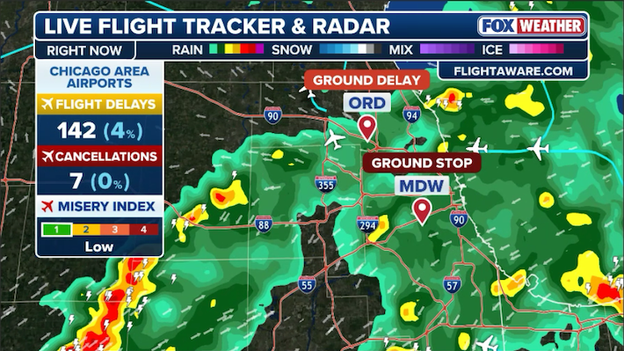
Storms have triggered significant flight delays at Chicago's Midway and O'Hare airports this morning.
Travelers at O'Hare and Midway international airports are facing a grueling start to the morning as a line of powerful storms tracking through Chicagoland has triggered ground stops and extensive ground delay programs.
The Federal Aviation Administration (FAA) issued the halts as lightning and downpours moved over the terminals, leading to a cascade of cancellations and soaring departure delays that are expected to ripple through the flight schedule all day.
If you are heading to either airport, officials are urging you to check your flight status before leaving home while the region remains under the gun for severe weather.
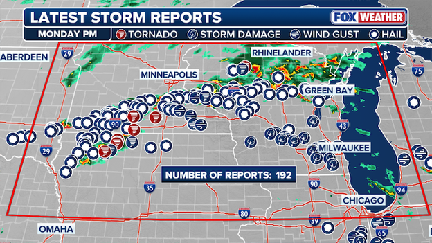
Severe weather storm reports from Monday, April 13.
Monday night’s severe weather served as a violent opening act for the multi-day storm threat currently gripping the central U.S.
A total of at least 14 preliminary tornado reports were logged across four states, with the most significant damage occurring in Ottawa, Kansas, where homes were battered, power poles were snapped, and thousands were left without electricity.
The storms developed as powerful supercells along a warm front, dropping tennis-ball-sized hail in parts of Minnesota and confirmed tornadoes in rural areas of northwestern Iowa and southern Wisconsin.
The damage was widespread as the system tracked northeast through the overnight hours, impacting communities from the central Plains into the Upper Midwest.
A tornado injured 2 people and destroyed homes and businesses after ripping through part of Hillsdale, Kansas.
National Weather Service survey teams are deploying this morning to assess the intensity of the damage and confirm tornado ratings.
These initial storms have primed the atmosphere for today’s even larger threat, leaving many residents across the Midwest on high alert for a second consecutive round of dangerous weather.
You’ve reached the beginning of this live coverage.