Live updates: Polar Vortex collapses as snow and ice threaten millions in the Midwest, Northeast
Live updates: Polar Vortex collapses as snow and ice threaten millions in the Midwest, Northeast
Download the AppWhat to know at this hour
View postCoverage for this event has ended.
A recent survey released by the National Weather Service confirmed an EF-0 tornado in Trussville, Alabama on Thursday.
According to the NWS, tornado path was 1.63 miles long with max winds were estimated at 85 mph.
Additionally, the National Weather Service confirmed that there was a microburst near Pinson, packing dangerous straight-line winds estimated between 70–75 mph that downed trees and caused damage in a residential neighborhood.
As millions in Massachusetts continue to dig out from the historic nor'easter, one local shelter went above and beyond to protect at-risk animals.
A Sudden Stratospheric Warming Event is expected to split the Polar Vortex next week, which could mean big changes for America's long-awaited spring warmup.
- Complex winter storm incoming: A multi-day winter threat is developing over the Northern High Plains and is expected to bring plowable snow and ice to the Mid-Mississippi Valley, Ohio Valley, and Mid-Atlantic starting Sunday.
- Historic Texas heat: While the Northeast cleans up from a recent blizzard, temperatures in the Rio Grande Valley soared above 100°F on Thursday, marking the first triple-digit readings in the U.S. for 2026.
- Florida fire relief: A cold front will sweep through the Sunshine State this weekend bringing some much-needed rain to the state as it endures 'extreme' drought conditions and dangerous fire weather conditions.
- The Polar Vortex paradox: A rare Sudden Stratospheric Warming Event is expected to the Polar Vortex to weaken and split into two. This sounds cold, but the current alignment is actually creating a high-pressure ridge that will act as a "shield," likely bringing a spring-like surge of mild temperatures to the Lower 48 through early March.
- Severe storm threat surging: As March begins, the threat for severe weather, including tornadoes, is expected to crank up across America's Heartland.
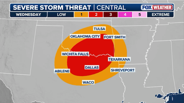
Severe storms are expected to erupt across Oklahoma and Texas on Wednesday.
The FOX Forecast Center is closely monitoring a developing weather setup that could bring a significant round of severe thunderstorms to the Central and Southern Plains next Wednesday.
After a period of record-breaking warmth, a powerful storm system is expected to collide with moisture surging north from the Gulf of America, creating a volatile environment for storm development.
While the exact timing and placement of the strongest storms are still being refined, the primary concerns for Oklahoma and Texas include damaging winds, huge hail, and even a few tornadoes.
FOX Weather meteorologists says this threat emerges from a larger pattern change across America. That change will result in more periods of stormy weather across the U.S. with additional opportunities for severe storms in the opening days of March.

Courtesy: NASA/Jim Ross/NASA
In a move that mirrors the cautious, step-by-step approach of the 1960s, NASA has officially announced a radical shift for the Artemis III mission. Originally billed as the historic return of humans to the lunar surface, the mission will no longer attempt a landing.
Instead, Artemis III is being re-profiled as a Low Earth Orbit (LEO) mission, slated for no earlier than 2027.
Space enthusiasts will recognize this strategy. Just as Apollo 9 stayed in Earth orbit to test the Lunar Module’s systems before Apollo 11 made history, Artemis III will now serve as a critical dress rehearsal.
With Artemis III staying close to home, the mantle of the first landing now passes to Artemis IV.
New NASA Administrator Jared Isaacman has outlined an aggressive new timeline to keep the program’s momentum:
- Artemis IV (2028): Now designated as the first crewed landing mission.
- Rapid turnaround: NASA is pivoting from 3-year SLS production cycles to a targeted 10-month turnaround.
- Double the chances: The goal is to facilitate up to two landing attempts in 2028, ensuring that if the first attempt faces a scrub or technical delay, the second "bullet" is ready to fly shortly after.

The decision comes after growing concerns regarding the "stacking of firsts." Combining the first crewed flight of the HLS, the first massive orbital propellant transfer, and the first landing at the lunar South Pole into a single mission was increasingly viewed as a high-risk gamble.
By de-risking the landing and focusing on the hardware in LEO, NASA is betting that a slight delay today will ensure a more sustainable and safer presence on the Moon tomorrow.
Avalanche experts warn that backcountry conditions in the mountains of Colorado remain dangerous.
Avalanche danger is currently rated as "considerable" and "moderate," but Colorado Avalanche Information Center (CAIC) experts warn that these labels can be deceiving—the potential for a large, unsurvivable avalanche remains very real.
Right now, experts are concerned about a persistent slab problem, which is a dangerous layer of buried, weak snow that can stay unstable for weeks and may only collapse after several people have already crossed the slope.
The dire consequences remain: you can still trigger an unsurvivable, large to very large avalanche.
The most critical conditions are centered in the Northern Mountains, specifically from the Never Summer Mountains south through Berthoud and Loveland passes into Summit County and the Gore Range.
These areas were recently hammered by dense, heavy snow that added significant weight to an already fragile snowpack.
A bullseye for danger was identified on Thursday when a large persistent slab avalanche was human-triggered in the Nitro Chutes on Berthoud Pass—an area expected to see high traffic this weekend.
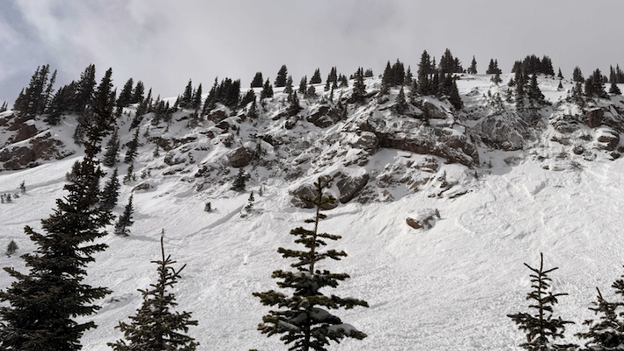
An avalanche in Nitro Chutes on Berthoud Pass on Thursday. (Courtesy: Colorado Avalanche Information Center on Facebook)
To stay safe, follow these essential guidelines from the CAIC:
- Avoid steep slopes: Stay off and out from under any slopes steeper than 30 degrees on north and eastern aspects.
- Watch for "Scary Moderate": Don't be fooled by a lack of obvious red flags like cracking or booming; the consequences of a slide remain just as high.
- Be cautious in the Elks: A similar dangerous setup exists in the Elk Mountains near Aspen, as evidenced by a large natural avalanche that ran on Garrett Peak earlier this week.
- Check on conditions: Always visit colorado.gov/avalanche for the most up-to-date forecast before you step into the backcountry.
A search and rescue operation in the Town of North Hudson, New York ended successfully Thursday afternoon after a 58-year-old hiker from Mechanicville went missing in the treacherous Dix Range.
The alarm was raised at 8:45 p.m. on Wednesday when the hiker's spouse reported them overdue from a planned two-day trek. The hiker’s last contact had been early that morning, stating they were roughly six miles from their destination but were "tired and moving slowly."
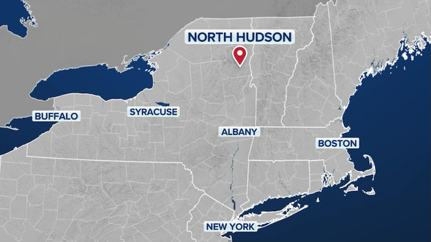
A search and rescue operation in the Town of North Hudson, New York ended successfully Thursday afternoon.
The search intensified throughout the night and into Thursday as Forest Rangers located the hiker’s vehicle at the Elk Lake trailhead at 9:50 p.m. Wednesday night. Seven Rangers then searched the rugged terrain through the night with no immediate results.
By Thursday morning, more than 20 Rangers joined the effort, supported by New York State Police Aviation, which used helicopters to insert teams into high elevations and conduct aerial sweeps.
Shortly before 3 p.m. ET on Thursday, a search crew finally located the hiker off the Lillian Brook trail.
Upon discovery, the hiker was found to be suffering from mild hypothermia and frostbite. The individual was treated for these cold-weather injuries following their extraction from the wilderness.
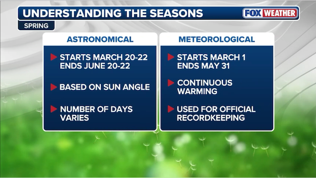
March 1 marks the start of meteorological spring across America.
While many people are waiting for late March to break out the gardening tools, for the weather world, the finish line for winter is already here.
Sunday marks the official start of meteorological spring. Meteorologists and climatologists break the seasons into groups of three full months based on the annual temperature cycle rather than the position of the Earth relative to the sun.
Meteorological spring consists of the months of March, April, and May. Using full months makes it much easier to calculate seasonal statistics and compare weather patterns year-over-year.
Astronomical spring—the one marked by the vernal equinox—doesn't arrive until Friday, March 20.
While the current weather map may look relatively calm, the FOX Forecast Center is tracking a major pattern shift that could launch an extended period of severe weather starting the middle of next week.
This transition is driven by a "flip" in the atmosphere: persistent ridging in the East is expected to give way to an upper-level trough digging into the West. An upper-level trough is an elongated area of low atmospheric pressure that often serves as the engine for storm development.
As this trough establishes itself, it will draw a steady stream of moisture northward from the Gulf of America, with dew points, the temperature at which air becomes saturated with water vapor, expected to climb above 60°F across the eastern half of the country. This surge of moisture is the "fuel" needed for robust, severe thunderstorms.
A combination of upper-level energy and eastern moisture creates a storm track right through the heart of the U.S., potentially leading to nearly daily rounds of storms.

Severe storms are expected to threaten America's Heartland in the first couple weeks of March.
Right now, the FOX Forecast Center says the setup is primed to deliver multiple rounds of damaging winds, large hail, and tornadoes to several key regions throughout the first half of March:
- South Plains & Southeast: States from Texas and Oklahoma through the deep South are in the primary path of these disturbances.
- Ohio Valley: Milder temperatures and surging moisture could push the severe storm threat as far north as the Lower Ohio Valley.
- Flood potential: Because this pattern may stall, producing 7 to 10 days of consistent rain, the risk of flash flooding is increasing for the Mississippi and Tennessee Valleys.
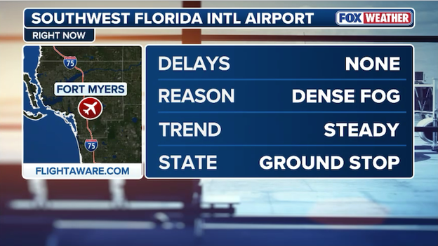
Fort Myers' Southwest Florida International Airport is under a ground stop until 9:30 a.m. ET.
Travelers headed to Florida are facing a foggy start to their travel plans this morning.
Right now, a ground stop is in effect for Southwest Florida International Airport (RSW) until 9:30 a.m. ET. A ground stop is a measure used by air traffic control to keep planes at their departure airports when conditions—such as low visibility—make it unsafe to land at their destination.
The National Weather Service has issued a Dense Fog Advisory for much of West Central and Southwest Florida this morning, including Lee, Charlotte, and Collier counties. The thick, soupy haze has reduced visibility to less than a quarter mile in many locations, making for a tense morning for both commuters and air travelers.
In some areas, the fog is being compounded by smoke from the National Fire burning in the Big Cypress National Preserve, creating a dangerous mixture known as "super fog" that can drop visibility to nearly zero.
Other airports are facing fog problems this morning with flights in and out of Orlando International Airport subject to delays as visibility drops over the airfield.
Video shows a tornado struck Jefferson County, Alabama, on Thursday afternoon, leaving a path of destruction through the Pinson and Trussville areas.
Local fire departments and emergency management reported that more than a dozen homes were damaged, with some residents displaced and power lines downed across major roadways.
National Weather Service teams are expected to survey the area today to officially determine the tornado's strength and final path length.
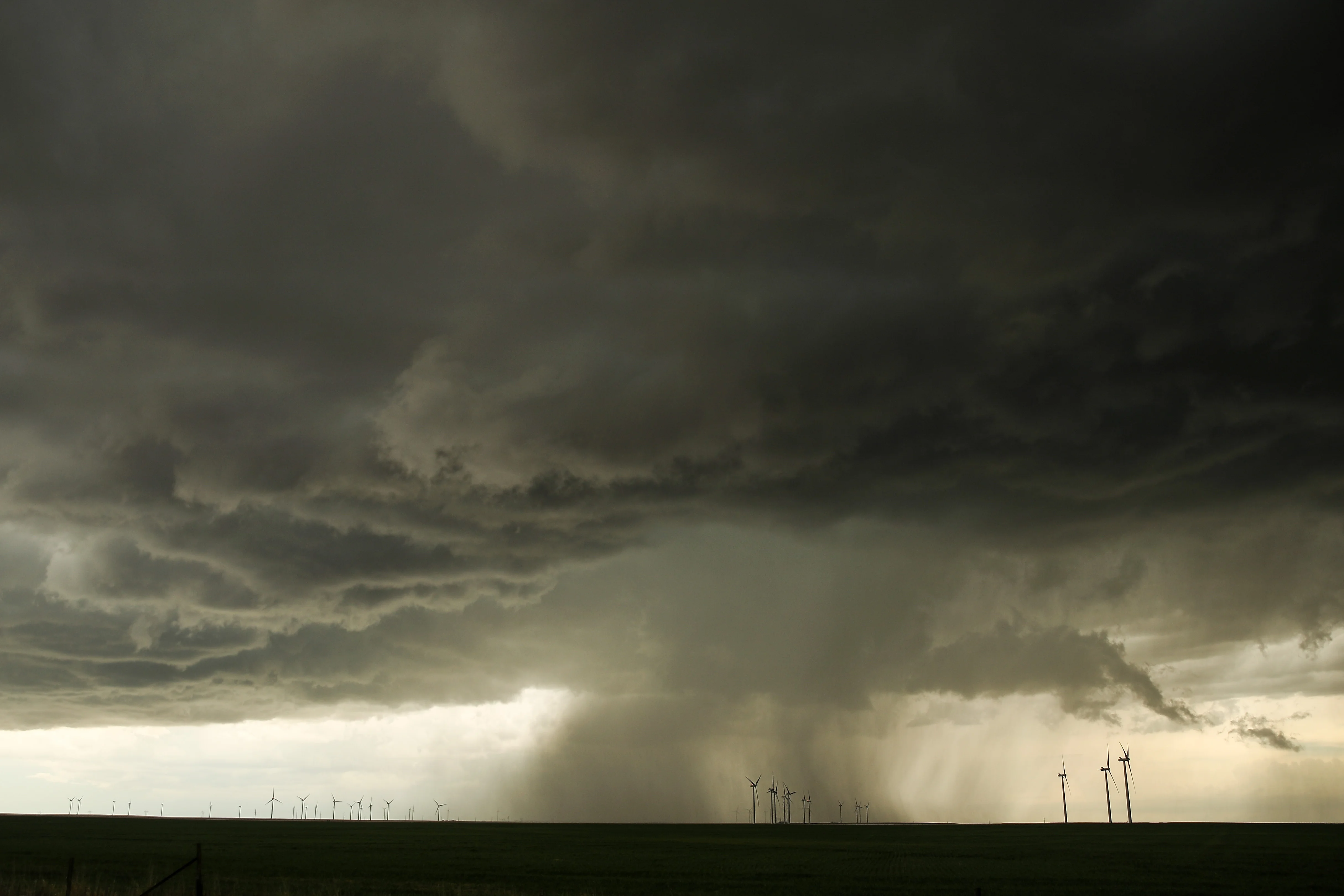
Severe thunderstorms tore across Alabama on Thursday, leaving a trail of significant hail damage and structural destruction in their wake.
While the focus was on a confirmed tornado that struck the Pinson and Trussville areas in Jefferson County, much of the state's northern and central regions were battered by huge hailstones as large as eggs.
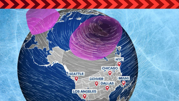
When you think of the Polar Vortex, your mind likely goes straight to bone-chilling Arctic outbreaks. However, a rare atmospheric phenomenon is currently unfolding that may actually lead to a surprising spring-like surge for millions.
The FOX Forecast Center is monitoring a major Sudden Stratospheric Warming Event (SSWE)—a rapid spike in temperature miles above the Earth's surface—that is causing the Polar Vortex to collapse and split into two distinct lobes.
A Sudden Stratospheric Warming Event occurs when temperatures in the stratosphere, roughly 6 to 50 miles up, jump by more than 50°F in just a few days, disrupting the typical circulation of cold air.
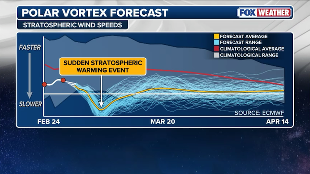
Computer forecast models show a Sudden Stratospheric Warming Event
Remarkably, this is the second time this season such an event has occurred. Since major warming events typically only happen once every other year, witnessing two in a single winter is a once-in-a-decade rarity.
While a split vortex usually signals a southward spill of Arctic air, the current positioning is playing a different hand.
Long-range modeling for the first half of March shows the core of the coldest air remaining anchored over Canada and Alaska. This specific alignment is expected to build a massive high-pressure ridge over the Lower 48. A high-pressure ridge is an elongated area of relatively high atmospheric pressure that typically brings stable, clear, and warmer conditions.
In a paradoxical twist, the shattered Polar Vortex is currently acting as a shield against winter's return rather than a gateway for it.
NOAA's Climate Prediction Center is leaning into this signal, showing a high probability of above-average temperatures for the entire Lower 48 during the second week of March.
However, don't pack away the winter coats just yet. There is a notorious lag time with these stratospheric events; it can take four to six weeks for the changes in the upper atmosphere to fully "sink" down to the surface.
This means that while early March looks exceptionally mild, the delayed effects could potentially trigger a late-season cold snap as we head into April.
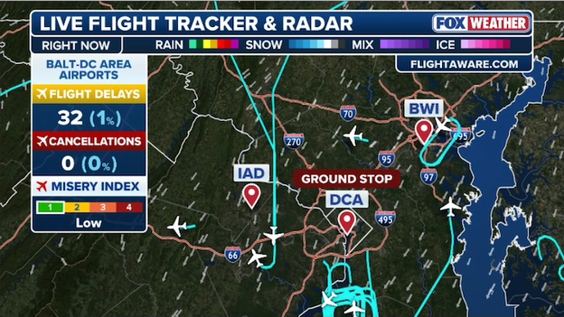
A ground stop was ordered by the FAA for Washington National Airport until 9 a.m. ET Friday.
Travelers at Ronald Reagan National Airport (DCA) are facing a slow start this morning after a ground stop was issued due to dangerously low visibility.
A ground stop is a traffic management measure where flights destined for a specific airport are held at their departure point to manage a safety or capacity issue—in this case, thick fog that has settled over the Potomac.
The Federal Aviation Administration (FAA) issued the stop as visibility occasionally dropped to 1/4 mile or less. This locally dense fog is the result of moistened low-level air and calm winds, creating a damp chill across the D.C. metro area.
While the ground stop is currently scheduled to lift around 9 a.m. ET, residual delays are expected to ripple throughout the morning as the airport works to clear the backlog of flights.
If you are heading to the airport or picking someone up, be sure to check your flight status and allow extra time to get there.
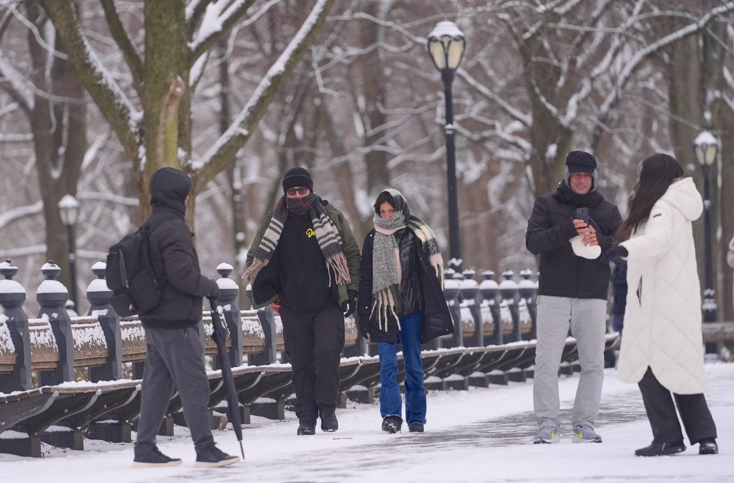
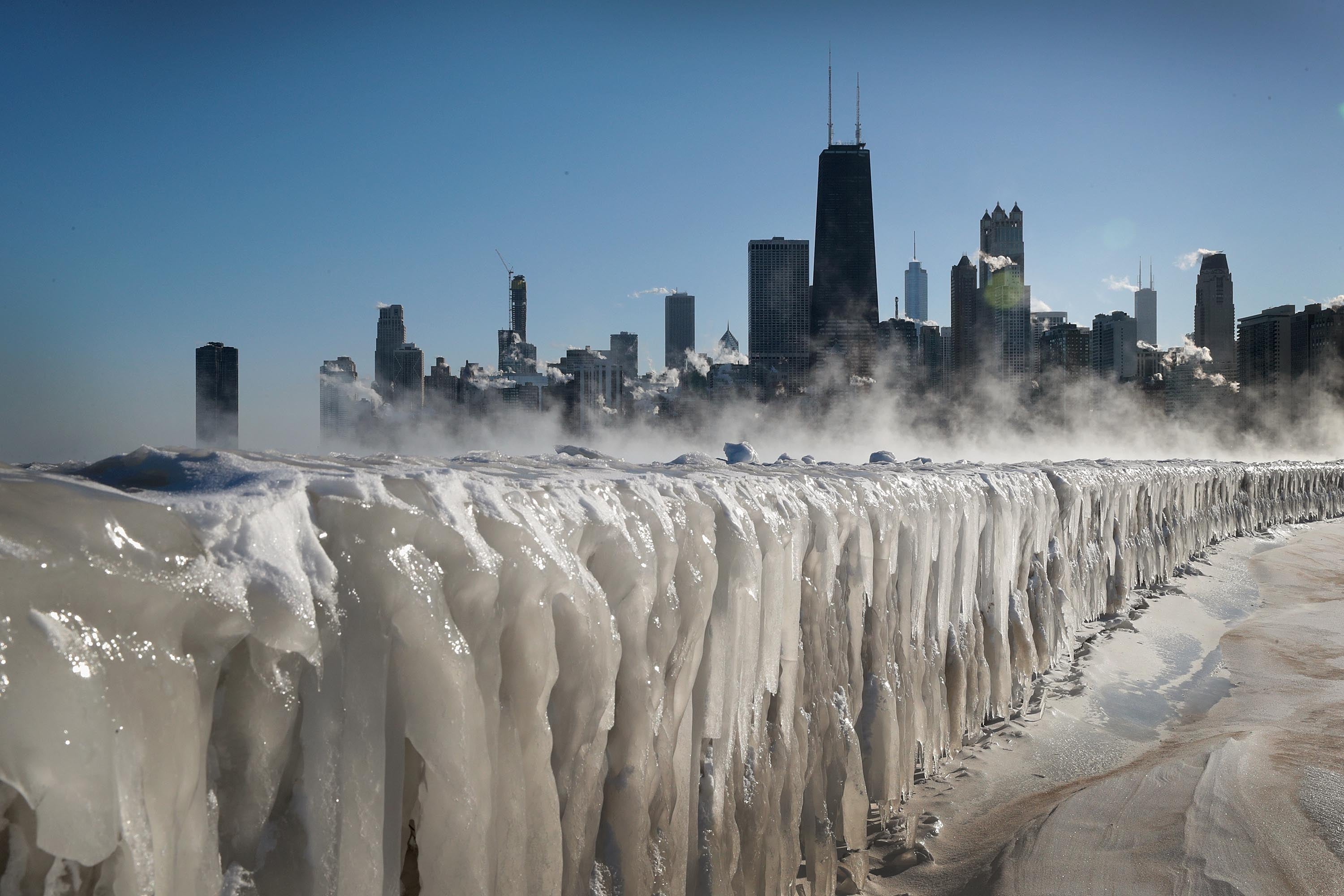
As the Northeast continues to dig out from the historic Blizzard of 2026, the FOX Forecast Center is monitoring three distinct waves of wintry weather that could slow recovery efforts.
While rumors on social media suggest another massive event, FOX Weather is actually expecting light-to-moderate snow and some ice rather than another blockbuster event.
Altogether, this evolving system could impact more than two dozen states from the Plains to the Atlantic coast.
The first round begins Saturday in the Midwest, reaching the Northeast early Sunday with an inch or two of snow for most.
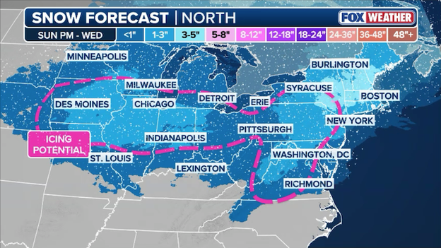
Three rounds of wintry weather will drop light-to-moderate snow from the Midwest to the Northeast through Wednesday.
While cities like Milwaukee, New York, and Boston will see light accumulations, the bigger story may be the dramatic temperature drop; highs near 50°F on Saturday will plummet over 20°F by Sunday, leaving the I-95 corridor with single-digit wind chills by Monday morning.
The second and third waves, spanning Sunday through Wednesday, will focus on the Mid-Atlantic and Northeast through a process called overrunning. Overrunning occurs when warm, moist air is forced to climb up and over a dense dome of cold air stuck at the surface, often creating a messy mix of precipitation.
While the exact snow totals depend on the depth of that cold air, the FOX Forecast Center says high-end scenarios suggest a 3-to-5-inch swath of snow for cities like Chicago, Detroit, and Philadelphia.
Freezing rain and icing is also a concern for Tuesday, particularly across the valleys of Pennsylvania where freezing air stays trapped.
Don't miss out on the big weather news making headlines in America. You can go back and see how the forecast has evolved with our LIVE updates from Thursday.
You’ve reached the beginning of this live coverage.