Live updates: Messy mix of snow and ice target the Northeast, spring heat to trigger severe storms
Live updates: Messy mix of snow and ice target the Northeast, spring heat to trigger severe storms
Download the AppWhat to know at this hour
View postCoverage for this event has ended.
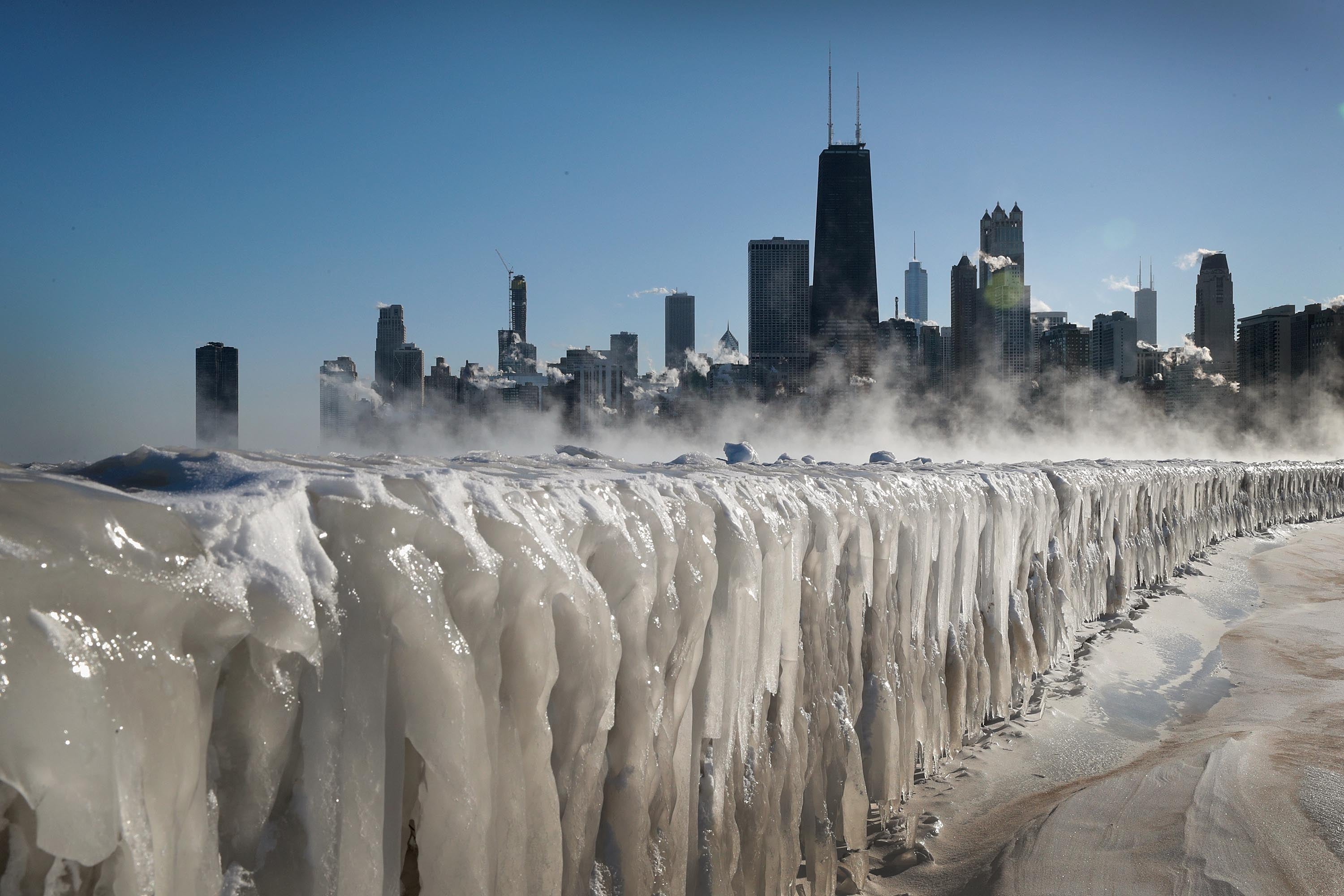
Wild weather will hit America this week with snow, ice, and tornadoes all possible as spring kicks off.
- New winter weather threat: A complex, multi-day system is tracking from the Midwest to the Mid-Atlantic, bringing snow and dangerous ice to millions.
- Record-breaking sizzle: Temperatures in the South are expected to surge to record highs through the week, setting the stage for violent storms to erupt.
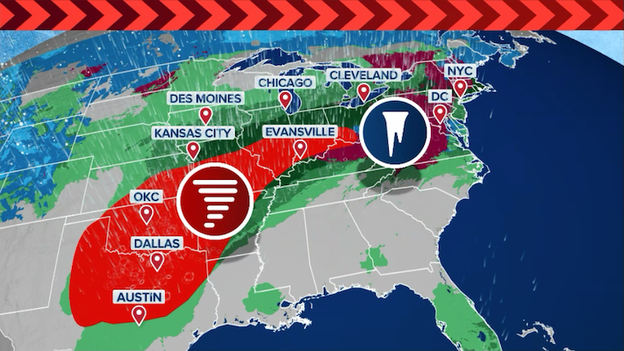
- Severe storm risk: Dangerous thunderstorms will erupt across the Plains states this week, spawning tornadoes, destructive winds, and damaging hail as spring severe weather season kicks off.
- Total lunar eclipse: A "Blood Moon" will be visible across America early Tuesday morning, with totality beginning at 6:04 a.m. ET.
- Weather whiplash: From the 20s to the 60s, millions in the Northeast and Mid-Atlantic will feel the spring heat later this week as a major warmup hits the East.
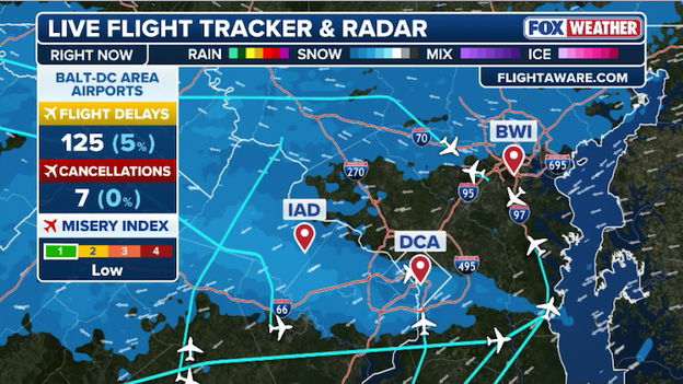
More than 100 flights have been delayed in Washington and Baltimore so far today.
Wintry weather is officially knocking on the door of the nation's capital, and if you have plans to fly out of Ronald Reagan Washington National Airport (DCA) this evening, you'll want to keep a close eye on the departure board.
Several flights are already experiencing gate holds and taxi delays. While many delays are currently clocked at 15 minutes or less, the incoming snow is expected to tighten the squeeze on terminal operations.
The Federal Aviation Administration (FAA) says it may implement a ground stop later today as snow rolls in. A ground stop is used to limit the number of planes arriving to an airport by holding them at their departure point until the ground stop is lifted.
Flights destined to DCA may face additional delays or cancellations this evening as the wintry weather limits runway operations.
Set your alarms for tomorrow morning! A spectacular Total Lunar Eclipse is set to sweep across the sky on Tuesday. This rare "Blood Moon" will be the last of its kind until late 2028, making it a must-see event for early risers and night owls alike.
What Is a Blood Moon?
A total lunar eclipse occurs when the Earth passes directly between the Sun and the Moon, casting its deep shadow (the umbra) across the lunar surface.
The Moon doesn’t go dark; instead, it turns a ghostly, coppery red. This happens because Earth’s atmosphere bends sunlight, filtering out blue light and projecting the red-orange glow of every sunrise and sunset on Earth onto the Moon at once.
When and how to watch
Unlike solar eclipses, you don’t need special glasses or equipment to enjoy this show—it is perfectly safe to view with the naked eye.
For those of us in the Eastern Time Zone, the timing is a bit of a race against the sunrise:
- Partial eclipse begins: 4:50 a.m. ET
- Totality (The "Blood Moon" phase) starts: 6:04 a.m. ET
Why this one is so special
- The "Impossible" Selenelion: Some observers may witness a rare atmospheric illusion where the eclipsed Moon and the rising Sun are visible in the sky at the exact same time.
- The Long Wait: After tomorrow, the next total lunar eclipse won't occur until New Year’s Eve 2028.
- Celestial Pairing: Look slightly above the Moon during the eclipse to spot Jupiter, which will be shining brightly nearby, adding a brilliant companion to the red-tinted Moon.
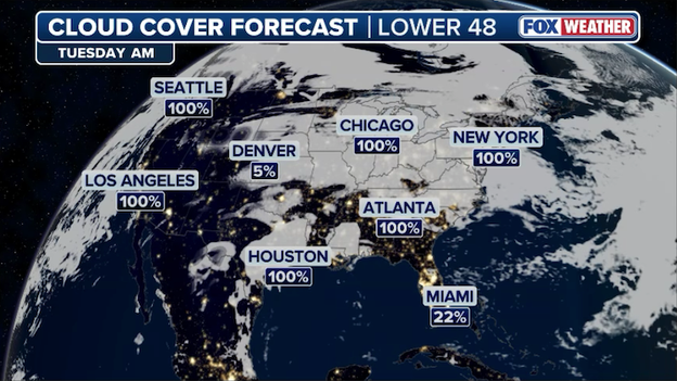
Clouds are expected to obscure Tuesday morning's Total Lunar Eclipse in major cities across America.
Where to see it on Tuesday
The FOX Forecast Center is tracking where clouds may obscure your view on Tuesday morning. Right now, widespread dense clouds are expected in the Northeast, Mid-Atlantic, and Midwest, which could prevent millions from seeing the spectacle.
Better viewing conditions are anticipated across Florida and portions of the West.
Spring on hold? Warmup canceled? With the Polar Vortex fracturing and splitting apart over the North Pole, there are a lot of questions about how America's weather will play out in the weeks ahead.
Right now, a Sudden Stratospheric Warming event (SSWE) has caused the Arctic’s "containment field" to collapse, shifting fragments of freezing air around the Northern Hemisphere. Instead of a stable, spinning circle over the Pole, the vortex has split into two distinct cores.
Surprisingly, this will set the stage for a massive warmup across America this week. Temperatures are predicted to surge into the 60s, 70s, and 80s across the East as a ridge of high pressure expands over the United States--a huge warmup that could last through mid-March.
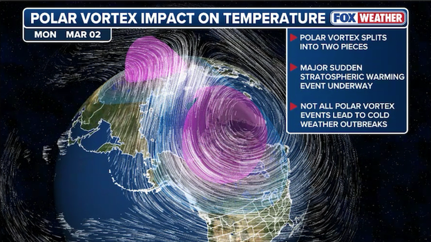
While the Polar Vortex splits up above the North Pole, America is on track for a huge spring warmup this week.
The FOX Forecast Center says the coldest air is getting bottled up in Canada for now, but that could change come later this month into April.
This atmospheric breakup often acts as winter’s parting gift, creating a volatile clash between Arctic air and early-spring warmth.
It typically takes 4-6 weeks for big temperature changes to occur following a SSWE, so we aren't out of the woods yet; keep the parkas accessible, as this fragmented vortex is expected to send another glancing blow of cold air toward the U.S. just as millions finally enjoy a reprieve from this brutal winter.
While early March in New York is looking exceptionally mild, the FOX Forecast Center warns against packing away your winter gear just yet.
A rare atmospheric phenomenon is currently unfolding: the Polar Vortex has undergone a major Sudden Stratospheric Warming Event (SSWE), causing it to weaken and split into two distinct lobes. A Sudden Stratospheric Warming Event is a rapid spike in temperature miles above the Earth's surface that can disrupt the stable flow of cold air usually trapped at the poles.
Remarkably, this is the second time this season such an event has occurred, a rarity that typically only happens once every other year.
But in a paradoxical twist, the shattered vortex is currently acting as a shield for the Lower 48, locking the coldest Arctic air over Canada and Alaska while allowing a massive high-pressure ridge to build over the United States.
This specific alignment is the engine behind the spring-like surge expected for millions across the country through the second week of March.
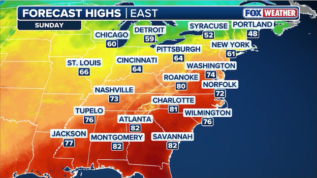
Temperatures are predicted to soar into the 60s and 70s across the eastern half of the U.S. later this week and this weekend.
Temperatures in New York City and the Tri-State area are expected to soar toward 70°F this weekend and next week.
However, Mother Nature may hit the 'pause' button on spring in the Northeast and Mid-Atlantic come later this month or early April.
Because there's often a significant lag in how SSWE events shift global weather patterns, it's likely that America won't feel its full impact until 4-6 weeks from now.
Because of this delay, the effects of the current split could potentially trigger a late-season cold snap just as we head into April.
While the immediate forecast for New York and the surrounding region looks remarkably spring-like, the bill for this early warmth may come due later this spring.
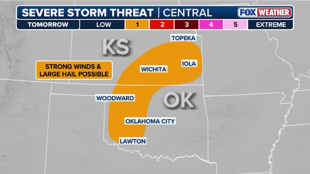
Severe storms could produce damaging hail and powerful winds in the Plains on Tuesday.
March is here and severe weather season is kicking off right on schedule. The FOX Forecast Center is tracking a shift in the weather starting Tuesday as an upper-level disturbance moves across the Desert Southwest and Rockies. As this system advances eastward Tuesday night, a few severe thunderstorms are expected to develop from Kansas to Oklahoma.
These will likely be elevated thunderstorms, which means they form in the higher levels of the atmosphere above a layer of cooler air near the ground. Because of this setup, the primary threat will be damaging hail. An occasional gust to 60 mph may occur within some of the storms, but widespread damaging winds and tornadoes are not expected.
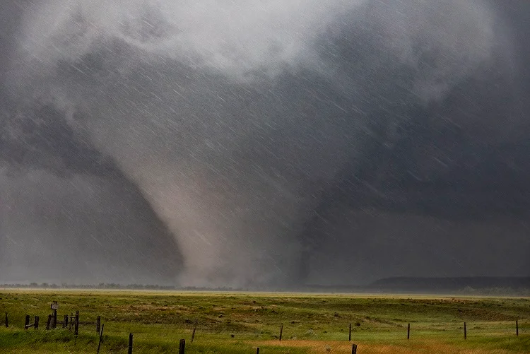
March is a month of transition, often defined by surges of warm air and an increasing risk of severe weather, and this year is proving to be no exception. The FOX Forecast Center is tracking a significant multi-day threat that has prompted the Storm Prediction Center to issue five consecutive days of outlooks starting Tuesday.
The most substantial risk begins Wednesday and persists through the weekend, with the Ark-La-Tex region squarely in the crosshairs. This region—where Arkansas, Louisiana, and Texas meet—is bracing for damaging wind gusts, large hail, and the potential for several tornadoes.
Midweek breakdown
The atmospheric shift begins Tuesday as an upper-level disturbance moves across the Desert Southwest. By Tuesday night, scattered thunderstorms may develop from the Red River into the mid-Mississippi Valley. These are expected to be elevated thunderstorms, which means they form in the atmosphere above a layer of cooler air near the ground. Because of this, the primary concern is large hail, leading to a Level 1 out of 5 risk.
By Wednesday, the threat escalates as warm, humid air surges north. We are closely monitoring higher levels of instability—the fuel that allows air to rise rapidly— and wind shear—changes in wind speed or direction at different heights, which are the essential ingredients for organized severe weather.
Late-week outlook
The severe weather pattern remains locked in through Saturday as the system moves into the mid-Mississippi Valley.
While the threat may be slightly more limited on Thursday, a strengthening jet stream will reinforce the risk by Friday. This high-altitude "river of air" will provide the lift needed to organize storms from Central Texas into the lower Missouri Valley, including cities like Dallas, Oklahoma City, and Kansas City.
By Saturday, a massive upper-level trough over the Western U.S. will reinforce the warm, humid air mass, likely triggering a final round of severe development.
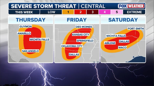
A multi-day severe storm threat is brewing later this week across the Plains states.
While much of the Mid-Atlantic will just see rain on Tuesday, the air will remain cold enough across parts of the Interior Northeast to trigger snow and ice development.
The best chance for accumulating snow will stay north of the I-90 corridor, particularly in Upstate New York, New Hampshire, Vermont, and Maine, where totals could reach 1-3 inches through Wednesday morning.
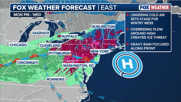
A messy mix of freezing rain, sleet, and snow will hit millions throughout the Northeast on Tuesday.
However, the FOX Forecast Center is most concerned with icing across Pennsylvania and Virginia due to cold air damming. Cold air damming occurs when cold, dense air becomes trapped against the eastern slopes of the mountains, often leading to freezing rain as warmer air flows over the top.
Potential ice totals for this round could reach up to 0.10 inches, and while that doesn't seem like much, it's enough to turn roads into ice rinks.
Major cities along the I-95 corridor will find themselves on the fringe of this system. Boston, New York, and Philadelphia will see a mix of wintry precipitation on Tuesday, but it's not expected to cause widespread travel trouble. Most of the messy mix won't accumulate and should transition to rain through the day.
In the Baltimore and Washington, D.C. metros, rising temperatures will likely prevent any significant accumulation before the event concludes.
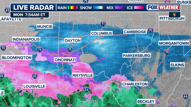
Radar showing a mix of snow, sleet, freezing rain, and rain moving across the Ohio Valley this morning.
A messy band of rain and mixed precipitation is currently pushing eastward across the Ohio and Tennessee Valleys as moisture surges up and over a front draped across the region.
This is known as overrunning--which occurs when warm, moist air is forced to climb over a dense dome of cold air trapped at the surface, creating the perfect environment for snow, sleet, and freezing rain.
Because of this, Winter Weather Advisories are up from Indiana to Pennsylvania, where the snow and sleet could impact travel through tonight.
The threat shifts to dangerous ice accumulations along the Appalachians and Mid-Atlantic, with a Winter Storm Warning specifically issued for the higher elevations of West Virginia. While many areas will see a light glaze, parts of the Virginia and West Virginia Appalachians could see significant icing between 0.1 and 0.3 inches.
Closer to the coast, the Baltimore and Washington metros west of I-95 can expect a coating of ice heading into Tuesday.
You’ve reached the beginning of this live coverage.