Live updates: Life-threatening storms target the Heartland, intense tornadoes and huge hail possible
Live updates: Life-threatening storms target the Heartland, intense tornadoes and huge hail possible
Download the AppCoverage for this event has ended.
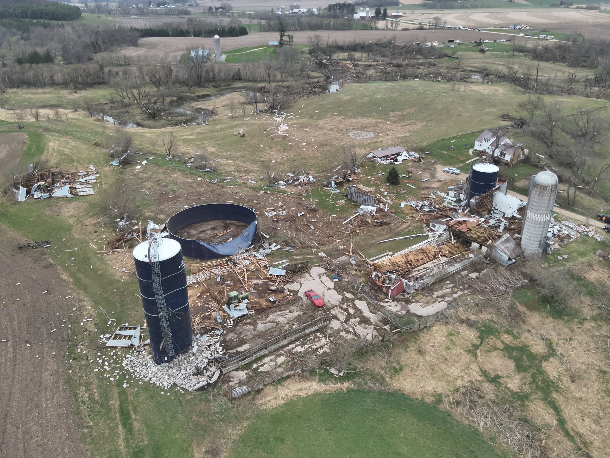
A relentless and far-reaching severe weather outbreak tore across the central United States on Friday, leaving behind a wide swath of damage and millions under threat.
More than 100 tornado warnings were issued as storms carved a destructive path stretching roughly 1,500 miles from the Plains into the Midwest.
Multiple tornadoes were reported, with FOX Weather Storm Trackers intercepting several tornadoes, capturing first-hand looks into the danger and intensity of the tornado outbreak.
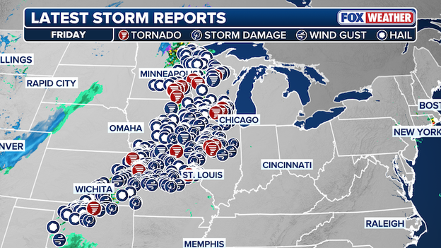
Friday Storm Reports
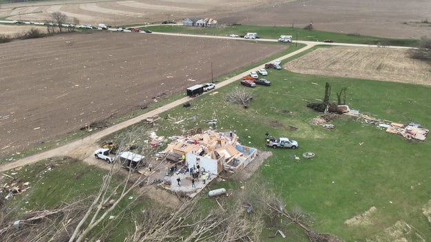
Communities across several states are now assessing damage after powerful winds and possible tornadoes tore apart structures, downed trees and powerlines, and left neighborhoods in disarray.
More than 100,000 customers across the Midwest — including Illinois, Wisconsin and Missouri — remained without power, with additional outages reported in other impacted states after relentless severe storms battered the region.
The storms also triggered widespread power outages, compounding the impact for those in hardest-hit areas.
At the peak of the outbreak, more than 50 million people across 1,500 miles were under the threat of severe weather, as dangerous storms produced large hail, damaging wind gusts and tornadoes throughout the day and into the late evening.
While the most intense activity begins to shift, the threat is not over. Additional rounds of severe weather are expected into Saturday, so stick with FOX Weather for continued coverage and updates as this dynamic and dangerous weather pattern evolves into the weekend.
Severe storms are hammering the Midwest and leaving a growing trail of damage in their wake, knocking out power to more than 100,000 customers across the region, according to PowerOutage.com.
The relentless onslaught of severe weather tore through communities Friday—and the threat is far from over as it pushes into Saturday.
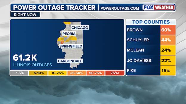
Power Outage Tracker in Illinois.
Illinois is taking the hardest hit, with more than 60,000 customers in the dark. McLean County alone accounts for over 20,000 of those outages, highlighting just how concentrated and intense storm impacts have been in Central Illinois.
Missouri is also reeling, reporting upwards of 35,000 outages scattered statewide as powerful storms continue to strain infrastructure.
In Wisconsin, more than 15,000 customers are without electricity, with several areas reporting significant storm damage after a volatile day of weather.
This is a rapidly evolving situation as dangerous storms continue to track across the region.
Stay with FOX Weather for the latest updates.
Amid a massive, multi-state severe weather outbreak and tornado outbreak that put millions in the path of dangerous storms across a 1,500-mile stretch of the country, Marathon County, Wisconsin, now stands out as one of the hardest-hit areas.
A powerful round of severe weather left a trail of destruction in central Wisconsin Thursday evening, with officials in Marathon County reporting significant damage in the Town of Ringle following what is believed to be a tornado.
According to local authorities, approximately 75 homes sustained damage during the storm.
Courtesy of Marathon County
Emergency crews conducted searches throughout the affected area and confirmed that, despite the widespread destruction, there have been no reported injuries or fatalities. All residents have been accounted for.
Photos released from the scene show extensive structural damage, with homes impacted and debris scattered across neighborhoods.
Officials are now shifting focus toward recovery, while urging the public to avoid the disaster zone. Roads are being kept clear to allow utility crews and emergency responders to move efficiently as they work to restore power and assess damage.
Authorities are also asking people not to bring donations directly to the area at this time, noting that there is currently no infrastructure in place to receive or distribute supplies. Instead, those looking to help are encouraged to wait for further guidance in the coming days.
After a sprawling tornado outbreak and widespread severe weather stretched more than 1,000 miles across the central U.S., the threat is far from over.
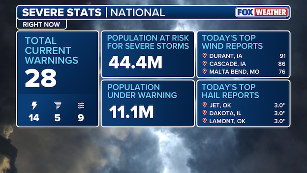
U.S. Severe Stats right now
FOX Weather is continuing wall-to-wall coverage into the night — stay with us as we track the evolving threat and bring you the latest updates on storms and damage across the region.
Amid a widespread severe weather outbreak impacting millions across the central U.S., massive hail is crashing down from the sky as powerful storms sweep through the region, posing a serious threat to anyone and anything in its path and leaving a growing trail of damage.
Baseball-sized hail was reported in parts of Oklahoma, including Jet and Lamont, while communities in Illinois and Wisconsin saw hail up to 2.75 inches in diameter as powerful storms moved through the region.
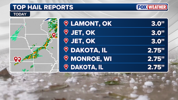
Top Hail Reports
Stay with FOX Weather for the latest on this ongoing severe weather outbreak, including where storms are headed next and what to expect in the hours ahead.
With more than 200 severe weather reports, including at least 20 tornado reports and over 100 tornado warnings, Friday’s ongoing outbreak has unleashed widespread damage across the central U.S.
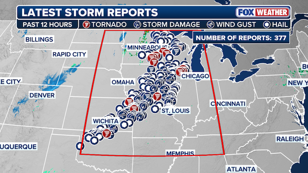
Latest Storm Reports
As the weekend begins, millions across the region have been in the path of dangerous storms stretching from Oklahoma to Wisconsin. Tornadoes, large hail and damaging wind gusts have already carved a trail of destruction — With over 375 storm reports and counting, the threat will linger into the night.
Stay with FOX Weather as we continue to track these severe storms and bring you the latest on the damage and recovery efforts in the hardest-hit communities.
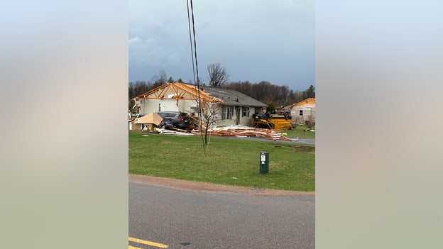
After multiple rounds of severe storms tore through the Village of Lena in northwestern Illinois, Police Chief Brian Lamphere said both the elementary and high schools sustained structural damage.
“Emergency personnel are actively working in areas that were hit hardest, and while the damage is significant in some locations, our focus remains on checking residents, ensuring safety and continuing assessments,” Lamphere said.
The chief also confirmed there were no fatalities in the Village of Lena.
Amid the storm, Stephenson County Sheriff Steve Stovall said on earlier that the Village of Lena is "shut down", and there will be no traffic in or out of the town until further notice.
Aerial images out of Buffalo County, Wisconsin, reveal the scope of destruction left behind after dangerous severe storms swept through the region.
From above, the damage is striking — scattered debris, damaged structures and scarred landscapes underscore the intensity of the storms that moved through.
Courtesy of Buffalo County Wisconsin Sheriff's Office
According to the Buffalo County Sheriff's Office, there we no injuries reported, though State Highway 88 remains closed.
"Cleanup and power restoration efforts are underway with the assistance of several agencies." the Sheriff's Office said.
These scenes come as part of a widespread, ongoing severe weather outbreak stretching across the central U.S., with the Midwest among the hardest-hit regions.
Stay with FOX Weather for the latest updates, live coverage and the most up-to-date forecast as communities begin to assess the damage and start recovery efforts.
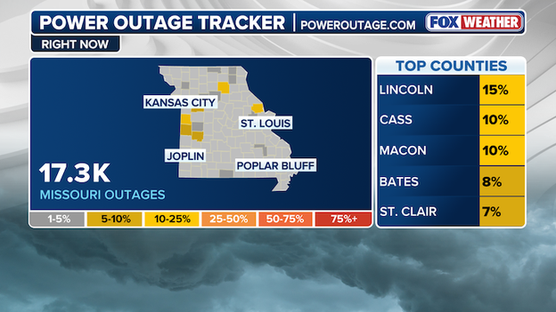
Power outages are surging across the Midwest as a widespread severe weather outbreak continues to impact the region. More than 45,000 customers are without power across Missouri, Illinois and Wisconsin alone, according to data from PowerOutage.com.
Power Outage Tracker using data from poweroutage.com
Missouri is reporting over 17,000 outages, with the hardest-hit areas in Lincoln, Cass and Macon counties.
Illinois has more than 15,000 outages, with the greatest impacts reported in Jo Daviess, Stephenson and Schuyler counties.
In Wisconsin, outages have climbed past 14,000, including more than 2,500 in the hardest-hit area of Marathon County.
Amid a relentless, widespread severe weather outbreak, new images out of Benton, Missouri, capture the raw aftermath as powerful storms tore through the Heartland.
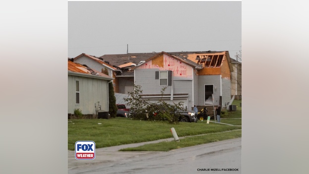
Storm damage in Benton, Missouri
Debris is strewn across a neighborhood, trees have been ripped from the ground and homes show signs of damage.
As the cleanup begins, first responders are already on the scene, working swiftly to assess the damage and help the impacted community start the road to recovery.
In the northeastern Illinois town Lena is assessing storm damages as the area remains under severe thunderstorm warning.
Stephenson County Sheriff Steve Stovall said on Facebook that the Village of Lena is shut down, and there will be no traffic in or out of the town until further notice.
Amid an ongoing severe weather outbreak, the Stephenson County Sheriff's warned "Please avoid the town of Lena!"
In a Facebook post, Stephenson County Sheriff's Office said there is no way to get into the northwestern Illinois town due to trees and wires down.
According to Sheriff Steve Stovall, emergency services are assisting people.
Amid a sprawl of severe storms rolling through the The Village of Lena said that officials were dealing with damage from an earlier tornado, and warned that conditions could get worse quickly.
Severe Thunderstorm Warnings continues for Lena and surrounding areas until 6:45 PM CDT.
Thousands of power outages have been reported across the Plains and the Midwest as severe storms slam the area.
PowerOutage.us reported the following outages:
Kansas: 10,000+ power outages
Missouri: 14,000+ power outages
Illinois: 16,000+ power outages
Wisconsin: 15,000+ power outages
Thunderstorms are impacting flights at Chicago's O'Hare (ORD) Airport. The Federal Aviation Administration said there is currently a Ground Delay in effect until early Saturday Morning.
Arrivals into Chicago O'Hare are delayed on average over 3 hours, according to the FAA.

A Flash Flood Warning is in effect for Kansas City, Missouri.
A Flash Flood Warning is in effect for Kansas City, Missouri, as severe storms move through the area.
The National Weather Service has received reports of stalled cars in standing water on Interstate 70.
Wind gusts of 70 mph have also been reported.
SEVERE WEATHER HQ 🌪️: FOX Weather Storm Trackers in the field capturing eye-catching video of a severe weather outbreak across the Central U.S.
The FOX Weather Beast team featuring Meteorologist Haley Meier, as well as FOX Weather Exclusive Storm Trackers Brandon Copic and Corey Gerken pursue a confirmed tornado near Rockton, Illinois.
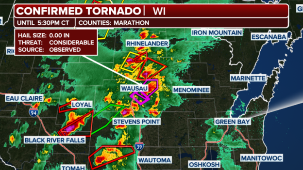
A PDS tornado touches down in Marathon County, Wisconsin.
A confirmed PDS - Particularly Dangerous Situation - tornado has touched down in Wisconsin.
Marathon County is under a Tornado Warning through 5:30 p.m. CT, according to the National Weather Service.
Anyone in the storm's path should take shelter immediately.
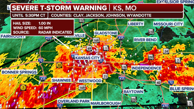
Severe thunderstorms are slamming the Kansas City metro, with a warning in effect until 5:30 p.m. CT.
Severe Storm Reports
The storm is targeting Clay, Jackson, Johnson and Wyandotte counties in Kansas and Missouri, bringing the threat of quarter-sized hail and wind gusts up to 60 mph.
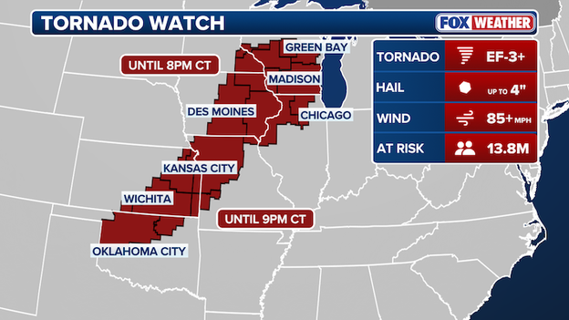
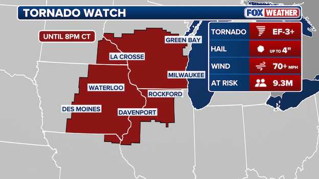
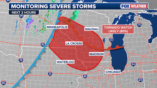
A Tornado Watch has been issued for parts of Illinois and Missouri through 11 p.m. CDT, has been extended to include Chicago and St. Louis, among other areas in the Midwest.
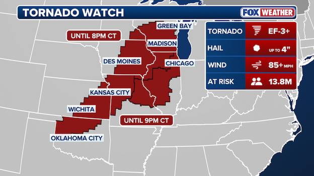
Tornado Watch Map
A few strong tornadoes — potentially EF-3 or higher — are possible, along with scattered hail up to the size of tennis balls and widespread damaging wind gusts.
The watch includes Chicago and places 13 million people under Tornado Watch, as millions across the Heartland brace for a Friday evening severe weather event likely to disrupt weekend plans across the region.
At 3:33 pm CDT, a confirmed large and extremely dangerous tornado was located near Montana, Wisconsin.
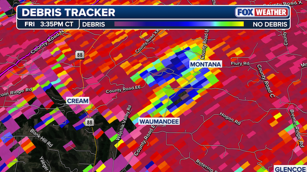
Debris Tracker
The NWS said additional tornadoes could form along a line extending from 8 miles southeast of Modena to 9 miles north of Fountain city to Goodview, moving northeast at 45 mph.
The NWS Warning said: "This is a particularly dangerous situation. Take cover now!"
"You are in a life-threatening situation. Flying debris may be deadly to those caught without shelter. Mobile homes will be destroyed. Considerable damage to homes, businesses, and vehicles is likely and complete destruction is possible," the NWS Warning alerted.
Governor Mike Kehoe has declared a State of Emergency in Missouri in preparation for 'potentially dangerous severe weather' forecast to slam the majority of the state.
“This Executive Order is a proactive step to ensure our emergency management teams are fully prepared should these storms require immediate action to protect Missourians," said Governor Kehoe.
“While the State Emergency Operations Center is activating to support any necessary coordination efforts, Missourians should take this forecast seriously and be ready to act if conditions worsen."
With a looming threat of massive hail, damaging winds and EF-2 or greater tornadoes, Governor Kehoe, emphasized that keeping Missourians safe is the top priority.
“My team has been in close contact with the National Weather Service throughout the day, and the latest information shows the threat of these storms—especially in the Kansas City area—warrants this action," continued Governor Kehoe.

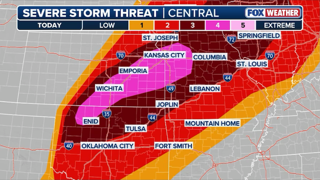
Severe Storm Threat area
An upgrade to a Level 4 of 5 severe weather risk has been issued for western Missouri, while the rest of the state remains under lower threat levels.
A Flood Watch is also in effect for parts of western, southwestern and central Missouri, where additional rainfall could trigger localized flash flooding overnight following significant rain over the past 24 hours.
“Keeping Missourians safe is our top priority as this system continues throughout the day and into the night. Stay aware of local forecasts, follow official warnings, and ensure you have multiple ways to receive alerts overnight," Governor Kehoe said.
Severe thunderstorms, active warnings and confirmed tornadoes are lighting up the Heartland as a widespread severe weather outbreak puts millions at risk heading into the weekend.

Live Radar as of 3 pm CST
A line of severe storms stretched across the Central U.S., lighting up live radar around 3 p.m. CT as millions brace for a dangerous weekend ahead of large hail, damaging winds and possible tornadoes.
On radar, yellow indicates severe thunderstorms, red boxes mark Tornado Warnings (12 simultaneous as of 3 p.m. CST), and purple highlights areas with confirmed tornadoes.
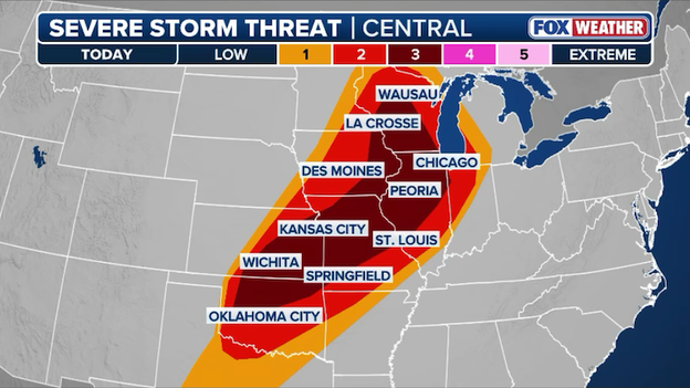
Earlier today, the Storm Prediction Center upgraded parts of western Missouri, southeastern Kansas and northwestern Oklahoma to a Level 4 of 5 severe weather risk due to the increasing threat of large hail and destructive winds.
Elsewhere, a Level 3 of 5 risk extends into the Upper Midwest, while a broader Level 2 of 5 threat stretches from the Upper Midwest south into North Texas.
Altogether, today’s severe weather threat spans nearly 1,500 miles and includes roughly 50 million people.
Due to the threat of severe weather, Kansas Speedway announced it will close its grandstands today ahead of a major NASCAR Cup Series race.
The Kansas City racetrack sits within a corridor stretching from Oklahoma to Missouri that is under a heightened Level 4 of 5 severe weather risk today.
The closure comes ahead of the highly anticipated AdventHealth 400, the ninth NASCAR Cup Series race of the season, scheduled for Sunday, April 19.
A Minnesota Department of Transportation camera near Rochester, Minnesota, captured a tornado as it formed and appeared to touch the ground.
FOX Weather Meteorologist Haley Meier is in the field tracking the severe storms as they blast through the Midwest this afternoon.
The Storm Prediction Center has issued a new Tornado Watch for parts of the Heartland until 9 p.m. CT where the threat for tornadoes, destructive winds, and huge hail is increasing right now.
The Storm Prediction Center has issued a Tornado Watch for a large portion of the Heartland, covering parts of northern and western Missouri, eastern and southern Kansas, and northern and western Oklahoma until 9:00 p.m. CT.
This watch comes as a powerful cold front collides with a highly unstable air mass, creating a volatile environment where dangerous storms are expected to erupt.
Forecasters warn that initial storms will likely be discrete supercells, which pose the greatest threat for intense tornadoes and monster hail reaching 4 inches in diameter.
As the evening progresses, these individual storms are expected to merge into a fast-moving squall line, shifting the primary hazard toward destructive straight-line winds.
Residents in cities like Kansas City, Topeka, and Tulsa should remain vigilant, as hurricane-force wind gusts of 80 to 90 mph are possible within this line.
Because these storms are moving into an area with already saturated soils, flash flooding is also a significant concern.
Make sure you have multiple ways to receive warnings and are prepared to seek shelter immediately if a warning is issued for your area.
A dangerous flash flooding threat is developing across the Midwest this afternoon as a fire hose of tropical-level moisture slams into soils that are already completely saturated.
While today’s individual storms will be moving fast, the FOX Forecast Center is warning of a phenomenon called storm training, where multiple rounds of intense rain follow the same path like cars on a train track.
Heavy rain and "training storms" will increase the threat for flash flooding across portions of the Midwest through the evening hours.
Because the ground is already like a soaked sponge and cannot absorb another drop, rain rates of 1 to 2 inches per hour will quickly turn into runoff, causing water to rise rapidly in streets and small creeks.
People from Iowa to Minnesota should prepare for localized totals of up to 4 inches of rain, which could lead to significant flash flooding in both rural areas and city centers through the evening.
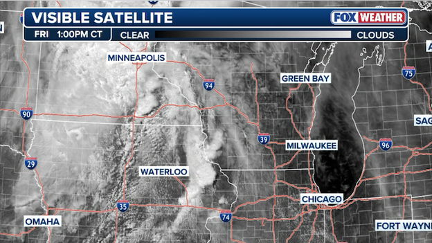
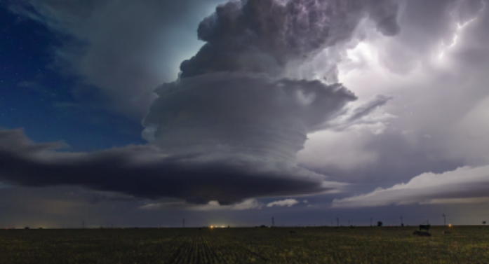
Visible satellite image from GOES East showing explosive storm development over portions of the Midwest this afternoon.
Visible satellite imagery is currently capturing a classic and dangerous bubbling effect over eastern Iowa, as towering cumulus clouds rapidly explode into massive supercells.
These towering chimneys of clouds indicate that the atmospheric cap has completely broken, allowing storms to tap into extreme energy and grow into powerful thunderstorms in a matter of minutes.
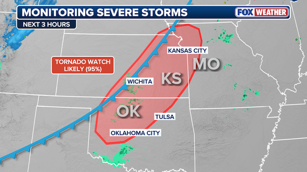
The Storm Prediction Center says it will likely issue a Tornado Watch for portions of Kansas and Oklahoma as the severe storm threat ramps up this afternoon.
The Storm Prediction Center is preparing to issue a Tornado Watch for a massive area stretching from northern Missouri through Kansas and into Oklahoma as the atmosphere reaches a breaking point.
A volatile mix of high humidity and record-level energy is currently acting like rocket fuel for developing storms, creating a powder keg that is expected to explode within the next one to two hours.
FOX Weather meteorologists are warning that the first storms to fire will be powerful supercells capable of dropping giant hail larger than grapefruits (over 3 inches) and potentially producing strong tornadoes.
As the afternoon turns to evening, these individual storms are expected to merge into a high-speed wall of wind with hurricane-force gusts topping 80 to 90 mph, making it critical for residents across the Heartland to have a severe weather plan in place immediately.
Parts of Wisconsin, Iowa, and Minnesota are under a Tornado Watch until 8:00 p.m. CT, which means conditions are favorable for severe weather to develop.
The Storm Prediction Center has issued a Tornado Watch for portions of Wisconsin, Minnesota, Iowa, Illinois, and Missouri as the threat of life-threatening storms intensifies.
This watch is in effect until 8:00 p.m. CT and covers a region where the atmosphere is primed for the development of powerful supercells.
Forecasters are warning that any storms that form in this volatile environment will be capable of producing intense tornadoes, as well as monster hail larger than 3 inches in diameter and damaging wind gusts up to 70 mph.
The watch includes major population centers where the combination of high humidity and shifting winds at different altitudes is creating a perfect storm for rotation.
If you are in the watch area, now is the time to identify your safe space—ideally an interior room on the lowest floor of a sturdy building—and keep your phone charged with FOX Weather App notifications enabled. Conditions are expected to deteriorate rapidly as a line of storms pushes through the region later this afternoon.
A Tornado Watch is expected from the Storm Prediction Center for portions of the Midwest over the next hour or two as conditions become favorable for severe weather to develop.
Conditions are rapidly coming to a head across southeast Minnesota, northeast Iowa, and western Wisconsin as a volatile triple point—the intersection of a warm front, cold front, and dryline—sharpens over the region.
Meteorologists are tracking a window of high danger this afternoon as discrete supercells are expected to erupt in an environment characterized by extreme instability and strong low-level wind shear.
These isolated storms will have the potential to produce intense tornadoes and giant hail exceeding 3 inches in diameter. The Storm Prediction Center has indicated that a Tornado Watch is likely to be issued shortly for this corridor to account for the increasing threat of long-track, powerful tornadoes.
A Level 4 of 5 severe weather threat zone has been issued by the Storm Prediction Center. Intense tornadoes, destructive winds, and damaging hail are all expected as severe thunderstorms erupt across the region this afternoon and into the evening.
The Storm Prediction Center has just issued a rare Level 4 of 5 for a large swath of the Heartland, including northwest Oklahoma, central and eastern Kansas, and west-central Missouri.
This upgrade is a significant heads-up from meteorologists that a high-end weather event is likely to unfold this afternoon. The decision to move to a Level 4 risk stems from increasing confidence that vicious storms will produce widespread damaging winds and damaging hail in the region.
The forecast center is tracking two primary phases of danger today. First, individual supercell storms will fire off this afternoon, capable of producing what forecasters call monster hail—some stones could exceed 3 inches in diameter, or larger than a grapefruit.
While these initial storms pose an intense tornado risk, the upgrade accounts for what happens this evening: these individual storms are expected to clump together into a massive, fast-moving wall of wind.
This squall line could produce hurricane-force gusts of 80 to 90 mph, capable of widespread power outages and structural damage as it marches toward the Mississippi Valley.
The National Weather Service in Topeka, Kansas is launching a special weather balloon at 1:00 p.m. CT to get a real-time look at the rapidly destabilizing atmosphere.
This extra data will provide meteorologists with critical vertical profiles of temperature, moisture, and wind shear, helping them pinpoint exactly when and where the most dangerous supercells will ignite this afternoon.
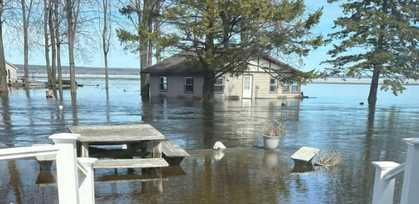
A dangerous combination of record-breaking spring rain and rapid snowmelt is triggering historic flooding across Michigan and Wisconsin.
With Marquette, Michigan, recording its second-snowiest season on record at over 273 inches, the transition to warmer temperatures is sending a massive volume of water into local waterways.
This perfect storm of conditions is being exacerbated by a historic snowpack melting into frozen ground, forcing rivers to rise well beyond their banks.
Cities like Traverse City and Gaylord are already seeing their wettest spring on record, with some areas more than a foot above average rain, leading to efficient runoff and immediate flash flooding.
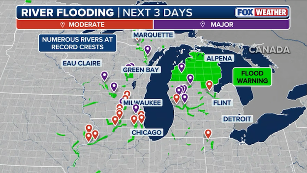
Historic flooding has swamped the Great Lakes region with numerous rivers recording record crests.
The FOX Forecast Center reports that several rivers have already shattered all-time record crests.
In Michigan, the Manistee River near Sherman crushed its previous record by nearly three feet, while the Muskegon River has hit record peaks at multiple stations including Newaygo and Evart. In Wisconsin, the Wolf River at Shiocton has also reached a new historic high.
With an additional 2 to 3 inches of rain forecast through Saturday, Flood Watches remain in effect as the saturated ground can no longer absorb the moisture.
People in Marquette, Alpena, and Sault Ste. Marie should remain on high alert as these record-breaking water levels continue to threaten homes and infrastructure through the weekend.
With a serious severe weather threat looming over the Kansas City metro, several area school districts are taking no chances and have announced early dismissals for Friday.
Kansas City Public Schools are among those releasing students several hours ahead of schedule—with some dismissals as early as 10:50 a.m. CT—to ensure that children, staff, and bus drivers are safely home before the most volatile storms arrive.
Other districts have canceled all evening activities and warned parents to be ready for rapid schedule changes as the timing of the storm's arrival becomes clearer.
Local officials emphasize that getting students off the roads before the expected monster hail and high wind gusts begin is a top priority.
Today’s dangerous weather is being powered by a surge of warm, humid air clashing with a powerful storm system moving in from the Rockies.
This combination is creating a powder keg effect in the atmosphere, providing plenty of fuel for storms to explode quickly.
Strong wind shear across the Midwest will support the development of intense tornadoes into this evening.
By mid-afternoon, the main concern will be individual, discrete storms that can spin easily. These isolated cells are the ones most likely to produce the biggest threats, including monster hail and intense tornadoes that could stay on the ground for a significant amount of time.
As we head into the evening hours, these individual storms are expected to clump together into a massive, fast-moving line.
When this happens, the primary danger shifts from tornadoes to destructive straight-line winds. Forecasters are warning that these winds could scream at 60 to 90 mph—similar to the strength of a hurricane—toppling trees and knocking out power as the line marches through the Missouri Valley and toward the Great Lakes.
Even though the storms will be in a line, they can still produce spinups, so it is vital to stay alert until the entire system passes your area.
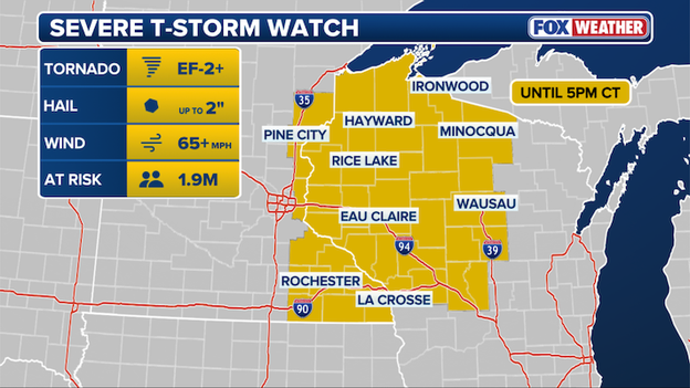
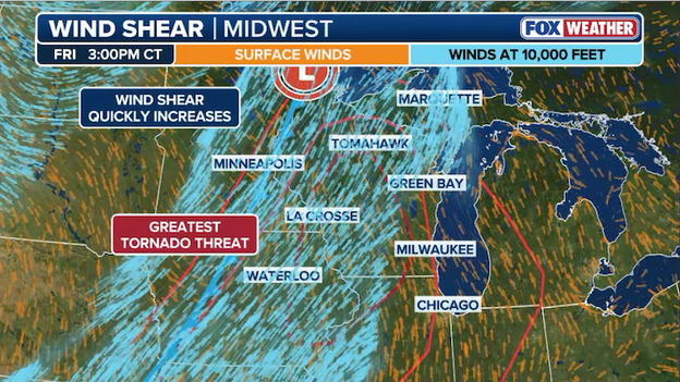
A Severe Thunderstorm Watch is in effect for portions of the Upper Midwest until 5 p.m. CT.
The Storm Prediction Center has issued a Severe Thunderstorm Watch effective until 5:00 p.m. CT for portions of east-central and far southeast Minnesota, as well as northwest and north-central Wisconsin.
An ongoing line of storms moving northeast is expected to intensify as it encounters a more unstable environment, with additional storm development likely throughout the afternoon.
Residents in the watch area, including those near Eau Claire and La Crosse, should be prepared for scattered large hail up to 2 inches in diameter and isolated damaging wind gusts reaching 70 mph.
A dangerous weather setup is unfolding today as a large upper-level disturbance shifts out of the Rockies, placing more than 50 million people under the threat of life-threatening storms.
The FOX Forecast Center warns that as moist, unstable air surges northward, two distinct rounds of severe weather will impact a 1,500-mile corridor stretching from the Great Lakes to the Southern Plains.
Residents in major hubs like Chicago, Kansas City, and Wichita should prepare for an initial wave of discrete supercells capable of producing monster hail and intense, long-track tornadoes—some potentially reaching EF-3 strength—particularly across eastern Iowa, southern Wisconsin, and northern Illinois.
Severe thunderstorms are expected to erupt across America's Heartland today with more than 54 million Americans at risk.
As the afternoon progresses into the evening, the storm mode is expected to transition into a powerful squall line as a cold front dives south toward St. Louis and the surrounding regions.
This transition shifts the primary hazard to a significant damaging wind event, with gusts potentially exceeding 75 mph alongside the continued risk of large hail and embedded tornadoes.
With a Level 3 out of 5 risk centered over the heart of the Midwest, it is critical to stay weather-aware and have multiple ways to receive warnings as these destructive storms move through.
You’ve reached the beginning of this live coverage.