

Live updates: Deadly nor'easter floods the coast as dangerous winds whip through the Northeast
Live updates: Deadly nor'easter floods the coast as dangerous winds whip through the Northeast
Download the App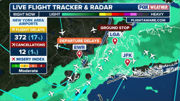
The Federal Aviation Administration (FAA) has again extended the ground stop at LaGuardia Airport (LGA) until at least 11:00 a.m. ET.
The Federal Aviation Administration (FAA) has once again extended the ground stop at LaGuardia Airport (LGA), with inbound flights now held on the ground until at least 11:00 a.m. ET—and officials warn it could be extended further.
This targeted air traffic hold is currently impacting flights departing from specific Mid-Atlantic airports bound for LGA as air traffic controllers continue to manage heavy regional congestion, low cloud ceilings, and strong wind gusts.
Travelers flying through the region should prepare for cascading schedule pushbacks and check directly with their carrier for real-time status updates throughout the morning.


Exclusive analysis from FOX Weather hurricane specialist Bryan Norcross
The nor'easter just offshore of the New Jersey Coast is weakening and the trend will continue through the day as the system slowly moves away from New Jersey tonight.
Where winds are onshore, flooding is still likely at high-tide times today. Flooding is still possible in bays, harbors, and sounds where the water is trapped.
Midday high tides in the western end of Long Island Sound might affect operations at LaGuardia Airport in New York, for example.
Later in the day, as the winds subside, the floodwaters that have been held in place will be able to begin to drain.
The storm behaved essentially as expected with two phases to the storm.
There were widespread impacts, but mostly near the coast where the winds were highest and relentless.
Initially, the strong high-pressure system over Quebec combined with the developing low-pressure area off the Carolinas squeezed the air into a strong northeast jet that pushed the ocean over the coast from North Carolina to the Mid-Atlantic.
That northeast jet part of the storm, which was north of the front connected to the low, ended up in New England.
The southern side of that streak of strong winds just north of the front was where the thunderstorms and heavy rain occurred.
Meanwhile, the low center itself organized, which spread rain and its separate area of strong winds over southeastern New York and New Jersey as it drifted toward the Jersey Shore.
Effects will linger in the Northeast through tomorrow, but nice dry weather will return after that.

FOX Weather viewers are sharing dramatic photos showing severe coastal flooding inundating neighborhoods along the bay directly across from Island Beach State Park, New Jersey, this morning.
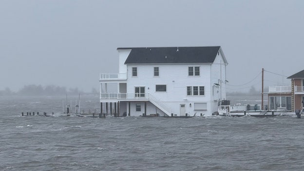
Photo submitted by FOX Weather viewer Karen S
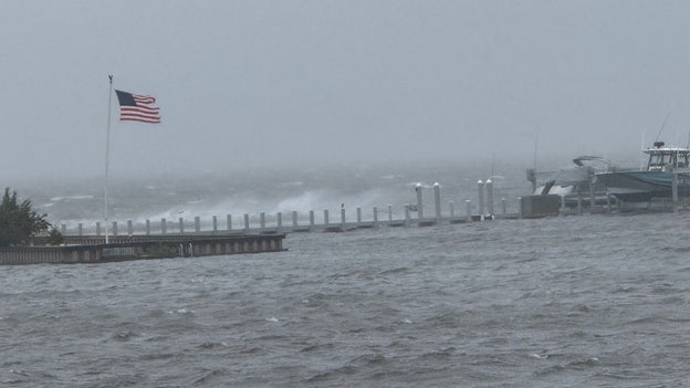
Photo submitted by FOX Weather viewer Karen S
Pushed inland by unrelenting onshore winds, high tide waters spilled over bulkheads, submerging local streets, docks, and residential driveways.
With back bays particularly vulnerable to water accumulation during this slow-moving nor'easter, local officials continue to urge coastal residents to keep vehicles parked on higher ground as floodwaters slowly recede.
Fans heading to MetLife Stadium to watch the New York Giants take on the Tennessee Titans today should prepare for slick, wet, and windy conditions as the nor'easter continues to impact the region.
The exclusive FOX Weather ROWI (Risk Of Weather Impact) index is currently set at Medium, warning that persistent rain bands and swirling wind gusts could directly affect play on the field, forcing teams to rely heavily on the ground game and challenging kicking and passing accuracy.
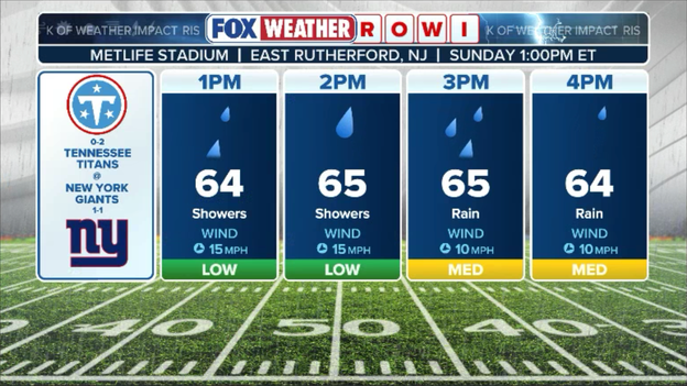
Exclusive FOX Weather ROWI (Risk Of Weather Impact) forecast
Spectators in the stands are advised to gear up in heavy waterproof outerwear, as gusty winds will make rain ponchos essential throughout the game.

Even as the nor'easter slowly weakens, coastal residents won't be out of the woods just yet: FOX Weather meteorologists warn that minor-to-moderate coastal flooding is expected to linger through Monday's high tide cycles across parts of the Mid-Atlantic and southern New England coastlines.
Onshore winds continuing to push ocean water inland, combined with elevated astronomical tides, will keep back bays and low-lying shoreline roads vulnerable to recurrent water covering during peak tide times tomorrow.
Rain totals continue to climb across southern New England as persistent bands from the slow-moving nor'easter repeatedly drench the region.
Camp Edwards, Massachusetts, currently tops the list of highest storm accumulations, recording a staggering 6.36 inches of rain so far. Westwood, Massachusetts, follows close behind, logging 5.16 inches of total rain.
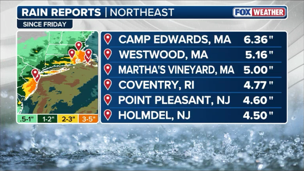
Latest top rain totals from the nor'easter
With saturated ground conditions and ongoing downpours, localized urban flooding and elevated stream levels will remain a major hazard across eastern Massachusetts through the remainder of the day.
The nor'easter is turning major Northeast aviation hubs into the nation's worst travel bottlenecks today.
LaGuardia Airport (LGA) currently leads the country in flight disruptions with over 170 delays logged so far this morning as high winds and ground stops throttle capacity.
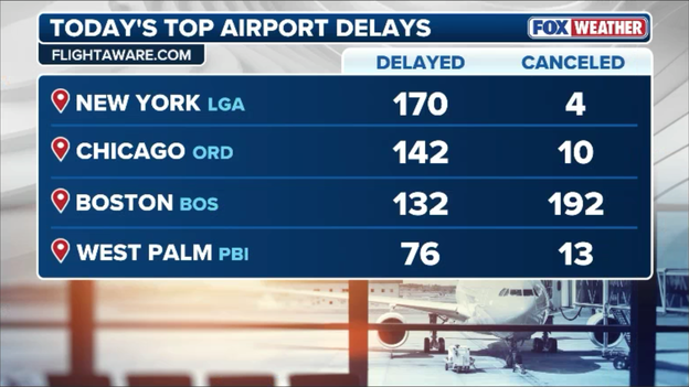
List of worst airport disruptions across the U.S. today
Meanwhile, conditions at Boston Logan International Airport (BOS) remain equally frustrating, with 132 flight delays and another 192 flights canceled outright as heavy rain and fierce wind gusts sweep through New England.
Passengers traveling through either airport are strongly advised to check their flight status before heading out, as cascading delays are expected to impact connecting routes nationwide throughout the day.
Just when New York City gets a temporary respite, computer weather models show another round of soaking rain is on the horizon.
The latest exclusive FOX Weather Model indicates that a fresh, heavy rain band wrapping around the offshore nor'easter will take direct aim at the NYC metropolitan area later this evening.
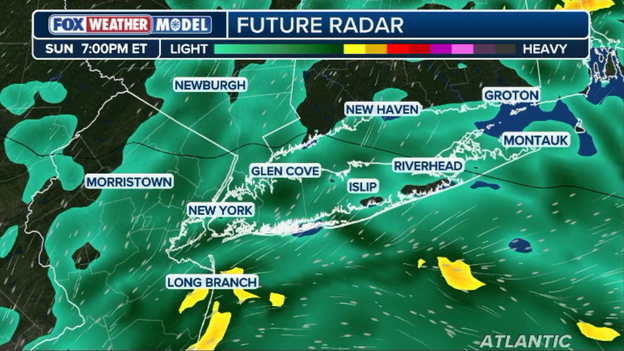
Exclusive FOX Weather Model showing another band of heavy rain taking aim at New York this evening.
Forecasts suggest this secondary push could dump an additional 1 to 2 inches of rain across the five boroughs, escalating the risk of localized street flooding, clogged catch basins, and hazardous driving conditions through the night.
A striking side-by-side satellite image reveals an eerie historical coincidence over the Northeast today. Exactly 41 years ago today—on September 27, 1985—a nearly identical, massive storm swirl hovered over the exact same stretch of coastline.
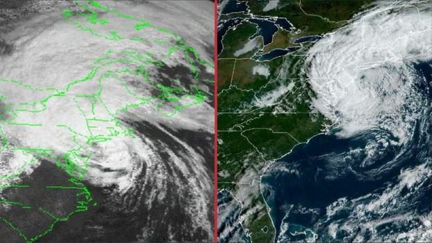
Hurricane Gloria (left) striking the Northeast in 1985 and the fall nor'easter (right) hitting the same region today.
But while today's system is a powerful, slow-moving non-tropical nor'easter, the 1985 image captured Hurricane Gloria making a direct landfall on Long Island with damaging 85+ mph winds.
While the meteorology behind a warm-core hurricane and a cold-core nor'easter differs, the visual footprint off the Mid-Atlantic coast is a staggering reminder of the atmosphere's power to shape Northeast weather history on this calendar date.
New York State Police and State Park Police are asking the public for urgent assistance as they investigate a missing person report at Robert Moses State Park on Long Island.
On Saturday afternoon around 2:30 p.m. ET, an unidentified white male wearing dark-colored shorts was seen entering the dangerous ocean surf near Field 3 before disappearing from view without being seen exiting the water.
Swimming remains strictly prohibited across area beaches amid treacherous rough seas and rip currents generated by the nor'easter.
Anyone with a family member, friend, or acquaintance who was at Robert Moses State Park on Saturday and remains unaccounted for is urged to call the New York State Police at 631-756-3300 or State Park Police at 631-321-3700.
Travelers passing through Newark Liberty International Airport (EWR) are facing compounded headaches this morning as a reported bird strike has triggered additional departure delays on top of ongoing weather disruptions.
The incident forced airport operations to briefly inspect and manage runway traffic, adding extra hold times for departing aircraft already struggling against strong crosswinds and low visibility from the nor'easter.
Passengers flying out of Newark should anticipate extended wait times on the tarmac and check directly with their airlines for updated flight information throughout the morning.
Power outages are surging across the Northeast this morning as howling wind gusts and waterlogged soil continue to uproot trees and snap utility lines.
More than 40,000 customers are currently without power in New York, while over 31,000 in Connecticut and nearly 20,000 in New Jersey are facing blackouts.
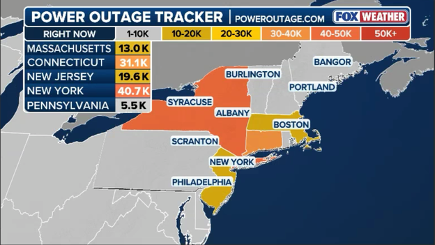
Latest power outages across the Northeast (PowerOutage.com)
Utility crews are on standby and actively working to restore power, but severe wind gusts and hazardous road conditions are hampering repair efforts as storm conditions peak across the tri-state area.
The Federal Aviation Administration (FAA) has extended the ground stop at LaGuardia Airport (LGA) until 10:00 a.m. ET as strong wind gusts and low visibility from the nor'easter continue to stall regional air traffic.
Flights departing from Northeast airports bound for LGA remain held at their gates, with cascading delays expected across the East Coast flight corridor throughout the morning.
FOX Weather Correspondent Katie Byrne reports live from Ocean City, New Jersey, where communities are bracing for another round of severe coastal flooding during today's high tide cycles.
As the strengthening nor'easter makes a direct hit along the Jersey Shore, persistent onshore winds and massive waves continue to drive water into back bays and flood low-lying roadways.
FOX News Multimedia Reporter Caroline Elliott reports live from Long Beach, New York, where intense wind gusts and dangerous ocean waves generated by the strengthening nor'easter have kept almost all surfers out of the water.
Emergency officials continue to warn residents to stay clear of shoreline structures and avoid venturing into the rough surf as pounding waves churn along coastal beaches.
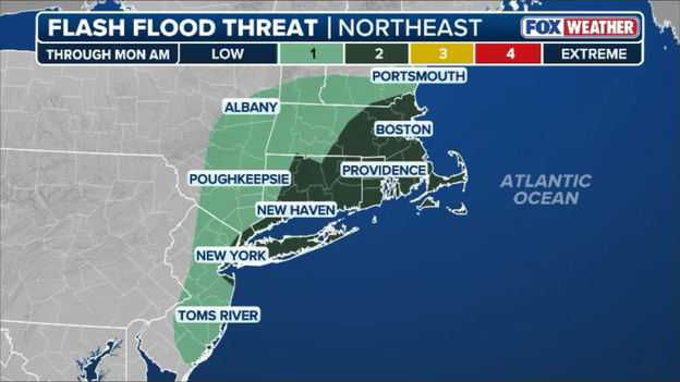
Flash flooding concerns continue across portions of the Northeast and southern New England.
A persistent threat of flash flooding continues across southern New England and low-lying coastal areas today as relentless rain bands continue to wrap around the offshore nor'easter.
With soils completely saturated from multi-day rain totals and downpours pouring over urban drainage basins, localized street flooding and rapid stream rises remain major concerns.
Emergency managers urge drivers in vulnerable coastal and low-lying neighborhoods to remain alert for water-covered roadways and avoid traveling through flooded corridors as rain continues through the day.
The Federal Aviation Administration (FAA) has issued a ground stop for LaGuardia Airport (LGA) in effect until 9:15 a.m. ET, halting all flights originating at Northeast airports that are scheduled to land at LGA.
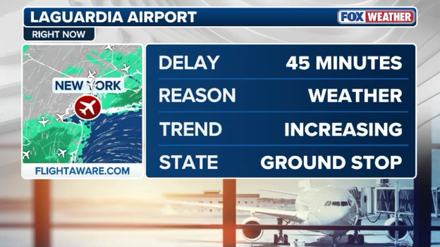
The Federal Aviation Administration (FAA) has issued a ground stop for LaGuardia Airport (LGA) in effect until 9:15 a.m. ET.
A ground stop is an air traffic management measure that holds aircraft on the ground at their departure airports, preventing them from taking off for a specific destination when weather or capacity issues become critical.
Designed to manage safety amid high crosswinds, low cloud ceilings, and reduced runway visibility, this current order specifically targets regional departure hubs in the Northeast, with cumulative delays expected to ripple outward as operations remain restricted.
Morning Doppler radar analysis shows widespread rain continuing to sweep across the Northeast as the relentless nor'easter maintains its grip on the region.
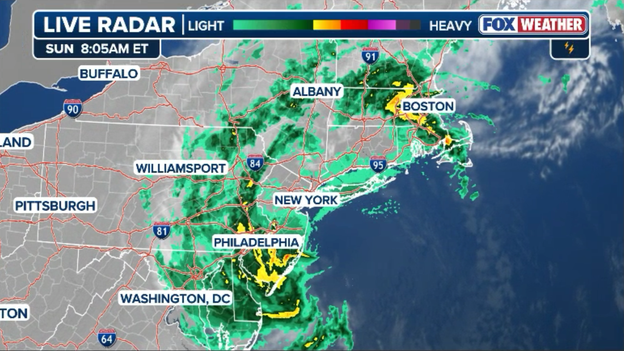
Radar showing rain wrapping into the Northeast as the nor'easter swirls over the region.
While some areas throughout the Mid-Atlantic and southern New England may experience brief lulls in precipitation over the next few hours, forecasters warn that these dry breaks will be short-lived.
A fresh push of moisture wrapping around the storm's core is expected to reenergize rain bands later today, bringing moderate to downpours back into New York and surrounding communities into the afternoon.
A 56-year-old New York City Housing Authority (NYCHA) worker was tragically killed Saturday afternoon after being struck by a falling tree in East New York, Brooklyn.
First responders arrived at Euclid Avenue around 3:30 p.m. ET to extract the maintenance worker, later identified as Leighton Brown, after an uprooted tree collapsed on him in a parking lot during peak nor'easter wind gusts.
He was rushed to Brookdale Hospital, where he was pronounced dead.
NYCHA expressed deep sadness over the tragic loss of the dedicated employee as crews across the city work overtime to clear hundreds of storm-damaged and fallen trees.
Boston Logan International Airport (BOS) is now under a major ground delay as severe nor'easter winds and low visibility severely impact air traffic operations.
Flights bound for Boston are experiencing staggering delays averaging over four hours, with cancellations continuing to pile up as peak storm conditions hit New England.
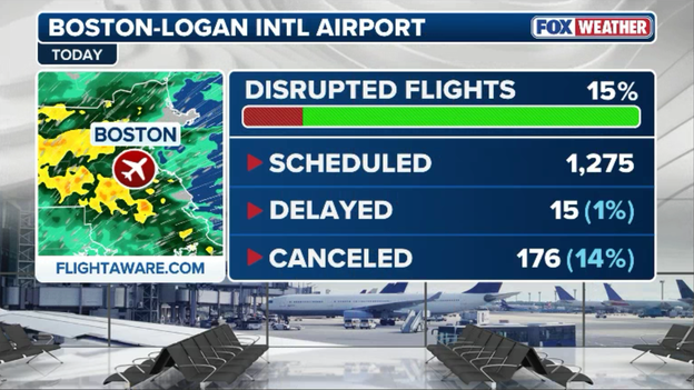
Boston Logan International Airport is facing significant flight delays due to powerful winds.
Vicious wind gusts generated by the slow-moving nor'easter continue to batter coastal communities across the Northeast, peaking at a staggering 74 mph in Surf City, New Jersey.
These destructive winds are continuing to down trees, snap power lines, and drive ocean waters deep inland across low-lying coastal areas.
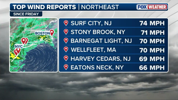
Fall nor'easter top wind gusts
Persistent rain wrapped around the strengthening nor'easter continues to drench the Northeast, dropping inches of water across southern New England and triggering localized urban and poor-drainage flooding.
Rain reports highlight some of the highest accumulations so far, including 3.79 inches recorded in Pocasset, Massachusetts, and 2.93 inches in West Greenwich, Rhode Island.
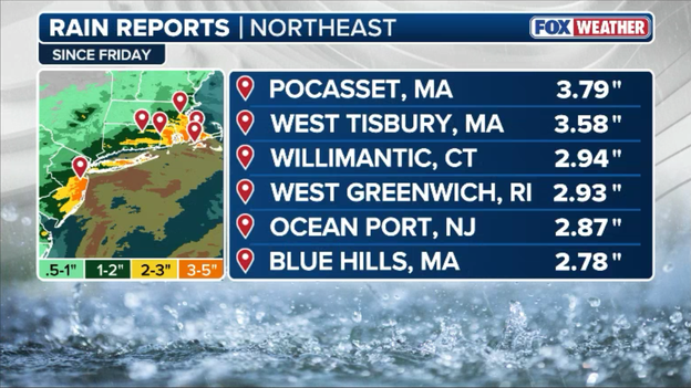
Top rain totals so far from the fall nor'easter
With heavy rain bands expected to persist through the weekend, forecasters warn that additional rainfall will exacerbate ongoing coastal flooding and keep runoff levels dangerously high across low-lying areas.
A ground delay is now in effect for LaGuardia Airport (LGA) as persistent high winds and low visibility from the strengthening nor'easter continue to impact the New York metropolitan area.
According to FAA tracking and FlightAware, incoming flights headed to LGA are experiencing average delays of just over 50 minutes.
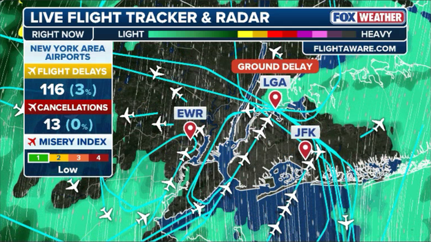
FlightAware data shows dozens of flights have been delayed already this morning at New York's major airports.
While New York area airports have logged over 116 flight delays so far, ground delays could lengthen as rain bands and strong gusts sweep across the region throughout the morning.
Passengers flying through LGA, JFK, or Newark are strongly urged to check flight statuses directly with their airlines before heading to the airport.
As the powerful coastal storm battered the East Coast, Governor Ned Lamont joined FOX Weather to discuss how Connecticut prepared for the storm and is tracking its damaging impacts.
A cute dog in Ocean City, New Jersey, bravely sailed through floodwaters in a canoe as the intense nor'easter continues to bring intense flooding to coastal communities.
Coastal communities are on high alert as Sunday morning's high tide threatens major flooding across much of the Mid-Atlantic and Northeast shorelines.
FOX Weather forecast data highlights critical peak high tide times across key locations, including Atlantic City at 8:19 a.m. ET with 2.50 ft of surge.
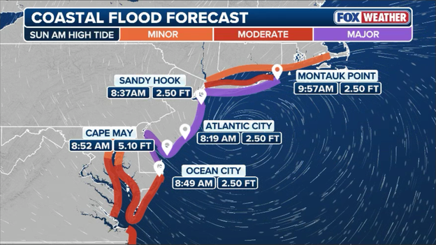
Major coastal flooding is expected again this morning as high tide coincides with the nor'easter's relentless onshore winds.
With a broad swath of the New Jersey coast into eastern Long Island under major flood threat levels, residents along bays and oceanfronts are urged to move vehicles to higher ground and prepare for dangerous, widespread inundation as water levels peak over the next few hours.
Air travel across the nation is taking a major hit as the relentless nor'easter continues to snarl schedules at major hubs.
According to tracking data from FlightAware, more than 4,400 flights have been delayed or canceled overall through the weekend.
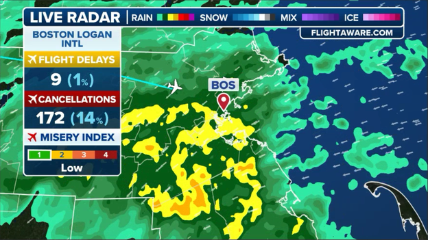
Boston Logan International Airport is reporting significant flight cancellations due to the nor'easter.
The disruption has intensified today with over 400 cancellations already logged nationwide, concentrated heavily at Boston Logan International Airport where severe winds and low visibility have grounded hundreds of flights.
Major carriers are issuing travel waivers and warning that knock-on delays will likely ripple across the entire country throughout the day.
Howling winds and waterlogged soil are knocking down trees and power lines this morning, causing power outages to stack up across the region.
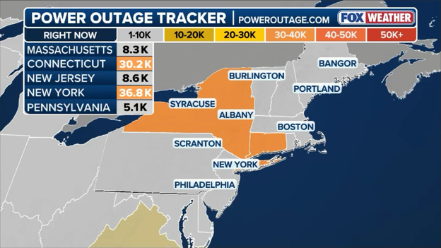
Latest power outages across the Northeast (PowerOutage.com)
New York is leading the list of hardest-hit states with over 37,500 customers in the dark, closely followed by Connecticut with more than 31,300 outages reported.
Utility crews are responding as quickly as possible, but persistent wind gusts and dangerous field conditions are complicating restoration efforts, and officials warn additional power disruptions remain likely throughout the day.
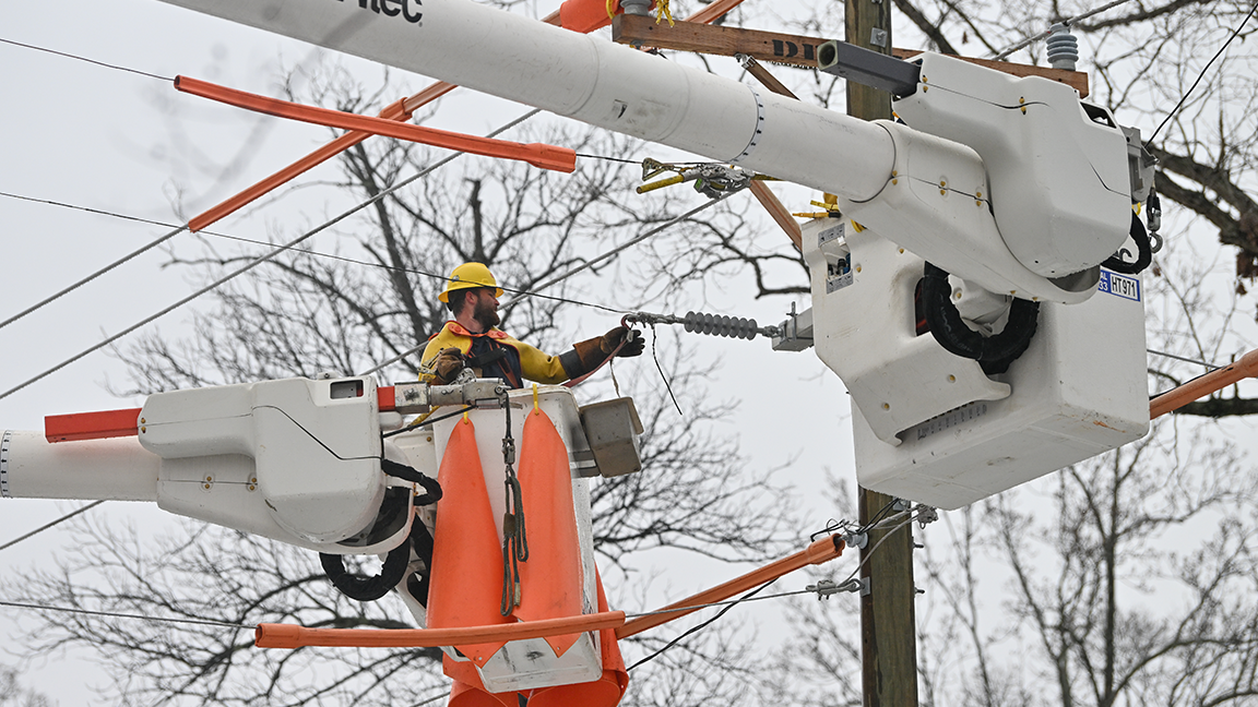
The first nor'easter of the fall season continues to drench the East Coast this weekend, bringing intense rain, damaging wind gusts, and expanding flood threats to communities across the seaboard.
Emergency officials warn that downpours and rising floodwaters will persist through the weekend as the storm churns offshore.
You’ve reached the beginning of this live coverage.