Live updates: Dangerous windstorm hits Chicago, Minneapolis as March blizzard targets millions
Live updates: Dangerous windstorm hits Chicago, Minneapolis as March blizzard targets millions
Download the AppMore than 1.18 million without power across U.S. as multiple storm systems hammer the grid
View postCoverage for this event has ended.
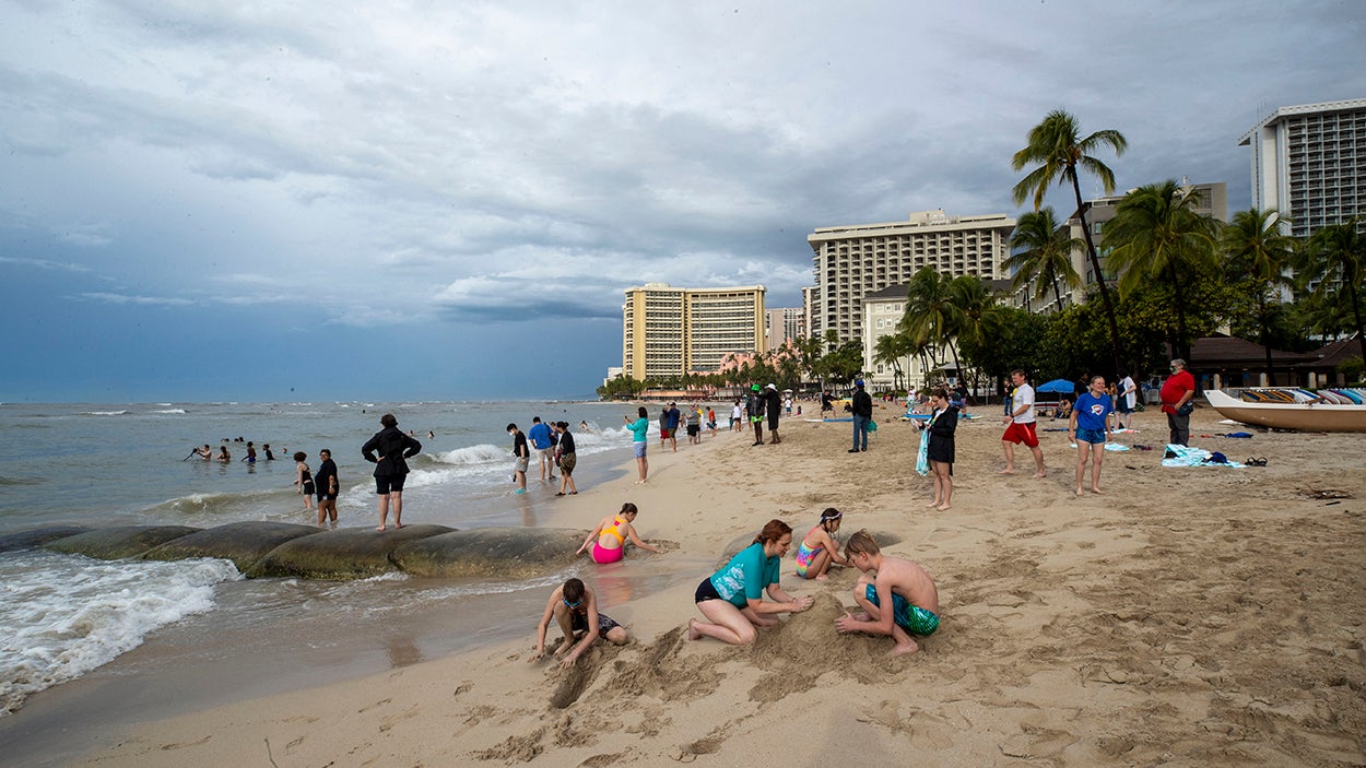
Hawaii is being battered by a Kona low, sending heavy moisture and strong winds across the islands and leaving more than one-fifth of customers statewide without power as flash flood warnings remain in effect.
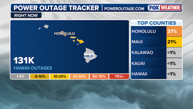
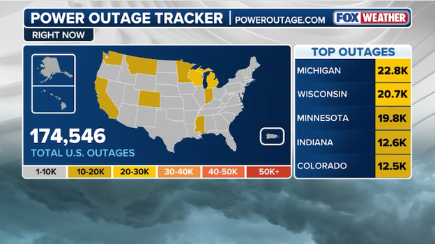
Power Outage Tracker courtesy of poweroutage.com
According to data from poweroutage.com, more than 120,000 are without power across Hawaii of 510,000 customers tracked, as high winds and heavy rain continue to hammer the Pacific island chain.
The National Weather Service Honolulu office issued a flash flood warning across the island of O'ahu, with over 1 million under threat of dangerous flash flooding as rainfall rates reached 2-3" per hour.
Heavy rain is continuing to overtake the Hawaiian Islands with ongoing heavy rain & storms. With a combination of strong upper-level forcing, deep tropical moisture, and persistent southerly flow, the environment is extremely favorable for periods of heavy rain and thunderstorms.
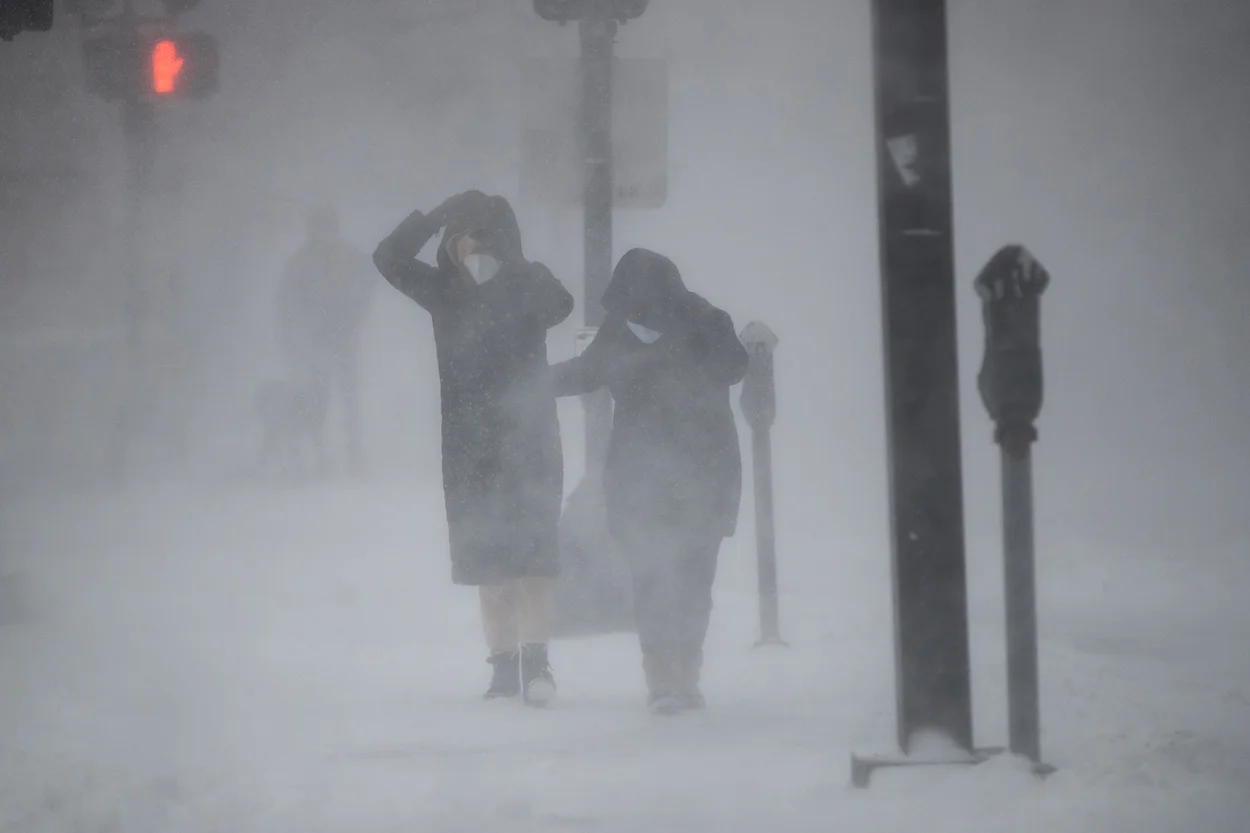
A fast-moving clipper system racing through the northern tier Friday is producing dangerous wind gusts across parts of the Midwest and Great Lakes, knocking out power, disrupting travel and creating hazardous conditions.
The storm is packing powerful, hurricane-force wind gusts as it sweeps eastward, with several locations reporting gusts approaching hurricane-force strength, according to preliminary wind reports.
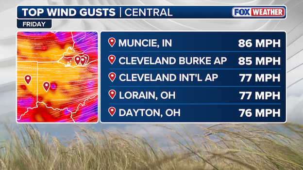
Top Wind Gusts
Among the strongest wind gusts reported Friday:
- Muncie, Indiana: 86 mph
- Cleveland Burke Airport, Ohio: 85 mph
- Cleveland Hopkins International Airport: 77 mph
- Lorain, Ohio: 77 mph
- Dayton, Ohio: 76 mph
Wind gusts above 70–80 mph are strong enough to bring down trees, snap power lines and cause structural damage, which helps explain the widespread power outages being reported across the region.
A sprawling and volatile weather pattern is knocking out electricity for more than 1 million customers across the United States, as multiple storm systems pound different regions of the country.
According to the latest data from PowerOutage.com , 1,180,801 customers were without power nationwide as of the latest update, with the heaviest concentrations of outages clustered across parts of the Midwest and Northeast.
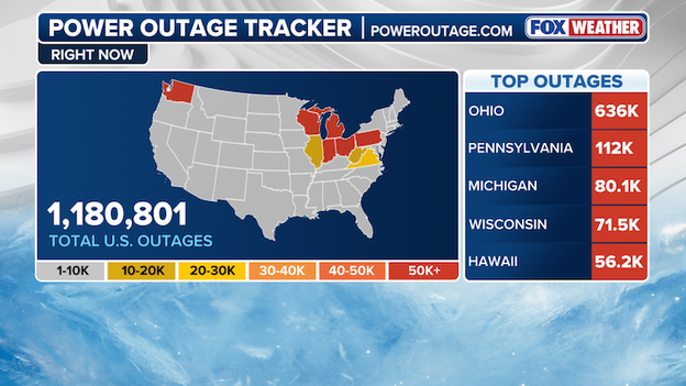
Power Outage tracker using data from poweroutage.com
Multiple weather threats driving outages. The outages come as several active weather systems move across the country.
Across the Midwest and Great Lakes, a fast-moving clipper system has brought bursts of snow and strong winds that have downed trees and power lines across the region.
Farther west, an atmospheric river in the Pacific Northwest continues to produce heavy rain and gusty conditions that can also stress electrical infrastructure.
The largest concentration of outages is in Ohio, where more than 636,000 customers are in the dark.
The outages come as strong storms and gusty winds sweep across the region, capable of toppling trees and damaging power lines. Other states reporting significant outages include:
- Pennsylvania: about 112,000 outages
- Michigan: around 80,100 outages
- Wisconsin: roughly 71,500 outages
- Hawaii: about 56,200 outages
Flight disruptions are mounting across the United States as a volatile weather pattern threatens to derail travel plans heading into the weekend.
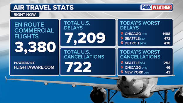
Air Travel Stats
According to data from FlightAware.com, more than 7,000 flights have been delayed nationwide Friday, while over 700 flights have been canceled, as multiple storm systems sweep across the country and snarl air traffic at some of the nation’s busiest hubs.
On the West Coast, a powerful atmospheric river slamming the Pacific Northwest is soaking the Seattle area with heavy rain — conditions that often force airlines to slow arrivals and departures, leading to cascading delays.
Meanwhile in the Midwest, a fast-moving clipper system racing across the northern tier has triggered significant disruptions around Chicago’s major airports, where bursts of snow and gusty winds are complicating operations.
Transportation Secretary Sean Duffy announced that Ronald Reagan Washington National Airport (DCA), Washington Dulles International Airport (IAD), Baltimore-Washington International Airport (BWI) and Richmond International Airport (RIC) are currently experiencing ground stops.
With active weather expected to persist into the weekend, travelers should brace for additional delays and check with their airlines before heading to the airport.

FOX Weather Meteorologist Bayne Froney analyzes the strong blizzard forecast to wallop the Midwest and Great Lakes regions. With a potential bomb cyclone brewing, winter weather alerts are in place across the regions through the weekend and into Monday.
A powerful clipper system pushing ferocious winds through Ohio is taking a mounting toll on utilities across the state, as intense wind gusts trigger widespread carnage and power outages.
According to data from PowerOutage.com, roughly 400,000 customers are currently without power across Ohio, as strong winds continue to batter the region.
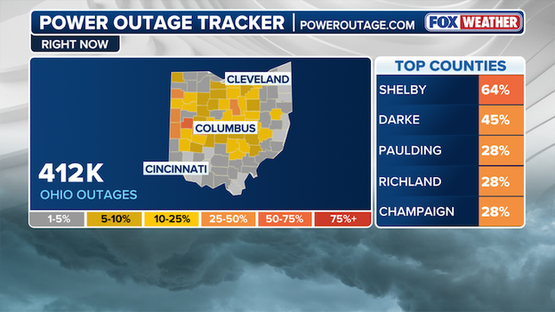
Power Outage Tracker using data from poweroutage.com
More than 80,000 customers are without power in Cuyahoga County, in northeastern Ohio along the shores of Lake Erie and home to Cleveland, Parma and Lakewood.
Wind gusts have been ferocious at times, including a 73-mph peak gust reported in Arcadia, underscoring the strength of this fast-moving system.
With 60–70 mph gusts sweeping across the state, the storm has already caused significant impacts.
Downed power lines, fallen trees, and even overturned vehicles have been reported as the powerful winds continue to create dangerous conditions across Ohio
More than 100 million Americans are at risk for severe storms through Sunday night as the March severe weather frenzy continues, with a broad Level 3/5 risk spanning multiple states.
Sunday afternoon into the overnight hours, a strengthening area of low pressure will increase surface winds ahead of an approaching cold front, drawing rich Gulf moisture northward and raising moisture levels across the region.
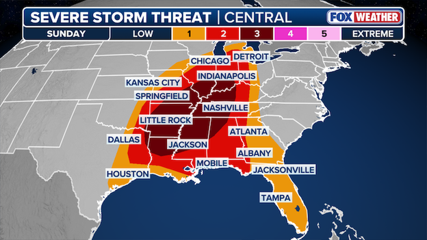
Severe Storm Outlook for Sunday
By late Sunday evening, a severe line of storms is likely to form, with widespread damaging winds increasingly probable. Some guidance suggests a high-end wind event could develop, potentially evolving into a serial derecho.
A narrow corridor for tornado development may also exist where strong shear overlaps with the line.
The highest threat extends across a widespread area from southern Indiana and Illinois southward into western Tennessee, including Indianapolis, Evansville, Bloomington, and Jonesboro within the Level 3/5 risk area.
In total, more than 100 million Americans are at risk for severe storms through Sunday night.
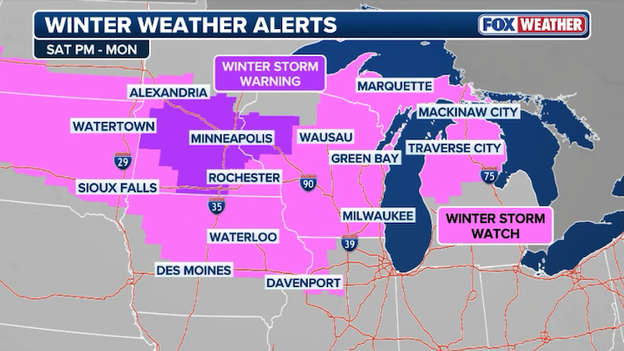
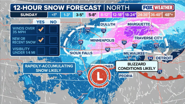
Ahead of a powerful storm set to hammer the Upper Midwest and Great Lakes, Blizzard Warnings have been issued for parts of South Dakota and Minnesota, signaling the potential for dangerous travel and near whiteout conditions.
Blizzard conditions are expected to unfold across a broad swath of central and eastern South Dakota into far western Minnesota, where strong wind gusts combined with heavy snowfall will create blowing and drifting snow beginning Saturday and potentially lasting through Monday.
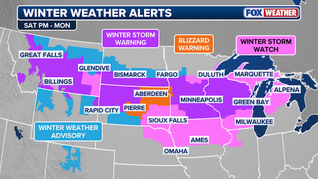
Winter Weather Alerts
The storm’s prolonged active pattern through the weekend will make travel extremely hazardous and cause significant disruptions, with proactive cancellations already underway.
FOX Weather will be tracking the storm every step of the way, delivering the latest forecasts, live updates and on-the-ground reports as this system intensifies and moves through the Midwest.
Stay with FOX Weather as we track the snow, powerful winds, and dangerous blizzard conditions as this major storm ramps up this weekend.
A fierce windstorm whipping through the Great Lakes produced a powerful 71 mph gust at Detroit Metro Airport this afternoon, creating hazardous conditions for ground operations and flight schedules.
These hurricane-force winds continue to blast the region, toppling trees and threatening the power grid as the intense clipper system moves through Michigan.
Delta Air Lines says it will begin proactively canceling flights across the Midwest as the region prepares for a significant weekend blizzard and high-wind event.
With the storm expected to rapidly intensify Saturday evening, Delta is focusing its efforts on stabilizing operations at its major Minneapolis-St. Paul (MSP) hub ahead of the first snowflake.
The safety of Delta customers and our people remains first and foremost as we closely monitor forecasts to determine necessary adjustments to flight schedules.
By processing these cancellations early, the airline aims to prevent travelers from becoming stranded at airports as the bomb cyclone brings near-zero visibility and life-threatening conditions to the Great Lakes region.
To assist those impacted, Delta has issued a travel waiver that allows customers to move their flights to a new date with no change fees or fare differences.
This flexibility is currently available for those traveling to, from, or through affected Midwest cities between Saturday, March 14, and Sunday, March 15.
The airline is encouraging passengers to use the Fly Delta app or website to rebook their trips through March 22, noting that these digital tools offer the same real-time options available to their reservation agents.
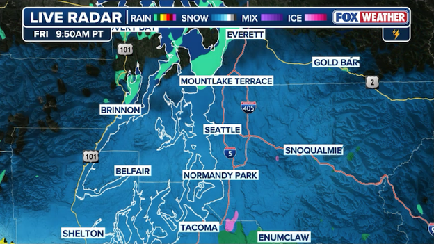
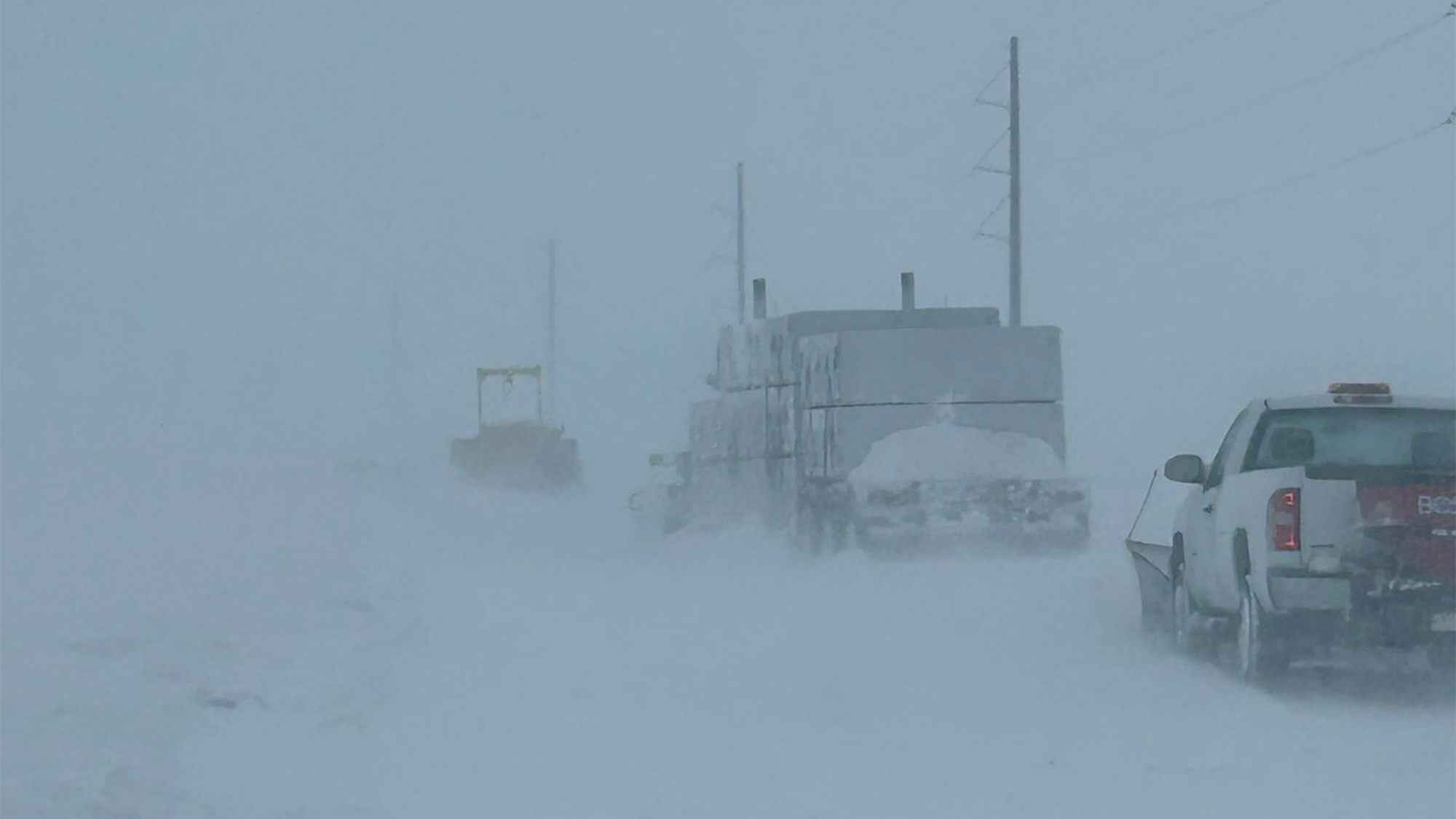
Radar showing snow falling in and around the Seattle metro this morning.
The Pacific Northwest is facing its own brand of weather whiplash this Friday as an atmospheric river collides with a lingering chill.
Residents in the Seattle metro area woke up to a rare March surprise as rain transitioned into a slushy snow mix during the morning commute.
While ground temperatures remain relatively warm—limiting most accumulations to the grass and higher elevations above 500 feet—the storms is providing just enough moisture to coat the Emerald City in a white, wintry film before transitioning back to a cold rain by this afternoon.
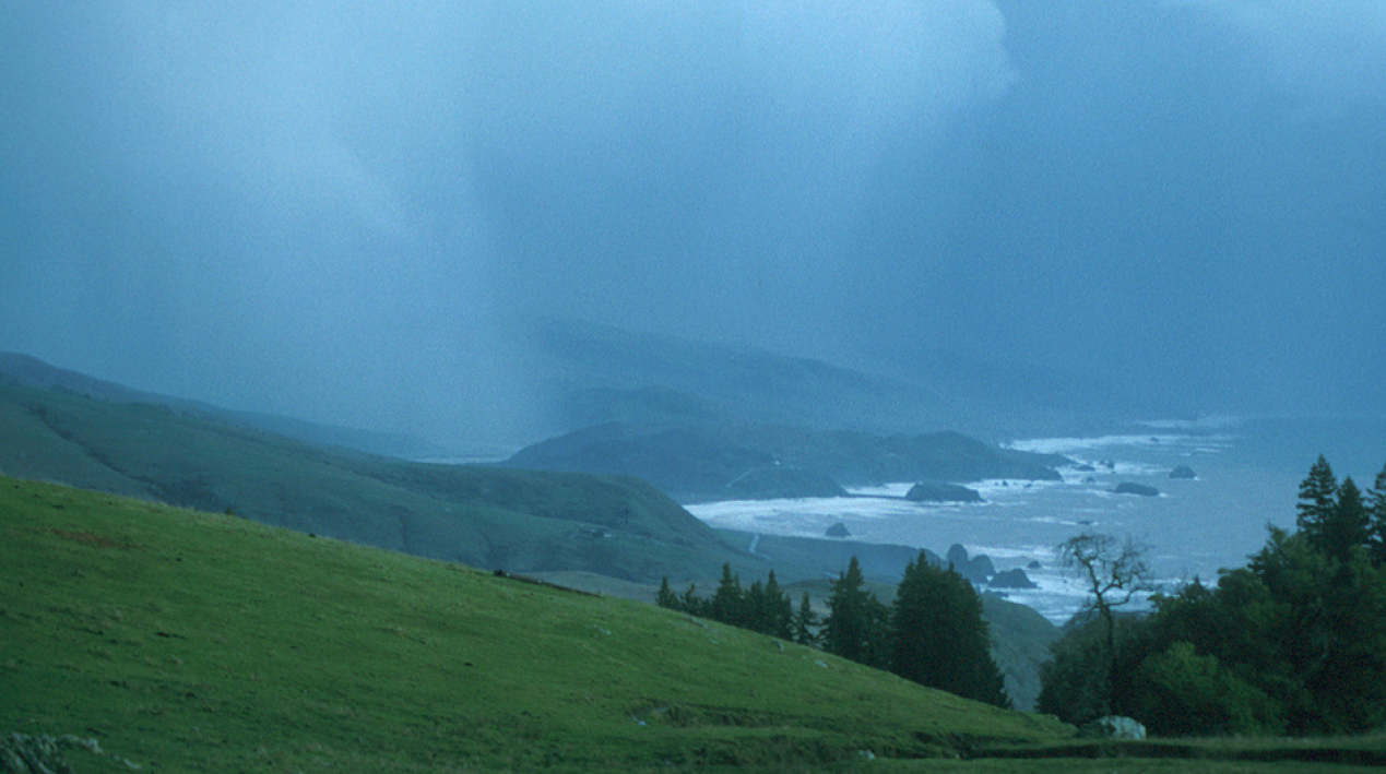
The real story, however, is unfolding in the mountains where the moisture from the atmospheric river is being wrung out as heavy snow.
Winter Storm Warnings remain in effect for the Cascades and Olympics, with several feet of new accumulation expected to bury mountain passes through Saturday morning.
While the lowland slush will likely vanish by lunch as temperatures climb into the 40s, the combination of high winds and intense snowfall in the high country continues to make travel hazardous across the I-90 and Stevens Pass corridors.
While the Midwest battles blizzards, a potentially historic heat wave is beginning to bake the Southwest and Southern California.
A dominant ridge of high pressure parked over the West Coast is expected to persist through next week, pushing temperatures 20–30°F above seasonal averages.
This prolonged stretch of dry, sunny weather puts more than 100 record highs at risk, with major metros like Los Angeles, Las Vegas, and Phoenix bracing for several consecutive days of unprecedented warmth for this time of year.
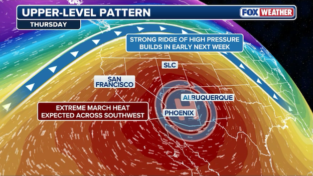
A "heat dome" is expected to bake the Southwest U.S. in record-setting heat next week.
The intensity of this heat could set new benchmarks as early as Tuesday, with Phoenix eyeing its earliest 100°F day on record. If the mercury hits triple digits, it would shatter the previous record set on March 26, 1988, by nearly two weeks.
Las Vegas is also on track to potentially eclipse its warmest March temperature ever recorded as highs climb into the mid-to-upper 90s.
With long-range outlooks keeping the West well above average through early April, this early-season heat dome marks a dramatic start to the spring season.
Once the massive March storm clears the Great Lakes early next week, a bitter blast of Arctic air will plunge much of the central and eastern U.S. back into a deep winter freeze.
By Tuesday, more than 230 million Americans are expected to experience below-average temperatures as strong northwesterly winds pull frigid air all the way from the Canadian border to the Texas-Mexico border.
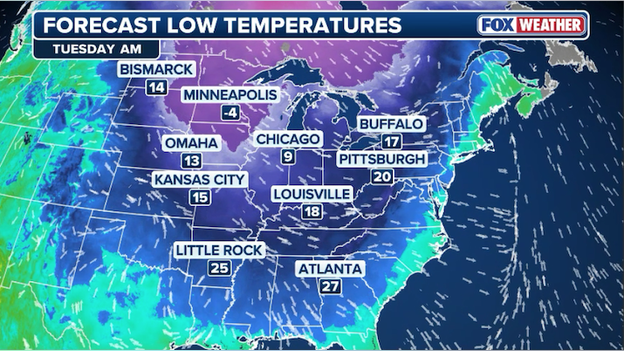
Tuesday morning low temperatures are forecast to dip into the single digits and teens throughout the Midwest and Great Lakes.
Highs in the Midwest will struggle to leave the teens and 20s, while cities like Minneapolis and Green Bay face wind chills dropping into the negative digits.
The cold will shift toward the East Coast by Wednesday, leaving cities from Atlanta to Washington, D.C., shivering with afternoon highs nearly 30 degrees below average.
Major Northeast hubs like New York City and Boston are forecast to wake up to temperatures in the upper teens and 20s as the record-breaking chill takes hold.
While this Arctic invasion will be a sharp shock following the weekend's storms, conditions are expected to slowly moderate and trend closer to seasonal averages by the end of next week.
A Winter Storm Warning has been issued for Minneapolis and surrounding communities as confidence increases in this weekend's winter storm.
Confidence is growing in a high-impact winter event as the National Weather Service has upgraded the Twin Cities to a Winter Storm Warning starting Saturday evening.
With the storm now less than 36 hours away, latest model guidance has solidified a track that places Minneapolis directly in the crosshairs of a major bomb cyclone.
Forecasters are now warning of historic potential, with 12 to 18 inches of heavy, wet snow likely for the metro area and localized totals potentially reaching up to two feet in western Wisconsin.
The primary concern for Minneapolis residents is the timing and intensity; snow is expected to fall at rates of 2–3 inches per hour Saturday night into Sunday morning, making travel nearly impossible.
When combined with 40 mph wind gusts on Sunday, the region will face prolonged periods of blowing snow and whiteout conditions.
Officials are urging everyone to complete their storm preparations by Saturday afternoon, as the heavy weight of the snow combined with high winds could lead to infrastructure damage and power outages that may last well into the Monday morning commute.
A powerful windstorm continues to impact air travel across the Northern Tier today, resulting in more than 2,200 flight delays nationwide, according to FlightAware.
Major aviation hubs, including Chicago O’Hare and Minneapolis-St. Paul, have been the most significantly affected as gusts of 60–70 mph create difficult operating conditions.
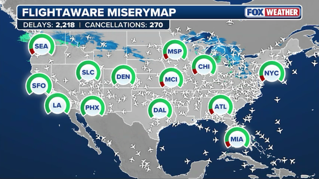
FlightAware MiseryMap showing nationwide flight disruptions at major hubs today.
The Federal Aviation Administration (FAA) recently implemented a ground stop for O’Hare to manage the flow of traffic safely during the peak of the wind event, leading to a steady increase in wait times for passengers across the region.
As the storm system moves eastward, the ripple effect of these morning delays is expected to persist throughout the afternoon and evening.
With a second, more significant blizzard forecast for the Great Lakes this weekend, travelers are encouraged to stay in close contact with their airlines and monitor flight status apps regularly for the most up-to-date information on their departures.
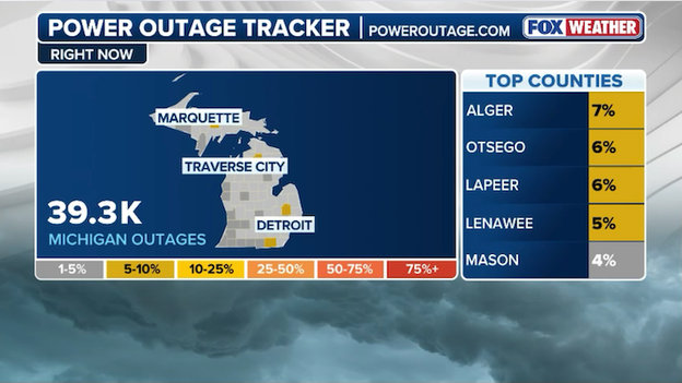
Nearly 40,000 customers are without power in Michigan this morning as high winds roar through the state.
Nearly 40,000 homes and businesses across Michigan are in the dark this morning as a powerful clipper system delivers a punishing blow to the state’s power grid.
High winds, with gusts reaching between 60 and 65 mph, have been snapping tree limbs and toppling utility lines from the shores of Lake Michigan to the Detroit metro area.
While utility crews have been staged across the state, the persistent nature of these 60 mph gusts is making restoration efforts difficult and dangerous.
Officials warn that as the windstorm continues through the afternoon, the number of outages could continue to climb before the weather finally calms this evening.
With a second, more powerful blizzard set to arrive on Sunday, residents are being urged to keep their devices charged and stay clear of any downed lines, which should always be treated as live and dangerous.
When meteorologists use the term "bomb cyclone," they are describing a process called bombogenesis—a rapid and violent drop in atmospheric pressure that signals a storm is essentially going into overdrive. To qualify, a storm’s central pressure must plummet by at least 24 millibars within 24 hours.
This weekend, a clash between record warmth in the South and frigid air diving out of Canada will provide the high-octane fuel needed for this system to "bomb out" directly over the Great Lakes.
A rapidly intensifying low will "bomb out" this weekend, dumping heavy snow on the Midwest while whipping up intense winds.
As the pressure drops, the atmosphere tries to balance itself by rushing air toward the center of the storm, creating the 60–70 mph wind gusts that turn heavy snow into a blinding, life-threatening blizzard.
This specific setup is particularly dangerous because the storm is stacking directly under a powerful dip in the jet stream, allowing it to move slower and dump more snow than a typical fast-moving clipper.
For the Midwest, this means that the wind won't just be a side effect; it will be a primary driver of the conditions, creating snow drifts several feet high and reducing visibility to near-zero for hours at a time.
This meteorological perfect storm is why the FOX Forecast Center is highlighting a rare threat for the region: an inland bomb cyclone that carries the punch of a winter hurricane.
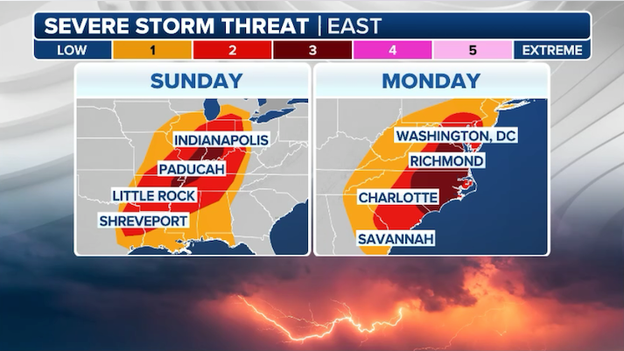
A multi-day severe weather outbreak is looming for nearly 100 million Americans on Sunday-Monday.
While a dangerous blizzard threatens the northern states, a different kind of hazard is brewing to the south. The FOX Forecast Center is tracking a widespread severe weather outbreak that targets more than 90 million people across a massive stretch of the country this Sunday and Monday.
As warm, moist air surges northward from the Gulf of America, it will collide with a powerful cold front, sparking everything from discrete supercells to intense lines of storms.
This setup puts major metropolitan areas from the Gulf Coast through the Ohio Valley on high alert for damaging wind gusts, large hail, and the potential for tornadoes.

The threat begins in earnest on Sunday as storms ignite across the Plains and Mississippi Valley before shifting eastward into the Tennessee Valley and Southeast on Monday.
Forecasters are particularly concerned about the "Conditional Intensity" of this setup, as any storms that manage to form in this high-energy environment could quickly become significant.
With over 90 million people in the path of this multi-day event, now is the time to review your severe weather plan, identify your safe room, and ensure your FOX Weather App alerts are turned on to keep you ahead of the storm.
While the Midwest is currently being hammered by a violent windstorm and clipper system, an even more powerful storm is already taking shape to bury the region under several feet of snow this weekend.
The FOX Forecast Center warns that this secondary bomb cyclone will arrive late Saturday and persist through Monday, cutting off any chance for a cleanup from today’s ongoing 70 mph gusts.
As this new system taps into a fresh surge of Arctic air from Canada, it is expected to rapidly intensify, transforming into a massive blizzard that could bring cities like Minneapolis, Green Bay, and Marquette to a total standstill.
The combination of several feet of fresh snow and wind gusts up to 70 mph will likely create life-threatening whiteout conditions and cripple travel across the Great Lakes.
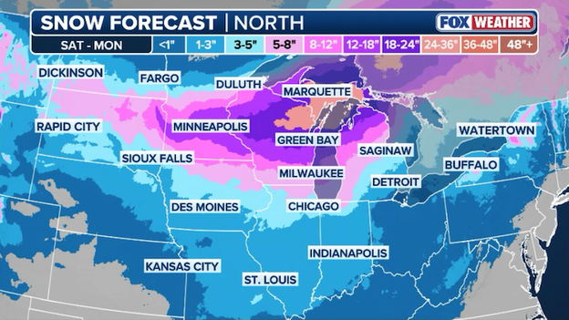
Latest snow forecast from FOX Weather showing where 2-3 feet of snow is expected through Monday.
While the heaviest snow targets central Wisconsin and northern Michigan, a dangerous wintry mix of freezing rain and sleet is forecast to slick the I-94 corridor near Milwaukee.
With Winter Storm Watches already in place, residents should prepare now for the potential of multi-day power outages and major disruptions to the Monday morning commute.
The same vicious winds that shredded the High Plains on Thursday are now roaring through the Northern Tier and Great Lakes, bringing hurricane-force intensity to the Midwest.
Yesterday's wind reports were nothing short of staggering, with Surprise Pinnacle, Wyoming, recording a top gust of 123 mph, while several locations across Montana and Wyoming clocked in well over 100 mph.
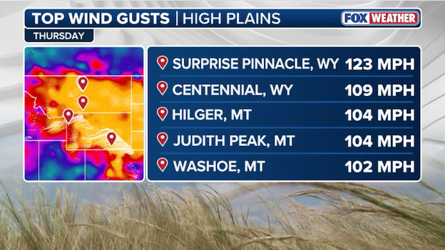
Wyoming recorded a 123 mph wind gust on Thursday.
As this powerful clipper system charges eastward today, that destructive energy is translating into 60-70 mph gusts for cities like Chicago and Minneapolis, where the combination of high winds and falling snow is creating dangerous whiteout conditions and widespread power outages.
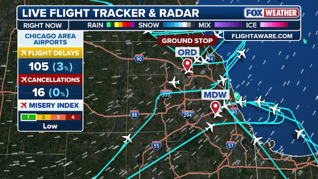
The Federal Aviation Administration issued a ground stop for Chicago O’Hare International Airport until 8:15 a.m. ET.
Air travel at one of the nation’s busiest hubs has hit a standstill this morning as the Federal Aviation Administration issued a ground stop for Chicago O’Hare International Airport.
The hold, which is currently in effect until 8:15 a.m. ET, was triggered by the same powerful windstorm that is currently lashing the Midwest with gusts of up to 60 mph.
These intense crosswinds make takeoffs and landings hazardous, forcing controllers to keep inbound flights at their departure cities to avoid congestion and safety risks on the runways.
While the ground stop is currently short-term, travelers should expect a significant ripple effect of delays and potential cancellations throughout the morning.
Even after the official hold is lifted, the one-two punch of high winds and lake-effect snow will likely continue to slow operations at both O'Hare and Midway.

If you are heading to the airport or picking someone up, experts recommend checking your flight status frequently as airlines work to stabilize their schedules against the relentless March clipper.
A powerful clipper system is charging across the Great Lakes this morning, bringing a dangerous combination of high winds and blinding snow that is already bringing travel to a halt.
While the High Plains saw staggering gusts over 100 mph yesterday, the core of the storm is now focused on cities like Chicago, Minneapolis, and Milwaukee, where 60 to 70 mph winds are toppling trees and knocking out power for thousands.
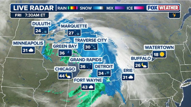
A powerful clipper is roaring through the Great Lakes this morning with high winds, rain, and snow.
This intense weather is creating a whiteout effect in areas under Blizzard Warnings, especially along the Lake Superior shoreline, where over a foot of snow could pile up by the end of the day.
The fast-moving storm will shift its peak intensity into the Ohio Valley and central Appalachians through this morning, bringing 60 mph gusts to cities like Columbus and Pittsburgh.
Because this system is fueled by a sharp clash between Arctic air and a deepening low-pressure center, the winds are strong enough to create dangerous crosswinds on major highways and widespread outages that may last into the weekend.
Even as the snow moves into New England this afternoon, blustery conditions and plummeting temperatures will stick around, making for a frigid and gusty start to the weekend across the eastern third of the country.
Latest power outage tracker showing widespread outages throughout the Midwest. (PowerOutage.com)
Thousands of residents across the Midwest are waking up in the dark this morning as a ferocious windstorm lashing Chicago and Minneapolis topples power lines and snaps tree limbs.
With peak gusts clocking in between 60 and 70 mph, utility crews are struggling to restore service amidst hazardous conditions that make it unsafe to deploy bucket trucks.
These widespread outages are creating a chaotic start to the day for tens of thousands of customers, particularly as temperatures begin to plummet behind the initial wind front.
You’ve reached the beginning of this live coverage.