Live updates: Dangerous storms to lash Illinois, Ohio, Indiana with huge hail, tornado threat
Live updates: Dangerous storms to lash Illinois, Ohio, Indiana with huge hail, tornado threat
Download the AppCoverage for this event has ended.
A Flash Flood Warning has been issued for Pittsburgh, Monroeville, and West Mifflin in Allegheny County until 12:45 AM EDT.
Repeated rounds of heavy rain have soaked the Steel City, triggering the warning as water begins to overwhelm drainage in parts of the area.
Meanwhile, severe storms continue to sweep across the Ohio River Valley, bringing torrential rainfall, damaging winds, and a growing number of damage reports across the region.
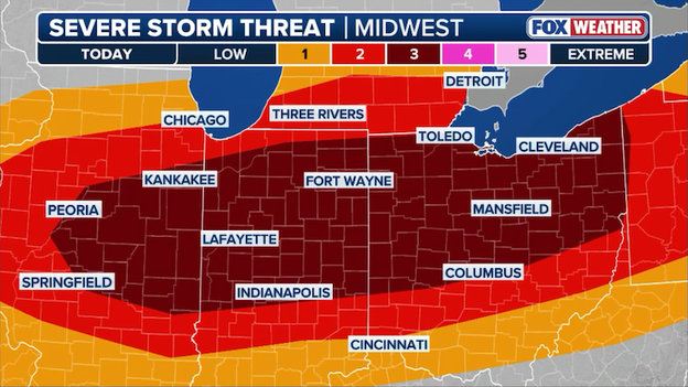
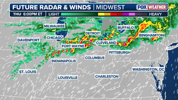
Over the past six hours, a volatile line of severe storms has torn across the Midwest and Ohio River Valley, unleashing destructive wind gusts and large hail from Illinois to Pennsylvania — with the threat far from over as storms continue pushing into the night.
Reports of damage are rapidly coming in as these storms leave a trail of impact across multiple states.
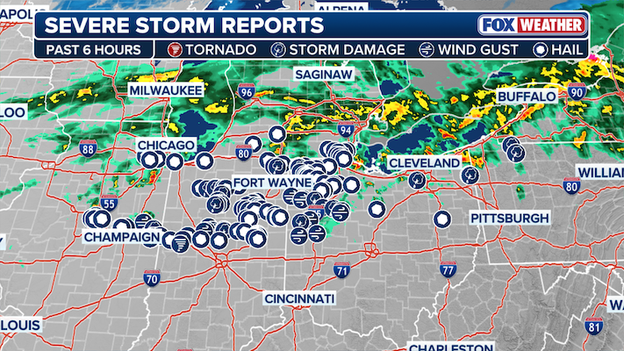
Severe Storm Reports over the past six hours
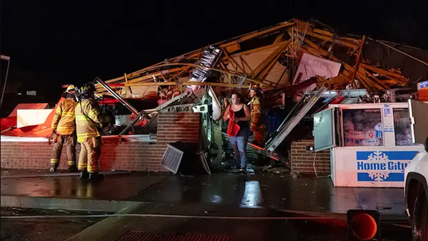
In Goldsmith, Indiana, powerful winds ripped the roof off a garage and knocked down a nearby fence, with additional reports of downed trees and damaged utility poles in the area.
In Kenton, Ohio, severe thunderstorm winds sent a metal roof flying onto U.S. Route 68, creating a dangerous situation for drivers.
And in McGuffey, strong winds tore the roof off a pre-fabricated shed.
This is an evolving situation.
Stay with FOX Weather as we track these storms and bring you the latest developments through the night.
Top hail reports from today's severe storms are in. Golf ball sized hail is flying across the Ohio River Valley, as 1.75" hail has been reported across parts of Ohio and Illinois.
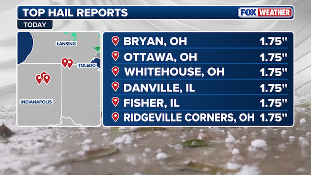
Top Hail Reports
It may sound like loose change, but even quarter-sized hail can pack a serious punch. As storms sweep the Ohio River Valley, FOX Weather Meteorologist Kiyana Lewis breaks down the hail scale.
FOX Weather Meteorologist Steve Bender analyzes the ongoing severe storms lashing the Ohio River Valley.
Blowing dust is creating dangerous travel conditions across parts of Illinois this evening as strong winds surge in behind a cold front.
According to the National Weather Service in Lincoln, wind gusts up to 45 mph are kicking up dust and reducing visibility to near zero in some areas.
A Blowing Dust Advisory is in effect for impacted counties across much of Central Illinois through 9 p.m. local time. Drivers are urged to use extreme caution, as visibility can rapidly deteriorate, creating life-threatening travel conditions in a matter of seconds.
A Blowing Dust Advisory is issued when strong winds lift loose, dry soil into the air, significantly reducing visibility and creating hazardous travel conditions.
These advisories are most common in open, rural areas where fields or dry ground can easily be picked up by gusty winds—typically behind a cold front.
Wind gusts of 30 to 45 mph or higher can loft dust high enough to create sudden, near-zero visibility, especially on highways.

A Severe Thunderstorm Watch has been issued for 7.7 million Americans across parts of Illinois, Indiana and Iowa until 11 PM CDT.
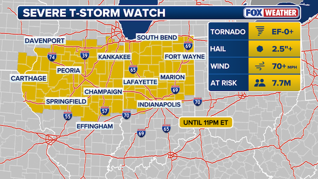
Severe Thunderstorm Watch map
After a relentless March of volatile weather, this region is once again in the crosshairs. The atmosphere is primed, and storms could quickly turn dangerous with damaging winds, large hail, and intense lightning.
Stick with FOX Weather as we continue to track this developing severe weather threat.
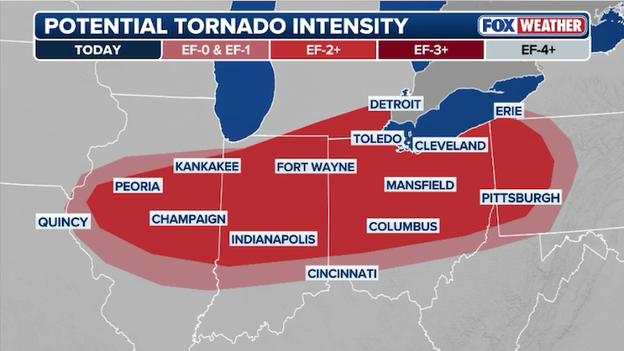
The first Tornado Watch of today’s severe weather event has been issued for parts of Ohio, Pennsylvania, and West Virginia, and remains in effect until 11 p.m. EDT tonight.
This watch signals the potential for EF-1 or stronger tornadoes, hail larger than 2 inches in diameter, and damaging wind gusts in excess of 70 mph.
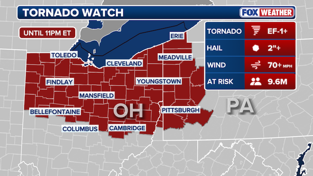
Tornado Watch map
More than 9 million people are under the watch as conditions rapidly become favorable for severe storm development through the evening.
Major cities included in the watch area are Toledo, Cleveland, and Pittsburgh, where storms are expected to develop and intensify in the coming hours.
The National Weather Service office in Pittsburgh is launching a weather balloon to get a real-time read on the atmosphere as severe storms take aim at the region today.
This special data collection comes as millions across the central and eastern U.S.—from Nebraska to Pennsylvania—brace for a widespread severe weather threat.
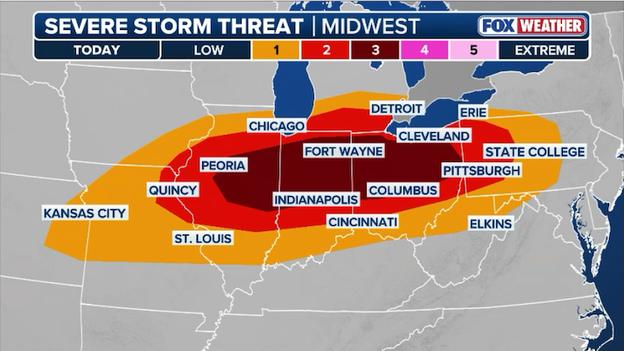
A level 3 out of 5 risk is in place from Indiana into Ohio, placing areas just west of Pittsburgh in a higher-impact zone. Meanwhile, Pittsburgh sits in a level 2 out of 5 risk, meaning strong to severe storms are still very much on the table.
The data collected by the weather balloon will track conditions as they evolve through the afternoon and evening on their approach to the western Pennsylvania area.
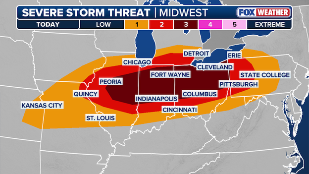
Severe Storm Threat
Weather balloons monitor the environment before weather events by providing a vertical profile of the atmosphere as they rise into the sky.
As they ascend, they measure temperature, humidity, pressure, and wind speed and direction, transmitting the data back in real time.
This information helps meteorologists assess key ingredients for severe weather, such as instability, wind shear, moisture depth, and lapse rates.
By analyzing these factors, forecasters can determine the potential for hazards like large hail, damaging winds, and tornadoes, and adjust forecasts and issue warnings based on actual atmospheric conditions rather than relying solely on models.
Tonight's severe storm threat is eyeing more of Illinois, Indiana, and Ohio. Storms are expected to develop by late afternoon, bringing the potential for significant hail and damaging wind gusts.
Over the next few hours, egg-sized hail, damaging winds, and tornadoes will be possible across portions of Illinois and Indiana, and into northwestern Ohio.
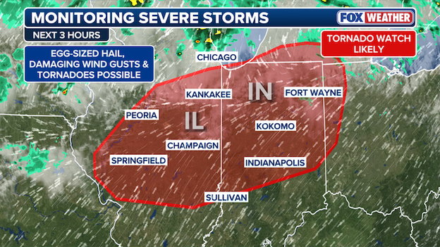
FOX Forecast Center is monitoring severe storms
Tornado Watches are likely as conditions continue to become more favorable for severe weather.
Ample daytime heating combined with warm, moisture-rich air from the Gulf of America will collide with an approaching cold, creating a strong convergence zone for storm development.
Hailstones larger than 2 inches in diameter are likely from central Missouri into far northern Ohio, including cities such as St. Louis, Chicago, Indianapolis, and Cleveland.
A few tornadoes cannot be ruled out, particularly along the northern edge of the severe weather zone where atmospheric dynamics will be most favorable.
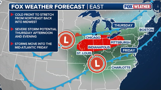
By evening, storms are expected to organize into a line stretching roughly from Kansas City to Pittsburgh.
At that point, damaging winds—potentially exceeding 65 mph—will become the primary threat. This line of storms will surge southeast overnight, continuing to produce active weather as it moves into the Mid-Atlantic.
While today’s primary headlines focus on the wind and tornado risk, the FOX Forecast Center is also monitoring a growing threat for flash flooding as heavy rain moves through the Ohio Valley.
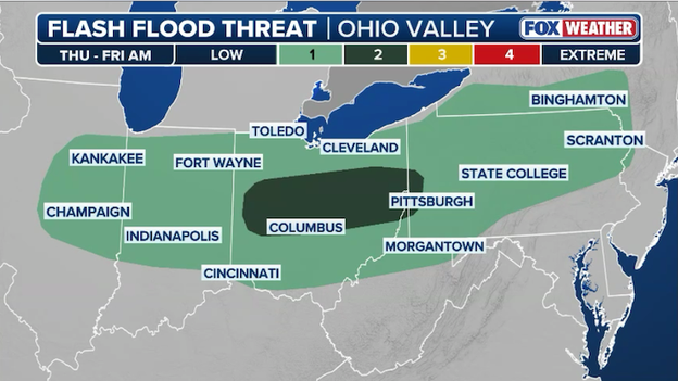
Heavy rain could trigger flash flooding from Illinois to Pennsylvania through early Friday morning.
Because the cold front is expected to stall slightly as it sags southward, multiple rounds of storms may move over the same saturated ground—a process meteorologists call training.
In areas from east-central Ohio into western Pennsylvania and West Virginia, rain rates could reach 1 to 2 inches per hour within the most intense storm clusters.
This is more than enough to overwhelm storm drains and cause rapid rises in creeks and small streams, particularly in urban areas and steep terrain where runoff happens quickly.

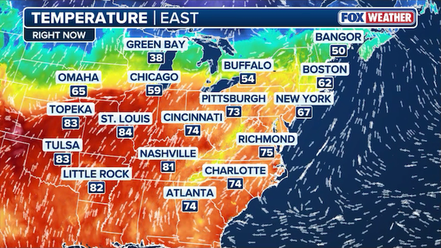
Temperatures are soaring into the 70s and 80s ahead of a cold front that will help spark severe weather later today.
Today’s severe weather is being powered by a dramatic clash of seasons as record-breaking heat in the 80s and 90s collides with a surging Arctic cold front across the Midwest.
This extreme temperature gradient acts as an atmospheric engine, forcing the volatile, warm air to rise rapidly and providing the raw fuel necessary for explosive supercell development.
As this powerful front crashes into the unusual warmth this afternoon, it will trigger a dangerous line of storms capable of producing giant hail and tornadoes before ushering in a 50-degree flashback freeze by Friday morning.
A high-stakes weather setup is quietly unfolding behind the scenes across the Midwest and Ohio Valley, even as many regions enjoy a deceptively calm afternoon.
Think of the atmosphere today as a loaded spring held back by a cap—a layer of warm air aloft acting as a lid that is currently suppressing a surge of intense heat and moisture.
As we reach the peak of afternoon heating, that lid is expected to pop, triggering an explosive transition from sunshine to severe thunderstorms in a matter of minutes.
A powerful weather disturbance is moving quickly out of the Rockies and toward the Great Lakes, acting as the spark for this system. At the same time, a cold front is pushing south, colliding with warm air and moisture surging up from the Gulf.
This collision creates a narrow corridor of concern stretching from central Illinois through Indiana and Ohio into western Pennsylvania.
Because the winds high above us are moving at incredible speeds—up to 75 mph—any storm that manages to break through the cap will have the fuel and the spin it needs to become dangerous almost instantly.
Severe thunderstorms are forecast to erupt across the Midwest and Ohio Valley later this afternoon.
What to expect: From giant hail to destructive winds
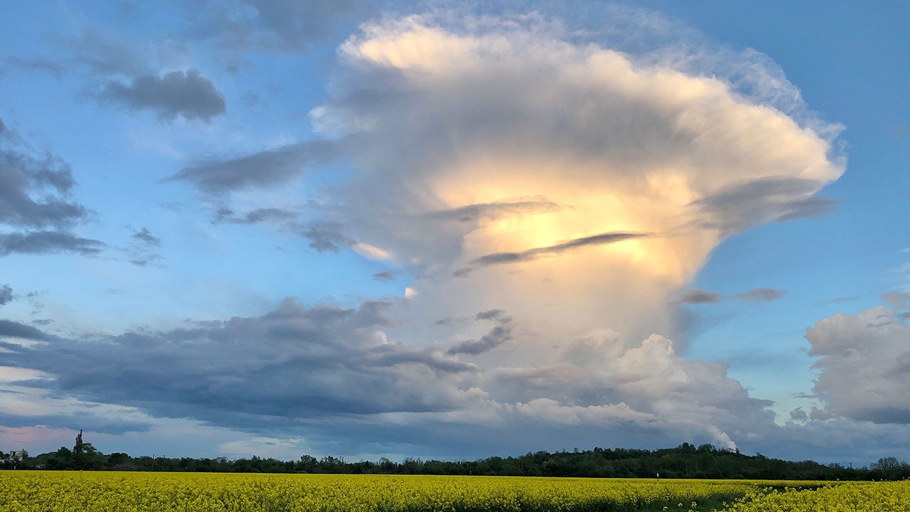
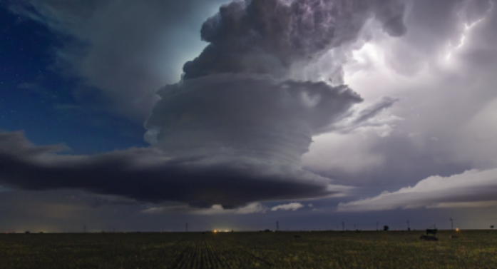
The first storms are expected to fire up between 3:00 p.m. and 6:00 p.m. local time. Initially, these will likely be individual supercells—the most intense type of storm—which are notorious for producing large to very large hail and isolated tornadoes.
If these storms can stay separate from one another, the risk for significant property and vehicle damage from ice increases.
As the evening progresses, these individual storms are expected to clump together into a fast-moving line.
When this happens, the threat shifts from hail to damaging straight-line winds. Some gusts could exceed 75 mph, which is equivalent to hurricane-force strength.
This line will race through the Ohio Valley and into Pennsylvania through the late evening, meaning you need to have FOX Weather App alerts enabled even after the sun goes down.
While much of the Midwest is on alert for large hail, the FOX Forecast Center is closely monitoring a specific corridor where the atmosphere is primed for strong tornadoes.
This risk is most concentrated along the northern extent of the storm system, stretching from central and northern Illinois through northern Indiana, southern Michigan, and across Ohio into western Pennsylvania.
The FOX Forecast Center says a couple strong tornadoes are possible later this afternoon-evening across the Midwest.
In these areas, the ingredients for a tornado—moisture, instability, and wind shear—are coming together in a way that could support rotating supercells capable of spinning up a tornado that could stay on the ground for an extended period.
The primary driver for this tornado threat is a powerful low-pressure system pulling spin into the lower levels of the atmosphere.
As the afternoon cap breaks, storms will tap into this twisting wind, particularly in the I-80 and I-90 corridors.
While the threat begins with individual cells in Illinois and Indiana mid-afternoon, the risk remains heightened as the system tracks eastward toward Cleveland and Pittsburgh through the evening.
Residents in these areas should ensure their FOX Weather alerts are turned up loud, as the rapid nature of these storms means warnings may be issued with very little lead time before a tornado develops.
While March is making a quiet exit for some, the FOX Forecast Center is already looking ahead to a volatile start to April.
The historic heat dome that has dominated the country is finally expected to break down this Sunday and shift eastward.
This shift is a game-changer; it opens the door for powerful Pacific storms to move inland and strengthen.
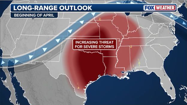
The FOX Forecast Center says severe storm chances will increase during the opening days of April.
As we head into April 1–2, a significant zone stretching from the Plains to the Mississippi Valley will be in the crosshairs for a new round of severe weather.
This transition is a classic spring setup. Cooler air surging out of the West is slated to collide with warm, moisture-rich air sitting over the central U.S., creating the perfect ingredients for severe thunderstorms.
While it is too early for specific storm outlooks, the signals are clear: an active and potentially dangerous pattern is returning.
This aligns with historical trends, as April is the second-most active month for tornadoes in the U.S., averaging 197 nationwide. Texas typically leads the charge with an average of 25 tornadoes in April, followed closely by Mississippi and Alabama, which each average 16.
While the focus today is on the severe storm threat, the grand finale of this weather system is a dramatic and punishing temperature drop that the FOX Forecast Center is calling a "flashback freeze."
As the powerful cold front slices through the Midwest and Ohio Valley this evening, it will replace record-breaking afternoon warmth with a surge of Arctic air. In cities like Chicago, Indianapolis, and Detroit, temperatures that peaked in the 70s and 80s this afternoon will crater behind the storm line.
Temperatures are forecast to dip below freezing on Friday morning after a cold front sweeps through the Midwest.
This isn't a gradual cool-down; we are tracking a rapid plunge where values could drop 20 to 30 degrees in as little as one hour immediately following the rain.
By Friday morning, the spring-like air will be a distant memory as lows bottom out in the 20s and 30s across the Great Lakes and Mid-Mississippi Valley.
This represents a total 24-hour temperature swing of nearly 50 degrees for some communities. The transition will be so sharp that any lingering moisture behind the front could briefly turn into a few flurries or light snow showers before the air dries out.
If you’ve already started your spring planting or moved sensitive pots outdoors, you need to take action now to protect them. You’ll go from running the AC during the storms this afternoon to cranking up the furnace by the time you wake up tomorrow.
The FOX Forecast Center is tracking a significant threat for huge hail—stones exceeding 2 inches in diameter—across central Illinois, Indiana, and northern Ohio this afternoon.
These storms are being fueled by intense daytime heating that will eventually erode the atmospheric cap, allowing air to surge upward at explosive speeds into a high-energy environment.
With strong wind flow reaching 60 mph or more in the upper atmosphere, these storms are likely to form as organized supercells.
These rotating updrafts act like a powerful vacuum, suspending moisture in the freezing layers of the storm long enough for massive layers of ice to build up, potentially producing hailstones the size of eggs or tennis balls that can easily shatter windshields and damage property.
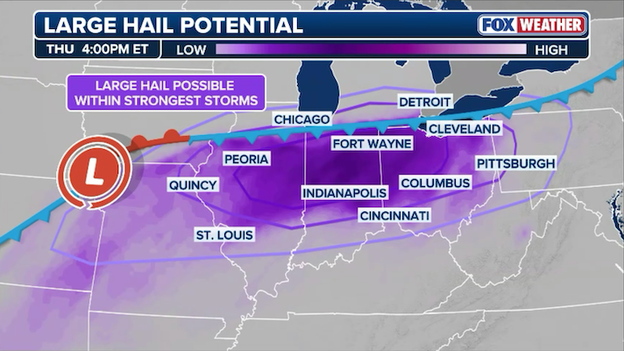
Severe thunderstorms could produce huge hail across Illinois, Indiana, and Ohio through the evening hours.
The window for this huge hail threat is expected to be highest during the initial storm development between 2:00 p.m. and 6:00 p.m. local time, specifically targeting a corridor from Springfield, Illinois, through Indianapolis, and over to Cleveland.
While these individual supercells will eventually congeal into a solid line—shifting the primary threat from hail to damaging straight-line winds—the early-evening period remains the most volatile for significant ice.
If you have a vehicle or outdoor equipment in these areas, now is the time to secure them under a sturdy roof before the atmosphere pops and these high-impact storms begin their trek across the Ohio Valley.
For communities in Kankakee County, Illinois, and across the state line into Northwest Indiana, today’s severe weather threat isn’t just a forecast—it’s a haunting reminder of the destruction that struck just over two weeks ago.
LAKE VILLAGE, INDIANA - MARCH 10: An employee emerges after being rescued from a Family Dollar store destroyed by a tornado on March 10, 2026 in Lake Village, Indiana. The National Weather Service had issued an urgent warning about a large tornado moving through the area, calling it a "life-threatening situation." (Photo by Michael Hickey/Getty Images)
On March 10, a powerful EF-3 tornado packing 160 mph winds tore a 35-mile path through the region, leveling homes in Aroma Park, destroying businesses, and tragically claiming lives as it tracked into Lake Village, Indiana.
As families continue to clear debris and navigate the early stages of insurance claims, the FOX Forecast Center warns that these same vulnerable areas are back in the crosshairs of a Level 3 out of 5 severe risk.
With the atmosphere primed for giant hail and more tornadoes before a dramatic freeze tonight, the psychological toll is high for residents who are once again forced to seek shelter among the ruins of their neighborhoods.
Today’s severe weather threat is a waiting game that centers on a late-afternoon breakout. While a capping inversion is keeping the skies relatively clear for much of the morning and early afternoon, this atmospheric lid is expected to fail between 3:00 p.m. and 5:00 p.m. local time.
As the cold front pushes into the record-warmth and moisture surging up from the Gulf, storms will ignite rapidly from eastern Illinois into Indiana and northern Ohio.
Residents in Chicago, Indianapolis, and Detroit should be prepared for a very sudden transition from sunshine to severe thunderstorms just as the evening commute begins.
Severe storms are expected to develop late this afternoon and into the evening across the Midwest and Ohio Valley.
As we move into the evening and overnight hours, the individual storm cells are forecast to organize into a fast-moving, cohesive line.
By 8:00 p.m. to 10:00 p.m., this line will stretch from roughly Kansas City to Pittsburgh, shifting the primary threat from giant hail to damaging straight-line winds.
These storms won't quit when the sun goes down; they are expected to rumble through the Ohio Valley and into the Mid-Atlantic overnight, finally clearing the coast by Friday morning.
Behind this line, the flashback freeze begins immediately, with temperatures crashing 30 to 50 degrees in just a few hours.
If you’re looking out the window in Chicago or Indianapolis right now, you might see plenty of sunshine and feel unseasonably warm air. It feels like a beautiful spring day, but to a meteorologist, this is the calm before the storm—quite literally.
The atmosphere is currently under what we call a cap, and it’s the only thing keeping severe weather at bay for the moment.
Think of the cap like a lid on a pot of boiling water. Right now, the sun is heating the ground, and warm, moist air from the Gulf of America is surging in at the surface.
This creates a massive amount of energy (or instability), but that energy is trapped. A layer of even warmer air a few thousand feet above our heads is acting as that lid, preventing the air at the surface from rising. As long as that lid stays on, storms cannot form. But the longer the lid stays on, the more pressure builds underneath it.
The breakout: From 0 to 60 in minutes
As we head into the late afternoon, two things will happen to break the cap. First, the afternoon sun will continue to bake the ground, making the surface air so buoyant that it eventually punches through the lid.
Second, a powerful cold front is arriving from the west, acting like a giant wedge that physically forces that warm air upward.
When that cap finally fails, the transition is often explosive. The FOX Forecast Center says it’s like taking the lid off that boiling pot: all that pent-up energy is released at once, and you can see a tiny cloud turn into a 40,000-foot-tall severe thunderstorm in a matter of minutes.
Because the energy has been building all day, the storms that break through will have immediate access to all that fuel. This is why we are concerned about significant hail (larger than 2 inches) and a few tornadoes the moment these storms initiate.
A cold front slamming into warm, humid air will help trigger the development of severe thunderstorms later today.
What this means for you
- Watch the sky: Once the first storms fire—likely after 3:00 or 4:00 p.m.—they will grow rapidly.
- Commuter alert: The timing of the cap break aligns perfectly with the evening rush hour for much of the Ohio Valley.
- Don't be fooled: Just because it’s sunny now doesn't mean the threat has passed. In fact, the more sun we see this afternoon, the more fuel will be available when the storms finally erupt.
Severe weather is expected today across the Midwest and Ohio Valley as a Level 3 out of 5 threat targets nearly 50 million people, including those in Chicago, Indianapolis, and Cleveland.
Severe thunderstorms are expected across the Midwest and Ohio Valley later today.
While an atmospheric "cap" is expected to hold storms at bay through much of the day, intense daytime heating and a surge of moist air from the Gulf will collide with an advancing cold front by late afternoon, triggering explosive thunderstorm development.
These volatile storms will be capable of producing giant hail exceeding 2 inches in diameter, damaging wind gusts over 60 mph, and a few strong tornadoes—particularly along the northern edge of the system—before congealing into a dangerous line that will race toward the Mid-Atlantic overnight.
Following this severe threat, residents should prepare for a dramatic flashback freeze as temperatures are forecast to plummet 30 to 50 degrees by Friday morning, potentially bringing a brief transition to light snow in the storms' wake.
You’ve reached the beginning of this live coverage.