Recap: Dangerous storms blast Oklahoma, Texas with tornadoes and huge hail
Recap: Dangerous storms blast Oklahoma, Texas with tornadoes and huge hail
Download the AppDangerous storms slam the Central U.S. in multi-day severe weather outbreak
View postCoverage for this event has ended.
Emergency crews are responding to reports of damage across North Texas at this hour, and we're monitoring the latest from officials as storms continue to slam the region.
Even though our live blog is pausing, you can stay ahead of the next round of storms by downloading the FOX Weather App. It is your best tool for:
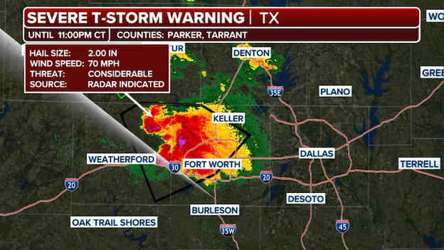
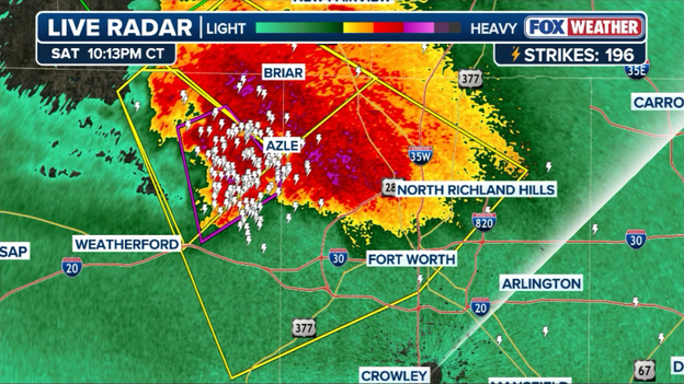
Radar showing a dangerous severe thunderstorms barreling into Fort Worth, Texas.
A nasty supercell is currently bearing down on Fort Worth, and while there are no active Tornado Warnings for the city at this exact moment, the storm remains a top-tier threat.
The FOX Forecast Center is tracking the storm, and the National Weather Service has maintained a Severe Thunderstorm Warning due to the high probability of 70 mph winds and golf ball-size hail.
Power outages are climbing rapidly across North Texas as violent storms, including a reported tornado in Runaway Bay, hammered the electrical grid.
Wise County has been particularly hard hit, with thousands of customers losing electricity as the storm's core snapped poles and downed lines.
Emergency crews from multiple jurisdictions have rushed to Runaway Bay, Texas tonight after a reported tornado left a trail of significant destruction across the western portion of the community
A Texas Department of Transportation camera in Azle is currently capturing the raw power of the storm as it slams the city with dangerous, straight-line winds and torrential rain that has reduced visibility to near zero.
The live feed shows the camera shaking violently under the force of the gusty winds while floodwaters begin to pool on local roadways, underscoring the immediate hazard to anyone still out on the roads in western Tarrant County.
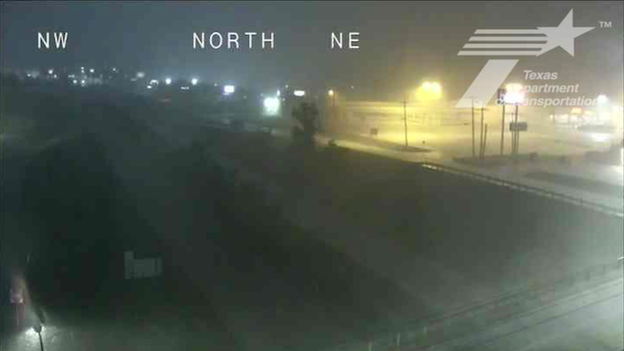
Texas Department of Transportation camera in Azle
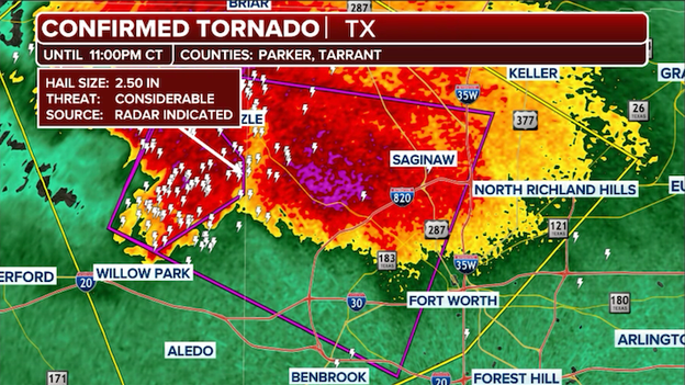
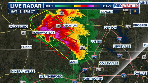
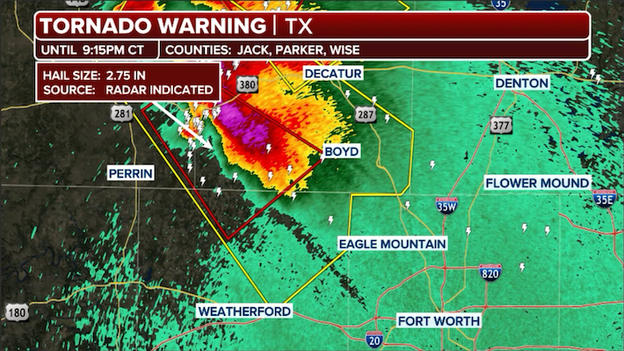
The National Weather Service has issued a Particularly Dangerous Situation (PDS) Tornado Warning for Parker and Tarrant Counties.
The National Weather Service has issued a Particularly Dangerous Situation (PDS) Tornado Warning for Parker and Tarrant Counties, placing the western suburbs of Fort Worth in the direct path of a large and extremely dangerous tornado.
This life-threatening storm is currently tracking toward the metro area, with radar and visual reports confirming a violent tornado on the ground.
The PDS tag is reserved for the most significant threats, indicating a high certainty of catastrophic damage to anyone in the storm's path.
If you are in White Settlement, Lake Worth, Azle, or Benbrook, you must move to your tornado shelter immediately.
This is not a situation to take lightly—this confirmed tornado is moving into a densely populated area and is accompanied by baseball-sized hail and destructive winds. Do not wait to see or hear the tornado; seek shelter in a basement or an interior room on the lowest floor of a sturdy building now.
Radar showing a Severe Thunderstorm Warning in effect for Fort Worth, Texas.
The National Weather Service has issued a Severe Thunderstorm Warning with a "destructive" tag for Fort Worth and surrounding areas in Tarrant County.
This is the highest tier of thunderstorm warning, reserved for storms packing life-threatening 80 mph wind gusts and baseball-size hail.
As this violent line of storms moves directly into the metropolitan area, the risk for significant damage to homes, vehicles, and power infrastructure is extremely high.
People living there must treat this with the same urgency as a Tornado Warning—move to the lowest floor of a sturdy building, stay in an interior room, and stay away from windows.
These 80 mph winds are capable of downing large trees and causing structural failure, while baseball-size hail can easily penetrate roofs and shatter glass. Seek shelter now and remain in your safe place until the storm core has passed.
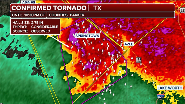
The National Weather Service has issued a Particularly Dangerous Situation (PDS) Tornado Warning for Parker County in Texas as a large and extremely dangerous tornado tears through the area.
The National Weather Service has issued a Particularly Dangerous Situation (PDS) Tornado Warning for Parker County in Texas as a large and extremely dangerous tornado tears through the area.
This life-threatening storm is currently tracking through the heart of the county, with radar and visual reports indicating a violent tornado moving near Springtown and Weatherford.
This specific PDS designation signifies a heightened risk to life and property, reserved for confirmed tornadoes that are likely to cause significant destruction.
If you are in Parker County, specifically in Weatherford, Springtown, or Azle, you must seek shelter immediately. This is a life-or-death situation—move to a basement, storm cellar, or the innermost room on the lowest floor of a sturdy building.
Wrap yourself in blankets or use a helmet to protect your head from flying debris. Do not wait for sirens or visual confirmation; the storm is moving toward the western edges of the DFW Metroplex, and every second counts.
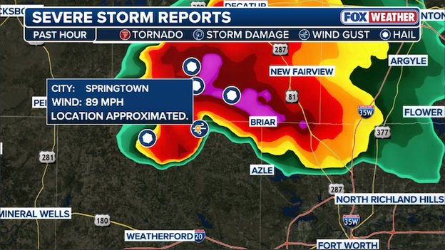
Amateur radio operators reported an 89 mph wind gust near Springtown, Texas.
The sheer power of tonight's Texas supercell was underscored by a massive 89 mph wind gust recorded near Springtown, Texas, as the storm's core blasted through Parker County.
This hurricane-force wind gust is capable of downing large trees, snapping utility poles, and causing significant structural damage to homes and outbuildings.
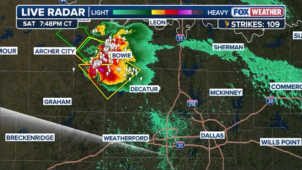
Radar image showing the intense supercell thunderstorm near Fort Worth, Texas.
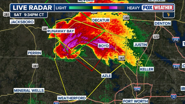
The FOX Forecast Center is closely monitoring a wild supercell northwest of the DFW Metroplex, which is exhibiting highly unusual movement.
While most storms in this environment are tracking southeast, this specific cell has shown a recent shift toward the south and even westward back-building tendencies near Runaway Bay.
This erratic behavior is often a sign of intense storm-scale dynamics as the cell interacts with localized outflow boundaries.
Despite its odd movement, the storm remains extremely dangerous, packing intense winds and huge hail.
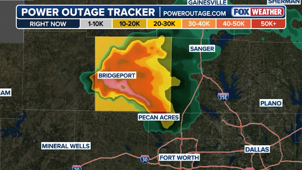
PowerOutage.com outage tracker across North Texas
Thousands of residents in Wise County are without power tonight after a reported tornado tore through Runaway Bay, Texas. Power outage numbers are still increasing as the storm hammers the county.
Radar showing where intense rain and huge hail are hammering parts of North Texas.
A dangerous supercell is gaining ground on the Dallas-Fort Worth Metroplex tonight, carrying a history of damage.
Just minutes ago, a tornado was reported on the ground in Runaway Bay, where power flashes illuminated the night sky, and the storm continues to produce baseball-sized hail capable of shattering windows and denting vehicles.
As this storm tracks southeast toward Tarrant and Denton Counties, the threat to life and property is intensifying.
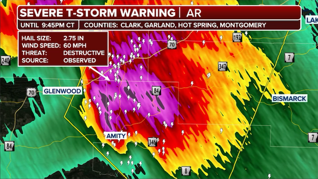
Radar showing an intense thunderstorm slamming Amity, Arkansas.
The National Weather Service has issued a Severe Thunderstorm Warning with a "destructive" tag for Amity, Arkansas, as a violent storm cell moves through the region.
This warning indicates that the storm is capable of producing baseball-sized hail and 60 mph winds, hazards that pose an immediate threat to life and can cause catastrophic damage to homes and vehicles.
Severe weather spotters have confirmed power flashes from a damaging tornado northwest of Fort Worth, Texas.
A life-threatening situation is occurring near Runaway Bay, Texas, where storm spotters have confirmed a tornado is currently moving through the area.
Bright power flashes have been spotted as the tornado impacts local infrastructure, providing a chilling visual of the damage occurring under the cover of darkness.
This confirms that a damaging tornado is on the ground and actively tearing through the community.
If you are in Runaway Bay, Bridgeport, or near Lake Bridgeport, you must be in your safe place immediately. These power flashes indicate the storm is directly hitting power lines and transformers, making it an extremely hazardous environment.
Stay away from windows, move to the lowest level of your home, and stay protected until the threat has passed.
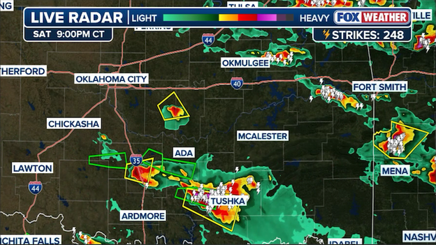
The FOX Forecast Center says the tornado threat is gradually diminishing across Oklahoma.
The immediate tornado threat across Oklahoma is beginning to fizzle as the initial wave of discrete supercells starts to lose its individual punch.
Forecasters note that the atmospheric setup is transitioning, with storms increasingly clumping together—a process that disrupts the tight, localized rotation needed to sustain tornadoes.
While this is a welcome development for those worried about twisters, the FOX Forecast Center remains on high alert.
As these storms merge, the danger isn't disappearing; it’s simply changing form. We are now monitoring for upscale growth, where these clusters will likely evolve into a powerful line capable of producing widespread damaging wind gusts and large hail.
Even as the tornado risk dips, stay weather-aware—late-night wind events can be just as destructive as isolated tornadoes.
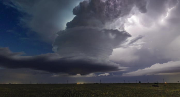
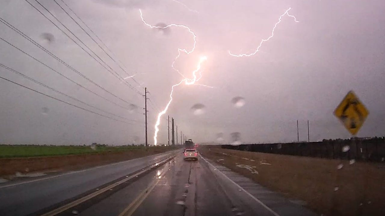
FOX Weather Exclusive Storm Tracker Mark Sudduth has captured a breathtaking image of the atmosphere's power, using a drone to photograph vivid lightning strikes illuminating the sky over the Dallas-Fort Worth Metroplex.
From his high-altitude vantage point, the photo reveals the massive scale of the electrical activity currently pulsing through the storm's anvil as it moves toward the heart of the city.
This unique perspective provides a bird's-eye view of the intense energy driving tonight's severe weather outbreak across North Texas.
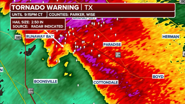
The FOX Forecast Center is closely tracking an intense supercell thunderstorm that is now barreling toward the Fort Worth area.
A new Tornado Warning has just been issued for Jack, Parker, and Wise Counties, placing the storm just 30 miles from downtown Fort Worth.
Radar showing an intense supercell thunderstorm charging toward Fort Worth, Texas.
This dangerous cell has already displayed significant low-level rotation and is the same system responsible for destructive wind and hail reports earlier this evening.
Residents in Fort Worth, Tarrant County, and the surrounding suburbs must take this threat seriously. With the storm moving southeast at a steady clip, now is the time to activate your severe weather plan.
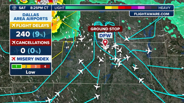
The Federal Aviation Administration issued a ground stop for Dallas-Fort Worth International Airport (DFW) until 10:30 p.m. ET.
Travel is coming to a screeching halt at Dallas-Fort Worth International Airport (DFW) as a ground stop has been issued due to the rapidly approaching severe thunderstorm.
The Federal Aviation Administration (FAA) took the measure as 70-mph winds and massive hail move toward the western Metroplex.
If you are scheduled to fly into Dallas tonight, be ready to wait, as these storms are expected to impact operations well into the overnight hours.
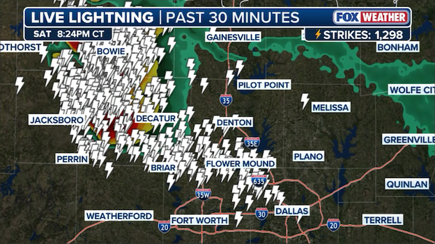
Map showing cloud-to-ground lightning strikes occurring well away from the supercell thunderstorm northwest of the Dallas-Fort Worth Metroplex.
A spectacular yet dangerous display is illuminating the sky over Dallas tonight, with lightning being produced from the massive anvil of a storm located over 50 miles away.
While the heart of the thunderstorm remains far to the west, these "bolts from the blue" originate in the upper reaches of the storm cloud and can travel incredible distances horizontally before striking the ground.
This serves as a critical reminder that you don't need to be in the rain to be at risk—if you can see the lightning or hear distant thunder, you are close enough to be struck.
Radar showing a destructive severe thunderstorm charging toward the Dallas-Fort Worth Metroplex.
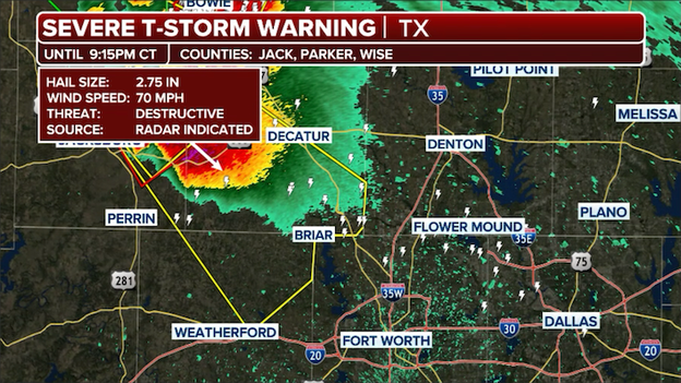
The National Weather Service has issued a Severe Thunderstorm Warning for Jack, Parker, and Wise Counties as a line of violent storms approaches the DFW Metroplex.
This particular warning carries a "destructive" tag due to the potential for 70 mph wind gusts and baseball-sized hail, which can cause significant damage to roofs, windows, and vehicles.
As these storms track southeast, residents in cities like Jacksboro, Weatherford, and Decatur should treat this with the same urgency as a Tornado Warning.
The combination of extreme wind and massive hail poses a serious threat to life and property. Move away from windows and ensure you are in a sturdy building as the core of this storm moves through.
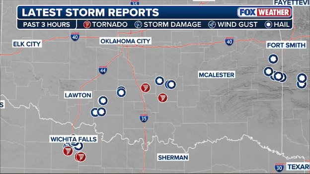
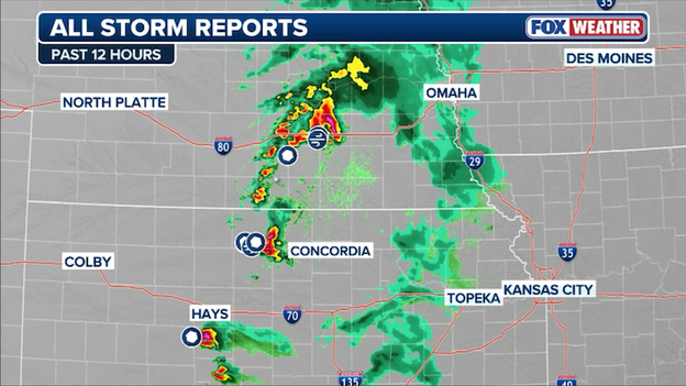
Storm reports of tornadoes, damaging winds, and large hail to the National Weather Service as of 9 p.m. ET.
As of this hour, the severe weather has already left a significant mark across the central United States, with 5 tornado reports and 45 combined reports of giant hail and damaging winds spanning 5 states.
These numbers tell the story of an incredibly volatile atmosphere that has turned particularly dangerous after sunset, with the most concentrated damage centered in parts of Texas and Oklahoma.
As storms continue to track eastward into the overnight hours, these totals are expected to rise, further highlighting the intensity of this multi-day weather event.
The FOX Forecast Center is closely tracking a dangerous, tornado-producing supercell as it inches closer to the heavily populated Dallas-Fort Worth Metroplex.
This is the same powerful storm that recently prompted a PDS Tornado Warning in Clay County and has a confirmed history of producing both tornadoes and massive, baseball-sized hail.
Radar showing a lone supercell tracking toward the northwest suburbs of the Dallas-Fort Worth Metroplex.
As the storm tracks southeast at approximately 20 mph, it is expected to approach the northwest side of the Metroplex—including areas like Denton, Gainesville, and McKinney—within the next hour.
While the storm may undergo changes as it moves into a slightly different environment, its history of violent rotation makes it a significant threat to the region.
If you are in the northern DFW suburbs, now is the time to review your severe weather plan and ensure your FOX Weather App is set to "always on" for emergency alerts.
Stay away from windows and be prepared to seek shelter immediately if a warning is issued for your specific neighborhood.
The FOX Forecast Center is observing a shift in storm behavior across Oklahoma as individual cells begin to cluster together and grow upscale.
While discrete, lone supercells are usually the primary producers of tornadoes, this clumping effect often disrupts the localized rotation needed to keep twisters on the ground, likely leading to a decrease in the immediate tornado threat.
FOX Weather meteorologists warn that the tornado threat has not ended, but because the storms are so close together, they're likely robbing each other of the necessary winds to spin up a powerful twister at this moment.
Doppler radar showing a cluster of thunderstorms in Oklahoma which could reduce the threat for intense tornadoes.
As the tornado threat intensifies across Oklahoma, FOX Weather is tracking a growing hazard on the ground: "chaser convergence."
Dozens of professional trackers, amateur enthusiasts, and curious onlookers have flooded the secondary roads and highways near today's active supercells, leading to significant traffic congestion.
While getting a glimpse of a tornado is the goal for many, experts say that these clogged corridors can become a major safety risk, potentially slowing down emergency responders and making it difficult for local residents to evacuate quickly.
If you are in the path of these storms, remember that the safest place is in your shelter—not on the road.
Avoid travel in the immediate vicinity of warned storms to ensure you don't become part of the gridlock when seconds count.
Dramatic video shared on Facebook by Klonie Berend provides chilling visual confirmation of the tornado spotted earlier this evening near Archer City, Texas.
The video shows a large, rotating funnel moving through the North Texas landscape, highlighting the immense power and immediate danger of this specific supercell.
This "ground truth" from social media confirms what radar has been indicating: a significant and life-threatening tornado is currently impacting the region.
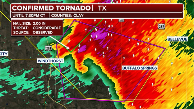
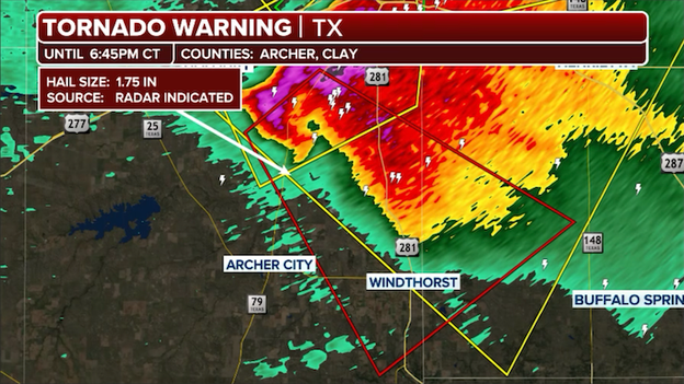
Radar shows the Tornado Warning and dangerous supercell in Clay County, Texas.
The National Weather Service has elevated the threat level to a Particularly Dangerous Situation (PDS) for Clay County, Texas, as a confirmed and highly dangerous tornado moves through the area.
This rare "PDS" tag is only used when there is a high degree of confidence that a damaging, potentially violent tornado is on the ground, posing an extraordinary threat to life and property.
If you are in Southern Lake Arrowhead, Shannon, and Joy, you must seek shelter immediately in a basement or an interior room on the lowest floor of a sturdy building.
This is not a situation to take lightly—this storm has a proven history of producing massive hail and a confirmed tornado, and it is now moving into your community.
Protect yourself from flying debris and stay in your safe place until the warning has expired.
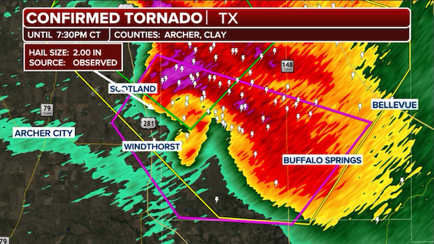
Emergency officials and severe weather spotters confirm a tornado is in progress near Windthorst, Texas.
A dangerous situation is unfolding in North Texas as a confirmed tornado is in progress near Windthorst.
This damaging storm was spotted by local officials and is currently tracking toward Clay County.
Radar signatures show intense low-level rotation alongside reports of massive, baseball-sized hail as this supercell moves through a highly volatile environment near the Red River.
If you are in the path of this storm, specifically in areas like Windthorst, Scotland, or Henrietta, you must take shelter immediately.
Move to the lowest floor of a sturdy building, stay in an interior room away from windows, and protect your head from flying debris.
Do not wait for visual confirmation—this is a life-threatening situation.
The FOX Forecast Center is warning of a relentless multi-day severe weather outbreak that will keep millions of Americans on high alert through early next week.
For the remainder of tonight, the focus remains on the southern Plains and Ark-La-Tex, where powerful supercells continue to pose a triple threat of strong tornadoes, damaging winds, and giant hail.
By Sunday, the severe threat shifts northward into the Central Plains, specifically targeting areas from Kansas and Missouri up to Nebraska and Iowa, where a deepening area of low pressure will trigger another round of intense storms capable of all severe modes.
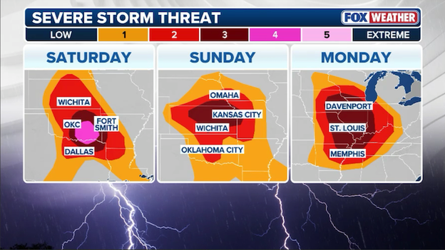
A multi-day severe weather outbreak is underway across the Central U.S. with tornadoes, huge hail, and damaging winds likely each day.
However, Monday is shaping up to be the most concerning day of the stretch; a significant severe weather outbreak is appearing increasingly likely across the Mid-Mississippi, Ohio, and Tennessee Valleys.
Forecasters are monitoring a potent atmospheric setup that could lead to widespread damaging winds and the potential for long-track, strong tornadoes as the system sweeps toward cities like St. Louis and Springfield.
Ensure you have the FOX Weather App alerts turned on, as this active spring pattern shows no signs of slowing down.
The National Weather Service has issued a Flash Flood Warning for Wichita Falls and portions of Wichita County.
The same powerful supercells that dropped baseball-sized hail earlier also dropped torrential rain, with rates high enough to quickly overwhelm drainage systems and low-water crossings.
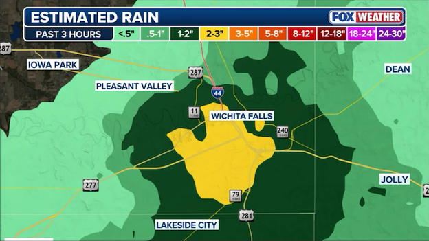
Doppler radar estimates more than 2 inches of rain fell in and around Wichita Falls, Texas within an hour.
If you are traveling in the area, be extremely cautious, especially at night when floodwaters are harder to see.
Most flash flood fatalities occur in vehicles, so if you encounter a flooded roadway, remember the life-saving rule: Turn around, Don't Drown.
While you are seeking shelter from the severe winds and hail, ensure you are not in a basement or low-lying area that is prone to rapid flooding.
A tornado has been spotted northeast of Archer City, Texas, as a powerful supercell continues to track through North Texas.
Local storm spotters have confirmed the sighting, which is occurring within the current Tornado Warning area for Archer and Clay Counties.
This follows radar signatures showing intense low-level rotation and earlier reports of 3-inch hail from the same dangerous cell.
If you are in the path of this storm, especially near Windthorst or Scotland, seek shelter in a basement or interior room immediately—stay away from windows and protect yourself from flying debris.
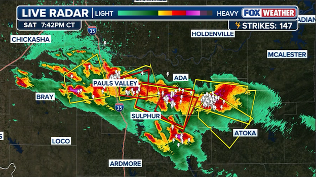
The FOX Forecast Center is currently monitoring a highly volatile situation across North Texas and Southern Oklahoma, where a cluster of powerful supercells is tracking through a "high" threat zone.
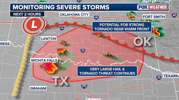
The FOX Forecast Center says the severe weather threat continues across Oklahoma and North Texas.
A primary area of concern is along a warm front stretching east of Lawton, where the potential for strong tornadoes is significantly higher as storms interact with the localized wind shift.
Meanwhile, a "triple threat" of very large hail, destructive winds, and tornadoes continues to hammer areas near Wichita Falls and across the Red River into Oklahoma.
If you are within the red-shaded area on the map, you should be prepared to take immediate shelter as these storms are expected to maintain their intensity over the next several hours.
FOX Weather Meteorologist Haley Meier is live on the ground near Ada, Oklahoma, tracking this evening's first tornado-warned storm from inside the FOX Weather BEAST.
Positioned southwest of the city, Haley is providing critical real-time updates as the storm's structure evolves.
FOX Weather BEAST camera showing darkening skies as severe storms develop in Oklahoma.
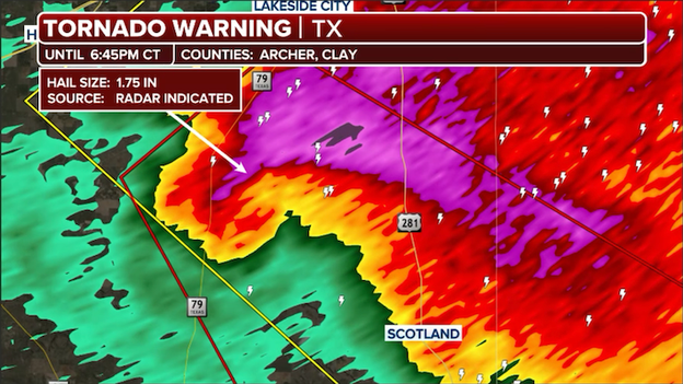
Radar showing the tornado-warned storm near Scotland, Texas.
The FOX Forecast Center is closely monitoring a dangerous supercell in Archer and Clay Counties, which is likely producing a tornado right now.
Radar signatures show intense, concentrated rotation just northwest of Scotland, Texas, and our team is awaiting visual confirmation from the field.
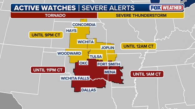
Multiple Tornado and Severe Thunderstorm Watches are in effect for multiple states in the Central U.S. right now.
As the severe weather intensifies this evening, nearly 14 million Americans are currently under a high-stakes alert, ranging from Severe Thunderstorm Watches to Tornado Warnings.
From the southern Plains through the Ozarks, communities are bracing for a dangerous night as the threat of giant hail and intense tornadoes moves into more populated corridors.
A dangerous situation is unfolding just north of Archer City, Texas, where the FOX Forecast Center has received reports of 3-inch hail—larger than the size of a baseball.
This massive hail is falling from the same rotating supercell that recently prompted a Tornado Warning for Archer and Clay Counties. Stones of this size can cause significant structural damage and are a life-safety hazard for anyone caught outdoors.
The first Tornado Warning of the evening was just for the Lone Star State in Archer and Clay Counties.
This warning follows the rapid development of a rotating storm that spun up just southeast of Wichita Falls and is now tracking toward the southeast.
The first Tornado Warning of the evening for Texas was just issued for Archer and Clay Counties.
Residents in the path of this storm, specifically those in and around Windthorst and Henrietta, should move to their pre-designated safe place immediately.
While storms in this area have already produced quarter-sized hail, this particular storm has shown a sudden increase in low-level rotation on Doppler radar, indicating that a tornado could develop or be on the ground at any moment.
Stay away from windows and keep your FOX Weather App open for real-time radar updates as this storm moves through North Texas.
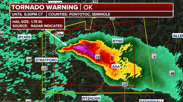
The National Weather Service has issued a Tornado Warning for Ada, Oklahoma until 6:30 p.m. CT.
The first Tornado Warning of the evening has just been issued for Ada, Oklahoma, and surrounding areas in Pontotoc County as a dangerous supercell shows signs of strong rotation.
This radar-indicated threat is moving directly toward the heart of Ada, prompting an immediate call to action for residents to seek shelter in a basement or interior room.
This storm has been identified as particularly explosive, and with exclusive FOX Weather trackers Brandon Copic and Corey Gerken currently intercepting the storm, we are receiving live reports of the "ground truth" as any potential tornado develops.
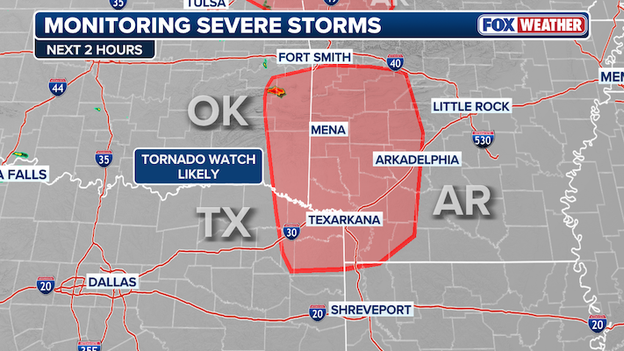
A Tornado Watch has been issued for parts of Arkansas until 1:00 a.m. CT.
The Storm Prediction Center has issued a new Tornado Watch for portions of western Arkansas, effective until 1:00 a.m. CT.
This comes as powerful supercells continue their eastward trek across the Ark-La-Tex region, maintaining a environment capable of producing dangerous weather well after sunset.
Cities included in this latest watch area include Texarkana and Arkadelphia.
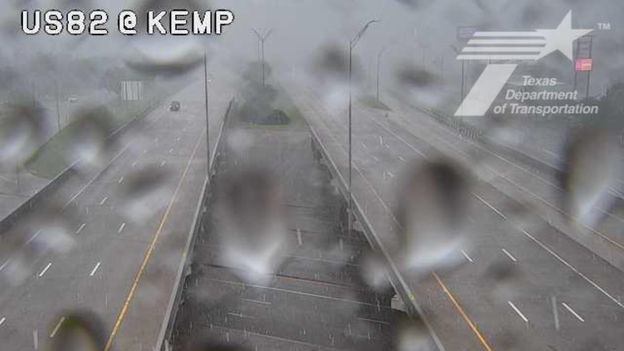
Texas Department of Transportation camera on U.S. Highway 82 at Kemp Street
Real-time video from Texas DOT traffic cameras in Wichita Falls captured intense scenes this afternoon as a severe thunderstorm hammered the area with large hail.
As the stones began to bounce off the pavement, numerous drivers were seen pulling over and parking under highway overpasses to shield their vehicles from potential damage.
While seeking shelter from hail is understandable, the FOX Forecast Center reminds drivers that parking under bridges can be extremely dangerous as it creates traffic hazards and offers no protection from the high winds of a passing tornado.
Severe thunderstorms are making their presence felt across central Kansas this evening, with the FOX Forecast Center receiving multiple reports of large hail over the past few hours.
In Rush Center and Zook, residents reported hail up to 1 inch in diameter, roughly the size of a quarter.
The intensity increased further south in Frizell, where 1.50-inch hail—the size of a ping pong ball—was confirmed.
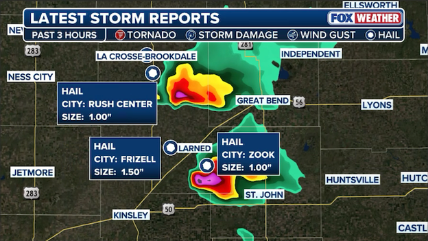
Two dangerous thunderstorms are hammering Kansas with large hail at this hour.
These reports come from storms tracking near Great Bend and St. John, signaling that the supercell environment is primed and active.
As these storms continue to move east and tap into richer moisture, the potential for even larger hail remains a significant concern for the region.
The FOX Forecast Center has received confirmed reports of quarter-size hail falling in Wichita Falls, Texas, as a powerful severe thunderstorm tracks through the area.
This hail is large enough to cause minor damage to vehicles and property, serving as a reminder that these storms are carrying significant energy as they move across the North Texas landscape.
The Storm Prediction Center says it will issue a Tornado Watch for parts of Arkansas and Louisiana in the next hour.
The FOX Forecast Center is tracking a dangerous eastward shift in today’s severe weather outbreak.
The Storm Prediction Center says a new Tornado Watch is will be issued within the hour for eastern Arkansas and northern Louisiana.
This new alert area sits directly in the path of powerful supercells currently crossing out of Oklahoma, which are moving into an environment primed with high humidity and intense atmospheric energy.
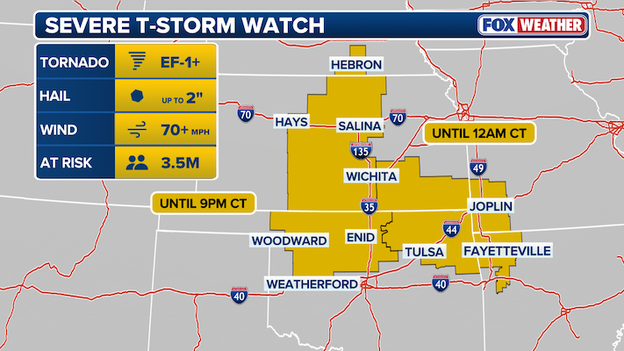
A Severe Thunderstorm Watch is in effect for parts of Arkansas, Kansas, Missouri, and Oklahoma until midnight CT.
The Storm Prediction Center has just issued a new Severe Thunderstorm Watch covering a broad region including northwest Arkansas, southeast Kansas, southwest Missouri, and northeast Oklahoma.
This watch is in effect until midnight CT, as a cluster of scattered thunderstorms is expected to develop and track east-northeast throughout the evening.
Nearly 1.5 million people in cities like Joplin, Missouri, and Fayetteville, Arkansas, are included in this latest alert area.
The main concern with this round of storms is large hail, with isolated instances of very large hail up to 2 inches in diameter—roughly the size of a hen’s egg.
Additionally, scattered wind gusts could reach 70 mph, which is strong enough to cause power outages and property damage.
While the overall tornado risk is lower in this specific watch area compared to regions further south, forecasters warn that a surface boundary near west-central Arkansas could lift north, making a tornado or two possible if storms interact with that boundary.
Exclusive FOX Weather storm trackers Brandon Copic and Corey Gerken are currently on the scene southwest of Ada, Oklahoma, positioned near the FOX Weather BEAST to monitor an explosive supercell.
A Severe Thunderstorm Warning was just issued for the Ada area as this storm rapidly intensifies, and the team is providing critical "ground truth" observations as the storm begins to show signs of organization.
Their real-time reports from the field are essential for tracking the storm's evolution and ensuring residents have the most accurate information as the threat moves into the heart of the community.
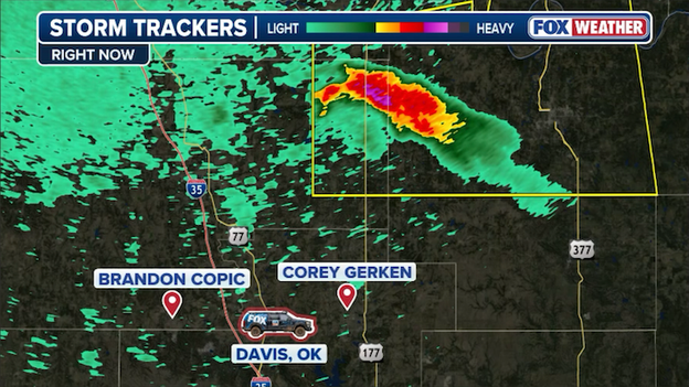
The FOX Weather BEAST and exclusive FOX Weather storm trackers are southwest of Ada, Oklahoma where a severe thunderstorm is bearing down on the city.
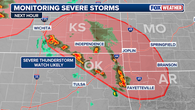
The Storm Prediction Center says it will likely issue a new Severe Thunderstorm Watch for portions of Arkansas, Kansas, Missouri, and Oklahoma in the next hour.
The Storm Prediction Center is closely watching a rapid uptick in storm activity across northeast Oklahoma and southeast Kansas, where lightning is increasing and clouds are towering upward.
These storms are currently being fueled by a surge of warm, moist air rising over a cooler boundary—a process meteorologists call isentropic ascent.
Because the atmosphere is packed with energy (instability) and plenty of wind shear to help storms tilt and spin, these cells are expected to organize into discrete supercells as they move into parts of Missouri and western Arkansas.
While it's still a bit of a question whether these storms will remain slightly elevated above the ground or root themselves right at the surface, the result for those in their path remains the same: large hail is a near-certainty.
Due to the high-energy environment, a new Severe Thunderstorm Watch is expected within the next 30 minutes to cover this growing threat.
If you are in northeast Oklahoma, central Kansas, southwest Missouri, or western Arkansas, keep a close eye on the sky and be prepared for hail that could damage vehicles and outdoor property as these storms intensify through the evening.
Fort Smith, Arkansas is now under a Tornado Watch until 11 p.m. CT.
The Storm Prediction Center has just expanded the existing Tornado Watch to include Fort Smith, Arkansas, and surrounding areas of western Arkansas.
This expansion comes as powerful supercells currently tracking through Oklahoma begin to push further east, maintaining its dangerous potential.
The watch remains in effect until 11:00 p.m. CT, as the environment continues to support the development of intense storms capable of all severe hazards.
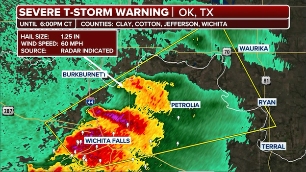
A Severe Thunderstorm Warning is in effect for Wichita Falls, Texas until 6:00 p.m. CT.
The National Weather Service has issued a Severe Thunderstorm Warning for Wichita Falls and surrounding areas until 6:00 p.m. CT as a powerful storm cell moves through the area.
This particular storm is capable of producing damaging wind gusts up to 60 mph and 1.25" hail, posing a risk to vehicles, trees, and outdoor property.
If you are in Wichita Falls, you should move indoors immediately and stay away from windows until the storm passes.
While the primary threats are wind and hail, remember that all severe thunderstorms in this environment carry the potential for rapid intensification.
Stay tuned to FOX Weather for the latest radar updates and local reports as this storm tracks through North Texas.
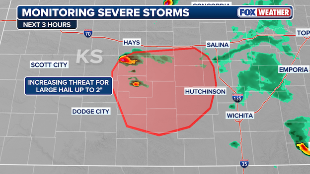
FOX Weather meteorologists are closely monitoring two supercell thunderstorms hammering Kansas with huge hail at this hour.
The FOX Forecast Center is tracking a pair of intensifying supercell thunderstorms just west of Great Bend, Kansas, that are rapidly gaining strength as they move into a more humid and unstable environment.
Satellite and radar imagery show these storms are beginning to rotate and could potentially split, a common behavior in high-energy setups that often leads to severe weather.
With the storms tapping into richer moisture and strong wind shear, the hail threat is trending upward; while reports of 1.5-inch hail have already come in, residents in the path of these cells should now prepare for hail as large as 2 inches in diameter—roughly the size of an egg or a lime—along with localized severe wind gusts.
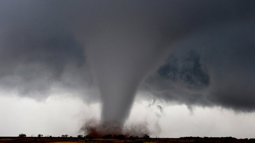
Supercells are the most dangerous type of thunderstorms and can often produce huge hail, damaging winds, and tornadoes.
Forecasting severe weather is a high-stakes puzzle where the pieces are constantly moving. To predict an outbreak like the one targeting the Central U.S., meteorologists look for a specific "recipe" of four key ingredients: moisture, instability, lift, and wind shear.
Moisture provides the fuel, instability allows air to rise rapidly, and lift (provided by fronts or drylines) acts as the spark to start the fire.
Perhaps most critically for tornadoes, wind shear—the change in wind speed and direction with height—allows storms to tilt and rotate, turning a standard rain shower into a dangerous supercell.
Even a slight shift in one of these variables can mean the difference between a sunny afternoon and a catastrophic tornado.
Fortunately, the accuracy of these forecasts has undergone a revolution over the last few decades. In the mid-20th century, "Tornado Warnings" were often issued only after a funnel was physically spotted.
Today, thanks to the development of Dual-Pol Doppler Radar, high-resolution satellite imagery like the GOES-R series, and advanced computer modeling, forecasters can identify rotation deep within a cloud before a tornado even touches the ground.
These technological leaps, combined with a dense network of ground sensors and storm spotters, have dramatically increased lead time—the precious minutes between a warning and a storm's arrival—saving countless lives by giving people more time to reach safety.
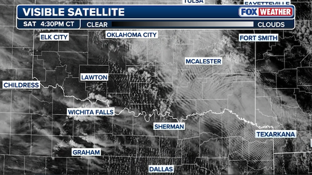
Visible satellite image from GOES-EAST showing clouds bubbling up over the Plains this afternoon.
Meteorologists in the FOX Forecast Center are currently glued to high-resolution visible satellite imagery, watching for the first signs of agitated cumulus clouds across Oklahoma and North Texas.
These bubbling clouds, often called towering cumulus, are the visual signal that the atmospheric "cap" is finally breaking, allowing warm, moist air to rocket upward.
The severe weather threat is beginning to manifest on the ground as the first round of storms moves through the Central Plains this afternoon.
In Kansas, the FOX Forecast Center has received initial reports of 1-inch hail—roughly the size of a quarter—falling from developing storms.
Reports of severe weather are starting to come into the National Weather Service from trained weather spotters and weather observation sensors in the Plains states.
Meanwhile, farther north in Nebraska, 50+ mph wind gusts and hail up to three-quarters of an inch in diameter have been reported.
While these early reports are on the lower end of today's potential, they serve as a precursor to the much more intense supercell development farther south expected later this evening.
The city of Enid is beginning the long road to recovery after a violent EF-4 tornado—the strongest recorded in the U.S. so far this year—carved a nearly 10-mile path of destruction Thursday evening.
With peak winds estimated at 170–175 mph, the twister leveled homes in the Gray Ridge neighborhood, damaged Vance Air Force Base, and left commercial buildings as piles of twisted metal.
Despite the catastrophic structural damage, officials are calling it a miracle that only 10 injuries and zero fatalities were reported, a testament to the life-saving lead time provided by National Weather Service warnings and the preparedness of the Garfield County community.
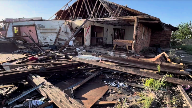
A damaged home following a tornado in Enid, Oklahoma. (Jarrod Maloney/FOX Weather)
However, there is little time for residents to catch their breath. As cleanup crews and volunteers work to clear debris and restore power, the FOX Forecast Center warns that the region remains in the threat zone for another round of severe thunderstorms today.
The sight of neighbors helping neighbors pick through the ruins of their homes has become a poignant backdrop to the new watches and warnings currently in effect.
Residents are urged to keep their weather radios on and stay vigilant, as the same atmospheric conditions that produced Thursday’s "monster" storm remain active across the Plains.
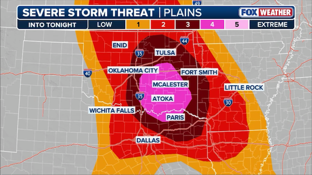
The FOX Weather Threat Zone is our proprietary mapping tool designed to clearly highlight the regions facing the greatest risk for life-threatening weather, categorizing danger into three tiers: Elevated, High, and Extreme.
Today, a massive "Elevated" zone stretches from Kansas through North Texas and into Louisiana, but the focus is on a significant "High" threat area centered over southeast Oklahoma and the Red River Valley.
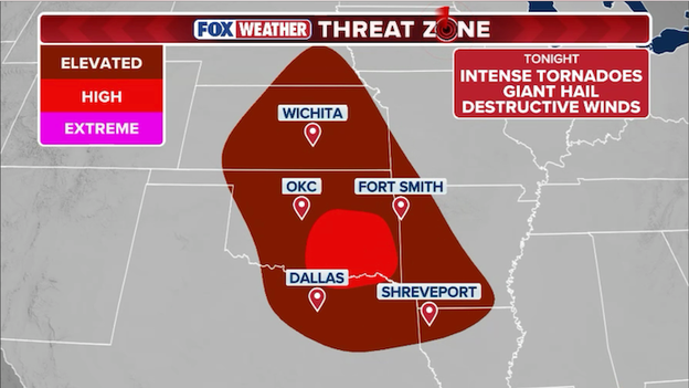
Map showing the exclusive FOX Weather Threat Zone for Saturday, showing who is at risk of dangerous severe weather.
Residents in cities like Wichita, Oklahoma City, Dallas, Fort Worth, and Shreveport are all within the danger zone and should prepare for a triple threat of intense tornadoes, giant hail, and destructive winds as storms peak tonight.
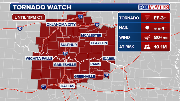
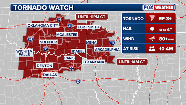
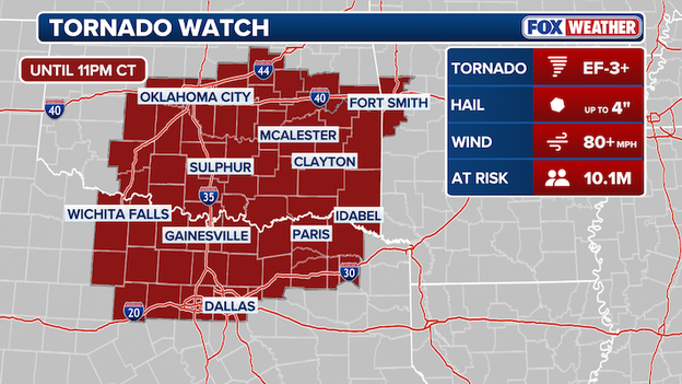
The Storm Prediction Center has issued a Tornado Watch for parts of Oklahoma and Texas until 11 p.m. CT.
The Storm Prediction Center (SPC) has officially issued a Tornado Watch for a large portion of the Southern Plains, effective until 11:00 p.m. CT.
The watch area includes central and eastern Oklahoma and north-central Texas, encompassing major metropolitan areas such as Oklahoma City and the Dallas-Fort Worth Metroplex.
This watch signifies that conditions are extremely favorable for the development of severe supercell thunderstorms.
Forecasters are warning of a significant threat that includes the potential for intense tornadoes (EF-3 or higher), giant hail up to 4 inches in diameter, and localized wind gusts exceeding 70 mph.
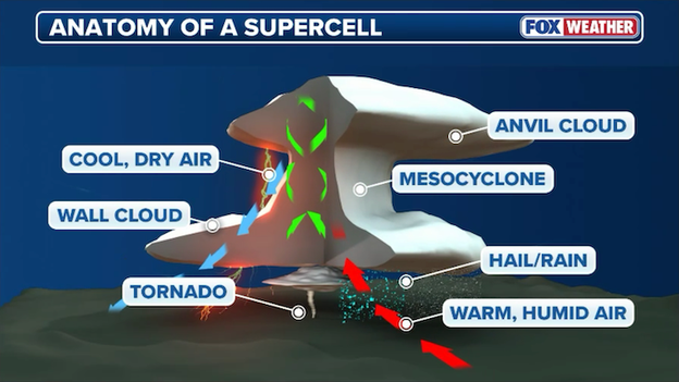
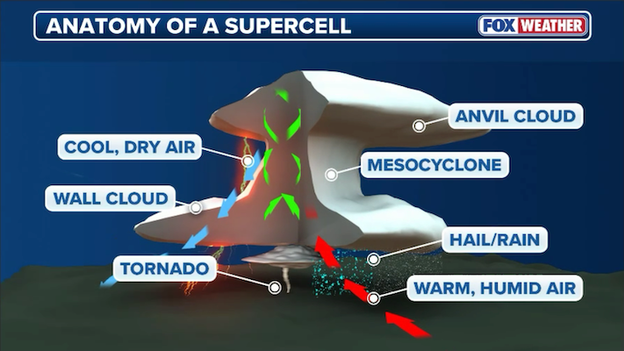
Anatomy of a supercell thunderstorm
Supercells are the most powerful and organized type of thunderstorm, characterized by a deep, persistently rotating updraft called a mesocyclone.
Unlike standard thunderstorms that rise and collapse quickly, a supercell’s internal structure allows it to tilt and separate its updraft from its downdraft.
This unique engine enables the storm to sustain itself for several hours and travel hundreds of miles, often acting as a lone parent storm that dominates the local environment.
What makes supercells so dangerous is their ability to produce all forms of severe weather simultaneously.
Because of their intense rotation and immense energy, they are the primary producers of intense tornadoes (EF-3 or higher) and giant hail that can exceed the size of grapefruits.
Additionally, they can generate extreme downburst winds and torrential rain, often leading to flash flooding.
Their longevity and intensity mean they can impact large populated areas with very little warning, making them the most significant threat to life and property during a severe weather outbreak.

FOX Weather Haley Meier inside the FOX Weather BEAST as storms develop across Oklahoma this afternoon.
FOX Weather meteorologist Haley Meier is live in the field today alongside meteorologist Jarrod Maloney, navigating the FOX Weather BEAST through the heart of Oklahoma as severe storms begin to fire.
The team is positioned to provide critical "ground truth" reports and real-time visuals, ensuring viewers stay informed as dangerous supercells develop across the Plains.
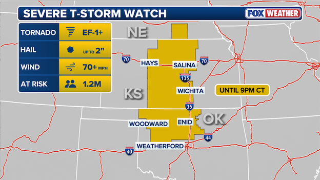
The Storm Prediction Center has issued a Severe Thunderstorm Watch for portions of Kansas and Oklahoma until 9 p.m. CT.
A Severe Thunderstorm Watch has been issued for central Kansas and northern Oklahoma until 9 p.m. CT, placing approximately 1.2 million Americans on alert.
This dangerous system is capable of producing 70+ mph wind gusts and large hail up to 2 inches in diameter, with a few tornadoes also possible as storms intensify this evening.
Residents in the watch area should stay weather-aware and be prepared to seek shelter immediately if warnings are issued for their community.
The Storm Prediction Center says it will issue a Tornado Watch for parts of Oklahoma and Texas in the next hour.
The atmosphere is priming the pump across the Southern Plains this afternoon, and the Storm Prediction Center says it will issue a Tornado Watch by 4:00 p.m. CT.
If you are in cities like Oklahoma City, Tulsa, or the Dallas-Fort Worth Metroplex, now is the time to finalize your safety plans.
Think of the atmosphere right now like a powder keg. Three different weather features—a cold front, a warm front, and a dryline (a boundary separating moist and dry air)—are all colliding over the region.
As the sun heats the ground this afternoon, the air is becoming extremely buoyant. In simple terms, there is a massive amount of fuel (warm, humid air) ready to rush upward to create massive thunderstorms.
Forecasters are concerned that any individual storm that develops this afternoon will quickly turn into a supercell—a rotating thunderstorm capable of producing the most dangerous weather.
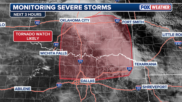
The FOX Forecast Center is closely monitoring a dangerous weather setup today as Oklahoma and Texas once again find themselves in the crosshairs of a significant severe weather outbreak.
Over 21 million Americans are under alert as a powerful storm system prepares to ignite this afternoon, bringing the threat of strong tornadoes and monster hail to the heart of the country.
The meteorological setup
A deepening low-pressure system is tracking across the Texas Panhandle, dragging a dryline into central and western Texas. To the north, a warm front is surging through Oklahoma and the Ark-La-Tex region.
This collision of atmospheric ingredients is expected to create extreme instability.
The highest concern is focused on southeast Oklahoma, where a Level 4 out of 5 severe storm threat has been issued.
A broader Level 3 risk extends across central and eastern Oklahoma, western Arkansas, and northeast Texas, including major hubs like Oklahoma City, Tulsa, Dallas, and Fort Smith.
Primary hazards and timing
- Tornado threat: FOX Weather meteorologists warn that any storms developing near the intersection of the warm front and dryline could quickly become supercells. There is a potential for intense tornadoes (EF-3 or higher), particularly from Oklahoma City shifting into the southeast portion of the state.
- Giant hail: In addition to the tornado risk, this environment is primed for gigantic hail. Residents in southeast Oklahoma and northern Texas should prepare for stones potentially exceeding 3 inches in diameter—larger than a baseball.
Dangerous storms are expected to erupt across the Central U.S. in the hours ahead.
The threat will not end at sunset. Storm coverage is expected to expand overnight, with a transition into clusters or lines of storms that will continue to pose a risk for damaging winds and flash flooding.
As this multi-day outbreak continues, residents in the path of these storms are urged to have multiple ways to receive alerts and a firm plan for seeking shelter immediately if warnings are issued.
You’ve reached the beginning of this live coverage.