Strong tornadoes slam the Plains, Upper Midwest in multi-day severe weather outbreak
Strong tornadoes slam the Plains, Upper Midwest in multi-day severe weather outbreak
Download the AppDangerous tornado outbreak leaves damage behind as even bigger threat looms Monday
View postCoverage for this event has ended.
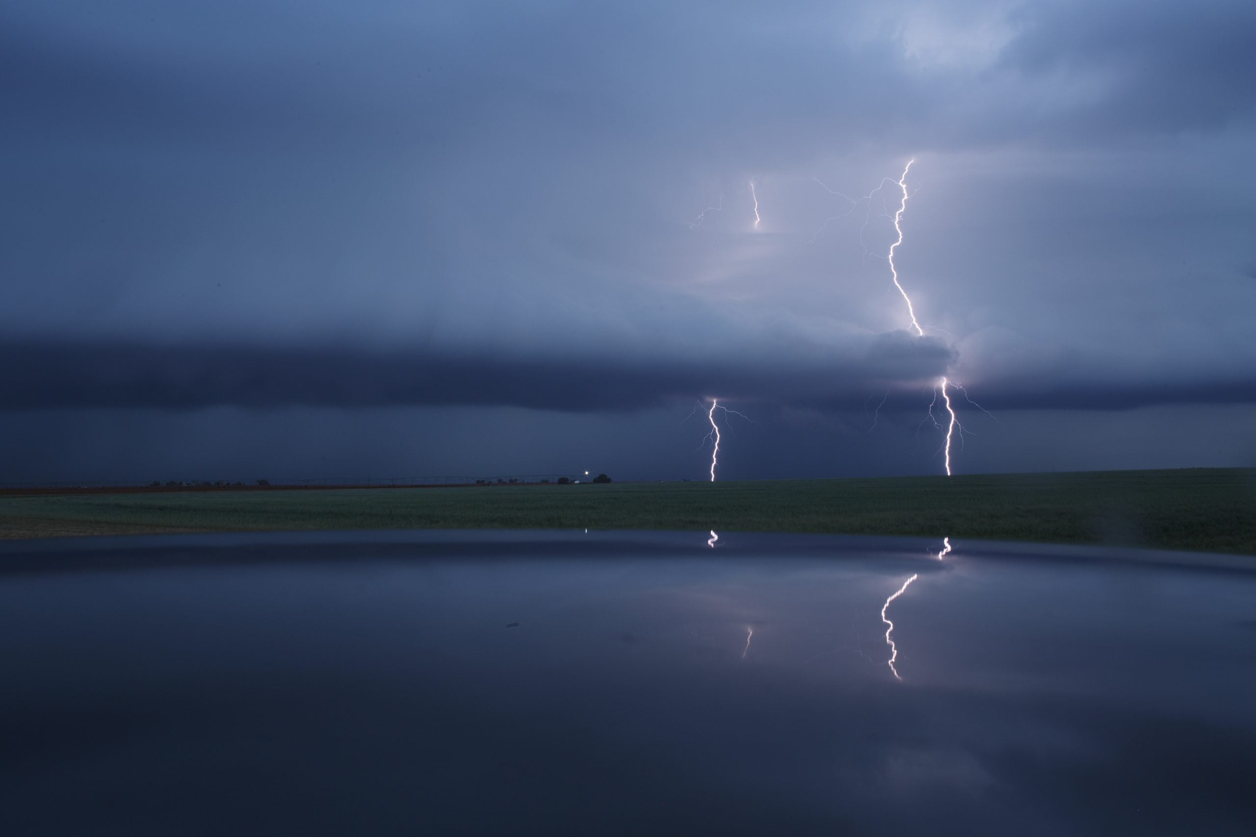
A dangerous severe weather outbreak tore across the Plains and Upper Midwest on Sunday, producing tornadoes, giant hail, destructive wind gusts and widespread damage from Nebraska and South Dakota into Iowa and Minnesota.
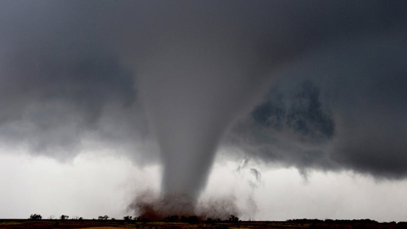
One of the most dramatic moments of the night came in Nebraska, where storm trackers captured video and images of a large tornado moving across central portions of the state.
Multiple tornado warnings — including a rare Tornado Emergency near Hebron — were issued as powerful supercells tracked across the region.
Large hail up to 3.5 inches in diameter was reported in parts of Nebraska, while damaging winds knocked out power to thousands across portions of South Dakota near the Nebraska border.
Storm reports throughout the evening included damaged buildings, overturned campers, downed trees and power lines, along with numerous reports of destructive hail and wind damage.
Tornado-warned storms also pushed into the Omaha metro area and western Iowa as the severe threat continued eastward overnight.
Dangerous storms are expected to fire up again on Monday, producing intense tornadoes, huge hail, and destructive winds.
Unfortunately, forecasters warn Monday could bring an even more dangerous setup across the central Plains. The Storm Prediction Center has already issued a rare Level 4 out of 5 risk for parts of Kansas and Nebraska, where conditions may support strong, long-track tornadoes, giant hail and widespread damaging winds.
FOX Weather will continue tracking the severe weather threat around the clock as millions remain at risk again Monday.
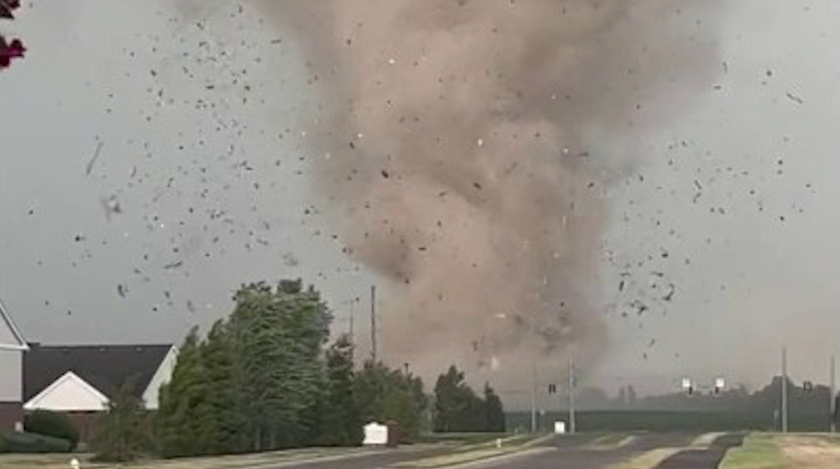
A tornado was captured crossing in front of a traffic camera along Interstate 29 near Salix, Iowa, as severe storms continue sweeping across the Plains and Upper Midwest tonight.
The dramatic video showed the tornado moving near the interstate under a tornado-warned storm as dangerous weather intensified across western Iowa.
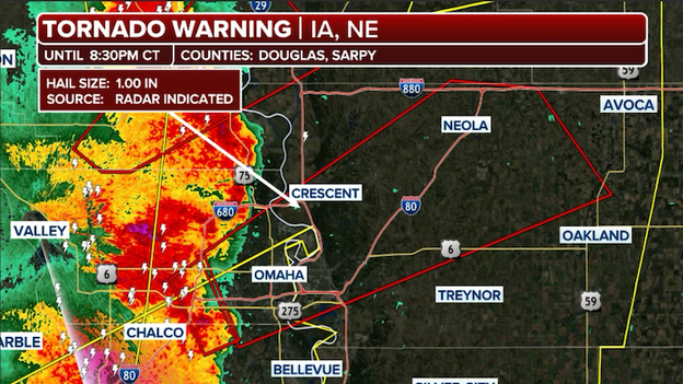
Radar showing severe thunderstorms approaching Omaha, Nebraska and a Tornado Warning extending into Iowa.
A Tornado Warning has been issued for parts of the Omaha metro area as a dangerous severe thunderstorm capable of producing a tornado moves northeast at 55 mph tonight.
The National Weather Service says the storm was located over La Vista near Ralston around 8:14 p.m. CT and has a history of producing tornadoes earlier near the Platte River northeast of Ashland.
The warning includes southeastern Omaha, Bellevue, Council Bluffs, Carter Lake and surrounding communities through 9 p.m. CT.
Forecasters warn the storm could produce a tornado along with quarter-size hail and damaging winds.
People in the warning area are urged to take shelter immediately in a sturdy building on the lowest floor away from windows as the storm moves through the Omaha metro.
Tornado Watches are in effect across multiple states as a multi-day severe weather outbreak unfolds tonight.
The Tornado Watch has now been expanded farther east to include Des Moines and portions of central Iowa until 3 a.m. CT as dangerous storms continue racing across the Plains and Midwest tonight.
Forecasters warn thunderstorms moving into Iowa could produce tornadoes, damaging winds and large hail overnight as the severe weather outbreak shifts eastward.
Residents are urged to remain weather-aware and have multiple ways to receive warnings overnight, especially while sleeping.
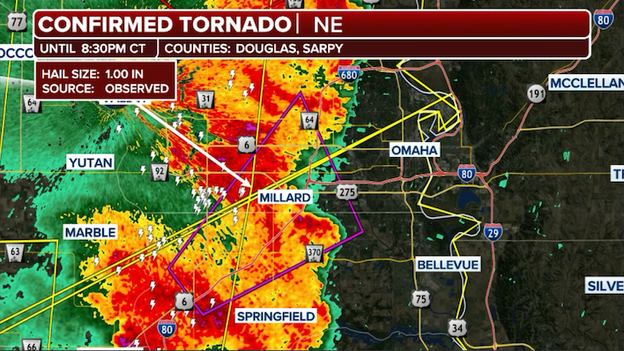
A Tornado Warning is in effect for portions of the Omaha suburbs after a tornado was spotted near Gretna, Nebraska.
A Tornado Warning is in effect for parts of the western Omaha metro area after a confirmed tornado was spotted near Gretna moving northeast at 30 mph.
The National Weather Service says the tornado was confirmed near the Platte River northeast of Ashland and could impact communities including southwest Omaha, Millard, La Vista, Chalco and nearby recreational areas this evening.
Forecasters warn the storm is capable of producing damaging winds, quarter-size hail and dangerous flying debris.
Severe thunderstorms have unleashed massive hail across parts of Nebraska today as dangerous supercells continue sweeping through the Plains.
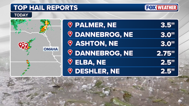
Top hail reports from across the Plains and Upper Midwest so far today.
The largest hail report so far came from Palmer, Nebraska, where hail measuring 3.5 inches in diameter was reported — roughly the size of a softball. Other communities, including Dannebrog and Ashton, reported hailstones up to 3 inches wide, capable of causing significant damage to vehicles, roofs and windows.
The giant hail is being produced by intense rotating supercells developing in an extremely unstable atmosphere across the region.
Forecasters are warning that the severe weather threat across the Plains tonight won’t just include tornadoes and damaging winds — some areas could also face dangerous flash flooding.
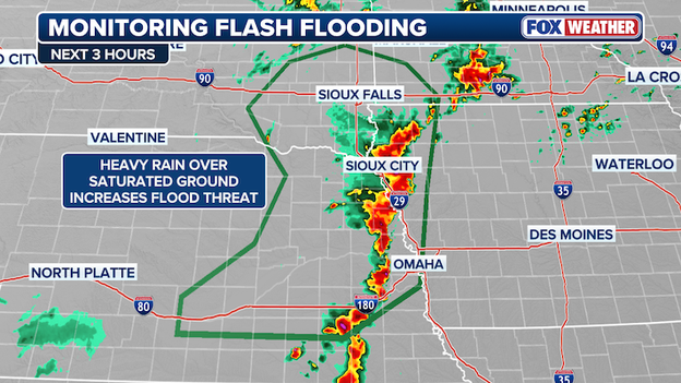
The FOX Forecast Center is closely monitoring the threat for flash flooding across portions of the Upper Midwest and Plains tonight as storms drop intense rain over the same areas.
Meteorologists at the Weather Prediction Center say thunderstorms are expected to repeatedly move over the same locations across parts of Nebraska, Kansas, Iowa and Missouri through the overnight hours. This setup, often called “training storms,” can quickly overwhelm roads, creeks and drainage systems when heavy rain falls repeatedly in a short amount of time.
Some storms could produce rain rates of 1 to 2 inches per hour, with isolated areas potentially seeing 2 to 4 inches of rain overnight. The flooding threat is especially concerning in parts of southeastern Nebraska and near the Iowa-Missouri border, where heavy rain has already fallen recently and the ground is becoming saturated.
FOX Weather meteorologists say the atmosphere remains loaded with warm, humid air and strong winds feeding into the storms, allowing thunderstorms to continue producing torrential rain well after sunset. Areas across central Kansas may also see localized flooding if storms repeatedly track over the same communities tonight.

Howard Bluestein, renowned tornado researcher and author of “Tornado Alley: Monster Storms of the Great Plains,” joined FOX Weather to discuss both his groundbreaking career studying severe storms and the dangerous weather threat unfolding across the Plains tonight.
FOX Weather Exclusive Storm Tracker Corey Gerken is being pounded by hail near Ohiowa, Nebraska, as dangerous supercells continue racing across the Plains tonight.
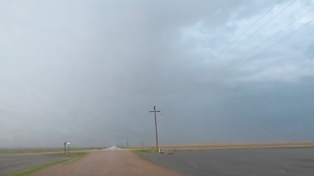
FOX Weather exclusive storm tracker Corey Gerken encountered hail while driving through Nebraska on Sunday evening.
Video from the field showed intense hail crashing down around Gerken’s vehicle while he tracked the severe storm across southeastern Nebraska. The storm is part of a broader severe weather outbreak capable of producing tornadoes, damaging winds and large hail across the region.
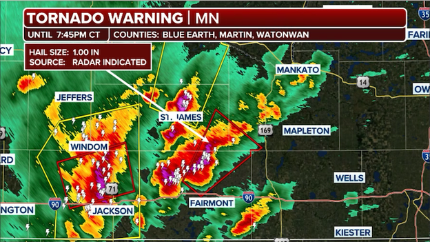
Radar image showing severe thunderstorms slamming southern Minnesota right now.
A tornado was briefly spotted north of Fairmont, Minnesota, this evening as severe thunderstorms continue moving across parts of the Upper Midwest.
The tornado was associated with a tornado-warned storm tracking through southern Minnesota amid an active severe weather outbreak across the region. Forecasters warn additional storms capable of producing damaging winds, large hail and isolated tornadoes remain possible through tonight.
Even as dangerous storms continue tonight across the Plains, meteorologists are increasingly concerned that Monday’s severe weather setup could become even more volatile.
The FOX Forecast Center says all the major atmospheric ingredients needed for significant severe weather are expected to come together across parts of Kansas, Nebraska, Iowa and Missouri.
Extremely warm, humid air surging northward will provide abundant fuel for thunderstorms, while powerful winds higher in the atmosphere will create the wind shear needed for storms to rotate and produce tornadoes.
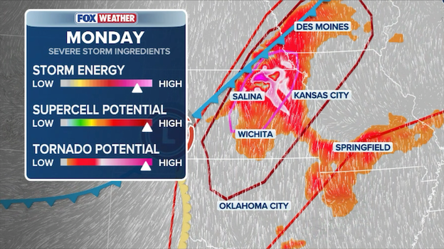
FOX Weather meteorologists say all the ingredients are coming together for a significant severe weather outbreak on Monday.
Another major concern is the strength of the upper-level storm system moving out of the Southwest. As daytime heating intensifies Monday afternoon, storms are expected to erupt rapidly along a cold front and dryline, with conditions favorable for intense supercells capable of producing strong, long-track tornadoes and giant hail.
Meteorologists also warn that storms may eventually organize into a large line during the evening and overnight hours, increasing the threat for widespread damaging winds across the central Plains.
Millions of people across Nebraska remain under threat from dangerous tornado-warned storms this evening as severe weather continues sweeping across the Plains.
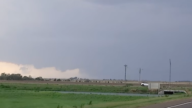
Storm trackers in Howard County, Nebraska, reported a large tornado moving across the region as powerful supercells intensified.
Multiple tornado warnings remain in effect across the state as forecasters warn conditions continue to favor strong tornadoes, large hail and damaging winds through tonight.
FOX Weather Exclusive Storm Tracker Brandon Copic is tracking the dangerous tornado near Hebron, Nebraska, as the storm moves through southeastern portions of the state tonight.
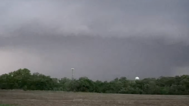
FOX Weather exclusive storm tracker Brandon Copic driving through Hebron, Nebraska during a Tornado Emergency on Sunday evening.
A Tornado Emergency is the most serious type of tornado alert issued by the National Weather Service. It is only used in rare and extremely dangerous situations when a large, destructive tornado is confirmed and threatening populated areas.
Unlike a standard Tornado Warning, a Tornado Emergency signals a potentially catastrophic and life-threatening event with a high risk of severe damage and fatalities.
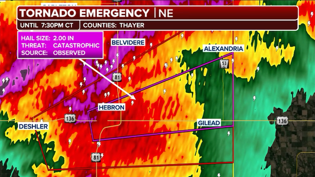
Radar showing the intense severe thunderstorm that has prompted a Tornado Emergency in parts of Nebraska this evening.
A Tornado Emergency has been issued for Hebron, Nebraska, as a dangerous and potentially life-threatening tornado moves through the area tonight.
A Tornado Emergency is the highest level of tornado alert issued by the National Weather Service and is reserved for catastrophic situations involving confirmed large and destructive tornadoes moving into populated areas.
Residents in Hebron are being urged to take cover immediately in a sturdy building, move to the lowest floor and stay away from windows. Flying debris and severe structural damage are possible as the storm moves through southeastern Nebraska.
FOX Weather Meteorologist Jane Minar is tracking the dangerous severe weather threat unfolding tonight across the Plains and Upper Midwest as multiple tornado-warned storms continue racing across the region.
The FOX Forecast Center warns the strongest storms are capable of producing tornadoes, large hail and destructive wind gusts as volatile atmospheric conditions remain in place through the evening.
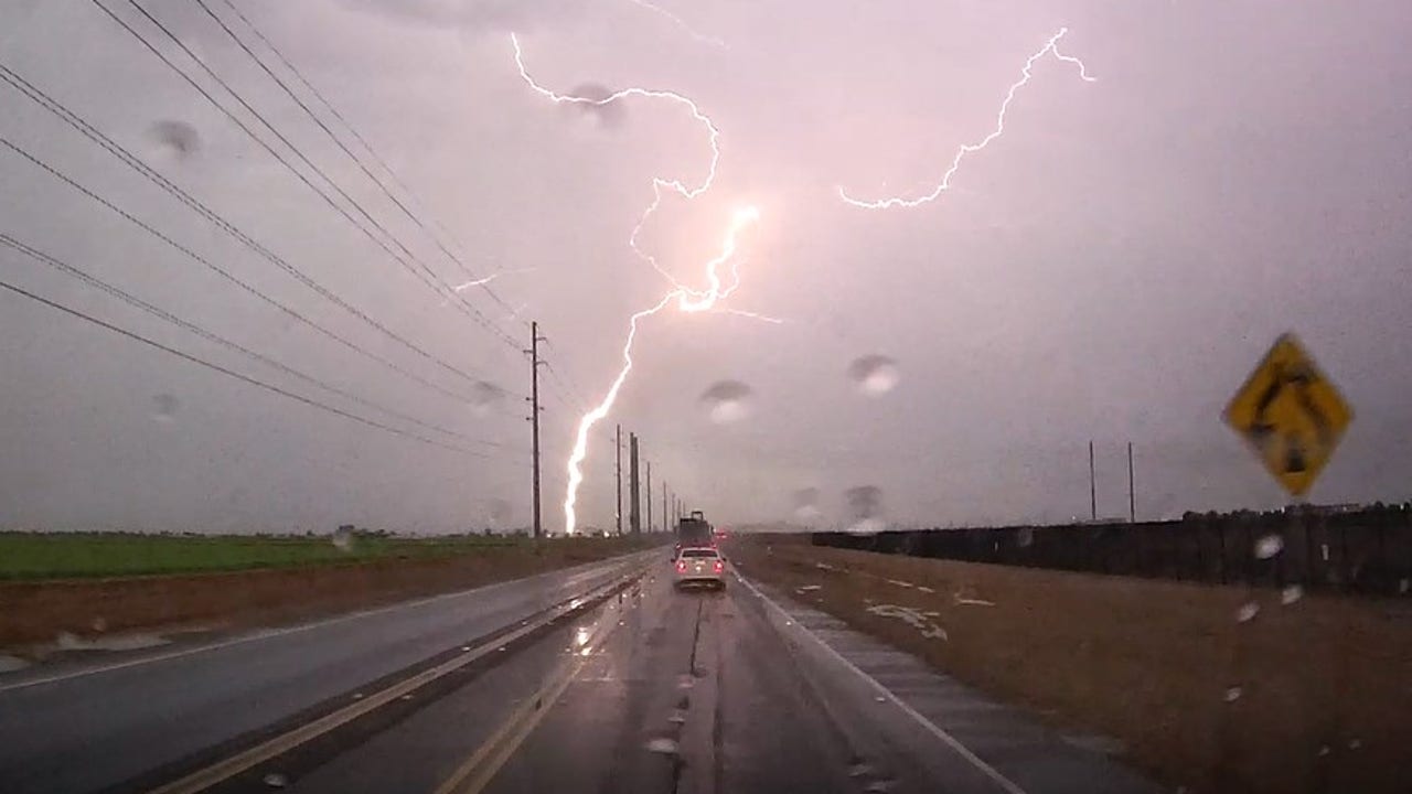
Dangerous severe thunderstorms are clobbering parts of the Plains and Midwest this evening, already producing large hail, damaging wind gusts and a few tornadoes as storms intensify across the region.
Numerous severe thunderstorm and tornado warnings have been issued from Nebraska and Kansas into South Dakota and Iowa as powerful supercells track eastward.
The FOX Forecast Center says there have been numerous reports of tornadoes, damaging winds, and large hail across the Plains states and Upper Midwest so far this evening.
Some storms have produced destructive winds strong enough to damage buildings and knock out power, while spotters have also confirmed tornadoes in portions of Nebraska.
The FOX Forecast Center warns the severe weather threat will continue through tonight as storms organize and push farther east across the central U.S.
As dangerous storms and tornadoes threaten the Plains, safety experts are reminding residents that highway overpasses are not safe shelters during a tornado.
While they may seem protective, winds can actually become stronger as they funnel through the narrow space beneath an overpass, creating a dangerous wind tunnel effect.
Meteorologists and emergency officials say the safest place during a tornado is a sturdy building on the lowest floor, ideally in an interior room away from windows.
People caught driving should never try to outrun a tornado in heavy traffic and should avoid stopping under overpasses.
Severe thunderstorms are now rapidly erupting across southern Nebraska and central Kansas as the atmosphere becomes increasingly volatile across the Plains this evening.
Radar shows multiple supercells developing along a cold front and dryline, with storms capable of producing large hail, damaging wind gusts and tornadoes. Forecasters warn some of these storms could quickly intensify as they track eastward through the evening hours.
Radar shows severe thunderstorms erupting now across Nebraska and Kansas.
The environment across the region remains highly favorable for dangerous severe weather, including the potential for strong tornadoes and destructive hail.
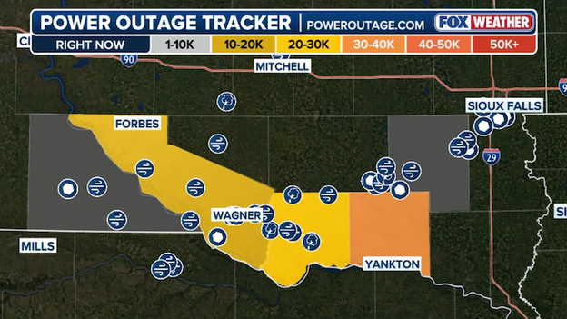
Power Outage Tracker showing the latest outages along the South Dakota-Nebraska border. (PowerOutage.com)
Thousands of customers are without power across parts of southeastern South Dakota after a dangerous line of severe thunderstorms blasted through the region this afternoon.
The most significant outages are being reported in Yankton and Bon Homme counties along the Nebraska border, where powerful wind gusts from the storms likely damaged power lines and electrical equipment.
The storms brought destructive winds, heavy rain and intense lightning as they swept eastward across the region. Utility crews are expected to continue assessing damage and working to restore power through the evening.
FOX Weather Exclusive Storm Tracker Corey Gerken is positioned just east of a dangerous tornado-warned supercell moving across central Nebraska this evening.
The storm has already prompted reports of tornado damage, though officials have not yet confirmed exactly where the damage occurred or how many homes or businesses may have been impacted.
FOX Weather exclusive storm tracker Corey Gerken is closely tracking the tornado-warned storm in Nebraska right now.
Video from the area shows a massive rotating storm structure stretching across the Nebraska sky as the severe weather threat continues.
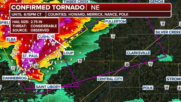
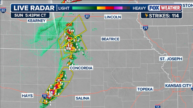
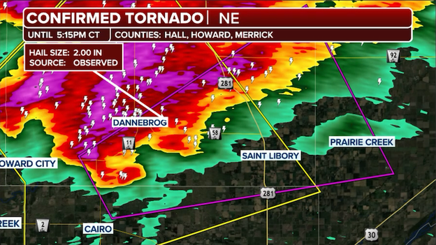
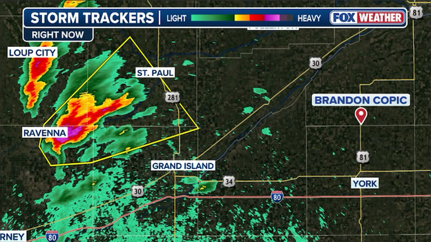
A Tornado Warning has been issued for parts of central Nebraska after spotters confirmed a large and extremely dangerous tornado was spotted near St. Libory.
The National Weather Service has issued a Particularly Dangerous Situation (PDS) Tornado Warning for parts of central Nebraska after a large and extremely dangerous tornado was confirmed near St. Libory, about 15 miles north of Grand Island.
The tornado was moving northeast at 45 mph and threatens portions of Nance, Merrick, Polk and Howard counties through 6:15 p.m. CT.
Meteorologists warned this is a life-threatening situation capable of causing catastrophic damage, including the destruction of homes, vehicles and mobile homes.
FOX Weather exclusive storm tracker Corey Gerken is approaching the tornado-warned storm in Nebraska right now.
FOX Weather Exclusive Storm Tracker Corey Gerken is closing in on a tornado-warned supercell in central Nebraska as dangerous severe weather continues to intensify this evening.
The storm has already prompted a Tornado Warning after spotters confirmed a tornado near Dannebrog. Gerken is positioning safely near the storm to monitor its development as it moves northeast across the state.
A Tornado Warning is in effect for portions of Nebraska with trained weather spotters confirming a tornado near Dannebrog.
A Tornado Warning remains in effect until 5:15 p.m. CT for parts of central Nebraska after storm spotters confirmed a tornado near the Hall and Howard County line just south of Dannebrog.
The tornado was located about 14 miles northwest of Grand Island and moving northeast at 35 mph. The storm is also capable of producing hail up to 2 inches in diameter.
Forecasters warn flying debris will be dangerous to anyone caught outside, while mobile homes could be heavily damaged or destroyed. Damage to roofs, vehicles and trees is also possible as the storm moves through rural portions of Merrick, Howard and Hall counties.
Dangerous severe thunderstorms are beginning to erupt across parts of the Plains and Upper Midwest this evening, bringing the threat of damaging wind gusts, large hail and possible tornadoes.
FOX Weather spoke with National Weather Service Hastings Warning Coordination Meteorologist Michael Moritz, who warned residents to stay weather-aware through tonight as storms intensify across the region.
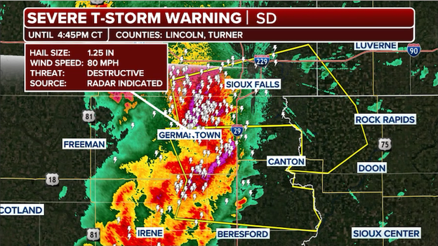
A Severe Thunderstorm Warning is in effect for Sioux Falls, South Dakota and surrounding communities as a line of dangerous storms roars east.
Dangerous severe thunderstorms are roaring toward the Sioux Falls, South Dakota, area this evening, prompting forecasters to issue a Severe Thunderstorm Warning with a rare “destructive” tag just south of the city.
The warning includes parts of Lincoln and Turner counties, where radar indicates the storm is capable of producing wind gusts up to 80 mph along with quarter-size hail.
Meteorologists use the “destructive” tag when storms are capable of producing widespread significant damage, similar to the impacts seen in weaker tornadoes.
Radar imagery shows an intense line of thunderstorms pushing northward toward the Sioux Falls metro area with extremely heavy rain, frequent lightning and damaging winds.
A new severe thunderstorms has erupted just west of Brandon Copic's position in Nebraska and has already produced severe hail and winds.
A new Severe Thunderstorm Warning has been issued in Nebraska for a rapidly intensifying storm located just west of FOX Weather Exclusive Storm Tracker Brandon Copic’s position this afternoon.
The warned storm over Buffalo, Hall, Howard, and Sherman Counties has already produced hail up to one inch in diameter, according to the National Weather Service. Radar indicates the storm continues to strengthen as it moves eastward across the region, producing golf ball-size hail and 60 mph winds.
FOX Weather storm trackers are closely monitoring the supercell as conditions remain favorable for additional severe weather development across Nebraska tonight.
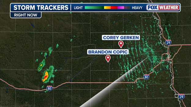
Radar image showing storms firing up across Nebraska as Storm Trackers Brandon Copic and Corey Gerken prepare to track the storms as they move east this evening.
FOX Weather Exclusive Storm Trackers Brandon Copic and Corey Gerken are prepositioned in eastern Nebraska this afternoon as severe thunderstorms begin erupting farther west across the Plains.
The storm trackers are monitoring rapidly developing supercells capable of producing large hail, damaging winds and possible tornadoes as the atmosphere becomes increasingly volatile across Nebraska and neighboring states.
Radar imagery shows storms intensifying west of their location, with FOX Weather meteorologists warning that some thunderstorms could quickly become dangerous as they move eastward through the evening.
Dangerous severe thunderstorms are causing damage across parts of South Dakota this afternoon as powerful storms continue sweeping through the region.
In Avon, trained storm spotters reported a shed had its roof blown off during intense winds associated with the storms. Farther east near Tripp, reports indicate farm outbuildings were heavily damaged and a fifth-wheel camper was overturned by powerful wind gusts.
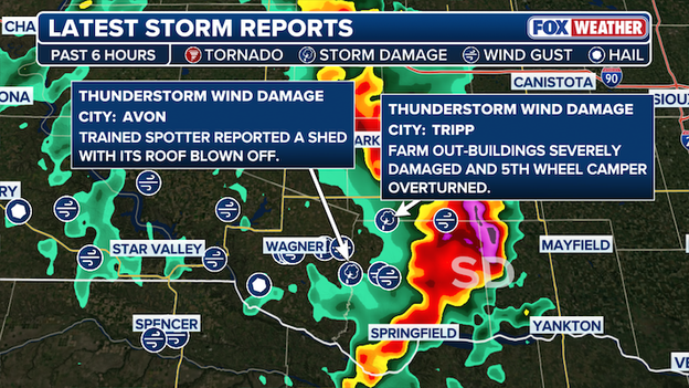
Severe storms are ripping through southern South Dakota this afternoon.
Radar imagery shows a line of severe thunderstorms stretching across southeastern South Dakota, with storms capable of producing destructive straight-line winds, large hail and isolated tornadoes.
The FOX Forecast Center warns the severe weather threat will continue through the evening as storms move eastward across the northern Plains.
Storm Trackers encountered blinding rain and relentless hail while chasing severe thunderstorms across western Kansas this weekend as dangerous weather erupted across the Plains.
The National Weather Service warned that a brief tornado or two was possible in the region as powerful storms intensified. Video from the scene showed hail pounding vehicles while intense thunderstorms moved across the area.
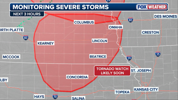
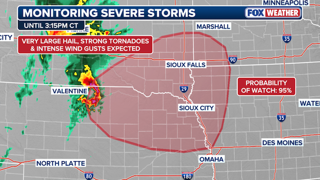
The Storm Prediction Center has issued a new Tornado Watch for portions of Nebraska, Iowa, and Kansas until 11:00 p.m. CT.
A new Tornado Watch has been issued for portions of northern Kansas, western Iowa and Nebraska through 11:00 p.m. CT as dangerous severe thunderstorms begin developing across the central Plains.
Forecasters warn that conditions are highly favorable for intense supercell thunderstorms capable of producing intense tornadoes, giant hail and destructive wind gusts through this evening.
Warm, humid air combined with strengthening winds higher in the atmosphere is creating an environment supportive of rotating storms that could rapidly intensify over the next several hours.
FOX Weather meteorologists say some storms may produce very large hail and tornadoes before eventually evolving into a larger line of severe thunderstorms later tonight, increasing the threat for widespread damaging winds.
Forecasters at the Storm Prediction Center say a new Tornado Watch will likely be issued soon for parts of south-central and southeast Nebraska into north-central Kansas as conditions become increasingly favorable for dangerous severe thunderstorms.
The Storm Prediction Center says it will issue a Tornado Watch for portions of Nebraska and Kansas in the next hour or two.
Meteorologists say the atmosphere is rapidly becoming more unstable this afternoon as temperatures climb and humidity surges across the region. Satellite imagery shows growing cumulus clouds bubbling up ahead of a cold front and dryline — often an early sign that thunderstorms are preparing to develop.
Once storms form, forecasters expect some to quickly become rotating supercells capable of producing very large hail, damaging winds and strong tornadoes. The tornado threat is expected to increase into the evening as winds strengthen near the ground, creating an environment highly supportive of rotating storms.
Dangerous severe thunderstorms are rapidly intensifying along the South Dakota-Nebraska border this afternoon, already producing destructive wind gusts and large hail as storms track across the northern Plains.
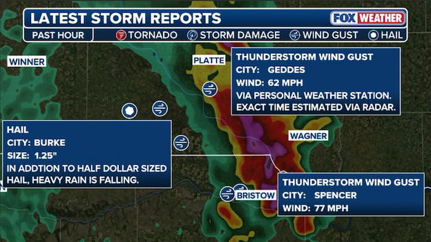
Severe thunderstorms are producing 75+ mph winds and damaging hail along the South Dakota-Nebraska border this afternoon.
FOX Weather storm reports show wind gusts reaching 77 mph near Spencer, South Dakota, with another gust of 62 mph reported near Geddes.
Large hail has also been reported near Burke, South Dakota, where quarter-size hail and torrential rainfall were occurring as storms pushed through the area.
Radar imagery shows a powerful line of thunderstorms stretching across portions of south-central South Dakota into northern Nebraska. Some of the strongest storms are capable of producing damaging straight-line winds, large hail and possibly tornadoes as atmospheric conditions continue to become more favorable for severe weather.
Forecasters warn the threat is expected to continue increasing through the late afternoon and evening hours as storms organize and move eastward across the region.
Even as dangerous severe storms unfold across the Plains this afternoon, the FOX Forecast Center is warning that Monday’s setup could become even more intense.
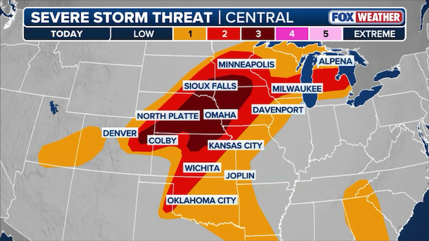
The FOX Weather Threat Zone shows a high threat for severe weather, including intense tornadoes across Kansas, western Missouri, and Iowa.
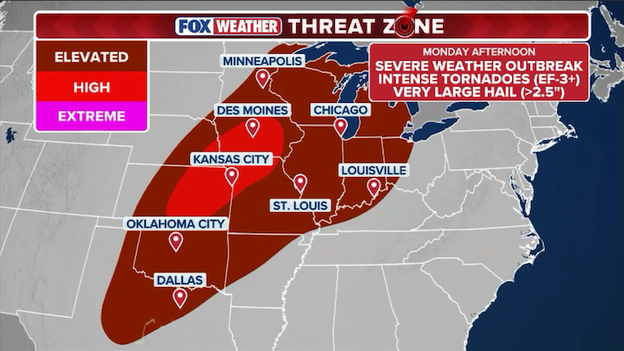
The FOX Weather Threat Zone shows a high threat for intense tornadoes, huge hail, and destructive winds across portions of the Midwest and Plains on Monday afternoon into the overnight hours.
FOX Weather meteorologists say a powerful storm system moving out of the Southwest will collide with hot, extremely humid air across the Plains, creating a volatile atmosphere primed for explosive thunderstorm development Monday afternoon and evening.
The greatest threat is expected from central Kansas into southeastern Nebraska, southwestern Iowa and northwestern Missouri. As temperatures climb into the 80s and humidity surges, the atmosphere will become increasingly unstable through the day.
Forecasters expect thunderstorms to rapidly develop by mid-to-late afternoon along a cold front and dryline. Once storms form, they could quickly become intense rotating supercells capable of producing strong, long-track tornadoes and hail as large as baseballs or even softballs.
The threat may continue well into Monday night. As storms begin clustering together during the evening, the danger could shift toward widespread damaging winds capable of knocking down trees and power lines across large areas.
Residents across the central Plains should closely monitor forecasts and prepare now for the possibility of dangerous severe weather Monday afternoon and night.
As severe weather threatens parts of the Plains, it’s important to understand the difference between a Tornado Watch and a Tornado Warning — and what each means for your safety.
A Tornado Watch means conditions are favorable for tornadoes to develop. Watches are typically issued for large areas covering multiple counties and can last for several hours. During a watch, residents should stay alert, monitor forecasts and have a plan in place in case storms intensify quickly.
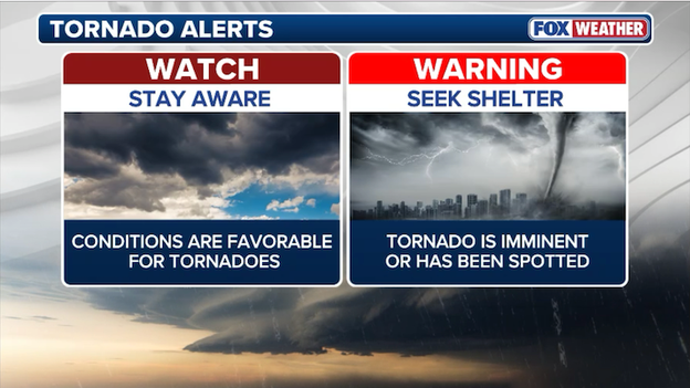
The National Weather Service issues a variety of alerts to help protect Americans from severe weather. Tornado Watches and Warnings are issued when conditions are favorable for severe weather and tornadoes to occur.
A Tornado Warning is much more urgent. Warnings are issued when a tornado has either been spotted by trained observers or indicated on weather radar. This means a tornado may be occurring or imminent in the warned area, and people should take shelter immediately.
The easiest way to remember the difference is: a watch means “be prepared,” while a warning means “take action now.”
FOX Weather meteorologists recommend having multiple ways to receive alerts, especially during overnight severe weather events when warnings may be issued while people are sleeping.
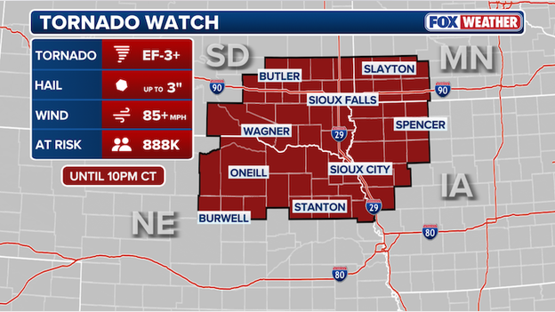
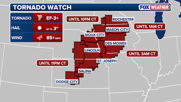
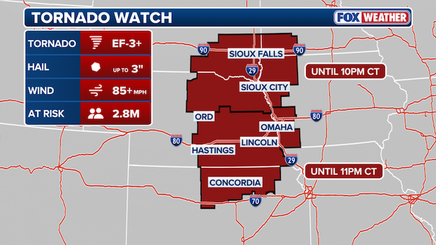
The Storm Prediction Center has issued a Tornado Watch for portions of Nebraska, Iowa, South Dakota, and Minnesota until 10:00 p.m. CT. The watch means conditions are favorable for severe weather and tornadoes to develop.
A Tornado Watch has been issued for portions of Iowa, Nebraska, South Dakota and Minnesota through 10 p.m. CT as dangerous severe thunderstorms begin developing across the northern Plains.
The FOX Forecast Center warns that conditions are becoming increasingly favorable for powerful supercell thunderstorms capable of producing strong tornadoes, giant hail and destructive wind gusts through this evening.
The watch includes cities and communities across eastern Nebraska, southeast South Dakota, northwest Iowa and southwest Minnesota, where warm, humid air and strengthening winds in the atmosphere are creating an environment supportive of rotating storms.
Meteorologists say some storms could produce hail larger than baseballs, wind gusts approaching hurricane force and tornadoes that may become strong and long-lived.
People in the watch area are urged to stay weather-aware throughout the evening and make sure they have multiple ways to receive warnings if severe storms develop rapidly.
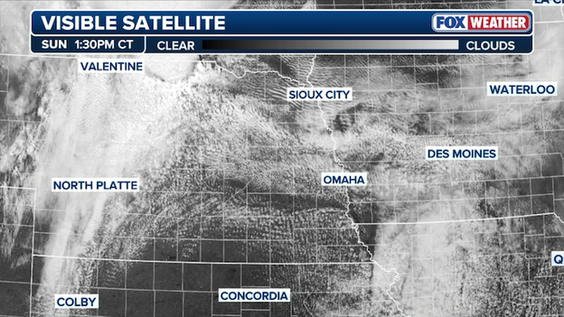
GOES-East satellite image showing cumulus clouds rapidly developing over Nebraska and Iowa as the atmosphere becomes unstable this afternoon.
GOES-East satellite imagery is beginning to show agitated cumulus clouds bubbling up across parts of Nebraska this afternoon — a sign that the atmosphere is rapidly destabilizing ahead of the expected severe weather outbreak.
FOX Weather meteorologists watch these growing cumulus fields closely because they often indicate the atmosphere is becoming unstable enough to support thunderstorm development. As temperatures continue to warm and humidity increases, conditions are becoming more favorable for supercells capable of producing tornadoes, giant hail and damaging winds later today.
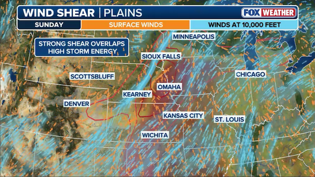
Strong wind shear will combine with unstable air across the Plains to spark severe thunderstorms that will be capable of producing tornadoes, huge hail, and damaging winds through the evening hours.
The FOX Forecast Center says the greatest threat for tornadoes and giant hail later today will develop across parts of eastern Nebraska, southeast South Dakota, northwest Iowa and nearby portions of northeast Kansas and southwest Minnesota.
That’s where the atmosphere is expected to become especially dangerous as strong wind shear overlaps with very warm, humid and unstable air. In simple terms, the air near the ground will be extremely energetic, while winds higher in the atmosphere will be changing speed and direction with height — a key ingredient for rotating thunderstorms.
Meteorologists say this setup favors the development of powerful supercell thunderstorms capable of producing strong tornadoes, destructive wind gusts and hail potentially larger than baseballs.
The severe weather threat is expected to increase rapidly during the late afternoon and continue into the evening as storms intensify across the region. Some tornadoes could become long-lived if isolated supercells remain discrete before storms eventually organize into a larger line later tonight.
Residents across the northern and central Plains are urged to closely monitor forecasts and be prepared to act quickly if watches or warnings are issued.
Forecasters at the Storm Prediction Center say a Tornado Watch will likely be issued soon for parts of the northern Plains as conditions become increasingly favorable for dangerous severe thunderstorms.
The Storm Prediction Center says it will issue a Tornado Watch for portions of South Dakota, Minnesota, Iowa, and Nebraska this afternoon.
The areas most at risk include southeast South Dakota, northeast Nebraska, northwest Iowa and southwest Minnesota, where storms are expected to rapidly intensify through the afternoon and evening hours.
Meteorologists warn that the atmosphere is becoming highly unstable as warm, humid air spreads northward beneath strengthening winds higher in the atmosphere. That combination can help thunderstorms rotate, creating powerful supercells capable of producing strong tornadoes, giant hail and destructive wind gusts.
The FOX Forecast Center says hail up to 3.5 inches in diameter, wind gusts approaching 90 mph and strong tornadoes are all possible as storms develop later today.
Storms are expected to begin as isolated supercells capable of producing tornadoes and very large hail. Later this afternoon and evening, additional storms may organize into a larger line of thunderstorms, increasing the threat for widespread damaging winds across the region.
People in the threatened areas are urged to stay weather-aware throughout the day and have multiple ways to receive warnings as dangerous conditions continue to develop.
The threat of dangerous severe weather is ramping up across the Plains on Sunday, with forecasters warning that conditions could become increasingly volatile by late afternoon and evening.
The Storm Prediction Center has placed a large portion of the Central Plains and Middle Missouri Valley under a level 3 out of 5 on the agency’s severe weather scale. Areas included in the heightened threat zone include eastern Nebraska, northeast Kansas, northwest Iowa and southeast South Dakota.
Severe thunderstorms are expected to erupt across the Plains later this afternoon-evening with strong tornadoes, huge hail, and damaging winds all possible across a dozen states.
Forecasters say the atmosphere across the region will become primed for severe thunderstorms as warm, humid air surges northward through the day. That moisture, combined with strengthening winds higher in the atmosphere, will create favorable conditions for rotating supercell thunderstorms capable of producing strong tornadoes and exceptionally large hail.
The greatest concern will develop during the late afternoon and early evening hours, when any storm that forms could rapidly intensify.
Meteorologists say the setup could support powerful supercells capable of producing hail large enough to cause significant damage, along with tornadoes that may become strong and long-lived.
As the evening progresses, the severe weather threat is expected to evolve. Individual supercells are forecast to merge into a larger line of thunderstorms as a strengthening low-level jet develops after sunset. Once storms organize into a squall line, the primary threat will shift from tornadoes to widespread damaging winds.
That line of storms is expected to push eastward through the evening and overnight hours, bringing the potential for destructive wind gusts across parts of the Plains and Midwest before gradually weakening later tonight.
Farther south, forecasters are also monitoring parts of western Oklahoma, the Texas Panhandle and Kansas near the dryline, where isolated severe thunderstorms may erupt late Sunday. While a cap of warm air aloft could limit how many storms develop, any storm that breaks through the lid could quickly become severe with massive hail and intense wind gusts.
Meanwhile, parts of Illinois, Wisconsin and Michigan could also see isolated severe storms near a warm front later Sunday if enough sunshine breaks through lingering cloud cover and helps destabilize the atmosphere.
You’ve reached the beginning of this live coverage.