LIVE: Severe Weather across Central U.S.
LIVE: Severe Weather across Central U.S.
Download the AppCoverage for this event has ended.
Initial damage reports
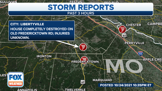
Tornado damage reports continue to come in. The tornado in Libertyville, MO knocked a home down.
Emergency managers in Madison County, MO are reporting "extensive damage" and injuries to areas along highway 72 near Black River.
In New Minden, IL a car was blown off the road. Chester, IL officials report damage the fire station.
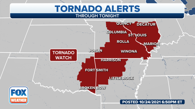
Tornado Watches
Tornado Watches continue across Arkansas until 11 PM CDT. Southeast Missouri and the southern half of Illinois are under a Tornado Watch until 1 PM CDT.
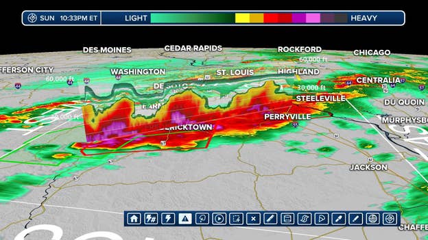
A slice of radar showing the intensity of the system in purple.
Emergency crews report major damage in St. Mary, MO after a tornado blew though. The dangerous storm is moving NE at 35 mph.
This is FOX Weather's volumetric slice looking inside the tornado that has already destroyed a home.
Tornado snapped trees and power poles. Roofs were pulled off buildings in Junction City, MO.
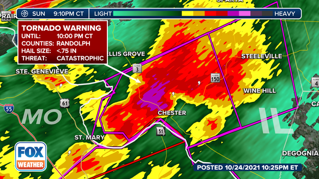
PDS Tornado Warning
A large, destructive tornado is over Chester, MO moving NE at 30 miles per hour. The tornado warning was extended until 10 PM CDT. Tornado damage is eminent in highly populated areas.
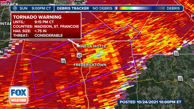
Debris Tracker
FOX Weather's Debris Tracker shows a tremendous amount of debris around the tornado near Fredericktown, MO. Tree limbs, siding, roof tiles, even patio furniture can become deadly blown by these winds. Radar is showing hail over 0.75 inches in diameter.
A tornado near Fredericktown in St. Francois County, MO is moving NE at 40 mph. Cobalt and Junction City are in the path. Please take cover.
Storm chaser reports 10 medium to small trees were uprooted along Highway 54 in Pike County, Illinois. (Via National Weather Service)
Missouri State Patrol reports that in Pettis County north of U.S. 50 there is minor damage to a few roofs, large trees and limbs down and a canoe into the window of a residence. (Report via: National Weather Service)
A recap of severe weather damage reports in northern Missouri into the National Weather Service in Kansas City so far (All times Central Daylight Time:)
TORNADOES:
* 2:12 p.m. Tornado reported in Troy, Kansas
* 3:20 p.m.: Possible tornado near Coffey, Missouri. Trees uprooted.
*3:30 p.m.: Tornado reported in Mirable, Missouri with roof damaged.
*4:47 p.m.: Tornado reported in Linneus, Missouri
* 5:20 p.m.: Tornado crossed Highway 129 near Winnegan, Missouri.
There are no reports of any significant damage or injuries yet.
HAIL:
* 4:02 p.m.: 1.50 inch hail in Breckenridge, Missouri.
A storm chaser reports a tornado crossed highway 129 near Winigan, Missouri. No reports of damage yet.
The tornado possibilities continue to push east just north of Kansas City.
Much of Missouri lies in the path of the severe march of storms which bring quarter-sized hail, 60 mph winds and possible tornadoes.
Current Time Line:
Under severe threat now: Maryville, St. Joseph, Kansas City and Nevada
Severe threat 4-5 PM CDT: Chillicothe, Sedalia, Clinton
Severe threat 5-6 PM CDT Kirksville, Moberly, Columbia, Osage Beach
The NWS confirmed a tornado 7 miles west of Kingston moving east at 35 mph. A Tornado Warning remains in effect for Daviess, Gentry, Dekalb, Clinton and Caldwell Counties until 4 PM CDT. Radar indicated a tornado near Maysville moving NE at 30 mph. Nearby areas have seen quarter-sized hail and 60 mph winds.
Pattonsburg, Jameson, Weatherby, McFall, Fairport, and Santa Rosa residents should take precautions. Avoid I-35 in the area as well.
A line of Severe Thunderstorms quickly heads through northwest Missouri. Within the severe storms, a tornado is exiting Troy, KS and headed north of Saint Joseph. Take precautions.
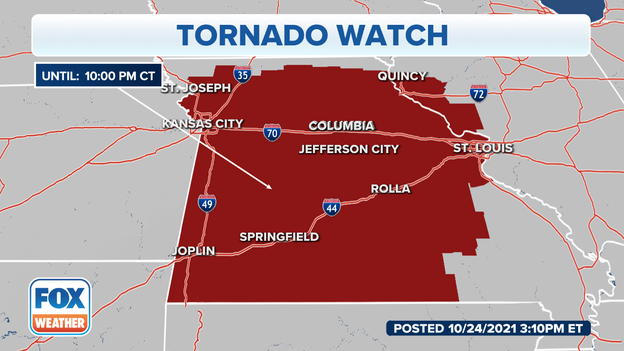
A tornado watch has been issued for parts of Illinois and Missouri until 10 PM CDT
A tornado watch has been issued for a good portion Missouri and several counties in Illinois until 10 PM CDT.
You’ve reached the beginning of this live coverage.