More then 50 winds gusts of at least 75 mph reported so far
Andrew Wulfeck
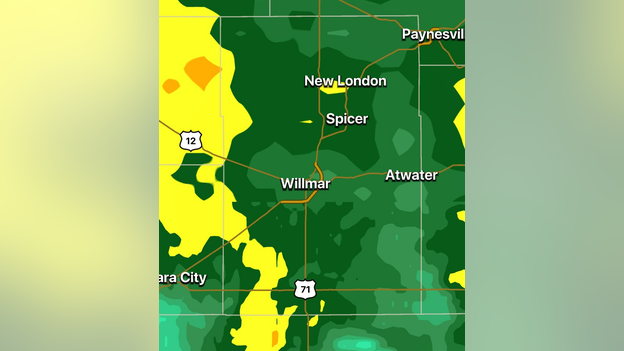
Storm death reported in Kandiyohi County, MN
FOX Weather 3D Radar
Emergency management in Kandiyohi County, MN reports one person was killed after a grain bin fell on a car Thursday evening near the rural town of Blomkest. Severe thunderstorms were around at the time of the incident.
Andrew Wulfeck
VIDEO FORECAST: Storm threat shifts eastward on Friday
Tornado-warned storm moving into northern Minnesota
A tornado-warned storm is moving towards northern Minnesota. The National Weather Service has issued a Tornado Warning for several counties as the storm moves northward.
Andrew Wulfeck
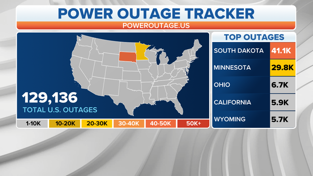
Damaging winds cause more than 70K power outages
PowerOutage.US
More than 70K outages have been reported from the Plains into the Upper Midwest because of damaging winds.
A storm continues to produce Tornado Warnings on its trek through through Minnesota.
Andrew Wulfeck
Power outages reported across Plains, Upper Midwest
Andrew Wulfeck
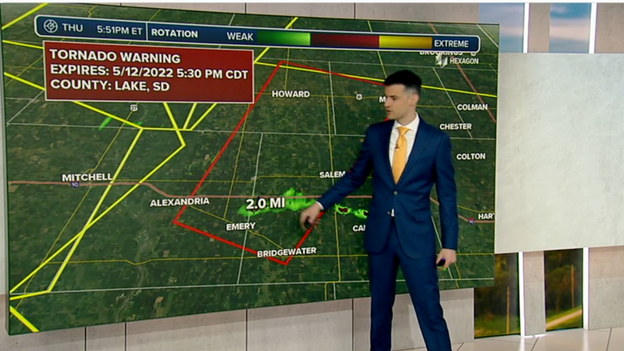
Line of storms triggers Tornado Warnings in Minnesota
Several Tornado Warnings have been issued in Minnesota which now include areas around Renville, Prinsburg and Blomkest.
Andrew Wulfeck
Tornado Warnings issued in southern Minnesota
Severe storms have now moved into southern Minnesota and have forced meteorologists to issue Tornado Warnings for several counties.
Andrew Wulfeck
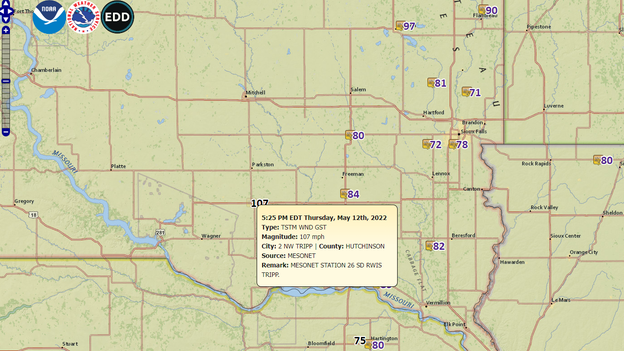
Winds over 100 mph reported in South Dakota
Wind Report
Winds around Tripp, SD were reported to be over 100 mph as the severe storms rolled in. More than 25,000 power outages were reported in the state.
Andrew Wulfeck
VIDEO: Haboob moves through South Dakota
In addition to the severe weather, damaging winds are picking up dirt and dust and reducing visibilities for areas around the South Dakota-Nebraska line.
Andrew Wulfeck
FOX Weather 3D Radar tracking several tornado-warned storms in SD
FOX Weather 3D Radar
The FOX Weather 3D Radar is tracking several tornado-warned storms through the state of South Dakota. The latest Tornado Warning was issued for areas around Watertown SD and I-29.
Andrew Wulfeck
SATELLITE IMAGE: Haboob sweeping across the Plains
The strong winds associated with the storm system moving through the Plains has formed a haboob.
Video shows lightning flashing across the sky in Alpena, South Dakota. The area is under a Severe Thunderstorm Warning until 5:30 p.m.
Emilee Speck
Breaking News
Tornado Warning issued for parts of Nebraska
FOX Weather Meteorologist Ian Oliver showing the Tornado Warning.
A Tornado Warning has been issued for Clay Center, Glenvil and Inland, Nebraska until 5 p.m. CDT.
Severe thunderstorms near Ayr capable of producing a tornado are moving northeast at 60 mph.
Emilee Speck
VIDEO: Repairs underway in Minn. as severe weather threat returns
FOX Weather's Will Nunley is reporting from Mankato, which suffered minor storm damages Wednesday. The area faces strong to severe storms again Thursday afternoon.
Emilee Speck
Destructive wind gusts up to 80 mph likely near Sioux Falls
The NWS Office in Sioux Falls is warning of potential wind gusts between 80 and 100 mph from 5 to 6 p.m.
Emilee Speck
Pinned
LIVE: Active weather alerts across the Midwest, Plains
Severe weather is active in the Midwest and Plains Thursday bringing the threat of hail, strong winds and tornadoes. Follow active weather alerts.
Emilee Speck
Part of South Dakota under Tornado Watch until 10 p.m.
The SPC has issued a Tornado Watch until 10 p.m. CDT for Central and Northeast South Dakota.
According to the SPC, the tornado potential will be maximized near the area of Pierre/Chamberlain to Aberdeen and Huron.
Emilee Speck
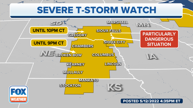
Particularly dangerous situation in Nebraska, South Dakota, Minn. and Iowa
Active Severe Thunderstorm Watch.
The Storm Prediction Center is calling Thursday's thunderstorm threat a particularly dangerous situation with possible widespread damaging winds up to 105 mph, large hail and tornadoes.
The Severe Thunderstorm Watch continues until 10 p.m. CDT for northwest Iowa, southwest Minnesota, northeast Nebraska and southeast South Dakota.
Emilee Speck
Threat of tornadoes returns to upper Midwest
The tornado threat for Thursday night.
Thursday's severe thunderstorms will bring the threat of possible EF-2 tornadoes.
The Storm Prediction Center has highlighted a "hatched area" in Central and Northeast South Dakota where there is a significant threat of tornadoes.
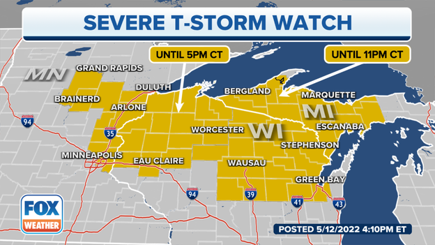
Severe Thunderstorm Watch underway for Minnesota, Wisconsin
Severe Thunderstorm Watches and Warnings for Thursday evening.
A Severe Thunderstorm Watch is underway for Central and eastern Minnesota and northwest Wisconsin until 5 p.m.
Severe Thunderstorm Watches were also issued for the rest of northern Wisconsin, the Upper Peninsula of Michigan, eastern Nebraska and northern Kansas until 9 p.m. Central.
Emilee Speck
You’ve reached the beginning of this live coverage.