What is a Rex block?
The Rex block is an atypical weather pattern that stubbornly blocks any incoming storms that usually travel on the westerly winds.
FOX Weather Explains: What is a Rex block?
A stubborn weather pattern, known as the Rex block, is anchoring hot and dry conditions over the Northwest and cool and stormy conditions over the Southwest.
October rain in Los Angeles and record heat in Seattle? It's an example of the upside-down weather that can occur with a "Rex block."
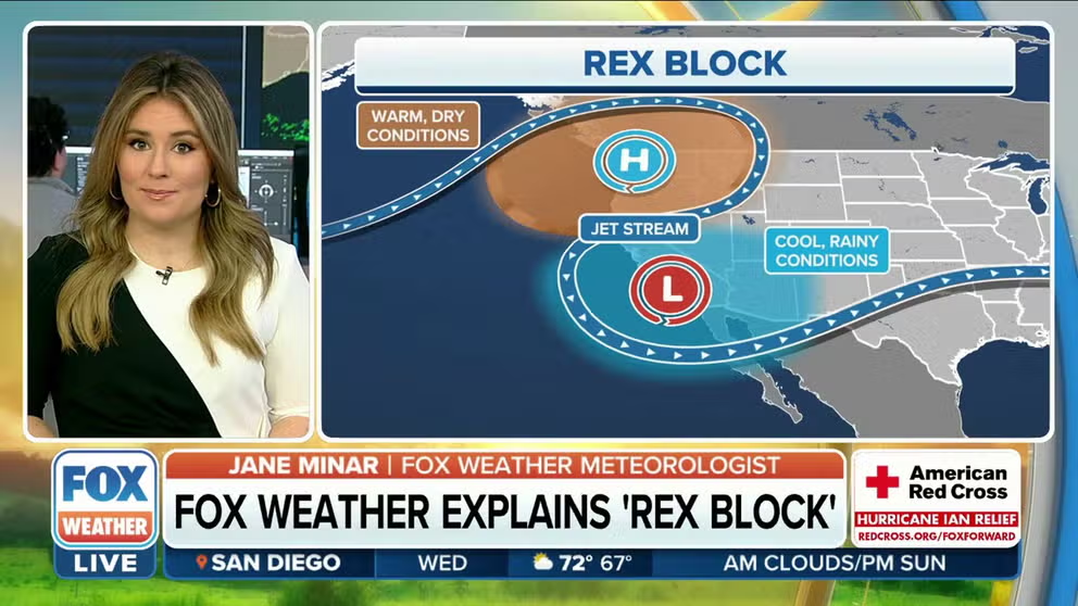
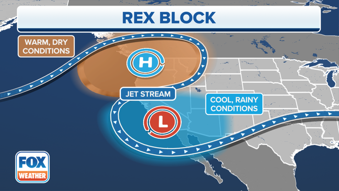
The Rex block is an atypical weather pattern that stubbornly blocks any incoming storms that usually travel on the westerly winds. It is a strong high-pressure system setting up north of an upper-level low-pressure system. This essentially cuts off the low-pressure system from the westerlies that would normally steer it.
"That's kind of a flip-flop for what we typically see," FOX Meteorologist Kendall Smith said during a Rex block pattern in October, 2022. "So, we're cool and kind of very wet in locations that are typically warm and sunny, and where the warm and sunny weather is, the Northwest, which historically speaking is one location where we're typically dry and chilly."
Blocking patterns like this one usually last 3 to 5 days and on rare occasions, for months, according to the University Corporation for Atmospheric Research.
WHY IS ATMOSPHERIC PRESSURE SO IMPORTANT TO THE FORECAST?
The block is named for meteorologist Daniel Rex who studied the pattern.
The graphic below depicts the blocking pattern, with this example showing high pressure with a clockwise flow of air over the Pacific Northwest and an upper-level low-pressure center with a counterclockwise flow of air over the Desert Southwest. The blue ribbon represents how the jet stream meanders between the two systems, instead of its normal west-to-east flow. When meteorologists see bulges and pockets like this, it spells unusual weather.
This pattern will stay in place until one of the systems changes intensity and throws the block out of balance, according to the National Weather Service.
HOW TO WATCH FOX WEATHER ON TV
(FOX Weather)
How a Rex block causes wacky weather
A high-pressure system forces air toward the surface of the Earth. That sinking motion quashes any chance of rain and heats up the air under it.
During the aforementioned October 2022 Rex block, record-high temperatures were common over Seattle and Portland.
Rex block anchoring hot dry conditions over Seattle
FOX 13 Seattle meteorologist Abby Acone explains how the Rex block and associated high pressure system impacts residents.
Seattle broke their record for the hottest first 10 days of October. The average of the daily highs hit 73.5 degrees, crushing the old record held since 1987. Portland’s 10-day average high was 80.1, breaking the city's 22-year-old record. Several other temperature and lack-of-rainfall records fell across several days in early October in the Northwest.
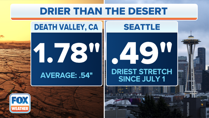
Death Valley has seen more rain than Seattle since summer began.
(FOX Weather)
Meanwhile, a low-pressure system does the opposite. It allows air to rise, which produces clouds. Those clouds can produce rain and thunderstorms, as well as keep temperatures on the lower side.
While the Northwest was baking in October, it was cool and showery in Southern California.